Trapper Peaks, Bitterroot Mountains
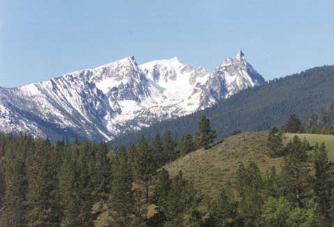
On 7 September 1805, the day after they left the Salish at Ross’s Hole, the Corps proceeded north down the Bitterroot River valley. “The foot of the Snow toped mountains approach near the river on the left,” wrote Clark. Among the more awe-inspiring features on the western skyline was the profile of the three rugged Trapper Peaks, the highest mountain in the entire Bitterroot Range. At 10,157 feet (3.1 kilometers), it’s not high in comparison with some of the pinnacles of the Colorado or Canadian Rockies, but nonetheless the Bitterroots presented the most challenging terrain the Corps encountered, and–fortunately for those who value wilderness for its own sake–it has changed but little since then.
The main Bitterroot Range, which bears 300 miles of the Montana-Idaho border on its ridges, from the Snake River Valley in Idaho to the Clark Fork River in Montana, can be crossed today in only three places. The expedition used two of them. The shortest, near the south end, is via U.S. Highway 93, over Lost Trail Pass, from North Fork, Idaho, to Conner, Montana. U.S. Highway 12 between Lolo, Montana, and Kooskia, Idaho, once known as the Lewis and Clark Highway, roughly parallels the Northern Nez Perce Trail that the expedition used from Travelers’ Rest on the east end to Canoe Camp on the west. The modern highway distance is only 110 miles; Lewis and Clark calculated the Northern Nez Perce Trail was 157 miles long.
The third option is the narrow, steep and rocky road (Forest Road 468) from Conner, Montana, to Elk City, Idaho. This route generally follows the ancient Southern Nez Perce Indian Trail, skirting Trapper Peak on the south (left in this photo). In 1854 Lieutenant John Mullan, of the Corps of Engineers, surveyed it as a possible route for an emigrant road, and ultimately a transcontinental railroad right-of-way, but considered “thoroughly and utterly impracticable for a railway.” The country was, he continued, “one immense bed of rugged, difficult, pine-clad mountains, that can never be converted to any purpose for the use of men.” Gruffly he punctuated his summary: “In all my explorations I have never seen a more uninviting bed of mountains.”
In the early 1860s, prospectors leaving Elk Citya, Idaho, for new gold strikes around Virginia City, Montana, considered it the most direct route. Soon the need for a wagon road from Lewiston, Idaho to Missoula, Montana became obvious. In 1866 Congress yielded to the pressure, funded the idea, and engaged two engineers, Wellington Bird and Major Sewell Truax, to build one along the general track of the Northern Nez Perce trail, K’useyneiskit. The southern road, passing through the so-called Magruder Corridor that marks part of the southern boundary of the Selway-Bitterroot Wilderness, is said to be the northwest’s longest unpaved road without services–113 miles.
Why didn’t the Lemhi Shoshone guide Lewis and Clark called Toby lead them over the Southern Nez Perce Trail? Since the option is not mentioned by any of the expedition’s journalists, we may assume it was never suggested to the captains. Perhaps Toby wasn’t familiar with it or, if he was, perhaps his people simply didn’t want strangers to know of it. But he might have known that the southern route was nearly 20 rugged, thirsty, hungry miles longer than the northern one, and the comparative ease of cruising down the broad level valley of the Bitterroot River would more than compensate for the additional miles the long northward detour involved. Moreover, the northern trail got Toby’s people to salmon beds and camas meadows that were higher up the streams than any other route. Maybe it was one of his favorite places, and maybe that’s why he ushered them down off of Lolo Pass into the headwaters of the Lochsa River, even though they had to make a strenuous climb to get back on the main road across the Bitterroots.[1]Reports of Explorations and Surveys, to ascertain the most practicable and economical route for a railroad from the Mississippi River to the Pacific Ocean, made under the direction of the Secretary … Continue reading
Notes
| ↑1 | Reports of Explorations and Surveys, to ascertain the most practicable and economical route for a railroad from the Mississippi River to the Pacific Ocean, made under the direction of the Secretary of War, in 1853-4 (Washington: Government Printing Office, 1855-61), Vol. 12, Part I, p. 248-49. |
|---|