Jefferson’s geographic directive to fix the trading route to the Pacific by observation meant that Lewis and Clark should mark territory—measure and map it by making marks on paper like a bear makes claw marks on trees
“Foot of the Mountains”
Detail from Clark’s Map
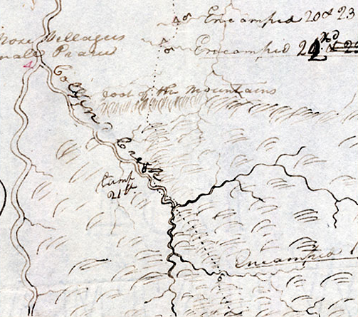
Beinecke Rare Book Library, Yale University
All organisms that must compete for resources—sunlight, air, water, food—are territorial. They have no choice but to stake their claim to a portion of the earth’s resource base and defend it. If they don’t, they don’t survive. The higher the order of an organism, the more territorial its behavior becomes until, with humans, just the threat of territorial competition is enough to cause conflict. Since we humans are the most territorial of organisms, we have the most well-developed abilities to recognize, organize and symbolize our territory with actual and mental maps. Because of our legal systems and institutions, we also have the greatest need to do so and that is what Thomas Jefferson was conveying in his instructions to Lewis. More than anything else, the objective of the Lewis and Clark Expedition was to lay claim to the new territory, and map it.
Jefferson’s Geographic Directive
In a letter to Meriwether Lewis dated 20 June 1803, President Thomas Jefferson provided these basic instructions:
Beginning at the mouth of the Missouri, you will take [careful] observations of latitude longitude, at all remarkeable points on the river, & especially at the mouths of rivers, at rapids, at islands, & other places & objects distinguished by such natural marks & characters of a durable kind, as that they may with certainty be recognised hereafter. The courses of the river between these points of observation may be supplied by the compass the log-line & by time, corrected by the observations themselves. The variations of the compass too, in different places, should be noted.
The interesting points of the portage between the heads of the Missouri, & of the water offering the best communication with the Pacific ocean, should also be fixed by observation, & the course of that water to the ocean, in the same manner as that of the Missouri.
Your observations are to be taken with great pains & accuracy, to lie entered distinctly & intelligibly for others as well as yourself to comprehend all the elements necessary, with the aid of the usual tables, to to fix the latitude and longitude of the places at which they were taken . . . .
Primary Objective
Mapping is the human equivalent of an animal marking its territory by leaving scent, spoor, or other traces. Jefferson’s instructions to fix the trading route to the Pacific by observation meant that Lewis and Clark should mark territory—measure and map it by making marks on paper like a bear makes claw marks on trees. These marks would allow those who followed Lewis to understand new American territory by using concepts they could readily comprehend, just like bears immediately know when they encroach on one another’s territory. For us to understand what the captains did in terms of mapping—recognizing, organizing, and symbolizing territory—and how they did it, it is necessary to go both backward and forward from the time of Lewis and Clark, and to establish some baselines and principal meridians of our own.
Experience the Lewis and Clark Trail
The Lewis and Clark Trail Experience—our sister site at lewisandclark.travel—connects the world to people and places on the Lewis and Clark Trail.
![]()
Discover More
- The Lewis and Clark Expedition: Day by Day by Gary E. Moulton (University of Nebraska Press, 2018). The story in prose, 14 May 1804–23 September 1806.
- The Lewis and Clark Journals: An American Epic of Discovery (abridged) by Gary E. Moulton (University of Nebraska Press, 2003). Selected journal excerpts, 14 May 1804–23 September 1806.
- The Lewis and Clark Journals. by Gary E. Moulton (University of Nebraska Press, 1983–2001). The complete story in 13 volumes.
This site is provided as a public service by the
![]()
Lewis and Clark Trail Alliance
with additional funding from the following:

