Thus have I walkt a wayless way, with uncouth pace, Which yet no Christian man did ever trace: But yet I know this not affects the minde, Which eares doth heare, as that which eyes doe finde.
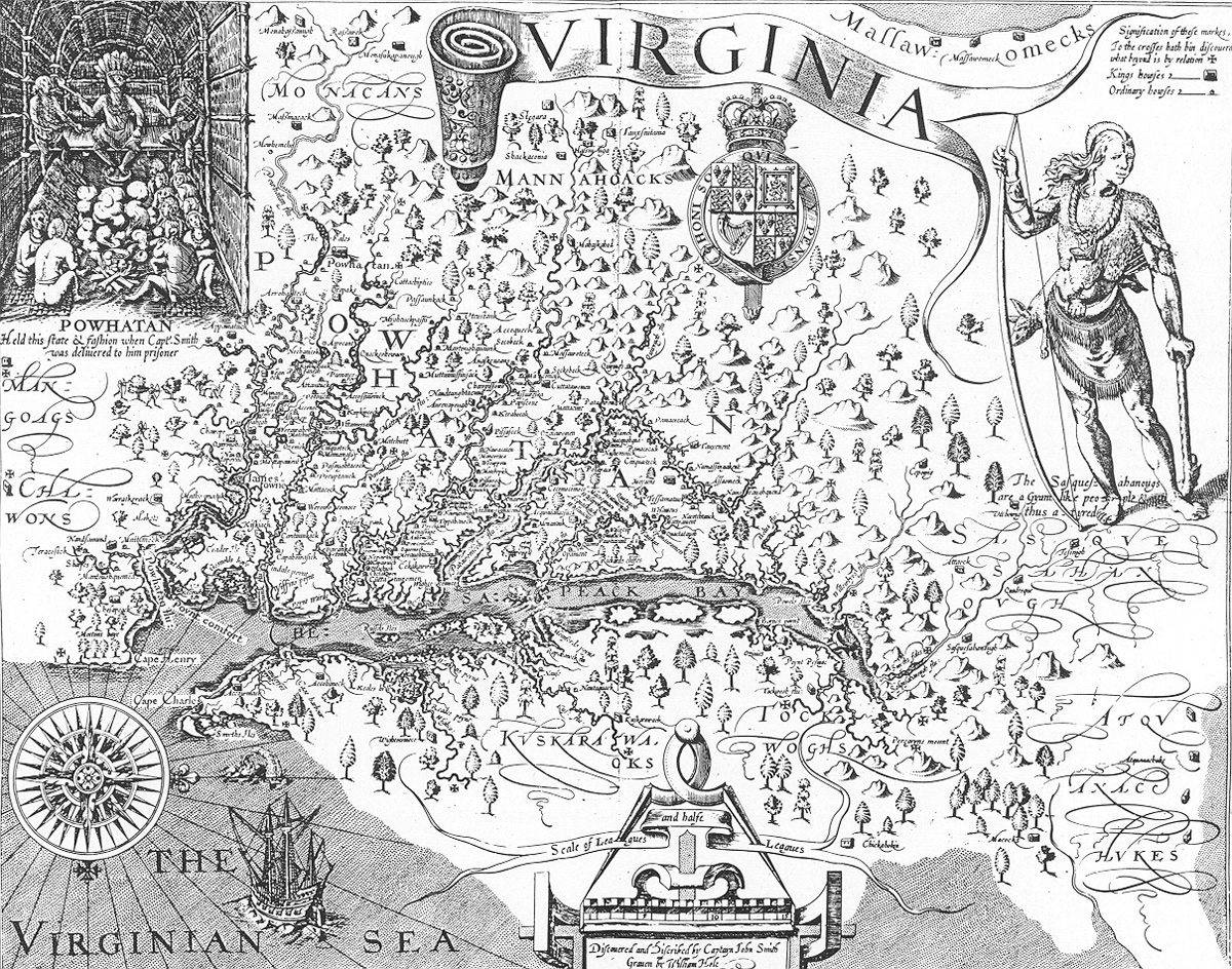
John Smith’s Map of Virginia, 1612
Human Mental Mapping
Captain John Smith was the first to draw a reasonably accurate map of Chesapeake Bay, with its many tributaries. He explored to the head of the Bay in 1607 and ascended many rivers into the interior in 1608. On the map, he noted his ascent with tiny crosses and located over 200 Indian villages, symbolized with tiny huts. The numerous trees and hills drawn on the map suggest a wooded, hilly terrain. Smith’s map is a classic example of a map that conveys accurate geographical information using pictures, rather than what we would today consider to be conventional cartographic symbols.
Clark constructed his mental maps before his actual maps. He fit everything into a grid system before ever putting it down on paper.
There are two basic human methods of mental mapping that we use every day to get around, to locate ourselves in reference to distance, direction, and time: one is by recognizing the real world with its landmarks, the other is by abstracting or imagining what the world looks like from high above the earth’s surface—in other words, looking at the world as if we were looking at a map. These two methods haven’t really varied all that much for thousands of years and have never relied on instruments other than the human senses.
Certainly, the needs of the Ice Age hunter in tracking, locating, and killing a wooly mammoth and then getting the spoils of the hunt back to the cave before they really became spoils were different from those of today’s shopper bound for the mall. But how people recognize, organize, and symbolize familiar territory is pretty much the same whether we’re dealing with Pleistocene hunters or modern shoppers, as long as we understand that there are these two fundamentally different ways of viewing the world, common to both the Pleistocene hunter and the modern shopper.
Horizontal Perspective
The view from the ground. Most people tend to imagine the world “horizontally,” visualizing distance and direction from a ground-level perspective and locating themselves in terms of personal space—left, right, front and back, up or down. These folks give and understand directions in terms of landmarks that can be seen from the traditional vantage point of having both feet in contact with terra firma: “See that hill? If you go to that hill and turn left through the woods and across the river, you’ll get to where the wooly mammoths live.” Or “Drive down this street until you come to the first Texaco station, turn left, go through two traffic lights, and the mall will be on your right.” Their maps and mapping techniques tend to be concrete rather than abstract: the river, the hill, the woods, the filling station, the traffic light are the features that dominate both their mental maps and their real maps or pictographic representations of the world they might make for others. When the person with a horizontal perspective wishes to map a forested area, he will most likely draw a bunch of tiny trees. In representing distance between the forest and the cave, or the filling station and the mall, he will use travel time as a surrogate. And in demonstrating the third dimension of terrain, he will draw hills and valleys as “flat” features in two dimensional form.
Vertical Perspective
Point, Line, and Area
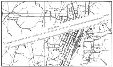
This map shows point, line, and area data presented as conventional cartographic symbols. A scale is superimposed on the map to indicate “proportionality” or the mathematical ratio between the real world and the map’s representation of it.
The view from above. Other people (a minority) tend to imagine the world “vertically.” They visualize distance and area in terms of the north-south (x) and east-west (y) coordinates of a two dimensional geographic grid system that they view from above. They give and understand directions in terms of the x-y reference points of the grid system. The world they carry around in their heads is the same world that they see on a conventional map: “Go two miles north, then 0.8 miles west, and the shopping mall will be on the north.” These people are able to interpret aerial photographs, satellite images, and conventional maps more easily than those who see horizontally. They readily convert direction concepts into latitude and longitude. They are better at abstract and symbolic mapping rather than pictographic mapping.
The mapmaker with the vertical perspective will show a forested area on a map by surrounding the area with a boundary and then filling it with a pattern or color that symbolizes “forest.” Distance may be indicated by specific linear numerical units like miles or kilometers and the map will be drawn at a defined scale in which distance is expressed in these linear units rather than time. And in showing the third dimension or coordinate of elevation (z), the mapper with the vertical perspective will use symbols like hachures, contour lines, or color tints to indicate relief features.
It is important to know here that the vertical perspective can be learned. Many extremely competent explorers, navigators, and others for whom an accurate sense of location-distance-direction is crucial, begin as people dependent upon visual landmarks but learn how to use both instruments and their own senses to locate themselves and other places within the framework of the three-dimensional coordinate system of latitude and longitude and elevation. William Clark, who almost always knew where he was and was a superb maker of maps, was probably one of those people for whom the vertical view of the world came naturally. For him, the use of astronomical instruments to identify precisely his geographic location (latitude and longitude) was verifying what he intuitively knew.
Mapping Terrae Incognitae
Elevation
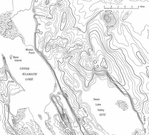
This map uses conventional contour line symbols to indicate elevation above sea level (note the numbers on some of the lines). A contour line is an “isoline,” connecting points of equal value. Elevations are also given as fixed points: the elevation of Swan Lake Valley is 4270 feet above sea level.
In traveling across the landscape of the real world between the Mississippi and the Pacific, Clark constructed his mental maps before his actual maps. He looked both forward and backward, recognizing the west side of landmarks as well as the east side, and fitting everything into an imaginary grid system before ever putting it down on paper. Meriwether Lewis, no less intelligent and every bit as competent in the field, was just as probably among those people who see the world horizontally. He had to learn to convert his habitual perspective into a vertical one for purposes of navigation and mapmaking. For him, establishing position by instrument was revealing the natural world through scientific measurement.
In the general workaday world of either the ancient hunter or today’s shopper, both the horizontal and vertical forms of spatial understanding suffice. Where problems arise with either type of spatial perspective, they come from attempts to recognize, organize, and symbolize territory that is unknown—terrae incognitae. The person who tries to connect his known world with an unknown world has a great deal of difficulty in doing so because his traditional methodology for getting around just doesn’t work very well where landmarks aren’t known and can’t be seen or where there are no primary reference points to obtain estimates of the dimensions of a geographic grid.
There are enormous differences between people in terms of both experience and technology. Consequently, how they go about filling these blank spaces—and telling others about them—is also vastly different. Experience and technology, leavened with imagination, are everything when people try to map world other than their own. Think of the difficulties in exchanging spatial information between peoples whose environments and technologies were as different as those of Lewis and Clark and the native peoples whose environments they were trying to navigate.
Mental Maps and the Modern Microcosm
Navigating in Space
Imagine the difficulty for a person with either the horizontal or vertical perspective in getting around in “outer” space rather than “earth” space. In traveling from the earth to the moon, for example, four dimensions are necessary: the traditional north-south-east-west horizontal coordinates, the vertical coordinates of up, down, and the fourth dimension of time.
Hitting the moon from the earth is shooting at a moving target from a moving platform and this requires elaborate calculations done (for reasons of speed and accuracy) by supercomputer instead of simple navigational instruments like those used by Lewis and Clark.
On the other hand, hitting the moon from the earth is not all that different from the hunter’s instinctive process, perhaps from the back of a moving horse, of making a snap estimate of how far away an animal is, how fast it is running, what the wind speed and direction is, and how to hold a rifle on a point so that after the trigger is pulled and the firearm discharges, a certain part of the animal’s anatomy and the slug from the rifle are going to arrive at the same point in space at the same time.
Lewis and Clark readily shot at moving targets—deer or elk or buffalo. How well do you think they would have done in making the elaborate calculations necessary to navigate from the earth to the moon?
Lewis and Clark measured the land they passed across, pace by pace, landmark by landmark, mile by mile. They estimated, calculated, compared, recalculated, and proceeded on, assembling their mental maps. Imagine all the ways in which their basic perceptions of time and distance and direction differed from those we might experience while traveling: how the captains’ sense of time and distance must have gotten all out of whack every now and then, just like ours does if we travel between familiar points but at speeds different from those we’re accustomed to.
How different must be the perceptions of time and distance of an astronaut orbiting the earth several times, or the modern air traveler flying from New York to Australia in about the same time required for those several earth orbits, from those of Lewis and Clark struggling a few dozen miles up the Missouri River during the period required for several shuttle orbits or a jet flight halfway around the world.
Imagine the difference in ease of the calculations we obtain instantaneously from a handheld GPS device, those that an astronaut obtains after a supercomputer processes billions of pieces of information, and those that Lewis and Clark made in bad weather, at night, by firelight, with a crow quill pen in an elkskin-bound book. Think what a feat it was for Lewis and Clark just to keep track of the right day of the week (don’t you ever lose track while you’re on vacation?).
The mental maps the captains acquired so laboriously quickly became real ones, penned on paper and then engraved on copper plate. How close their mental maps and their actual maps must have been! Although the real maps available to us are supremely accurate, our mental maps are not. We cross landscapes not by the windings of rivers but by the straight lines of interstate highways. We follow not the local curvature of the terrain but the global curvature of the earth, again in apparent straight lines that mark the great circle airline routes between the country’s and the world’s airline hubs.
The sense of place and space with which we come away from our travels is quite different from that of Lewis and Clark: the smell of gasoline and diesel fumes rather than that of wood smoke; the haze of city and suburban pollution rather than the clarity of the High Plains at sunrise; the accumulation of airport destinations as experiences rather than the numerous nightly camps along the great Missouri; a fast-food “happy meal” instead of buffalo hump rib.
Even along the Lewis and Clark Trail, the modern traveler’s experience cannot be like that of the Corps of Discovery: a few days in canoes through the Missouri’s White Cliffs country or a few days on horseback in the Bitterroot Mountains cannot add up to the incremental experiences and mental maps of 28 months from St. Louis to the Pacific and back again.