Some Indian maps are really pictures of an area, drawn by folks with a horizontal perspective, while others show evidence of having been drawn by mapmakers with a vertical perspective.
The Missouri River and Mandan Villages
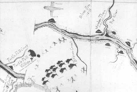
This map was drawn in 1906 or 1907 by Sitting Rabbit, a Mandan, and is judged by authorities on traditional American mapping to be one of the finest examples of pictographic mapping. Although the map is a correct representation of the course of the Missouri and several tributaries near the Mandan villages, it is also a picture, using images to portray location and meaning: the earthen lodges of the Mandans, a herd of buffalo, a horse corral. Totemic symbols are used to identify villages. Example: the device in the upper center that looks like an airplane is actually a pair of crossed snowshoes.
The centuries-long encounter between the natives of North America and Europeans or Americans tells us that indigenous peoples were no different than people anywhere else in falling naturally into the two groups of horizontal and vertical viewers. Despite sharing the horizontal-vertical perspective dichotomy with Europeans and Americans, Indians differed greatly from non-Indians in their manner of linking space and time, distance and direction. Certainly, this was true of the native peoples encountered by Lewis and Clark. The reasons for these differences were primarily the result of the contrasting needs of the hunter-gatherer and subsistence farmer versus those of the commercial farmer, townsman, or tradesman with respect to time, distance, and direction. They were also the consequence of considerably different technology.
Indian Time
Indians had little use for small elements of time. The cyclical passage of the seasons, marked by the “moons” of the lunar calendar that seems to have been a known feature of people for 35,000 years; the years, marked by the passage of “winters”; the division of days and nights into “sleeps”: these were sufficient for people who did not have to punch a time clock, “get to work on time,” or meet a train-bus-airplane schedule, and for whom, therefore, seconds and minutes and hours were generally useless.
Some native peoples in North America used a measure of time they called “a hand,” meaning the amount of time it would take the sun to pass from one side to the other of a hand extended at arm’s length toward the solar disk. But this measure was highly variable in a seasonal sense (it also would have varied depending on the size of the hand!) and probably was not widely adopted. Because the time-sense of native peoples was so vastly different from that of people who carried timepieces that marked seconds and minutes and hours, European and American explorers had difficulty translating native descriptions of time.
Indian Distance
The Upper Missouri Drainage
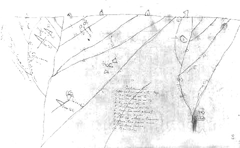
This map was drawn around 1802 by Old Swan, a Blackfeet Indian. It shows the drainage of the upper portions of the Missouri River from the Continental Divide (shown by the straight line at the top of the map). While some pictographs appear on the map, the general mapping pattern is more abstract, with line symbols to represent rivers.
Since the smallest unit of time with which Indians were normally comfortable was the solar day (sunup-to-sunup), and since they possessed no long-range distance concepts other than time, when asked for the distances between places they usually answered in terms of travel time, expressed as days or “sleeps.” And generally, when Indians provided explorers like Lewis and Clark with time-distance-direction information, that information was shaped by the Indians’ own experience.
How long it took to get from one known point (the Mandan villages) to another (the Great Falls of the Missouri) depended on how the Indians made the trip. If they normally made the trip between the Mandan villages and the Great Falls as an all-male raiding party heading for the Rockies to steal horses from the Shoshones, the distance between the two known points could have been “6 days.” On the other hand, if they traveled from the Mandan villages to the Great Falls as part of a seasonal migration pattern, moving with entire villages—men, women, children, dogs, etc.—then the distance might have been “20 days” or more. Lewis and Clark translated the Indians’ “days’ travel” into “25 miles”. Sometimes this worked. More often it did not and some wildly inaccurate distance estimates based on Indian information resulted.
Indian Direction
Sunset from Fort Mandan
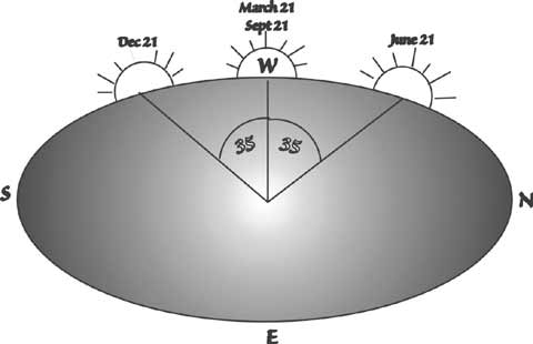
This image illustrates the location of sunset at equinox (21 March and 21 September ) and solstice (21 June and 21 December). During the time intervals between these dates, sunset falls between the marked positions on the western horizon. An angular error of 35 degrees will produce a direction error of 7 miles north or south of true west for every 10 miles traveled in a westerly direction.
Indians normally expressed direction with reference to sunrise or sunset, again as modified by experience. When Indians told explorers that a path between two known points lay “to the left of the setting sun” this did not necessarily mean that the path ran northeast-to-southwest. Native movements in space—especially long-distance movements—were undertaken at certain times of the year. Therefore, when they gave directions with reference to sunset or sunrise, they understood those directions in terms of the sun’s path in the sky at the times of the year when they took their journeys.
Lewis and Clark accepted Indian directional information as literal. “In the direction of the rising sun” meant “east.” “To the right of the setting sun” meant “northwest.” But for the Indian who lived near the mouth of the Knife River, north of today’s Bismarck, North Dakota, on the 47th parallel, the location of sunrise or sunset varied throughout a 70-degree arc of latitude over the course of a year and, therefore, their “West” or “East” could be as much as 35 degrees north or south from the cardinal compass directions. These direction variations allowed significant errors to creep into the coordinate systems of explorers’ maps and, because of the connection between directional error and distance, crucial distance errors appeared as well, making it understandable how William Clark, using what was probably quite accurate geographical information provided by the Hidatsas at Fort Mandan, could have mis-located the Three Forks of the Missouri by about 300 miles on a map of the West that he drew following the winter at Fort Mandan.
A Just So Story
Taffy’s Map from “How the First Letter was Written”
by Rudyard Kipling
Tne of the best descriptions of native peoples’ views of the world formed the basis for the tale of “How the First Letter Was Written,” one of Rudyard Kipling’s Just So Stories.
The speaker is a young prehistoric North American describing (in Edwardian English!) a combination map-and-letter made on birchbark to guide a visitor (“Strangerman”) to the cave where the speaker’s mother lives. The speaker is named “Taffy”—an appropriate name for an English girl of the late 19th century; but probably not just so for a Neolithic Indian:
“You go along till you come to two trees (those are trees), and then you go over a hill (that’s a hill), and then you come into a beaver-swamp full of beavers. I haven’t put in all the beavers, because I can’t draw beavers, but I’ve drawn their heads, and that’s all you’ll see of them when you cross the swamp. Mind you don’t fall in! Then our Cave is just beyond the beaver-swamp. It isn’t as high as the hills really, but I can’t draw things very small. That’s my Mummy outside. She is beautiful.”
Taffy is clearly using map symbols, pictures and words together to describe distance and location. She is also conveying a safety warning and a personal touch.
Experience the Lewis and Clark Trail
The Lewis and Clark Trail Experience—our sister site at lewisandclark.travel—connects the world to people and places on the Lewis and Clark Trail.
![]()
Discover More
- The Lewis and Clark Expedition: Day by Day by Gary E. Moulton (University of Nebraska Press, 2018). The story in prose, 14 May 1804–23 September 1806.
- The Lewis and Clark Journals: An American Epic of Discovery (abridged) by Gary E. Moulton (University of Nebraska Press, 2003). Selected journal excerpts, 14 May 1804–23 September 1806.
- The Lewis and Clark Journals. by Gary E. Moulton (University of Nebraska Press, 1983–2001). The complete story in 13 volumes.
This site is provided as a public service by the
![]()
Lewis and Clark Trail Alliance
with additional funding from the following:

