The Tools
Surveyor Compass
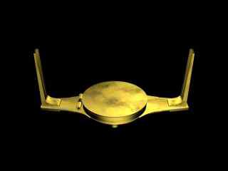
This instrument was normally mounted on the end of a staff that could be rested on the ground. The compass housing and the cross piece with the vertical metal “sights” on either end rotate. To take a bearing, Lewis or Clark would rotate the cross piece and upright sights while looking through the holes for a fixed visible point. When that fixed point was found, the bearing or azimuth between it and the observer could be read from the compass dial.
Compass Bearing: Azimuth
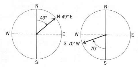
The word “azimuth” comes from an Arabic form of a Latin word meaning “way” or “path.” In the illustration, “N 49° E” is an azimuth indicating a compass bearing or direction of 49° east of north (or 41° north of east). “S 70° W” indicates a bearing or direction of 70° west of south (or 20° south of west). Lewis and Clark gave their compass bearings in terms of quadrants or quarters of the compass: 90° from north to east, 90° from east to south, 90° from south to west, and 90° from west back to north. Today, azimuths are often stated in terms of 360°, the full circle of the compass rather than quadrants. A modern statement of the azimuth of “S 70° W” would be 250°; degrees are always counted in a clockwise direction from compass north.
Much of what Lewis and Clark had to do in terms of their own mapmaking was to ascertain the accuracy of Indian information by doing what we call today “ground truthing”—checking Indian data against their own visual observations—and “celestial reckoning,” using the instruments they carried for the purpose of fulfilling Jefferson’s instructions to “take [careful] observations of latitude & longitude.” To fulfill these tasks they used instruments: spirit and telescopic levels, several compasses including a surveyor’s compass or circumferentor with extra needles and even a magnet to “polarize” them, a sextant, a “Hadley’s quadrant” or octant, rods and chains, telescopes, artificial horizons, drafting instruments, a very early version of a measuring tape, and a clock or chronometer. They also used books and tables giving the daily locations of sun, moon, and planets for use in computing geographical position after obtaining sightings of these “celestial objects.” The two most important groups of items of the Lewis and Clark Expedition, if cost is the measure, were mapping instruments and gifts for native peoples: these were the tools of empire, necessary in establishing a claim to place and space and defending that claim through trade.
Both Lewis and Clark were reasonably proficient in the use of these instruments and for 28 months, as long as the Expedition was on the move, a part of the daily routine was the measurement of latitude and longitude and the calculation of course, time, and distance of travel. Even during those times when Lewis and Clark were fixed in location for lengthy periods of time, such as at Fort Mandan and Fort Clatsop, the “mathematical instruments” saw almost daily use, weather permitting.
In this, the captains followed Jefferson’s geographic directives to the letter and throughout the Expedition made the two basic types of geographical observations their sponsor had requested: (1)daily measurements of local features, taken continually during a day’s travel; and (2)the more abstract measurements of latitude and longitudinal position, usually made by astronomical observation when and where atmospheric conditions allowed, but most commonly at camp during the night. Their guides were the moon and the stars.
By far the most common observations were the daily measurements that are found in the journals of Lewis and Clark as “Course . . . Time . . . Distance . . . Remaks. & refurncs.” These were intended to be used as the early 19th century equivalent of the guide book from AAA, that tells you how to get from place to place, what sights you’re going to see on the way, where to lay up at night, and where to get a good chicken-fried steak.
Compass
William Clark’s Compass
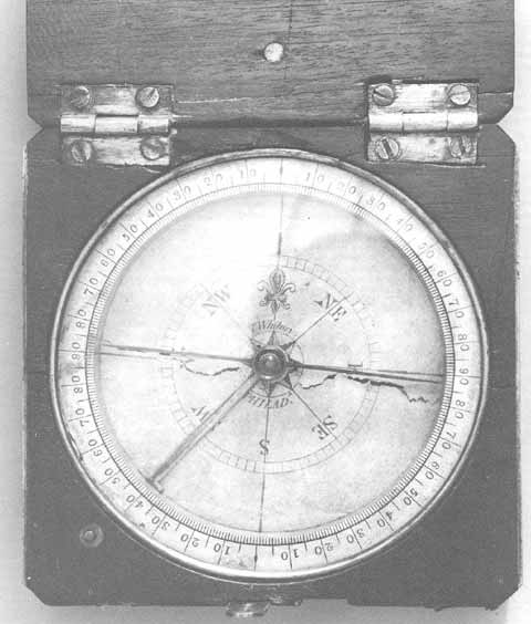
This is the actual compass, with a paper dial (note the tear across the dial), carried by William Clark on the Expedition. The compass is in a hinged box that can be closed to protect the compass face and is small enough to be carried in a large pocket. The compass ring showing degrees on the outside of the dial can be rotated to adjust the instrument for declination.
Course referred to the direction the expedition was traveling, stated as a compass bearing between two points. To obtain this bearing, or “azimuth,” the captains used one of the pocket compasses or else the larger surveyor’s compass (circumferentor) to get direction from one reference point to another—from the point of a bluff along the Missouri’s north side, for example, to the tip of a prominent sandbar on the south side of the river (reference points were always identified in the journals). Their compasses registered magnetic north rather than geographic north and their readings had to be adjusted for the difference or “declination.” They understood the errors that would creep in as they moved from east to west across the continent and continually adjusted the declination of their compasses to insure accuracy of readings.
The variations between magnetic north and “true” or geographic north have been understood for several hundred years. As early as 1585, a Portuguese map showed “isogonic lines” or lines indicating the declination or difference between north as it appeared on a compass and north as a direction of the geographic grid system.
The English scientist Edmund Halley (for whom the first comet to be recognized as such was named), drew a map of the world in 1702, showing isogonic lines for the entire planet and enabling explorers everywhere to correct their compasses for the difference between magnetic and true north.
The great English explorer, Captain James Cook, was the first to use compass declination widely in his mapping of the islands and coasts of the Pacific Ocean. Magnetic poles shift over time, and magnetic north in 1804-1806 was different from today.
Chronometer
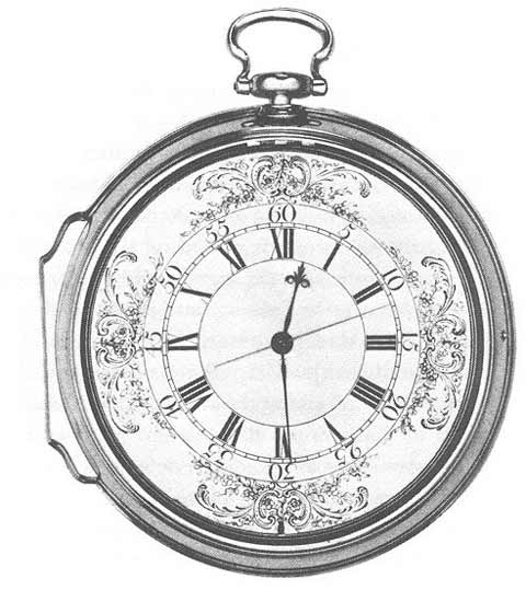
Chronometer
Time, stated in hours and minutes, was the time required to get from the reference point used to establish the beginning of a course azimuth to the reference point marking the end of that particular compass bearing. Time was established precisely by chronometer—as long as the captains remembered to keep it wound. Because they did forget to wind it regularly there were frequent occasions when travel time was an estimate. But living as close as they did to the natural world, while still having a temporal frame of reference that included hours and minutes and seconds, reasonably accurate time estimates would have been less of a problem for them than for the native peoples who possessed few or no short-term time concepts, or for us latter-day folks who are not only more divorced from nature but have relied for so long on the watches strapped to our wrists that we find it difficult to evaluate time any other way. Still, most of the temporal observations of Lewis and Clark were obtained by timepiece—the chronometer that cost more than all the rest of their “mathematical instruments” combined.
From the standpoint of navigation, the chronometer was one of the most important inventions of the 18th century. While this instrument looks a little elaborate for rough fieldwork, it performed well as long as it was kept wound. Note that the dial is calibrated in 12-hour increments rather than the 24-hour Greenwich Mean Time system used today for locational calculations. Much of modern naval terminology stems from the earliest nautical uses of the chronometer. The ship’s bell, by which time was noted, was struck at specific intervals (“eight bells” denoted the passage of four hours), a level of accuracy not possible prior to the chronometer. And “watches,” or the positions of responsibility for maintaining the ship’s course during four-hour intervals, were also regulated bv the new device.
Distance
Distance was expressed between the same two points used to derive course and time. This was normally given in miles but occasionally in yards or rods. These measurements were obtained either by pacing a course between two points or by estimating distances. Estimations are relatively easy for people having long familiarity with their environment, their own travel paces and their mode of transport. They walked about as often as they rode and this allowed them to judge both time and distances much more accurately than we can while driving a car at speeds that may vary widely (from 15 miles per hour in a school zone to 75 mph on an interstate highway).
Their sense of time and distance was more precise than ours because their survival so often depended on it and because they moved across the landscape in very different ways than we do. Throughout the expedition, the captains were reasonably accurate in their measurement of distance. They accomplished this with good guesswork, enlisted men to do the grunt work of pacing out courses, fairly sophisticated instruments and mathematical calculations, and careful attention to detail.
Remarks
Remarks, or reference observations, were comments on the widths of the Missouri and the creeks and smaller rivers that entered it, the heights of bluffs or hills along the river, and–most common and most important–the identification of the reference points upon which the compass bearing/distance/direction information was based. Jefferson’s directive to Lewis had included the order to note “all remarkeable points on the river, & especially at the mouths of rivers, at rapids, at islands, & other places & objects distinguished by such natural marks & characters of a durable kind, as that they may with certainty be recognised hereafter” and the captains were faithful to these instructions.
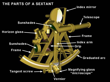
Sextant and Octant
Sextant
Octant

On 22 July 1804, while at White Catfish Camp on the Missouri River, ten miles above the mouth of the Platte, Lewis took time to enter into his journal brief descriptions of the instruments he and Clark used in making celestial observations:
1st— a brass Sextant of 10 Inches radius, graduated to 15′ which by the assistance of the nonius was devisible to 15″; and half of this sum by means of the micrometer could readily be distinguished, therefore—7.5″ of an angle was perceptible with this instrument; she was also furnished with three eye-pieces, consisting of a hollow tube and two telescopes one of which last reversed the images of observ ed objects. finding on experiment that the reversing telescope when employed as the eye-piece gave me a more full and perfect image than either of the others, I have most generally imployed it in all the observations made with this instrument; when thus prepared I found from a series of observations that the quantity of her index error was 8′ 45″—; this sum is therefore considered as the standing error of the instrument unless otherwise expressly mentioned. the altitudes of all objects, observed as well with this instrument as with the Octant were by mens of a reflecting surface; and those stated to have been taken with the sextant are the degrees, minutes, &c shewn by the graduated limb of the instrument at the time of observation and are of course the double altitudes of the objects observed.
A common Octant of 14 Inches radius, graduated to 20′, which by means of the nonius was devisible to 1′, half of this sum, or 30″ was perceptible by means of a micrometer. this instrument was prepared for both the fore and back observation; her error in the fore observation is 2°+, & in the back observation 2° 11′ 40.3″+ at the time of our departure from the River Dubois untill the present moment, the sun’s altitude at noon has been too great to be reached with my sextant, for this purpose I have therefore employed the Octant by the back observation. the degrees ‘ & ” [minutes and seconds], recorded for the sun’s altitude by the back observation express only the angle given by the graduated limb of the instrument at the time of observation, and are the complyment of the double Altitude of the sun’s observed limb; if therefore the angle recorded be taken from 180° the remainder will be the double altitude of the observed object, or that which would be given by the fore observation with a reflecting surface.
Estimating Distances
If the distance between reference points A (for example, the upstream tip of a prominent sand bar) and B (the top of a river bluff) is known, and the angles x and y can be read from compass bearings between B and C (a tall tree on the opposite side of the river) and A and C, then lines can be drawn from A to C and B to C completing a triangle with one known leg (AB) and two legs (BC and AC) that can be estimated with a high degree of accuracy.
This estimation can be done by “scaling.” If line AB is 1 mile long in the real world and 10 inches long on the diagram, then the map scale is 0.1 inches to 1 mile; the distance from B to C can be determined by measuring the distance on the diagram and multiplying by the scale (if the diagram distance BC is 6 inches, then real world distance is 6 miles). There are also mechanical ways that the distance estimates could be arrived at, using draftsman’s dividers or a similar instrument. The points of the divider could be set 1/10 of an inch apart to represent the diagram scale and the dividers could then be “walked” along line BC to determine its length.
Starboard? Larboard?
The reference points that made up the bulk of the notations in the Journals were often given as follows: ” . . . a pt. on L.S. high Land psd. the head of an Isd. above is a large Sand bar on L.S.”. This identifies a high point of land on the larboard side of the boat (“L.S.”), just beyond (“psd.” = “passed”) the upper portion or “head” of an island (“Isd.”) on the left. Normally, the captains used “larboard” and “starboard” to mean the left and right side of the boat.
Occasionally, they referred to the left or right banks of the river but this did not necessarily mean the bank on the left or right side of the boat. For river travelers in the early nineteenth century, the convention was to name the banks of a stream based on the direction in which the stream was flowing. For a stream flowing from the north, then, the right bank was the west bank, on the right hand side of someone traveling south down the river.
For Lewis and Clark, on their upstream journey, the left and right banks of the Missouri were to the right and the left respectively of the boat. In other words, the right bank of the Missouri (to Lewis and Clark) was the bank on their left as they proceeded upstream, on their right as they proceeded downstream. Those who followed immediately after Lewis and Clark were much less confused than we are about this system and the “references” material was among the most useful parts of the written record of the Expedition
Global Positioning System
Lewis and Clark tested Indian data by astronomical and other readings obtained under conditions that would defeat most of us today: heat, cold, wet, dry, darkness, hunger. It often took three or four men to complete the necessary mechanical operations necessary to get even a moderately accurate figure for the elevation of the sun or moon above the horizon and the end results of their calculations were, by modern standards, not very good.
Today, someone with but a few minutes of training can use a hand-held GPS (Global Positioning System) device to download latitude and longitude information from an orbiting satellite, link that information to a portable computer that will show a map locating the coordinate position of the observer, accurate to within a few meters. And the cost of the modern equipment (including the computer), in 1804 dollars, is only a small fraction of the money spent by Lewis on his “mathematical instruments.”
Since we already have reliable maps, identifying a location precisely on the landscape for us is merely a convenience that helps us find our way to a new and unfamiliar place. The handheld GPS device is to us, quite simply, a toy. For Lewis and Clark, who paid an enormous sum for a somewhat reliable watch, such a device would have been priceless.
Experience the Lewis and Clark Trail
The Lewis and Clark Trail Experience—our sister site at lewisandclark.travel—connects the world to people and places on the Lewis and Clark Trail.
![]()
This page was funded in part by a grant from the National Park Service's Challenge Cost Share Program.
Discover More
- The Lewis and Clark Expedition: Day by Day by Gary E. Moulton (University of Nebraska Press, 2018). The story in prose, 14 May 1804–23 September 1806.
- The Lewis and Clark Journals: An American Epic of Discovery (abridged) by Gary E. Moulton (University of Nebraska Press, 2003). Selected journal excerpts, 14 May 1804–23 September 1806.
- The Lewis and Clark Journals. by Gary E. Moulton (University of Nebraska Press, 1983–2001). The complete story in 13 volumes.
This site is provided as a public service by the
![]()
Lewis and Clark Trail Alliance
with additional funding from the following:

