Snowbank Camp
Lolo Trail near Snowbank Camp
View, west
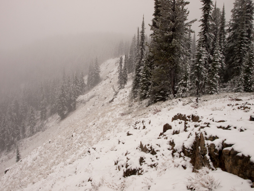
© 24 October 2010 by Kristopher K. Townsend. Permission to use granted under the Creative Commons Attribution-Share Alike 4.0 International license.
Clark undoubtedly noticed the main trail continuing in both directions when he intersected it on the main ridge at the summit of the nameless mountain, and sketched a bit of it as a reminder for the return trip. He may, in fact, have been recording his short side trip to the top of the mountain an eighth of a mile east and 250 feet above the shallow saddle where they had reached the top of Wendover Ridge. “From this point,” he wrote, “I observed a range of high mountains Covered with Snow from S E. to S W with Their top bald or void of timber.” Presently the party dropped down into a shallow saddle at the 6,400-foot elevation and pitched camp “near a Bank of old Snow about 3 feet deep.” It had been a long, thirsty climb since leaving the spring where Clark waited for the rest of the party to catch up, and now a hard-packed snowbank was their only source of water to wash down the remains of the horse meat they had carried all the way from Colt Killed Camp. As any wintertime camper can imagine, melting enough snow to satisfy man and beast for a supper and a breakfast can consume a lot of time, fuel, and patience. Although none of the journalists mentioned it, the very presence of last winter’s snow on those mountains in late September must have aroused the feeling that crossing the Rockies was going to be even tougher than they had figured.
Spring Mountain
A Stormy Fall Day on Spring Mountain
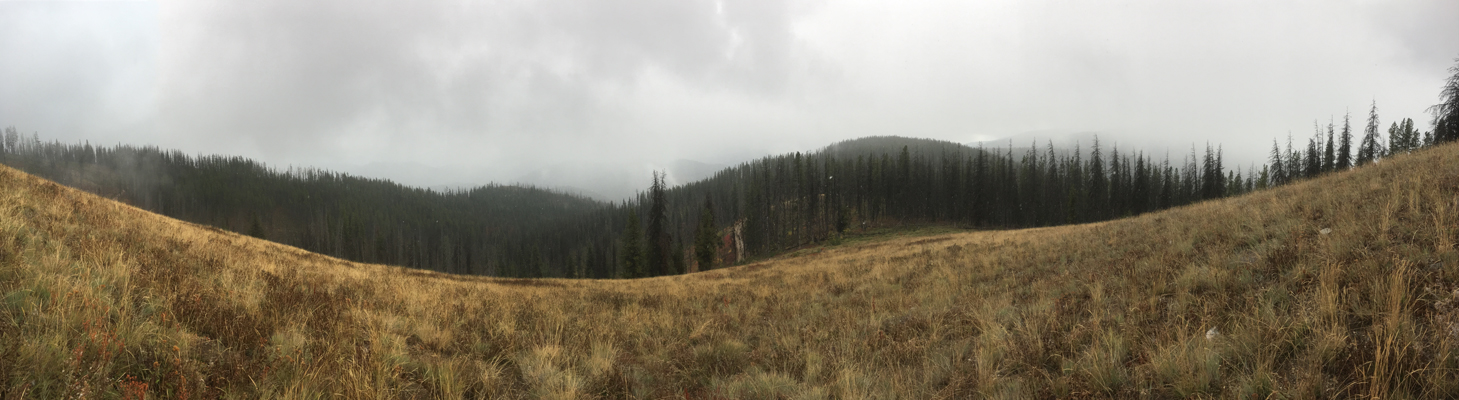
© 4 October 2016 by Kristopher K. Townsend. Permission to use granted under the Creative Commons Attribution-Share Alike 4.0 International license.
While shooting this photo, the snow was melting as fast as it fell. A flew flakes can be made out in front of the trees. On the same day at Snowbank Camp, there was over an inch of snow on the ground.
Winter seemed well under way by the sixteenth of September, when the expedition made a noontime stop on Spring Mountain to let their horses rest and graze on the last grass of the summer under the new-fallen snow. It was a welcome respite for all. In the surrounding forest the tree branches were bent low with snow that the horses and riders dislodged as they passed, and thoroughly drenched them by the end of the day. “I have been wet and as cold in every part as I ever was in my life,” Clark complained. “Indeed I was at one time fearfull my feet would freeze in the thin mockersons which I wore.” (The conditions may have reminded him of the hunger and cold he had experienced on the trip he commanded on the Wabash River in midwinter, 1793-94, carrying clothing to troops at Fort Vincennes.)[1]Landon Y. Jones, William Clark and the Shaping of the West (New York: Hill and Wang, 2004), 73-74. After lunch—called “dinner” in those days—Clark pushed on ahead for six miles to “a Small branch passing to the right,” possibly Horseshoe Creek. There, at the place Whitehouse described as “a lonesome looking cove,” he and the man accompanying him built fires to cheer and warm Lewis and the rest of the wet, weary, and undoubtedly hypothermic company.
However, the captains were not so distracted by the weather that they neglected their duties as explorers. They took time to observe the differences among the eight evergreen conifers they encountered along their way, although they didn’t list any details.[2]Lodgepole pine, Douglas fir, subalpine fir, Englemann spruce, whitebark pine, grand fir, and mountain hemlock Those would come in due time.
Indian Post Office
A Snowy Day at Indian Post Office
360° panoramic photo
© 4 October 2016 by Kristopher K. Townsend. Permission to use granted under the Creative Commons Attribution-Share Alike 4.0 International license.
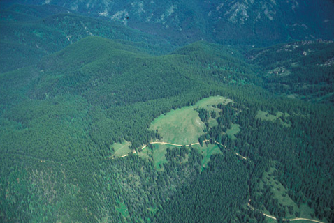
Indian Post Office by Air
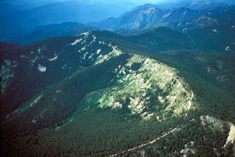
© 2001 Airphoto, Jim Wark. Permission to use granted under the Creative Commons Attribution-Share Alike 4.0 International license.
Etching its way along the ridge down there is the Lolo Motorway, the rough single lane motorway that was completed in 1934 by the Civilian Conservation Corps, an agency established during President Franklin Delano Roosevelt’s administration to provide jobs and carry out projects to restore and preserve the country’s natural resources, especially in the West.
Sometime on 16 September 1805, the Corps of Discovery passed along the brink of this basin, possibly where the Lolo Motorway is now. They were too cold, hungry, and generally miserable to admire the scenery. They couldn’t have seen much of it anyway. Snow fell throughout the day, adding a total of 6 to 8 wet, slippery inches on top of what remained of the previous winter’s hardened snowpack. “Indeed,” fretted Clark, “I was at one time fearfull my feet would freeze in the thin mockersons which I wore.”
If there was a rock cairn on the ridge between Post Office Creek and Howard Creek when the Corps of Discovery passed by, none of the journalists mentioned it, and none ever used the expression Indian Post Office,” which some unknown “authority” since then has hinted was a secret means that Indians once used to communicate with other travelers along K’useyneiskit. That theory is apocryphal, although actually it would have been the logical place for some sort of a marker, for in order to get around Indian Peak, from which there was no way to proceed westward, the Indian road took a sharp turn to the north, dove down into the valley, crossed Howard Creek to Moon Creek, then regained the ridge at Moon Saddle.
Lonesome Cove Camp
Lonesome Cove
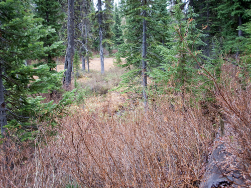
© 23 October 2010 by Kristopher K. Townsend. Permission to use granted under the Creative Commons Attribution-Share Alike 4.0 International license.
This meadow is part of a series of small openings below Indian Post Office as located by trail researcher Gene Eastman.
In his map, Clark seems to indicate that the Indian road followed a more or less distinct ridgeline (see Mapping the Lolo Trail). One authority, however, maintains that from Spring Mountain the road–or at least one of its principal tracings–dropped down on the north side of the ridge some 1500 feet to Moon Creek, followed Howard Creek, crossed over into Gravy Creek, thence up Serpent Creek back to the ridge.That is the route as shown on the most recent USGS maps.[3]Ralph S. Space, The Lolo Trail: A History and a Guide to the Trail of Lewis and Clark (2nd ed., Missoula, Montana: Historic Montana Publishing, 2001), 29. National Geographic Maps: Idaho, 2002. Another believes they descended into the Howard and Moon Creek drainages, and returned to the ridge at Moon Saddle.[4]James R. Fazio, Across the Snowy Ranges: The Lewis and Clark Expedition in Idaho and Western Montana (Moscow, Idaho: Woodland Press, 2001), 75-79. Clark shows the road descending into the Gravy Creek drainage, and places their camp of the sixteenth on a tributary that may be today’s Horseshoe Creek.
On the other hand, Private Joe Whitehouse’s journal for the sixteenth clearly indicates that Clark’s sketch is generally correct. They “kept on the ridge of the mountain,” he wrote. “Several high knobs to pass over but had more down hill than up.” Towards evening they “descended the mountain; down into a lonesome looking Cove on to a Creek, where we encamped in a thicket of spruce Pine timber.”
This was one of the most terrible days of the crossing. Some of the men (Whitehouse again) were “without Socks, and [were] forced to wrap Rags round their feet to keep out the cold.” That couldn’t have helped for long. They had wakened under two inches of new snow, and the storm continued until it was nearly six inches deep, some of it atop icy, compacted snowbanks left over from the previous winter. (Imagine hiking in wet rags through snow-covered ice!) They skipped breakfast simply for lack of anything to eat. At noon they melted snow and made some portable soup. Like bouillon before a five course dinner, it merely whetted their appetites without nourishing them sufficiently to cope with the cold and the work they faced. Captain Clark took seven shots at the only deer they saw that day, but the flint was loose in the lock and the gun didn’t fire.
They made the best of the worst, however. “Killed a Second Colt,” Clark explained, “which we all Suped hartily on and thought it fine meat.” That decision impeded their timely departure the next morning, but not on account of indigestion.
Spring Return
Spring Mountain
Early Summer, 2001 (view north)
© 2001 Airphoto, Jim Wark. All rights reserved.
En route to this open ridge on 27 June 1806, the captains looked down toward the north on two drainages that they recognized as tributaries of the North Fork—their “Chopunnish River”—that are now named Moon and Howard Creeks. On the morning after their supper of roots boiled in bears’ oil the men found that some of their gaunt horses had “straggled to a considersble distance” to feed on the new and still sparse grass. The sun on its daily progress northward from the equator had melted the snow from this generous opening, and brought forth a field of “the yellow lilly with reflected petals in blume”—The cheerful but modestly heads-down glacier lily, Erithroniium grandiflorum. By comparison, spring was arriving on today’s Spring Mountain a full seven weeks after it had shown its colors on the plateaus above the Clearwater River.
On the twenty-sixth of June the Corps reached the cache where they had left most of their baggage nine days before, loaded up their horses, then “cooked and made a haisty meal of boiled venison and mush of cows [cous].” (And the hastier the better, as far as cooking was concerned, because the fire was digging its own hole in the snow, the hotter the faster.) The whole party was standing on snow seven feet deep, so there was nothing for the horses to eat. No one mentioned what either men or horses had for supper that evening, and the fact is that their cupboard was nearly bare. The next day they marched 28 miles “without releiving the horses from their packs or their having any food,” and one imagines that hunger pangs made those animals restive and hard to handle. The party fared only a little better. “Our meat being exhausted,” wrote Clark, “we issued a pint of bears oil to a mess[5]Back at Camp Dubois on 1 April 1804, the captains had issued detachment orders dividing the company into three squads. Further, the orders read:The Camp Kittles, and other Public utensels for Cooking … Continue reading which with their boiled roots made an agreeable dish.” At least the people got a few calories and vitamins. Their bivouac that night was somewhere on Spring Mountain.
Twenty inches of the snowpack had melted while the Corps of Discovery was biding its time, but the going was still treacherous. Gass complained of “some of the steepest mountains I ever passed,” explaining that the snow was so deep “that we cannot wind along the sides of these steps [steeps?], but must slide straight down.” The horses’ hooves generally sank only a few inches into the hard-packed snow, but once in a while a horse would suffer a jolting plunge to its belly, presumably in places where the snow was undermined by water from the melt. Fortunately, the men had recalled their experience on the snowy road the previous September, and carefully saved their socks until now. Otherwise, the day was pleasant, although Gass felt that “it appeared to me somewhat extraordinary, to be travelling over snow six or eight feet deep in the latter end of June.”
Notes
| ↑1 | Landon Y. Jones, William Clark and the Shaping of the West (New York: Hill and Wang, 2004), 73-74. |
|---|---|
| ↑2 | Lodgepole pine, Douglas fir, subalpine fir, Englemann spruce, whitebark pine, grand fir, and mountain hemlock |
| ↑3 | Ralph S. Space, The Lolo Trail: A History and a Guide to the Trail of Lewis and Clark (2nd ed., Missoula, Montana: Historic Montana Publishing, 2001), 29. National Geographic Maps: Idaho, 2002. |
| ↑4 | James R. Fazio, Across the Snowy Ranges: The Lewis and Clark Expedition in Idaho and Western Montana (Moscow, Idaho: Woodland Press, 2001), 75-79. |
| ↑5 | Back at Camp Dubois on 1 April 1804, the captains had issued detachment orders dividing the company into three squads. Further, the orders read: The Camp Kittles, and other Public utensels for Cooking Shall be produced this evening after the parade is Dismissed; and an equal division shall take place of the Same, among the non commissioned officers Commanding the Squads. Those non-commissioned officers Shall make an equal Division of the proportion of those utensils between their own messes of their respective Squads,– each squad shall be devided into two messes, at the head of one of which the Commanding Serjeant Shall Preside. the Serjeants messes will Consist of four privates only to be admitted under his discrission, the ballance of each Squad Shall form the Second mess of each Squad. That organization facilitated cooking, as it would be faster for six cooks to work at small fires than to rustle food for 23 men at once over a large one. The two captains, York, Charbonneau, and Sacagawea together formed a seventh mess. |