“A pretty little plain”
Blossom Time in Packer Meadows
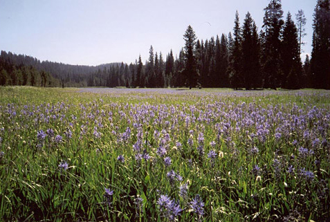
Looking eastward at the camas blooms in Packer Meadows while standing in the tread of the old Northern Nez Perce Trail.
—Steve Russell
At noon on 29 June 1806, the Corps arrived back at the familiar “quamas flatts,” on the ridge that divides the Clearwater River basin from that of the Clark Fork River. Lewis acknowledged it was “a pretty little plain of about 50 acres plentifully stocked with quawmash.” Furthermore, he saw ample evidence that this was “one of the principal stages or encampments of the indians who pass the mountains on this road.” That evening they camped at the hot springs, just seven miles north of the meadows.
Packer Meadows in Autumn
Packer Meadows in Autumn
Photography by Mike Dreesman.
In this movie, the helicopter is over the stream Lewis and Clark called Glade Creek (today, Pack Creek), looking upstream. At the outset, the aircraft has just passed above the site of the Corps’ camp of 13 September 1805, and is heading upstream toward the camas meadows. The party probably entered the meadows through the trees at left, about where the present forest access road becomes visible. As the scene concludes, Glade Creek enters the meadows from among the trees to the right of the road.
The road is on the Lochsa River side of the Bitterroot Mountains near the ridge dividing the Lochsa-Clearwater River drainage from the Lolo Creek-Bitterroot-Clark Fork drainage, both in the Columbia River basin.
Aerial View
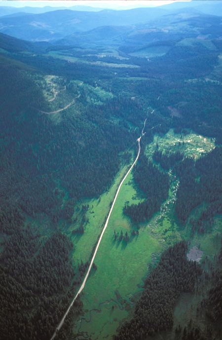
This photo, taken from about 1200 feet above the ground, includes the sources of Pack Creek—Lewis and Clark’s Glade Creek—among the trees at right of center, flowing northward toward the bottom of the photo.[1]The Lolo Creek of Montana (named “Travellers Rest” by Lewis and Clark), which empties into the Bitterroot (i.e., Clark’s) River, rises among the mountains to the left of this … Continue reading The main camas meadow, the “pretty little plain” Lewis admired, is at lower center on both sides of the road. The Corps of Discovery entered the meadow near the point where the road emerges from the trees at lower left. Their camp on the night of 13 September was below this photo and to the right.
Pack Creek is on the Idaho side of the divide between the Bitterroot-Clark Fork drainage and the Lochsa-Clearwater River drainage. The road, which was built in the early 1950s for access to the timber resource, begins on Lolo Pass (elevation 5160 feet) at U.S. Highway 12, one mile out of the photo at lower left. It winds generally eastward through the mountains among the forest clearcuts, and re-enters the Lolo Creek (Travelers’ Rest Creek) valley near the expedition’s campsite of 11 September 1805.
At the present time (November 2004) no logging has been carried on in this area for the past fifteen years. The major timber companies formerly active here have moved their operations to the Southeastern U.S., where merchantable trees grow faster.


Packer Meadow is a High Potential Historic Site along the Lewis and Clark National Historic Trail managed by the U.S. National Park Service. The Clearwater National Forest manages the site and the nearby Lolo Pass Visitor Center.—ed.
Notes
| ↑1 | The Lolo Creek of Montana (named “Travellers Rest” by Lewis and Clark), which empties into the Bitterroot (i.e., Clark’s) River, rises among the mountains to the left of this photograph. |
|---|