Lochsa River Headwaters
View Northwest
To see labels, point to the image.
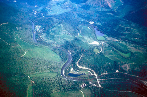
The treeless areas on the mountainsides (at left and top) have been clearcut–all or most of the trees have been removed for lumber. The clearcuts shown are verdant with a May-time ground cover of grasses, shrubs, and the many seedlings planted in order to re-establish the forest.
Crooked Fork Crossing
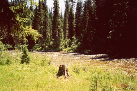
© 2001 Steve F. Russell.
Looking westward at the exact place where the Lolo Trail crossed Crooked Fork. There was another flat on the west side (now hidden by trees) that was also used for camping. This shallow rocky crossing is described by several travelers who used it after Lewis and Clark.
—Steve Russell
The only noteworthy fact about the 13 September 1805 campsite, which was two miles down Glade Creek from Packer Meadows, was that, as Whitehouse tells us, there was good grazing for their horses. Snow was falling in the high country above them on the morning of 14 September 1805 when, after striking camp two miles downstream from Packer Meadows, the Corps slogged down the Glade Creek canyon through rain and sleet, and then:
Crossd a verry high Steep mountain for 9 miles to a large fork from the left which appears to head in the Snow toped mountains Southerly and S. E. we Crossd. Glade Creek above its mouth, at a place the Tushepaws or Flat head Indians have made 2 wears across to Catch Sammon and have but latterly left the place. I could see no fish, and the grass entirely eaten out by the horses, we proceeded on 2 miles & Encamped opposit a small Island.
Clark described the day’s route including crossing both Brushy Fork and Crooked Fork before arriving the Lochsa River:
“we Crossd. Glade Creek[1]Clark likely meant Brushy Fork, of which Glade Creek is a tributary above its mouth, at a place the Tushepaws or Flat head Indians have made 2 wears [weirs] across to Catch Sammon and have but latterly left the place I could see no signs of fish, and the grass entirely eaten out by the horses, we proceeded on 2 miles & Encamped opposit a Small Island at the mouth of a branch on the right side of the river which is at this place 80 yards wide, Swift and Stoney.
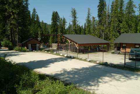
Colt Killed Camp
Colt Killed Camp
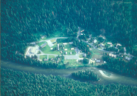
The location of Colt Killed camp is the present site of the Power Ranger Station complex on the Lochsa River. The journalists called the river here the “Koo koos ke” and “Flathead.”
The hunters had killed only a few grouse, “on which, without a miracle it was impossible to feed 30 hungry men and upwards, besides some Indians,” Patrick Gass complained. Captain Lewis offered the hungry men some portable soup, which was actually a seasoned beef or pork broth similar to bouillon, and correspondingly of limited nutritional worth. The obvious recourse to kill one of the colts they had purchased from Indians, “which they immediately did,” Gass added, “and set about roasting it; and which appeared to me to be good eating.” They must have restrained their appetites that night, for they had enough meat left over for breakfast the next morning. The party numbered 32 souls plus seven-month-old Jean Baptiste Charbonneau, who would have still been nursing at Sacagawea‘s breast, plus Toby and his two sons, and Lewis’s dog, Seaman.
The horses didn’t fare as well, for recent Indian encampments in the vicinity had consumed the last good grass of the season. The men put the horses on the island for the night, perhaps partly to discourage them from wandering off in search of food, even though the eating probably wasn’t much better over there.
It had been the roughest day to date. “The Mountains which we passed to day much worst than yesterday,” wrote Clark, “the last excessively bad & Thickly Strowed with falling timber . . . Steep & Stoney our men and horses much fatigued.” The obstacles notwithstanding, historian Ralph Space found evidence that the trail from the divide down to the Lochsa as far as Wendover Ridge had been used more than the rest of K’useyneiskit, by Indians from east of the divide in quest of salmon and steelhead trout.
That river’s Indian name, which the journalists evidently never heard, is Lochsa, meaning rough water. The “branch”–a small stream–no longer flows; its bed was obliterated during the expansion of the ranger station.
Rough Water
Rough Water
An unnamed Class II rapid on the Lochsa
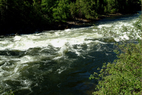
© 2005 VIAs Inc.
Why didn’t the Corps of Discovery just carve dugouts at their camp of 14 September 1805, and float down the river? We don’t know why they didn’t. If the idea even came up, none of the journalists mentioned it. Or if it did, maybe their Lemhi Shoshone guide dismissed it with an emphatic shake of his head, and Clark had learned enough from him over on the Salmon River to trust his judgment. Today, the answer can be read from the highway (U.S. 12) that follows the Lochsa’s narrow north bank for 63 miles between the mouth of the Brushy Fork and the entrance of the Selway River, where the two form the Middle Fork of the Clearwater. Here are the cold facts.
First, the riverbed is steep, so the water flows fast. It drops 1,960 feet in 64 miles, for an average of 31 feet per mile.[2]Before the first dam was built on the mainstem of the Missouri River, it dropped approximately 3,532 feet in 2546 miles, an average of 1.4 feet per mile. Second, at high-water time in May and June there are 63 rapids rated above Class II by experienced river-rafters. Forty-four of those are rated as major rapids in the range of Class III-IV,[3]here are six general classifications of river conditions, from a recreational perspective. Class I allows a placid, mostly hands-free drift; Class II, with occasional waves that may be as much as 3 … Continue reading and 40 of those—including “Snag, the Grim Reaper” and “Killer Fang Falls”—are in the central 24 miles of the river. It’s equally dangerous In late summer and early fall, when the river is at its lowest. The jagged rocks that produce the white water that some floaters find thrilling, can fray the best fiberglass kayak or shred the toughest rubber raft. Until the present highway was finished in the mid-1900s, there were many places where portages would have been impossible. Third, whereas most popular floaters’ rivers have long placid pools between rapids, this one often allows little recovery time between its thrills. The upper 23 miles, for example, has only about a dozen Class II-III rapids, with practically no intervening pools at all; that entire stretch is, in effect, one continuous rapid. Finally, there is the matter of water temperature, which in June through early July ranges between 40 and 55 degrees Fahrenheit, making hypothermia an immediate threat to anyone who falls in.
Countless Indian generations ago the people who knew this river gave it a simple name. Lewis and Clark, who first called it “Flathead River” and later “Koos koos ke,” apparently never heard it; maybe Toby hadn’t, either. Who knows? Coyote might have made it up. Factually true, yet tinged with the irony of understatement, it was Lochsa—say lock-saw.
It means “rough water.”
White Sand Fish Hatchery
© 2004 VIAs Inc.
White Sand Fish Hatchery is at the confluence of the Crooked Fork (Clark’s “North Fork”) and Pack Creek (Clark’s “Glade Creek”). It was constructed in 1988 as part of the Lower Snake River Compensation Plan, which had been initiated in the late 1970s after the completion of four dams on the Snake River.
The hatchery supplements the natural propagation of chinook salmon by collecting eggs and sperm (milt) from adults that come upriver to spawn. The eggs are fertilized and taken to the Clearwater Fish Hatchery near Orofino, where they are hatched. When the hatchlings reach fingerling size they are brought back to White Sand and acclimated in the large pond across the river from the hatchery, which they will “remember” as their birthplace. In due time they are released into the Lochsa and several nearby tributaries, where they join naturally-spawned chinooks on their journeys to the Pacific Ocean and back.


Colt Killed Creek Campsite is a High Potential Historic Site along the Lewis and Clark National Historic Trail managed by the U.S. National Park Service. This site is at the Powell Ranger Station in the Clearwater national Forest.—ed.
Notes
| ↑1 | Clark likely meant Brushy Fork, of which Glade Creek is a tributary |
|---|---|
| ↑2 | Before the first dam was built on the mainstem of the Missouri River, it dropped approximately 3,532 feet in 2546 miles, an average of 1.4 feet per mile. |
| ↑3 | here are six general classifications of river conditions, from a recreational perspective. Class I allows a placid, mostly hands-free drift; Class II, with occasional waves that may be as much as 3 or 4 feet high, requires firm and persistent control of the water craft; Class III requires a boatman who can cope with rocks, holes, eddies, and sudden drops, in unpredictable size and sequence; Class IV rapids are real soakers, representing the upper level on the “fun scale”; Class V is scary for the best boater because of turbulent currents, treacherous waves, holes and hidden obstacles; Class VI is off the charts, even for the experts, except during favorable river levels, which rarely occur. Generally, Class III and above are considered major rapids requiring intermediate to advanced whitewater floating experience and skill. These classifications, especially the higher ones, are subjective. Conditions may change within days or even hours. The descriptions of the recreational characteristics of this river have been drawn from Whitewater Floating Management Plan: Lochsa River, USDA Forest Service, Clearwater National Forest, c. 1984. |