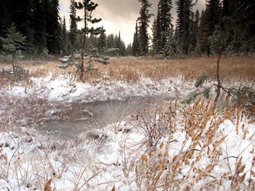
Private Whitehouse reported that on September 17 they “Camped at a Small branch on the mountain near a round deep Sinque hole full of water.”
Serpent Creek
Most of the party had nothing to do for the first six or seven hours on the seventeenth but stand around in the cold and wait for all their wandering horses to be found. After they got under way again, at one o’clock in the afternoon, they “passed over Several high ruged Knobs and Several dreans & Springs passing to the right, & passing on the ridge devideing the waters of two Small rivers.” One was perhaps Gravey, the other Serpent Creek. The road was “excessively bad,” and debilitating injuries to the horses were continual threats.
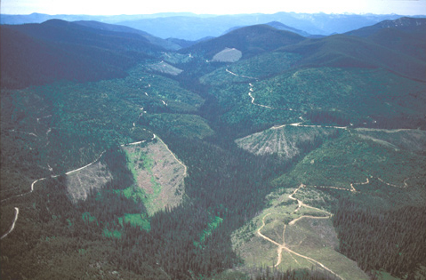
In the accompanying photo, forest access roads contour along the mountainsides above the creek, through old clearcuts identifiable by the medium green, and recent clearcuts identifiable by their gray-brown color. The vertical lines such as those at right of photo-center were made by dragging logs up to a road where they could be loaded on trucks. Many of the trees still covering the higher elevations are less merchantable species, including subalpine fir. Trees have not been harvested in the creek-bottoms in order to protect the riparian (streamside) habitat and preserve water quality.
Separating the nearer mountains from the hazy blue ridges in the distance is the Gravy Creek drainage, which flows northeast toward its confluence with Cayuse Creek, which feeds Kelly Creek, a tributary of the North Fork of the Clearwater River. (See Snow Bank Camp to Lonesome Cove).
Sinque Hole
Indian Grave Meadow
© 25 October 2009 by Kristopher Townsend. Permission to use granted under the Creative Commons Attribution-Share Alike 4.0 International license.
Indian Grave Meadow contains several small ‘sinque holes’ and is located between the traditional ‘Sinque Hole’ (see below) and the Smoking Place. The location has long served as a camping area for Indians, trappers, road builders, and hunters. Some trail researchers also believe this is where the expedition camped on the night of 17 September 1805.
“Our horses much Scattered,” Clark complained on September 17, “which detained us untill one oClock P. M.” On the previous day the hunters killed only a few grouse, “which was not Sufficient for our Supper which compelled us to kill something. a coalt being the most useless part of our Stock he fell a Prey to our appetites.” That night, Private Whitehouse explained, the mare whose colt they had eaten went looking for her offspring all the way back at the previous day’s “lonesome cove” camp, and four of the geldings (males) tagged along. A heavy wet snow fell the greater part of the day, and between that and the accumulated snow falling from the trees, they were soaking wet all afternoon. As if that weren’t enough, Whitehouse related that “the Snow melted So that the water Stood in the trail over our mockasons in Some places.”
Private Whitehouse reported that on September 17 they “Camped at a Small branch on the mountain near a round deep Sinque hole full of water.” There is more than one place in the vicinity that might meet that description, but this is the one that has been marked by the Clearwater National Forest along K’useyneiskit:
‘Sinque Hole’
360° panoramic photo
The Smoking Place, 1806
Smoking Place by Air
View southwest
© 2001 Airphoto, Jim Wark. All rights reserved.
They pushed hard on June 27, covering an estimated 28 miles “without releiving the horses from their packs or their having any food.” About three hours into the day’s travel their Indian guides requested a smoking break at a conic landmark of stones piled six to eight feet high topped with a fifteen-foot pine pole. The monument had a practical purpose. “From hence,” wrote Clark, “they informed us that when passing over with their familes some of the men were usually sent on foot by the fishery at the entrance of Colt Creek in order to take fish and again met the main party at the Quawmash glade on the head of the Kooskooske river.”
The captains were duly impressed with their pilots’ ability to find the road wherever the snow had melted, even if was for a short interval. Then, ” after smoking the pipe and contemplating this seene sufficient to have damp the sperits of any except such hardy travellers as we have become, we continued our march.”
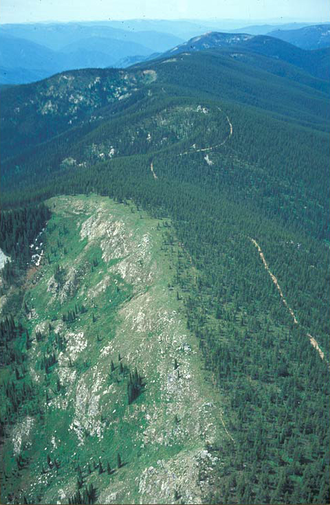
The white line etched in the tree-scape is the Lolo Motorway, built by the Civilian Conservation Corps in the 1930s. It generally parallels, and sometimes coincides with, the ancient Nez Perce “road” called K’useyneiskit.
It was a memorable moment for the Corps as well. From this place, Clark recounted:
we had an extensive view of these stupendous mountains principally covered with snow like that on which we stood; we were entirely surrounded by those mountains from which to one unacquainted with them it would have seemed impossible ever to have escaped; in short without the assistance of our guides I doubt much whether we who had once passed them could find our way to Travellers rest in their present situation for the marked trees on which we had placed considerable reliance are much fewer and more difficult to find than we had apprehended.


Smoking Place is a High Potential Historic Site along the Lewis and Clark National Historic Trail managed by the U.S. National Park Service. The site is in the Nez Perce-Clearwater National Forest and part of the Lolo Trail National Historic Landmark.—ed.