Clark produced this map of Lewis’s route on the Road to the Buffalo sometime after the Corps was reunited on 12 August 1806, near today’s New Town, North Dakota.
Travelers’ Rest to the Sun River
To see labels, point to the map.
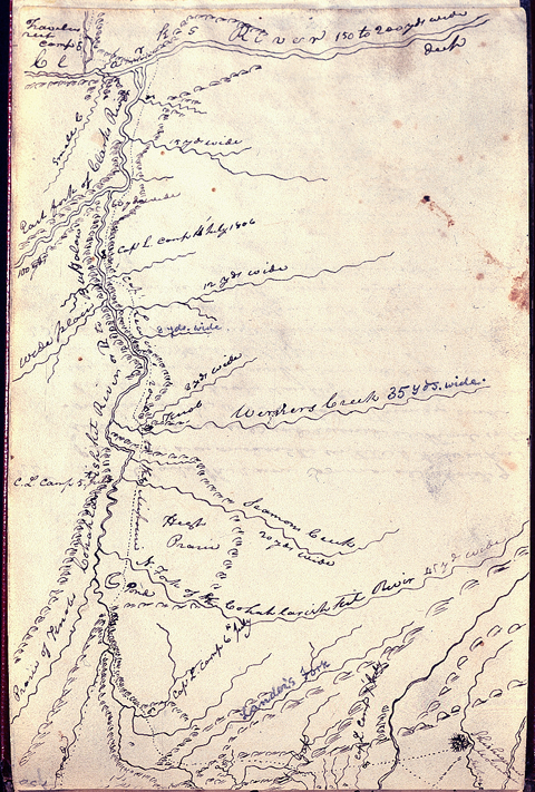
Codex N, p. 150, American Philosophical Society, Philadelphia.
See also Travelers’ Rest and Down the Sun River.
Rocky Mountain Front to White Bear Islands
To see labels, point to the map.
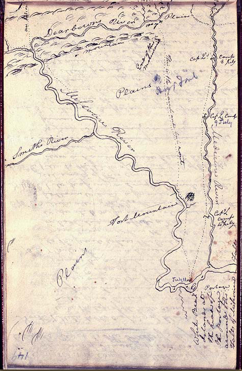
Codex N, p. 149, American Philosophical Society, Philadelphia.
Lewis named “Werners Creek” for William Werner, of whom little is known either before or after the expedition. The captains had named a small tributary of the Missouri after him earlier, at the mouth of which they had camped on 9 May 1805. He volunteered to accompany Lewis on the exploration of Maria’s River, but was dropped from that detail after 10 of the detachment’s 17 horses were stolen at White Bear Islands during the night of July 11, and Lewis was compelled to reduce the size of his party from eight to three. Otherwise, aside from two minor disciplinary problems early in the expedition, Werner did not earn much notice in the journals.
The words “Landers Fork” were penciled in by Elliott Coues in 1892. Frederick Lander was a surveyor with Isaac Stevens’ 1853-55 expedition to locate a viable railroad route from St. Paul, Minnesota, to the Pacific Northwest.[1]Isaac Stevens, Narrative and Final Report of Explorations for a Route for a Pacific Railroad near the Forty-Seventh and Forty-ninth Parallels of North Latitude, from St. Paul to Puget Sound (12 vols, … Continue reading
The “wide place” upstream from Lewis’s campsite of 4 July 1806 is the Potomac Valley where, some seventy-five years after Lewis passed by, a farmer from Virginia started a town in that grew into a stage station boasting two hotels, three saloons, a post office, church, school, and general store. Nostalgically, he named it after the stream he had known back home in the Piedmont—the Potomac River.
Notes
| ↑1 | Isaac Stevens, Narrative and Final Report of Explorations for a Route for a Pacific Railroad near the Forty-Seventh and Forty-ninth Parallels of North Latitude, from St. Paul to Puget Sound (12 vols, Washington, D.C: House of Representatives, 1855), vol. XII, book I. |
|---|