Good Comfortable Road
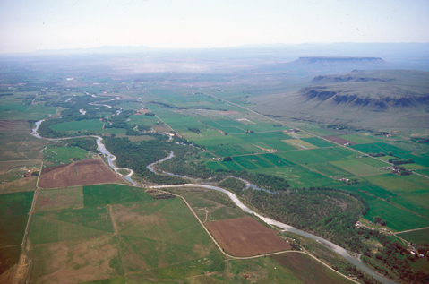
Sun River and Two Battle Hills
View east
To see labels, point to the photo.
© 2002 Airphoto, Jim Wark. All rights reserved.
Except for the fence lines and lanes, the crisp margins where the river bottoms meet the fields, and the kaleidoscope of greens and browns telling tales of landowners’ lives and fortunes, this was the scene Lewis and his detachment awoke to on the morning of 10 July 1806: the pre-dawn light glinting in the river, the blue-gray haze left over from the preceding day’s cold rain, and the misty outlines of two Indian landmarks rising above the plains. Although he had seen the farther one—which he and Clark had dubbed “Fort Mountain”—from the Missouri River on 15 July 1805, and although he had acknowledged seeing it from the pass on the recent 7 July 1806, he made no mention of it on this date.
Having crossed the Rocky Mountains the previous day, 9 July 1806, proved to be a rainy day. With familiar landmarks in sight, they headed towards the Great Falls of the Missouri River. Some old Indian lodges afforded temporary shelter from the rain. Joe Field killed a fat buffalo bull just in time for their midday meal, and they stopped to feast on it. With no sign of a letup in the cold rain, Lewis decided to camp there for the day, at the mouth of today’s Simms Creek, having covered only eight miles since dawn.
Beyond Crown Butte, Shaw Butte, and Square Butte (Fort Mountain) and even further than the Belt Mountains, the Highwood Mountains were again in view. These were the snow-capped peaks Lewis and Clark spotted from a hilltop at the mouth of Cow Creek (their “Windsor Creek”) on the Missouri River, on 26 May 1805. Unaware he was looking at an island range of volcanic origin that is situated nearly 100 miles east of the Rocky Mountain Front, Lewis exulted,
whilst I viewed those mountains I felt a secret pleasure in finding myself so near the head of the heretofore conceived boundless Missouri; but when I reflected on the difficulties which this snowey barrier would most probably throw in my way to the Pacific, and the sufferings and hardships of my self and party in them, it in Some measure counterballanced the joy I had felt in the first moments in which I gazed on them; but as I have always held it a crime to anticipate evils I will believe it a good comfortable road untill I am compelled to believe differently.
Now, almost exactly a year later, with a long, hard road between, Meriwether Lewis has tempted fate and his “chapter of accidents” again by re-entering the domain of the people he had repeatedly been advised to steer clear of—the Blackfeet, Siksikas, Atsinas, and Assiniboines. He has good reason to expect just such an “accedental interview” as he was to have only seventeen sleeps hence, on the morning of 17 July 1806. Meanwhile, he and his companions—all “of courage undaunted,” as Jefferson was later to write of Lewis—scan the horizon ’round from pre-dawn to twilight, and tune their ears to every sound in the night, while traversing this “good Comfortable road.”
The “Battle Hills”
“Battle Hills”
To see labels, point to the image.
© 2002 Airphoto, Jim Wark. All rights reserved.
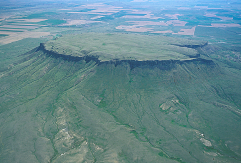
Square Butte
View Northeast
© 2002 Airphoto, Jim Wark. All rights reserved.
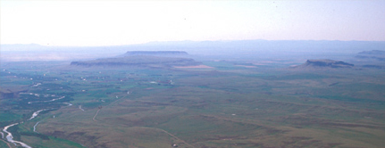
Square, Shaw, and Crown Buttes are believed to be the landmarks Old Swan had in mind when he told Peter Fidler about the “Battle Hills,” and showed him where to place them on his map. Square Butte, currently owned by a private landholder, was one of the major landmarks Lewis and Clark recorded in this vicinity, naming it “fort mountain.” Shaw Butte is two and one-half miles southwest of the village of Fort Shaw, which originated as a military post established in 1867. The fort was authorized by Congress in 1865 and named in honor of Colonel Robert G. Shaw, a Bostonian who commanded one of the first two volunteer Black infantry regiments during the Civil War. The heights of Shaw Butte, reaching more than 1,000 feet above the Sun River Valley floor, include a privately owned 640-acre privately cattle ranch. The third of the “battle hills” is Crown Butte, which is out of the photo to the right. Rising 900 feet above the prairie, it is owned and managed as a natural preserve by the Nature Conservancy.
Shortly after leaving their upper canoe camp in mid-July of 1805, both captains took note of “a round mountain on our right abt. 10 miles appears inaxcessable.” They called it “fort mountain.” Shaw and Crown Buttes are also flat-topped buttes in the immediate vicinity, but they were not visible from the Missouri River.
Square Butte’s straight vertical battlements and the panoramic view from its brink justify the Lewis and Clark naming the landmark Fort Mountain. Countless generations of Indian people had already seen it as an “inaxcessable,” safe retreat too, and thought of this and the other two prominent buttes as “Battle Hills.” The treeless heights of both Square Butte and Crown Butte are indeed inaccessible by wheeled machinery such as plows and combines, so they remain among the few pristine islands of the mixed prairie that once covered the arid high plains.
How this landmark came to be called Square Butte is not known for sure. Before the advent of aerial photography it may have seemed more square when viewed from the valley, especially its east face, than either Shaw Butte or Crown Butte. But the geometrical distinction is relatively unimportant, compared with the story of the geological events that created these and many other similar formations in this vicinity. The three laccoliths in this famous group were not all created at the same time. Shaw Butte has more rounded edges than the other two because it still has more of its original sedimentary cover, which indicates it is the youngest.[1]David Alt and Donald W. Hyndman, Roadside Geology of Montana (Missoula, Montana: Mountain Press, 1986), 351-55. Shonkinite is a dark igneous rock consisting of augite, a dark silicate mineral … Continue reading
Haystack Butte—Lewis’s “—Shishequaw Mountain”—was formed by the same processes at about the same time, give or take a few million years. Clearly, however, conditions in the sandstone layer at that place created a laccolith of a different, though equally distinctive, shape.
The Big Belt Mountains
During the Jurassic Period of the Mesozoic Era, 50 million years ago, a shallow inland sea stretched westward from the slowly rising Rocky Mountains. A hundred miles or so out in that sea was a somewhat arid coastal plain that was to become an “island range” of mountains. In due time, layers of sand and mud compressed beds of peat—rotting vegetable matter—into coal. A few million years later a conspicuous sandstone ledge was deposited there, which eventually gave the name Belt to the range of mountains that eventually emerged. The creek that Lewis and Clark called Portage Creek emptied into the Missouri near the lower portage camp, and is now called Belt Creek, rises in those mountains. The lofty cliffs that border the east side of the Gates of the Mountains were part of the Big Belts’ western limits. From the 1890s to the 1950s that layer of compressed Jurassic peat was mined for coal to power railroad locomotives and the copper smelter at Great Falls.
Rectangular Survey System
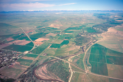
9 July 1806 Campsite
View west
To see labels, point to the photo.
© 2002 Airphoto, Jim Wark. All rights reserved.
Flowerree Butte: Daniel A. G. Floweree, a native of Missouri, left the California gold fields and moved to Helena, Montana in 1865. There he lucked onto a profitable lode, and used the money to establish the first cattle ranch in the Sun River Valley. By 1880 the Flowerree operation was running somewhere between 25,000 and 40,000 head of cattle on the free open range. The deep snow and bitter cold of the winter of 1881, followed by the even worse winter of ’86, spelled the end of the open range. Thereafter, cattle were fenced in and fed hay during winter months.
Simms: Two brothers named Simms once cut firewood along the creek where they lived, to sell to nearby settlers. The town (pop. 373 in 2000), begun in 1908, was the administrative center of the Sun River Irrigation Project, one of the first in the nation to be established after President Theodore Roosevelt signed the Reclamation Act in 1906. The irrigation project was designed to convey water from numerous man-made reservoirs to hayfields in the valley throughout the summer, supplementing the modest 10 to 14 inches of annual precipitation which is effectively diminished by the high winds and low humidity in the lee of the Rocky Mountain Front. At the turn of the 21st century, a long dought that may have been exacerbated by global warming made water even more scarce in Sun River country.[2]A Pictorial History of the Sun River Valley (Shelby, Montana: Promoter Publishing, 1989), 41-51, 176-82.
The geometric grid imprinted on the valley floor in the two photos above tells a story: It was not the Lewis and Clark expedition that opened and changed the west, it was the imprint of Thomas Jefferson‘s intellect as reflected in the concept of land measurement and ownership which he espoused. “This is surely an age of innovation,” wrote Jefferson to a friend in 1784, “and America the focus of it.”[3]Jefferson to Francis Hopkinson, 3 May 1784. Papers of Thomas Jefferson, 7:205.
One of the key questions confronting the Continental Congress of 1784 was how to measure and dispose of land added to the national— i.e., public—domain through treaties with Indian nations. Southern states traditionally recognized an owner’s claim to land defined by the centuries-old principle of metes and bounds—markers and lines that enclosed the land best for farming, and excluded the worst, such as untillable slopes or marshes. That policy worked well enough in small, stable communities, but in a new nation on the eastern fringe of a vast continent of unknown value, it was thoroughly impractical. As a record of ownership it was subjective and arbitrary, often difficult for a third party to confirm, and impermanent in the long run.[4]William D. Pattison, “Beginnings of he American Rectangular Land Survey System, 1784-1800.” (Ph.D. Dissertation, University of Chicago, 1957). For example, the daily “courses and distances” Lewis and Clark recorded to describe their route through the Northwest was essentially an incomplete metes-and-bounds survey; it was never closed and proved—brought back to the starting point—in order to define a parcel of land. One of the reasons it is difficult to retrace the expedition’s route today is that most of the objects such as trees and bends in the river that they chose as metes or markers to define the beginning and end of each course, are gone. Trees have died, or the river channel has moved by miles, perhaps, in one direction or another.
As a Congressman from Virginia, Jefferson was appointed chairman of the committee on public lands and charged with the task of working out an alternative to metes-and-bounds surveys. His concept, partly based on British precedents, was ultimately refined into the American rectangular survey system, which has been basic to land ownership, administration, and management. It is objective, orderly, verifiable, and permanent. The office of Surveyor General was established by Congress in 1796, but it was not until 11 February 1805, that Congress wrote the new system into law under Title 43 of the United States Code.
It begins with the cardinal points of the compass, True North, South, East, and West. As each new territory or state has been added to the public domain, a Principal Meridian has been designated by authority of the Surveyor General and the Government Land Office to serve as a starting point for surveying. The land is surveyed into rectangular Townships measuring six miles square, or 36 square miles. Every square mile is divided into 36 rectangular Sections of 640 acres. Each Section is divided into four 160-acre quarters, and so on down to the smallest practical unit, the “lot.” All boundaries, from the Township on down, run north-south and east-west. Every place is defined by four right-angle corners.
In the Act of 28 February 1806, the Surveyor General was directed to begin surveying the entire Territory of Louisiana. The deputy surveyors’ first jobs were to reconcile the private land claims established under French and Spanish authority with the new system.[5]C. Albert White, A History of the Rectangular Survey System (Washington, D.C.: United States Department of the Interior, Bureau of Land Management, 1983), 54-58.
By authority of the Surveyor General the Principal Meridian, or surveyor’s baseline, for Montana Territory was set in 1867 at 45 degrees 47 minutes 13 seconds North (of the equator) Latitude and (as appropriately abbreviated) 111°39’33” West (of Greenwich, England) Longitude. In real terms, that point is located about ten miles southwest of Three Forks and about three miles southwest of the settlement of Willow Creek, near the Jefferson River. All of the lines outlining the fields in these photos were determined by surveys that started at that Principal Meridian.
The fundamental contrast between the official U.S. rectangular survey system as reflected in the geometric patterns of these farms in the Sun River valley, and the Indian sense of the comparatively chaotic shapes in a sort of natural “metes-and-bounds” definition of territories, lay at the root of the conflicts between the U.S. and the Indian nations, and between emigrants and Indians, for more than a century after Jefferson broached his plan to simplify and standardize a way of defining place.
Two hundred years later, the Global Positioning System has made it obvious to nearly everyone: Wherever we are, we’re in a corner.
Notes
| ↑1 | David Alt and Donald W. Hyndman, Roadside Geology of Montana (Missoula, Montana: Mountain Press, 1986), 351-55. Shonkinite is a dark igneous rock consisting of augite, a dark silicate mineral compound containing iron and magnesium, plus white or pink crystals of potassium feldspar. It is similar to the basalt that can be seen as outcrops of the Idaho batholith around Lolo Hot Springs, but it contains more potassium than basalt does. |
|---|---|
| ↑2 | A Pictorial History of the Sun River Valley (Shelby, Montana: Promoter Publishing, 1989), 41-51, 176-82. |
| ↑3 | Jefferson to Francis Hopkinson, 3 May 1784. Papers of Thomas Jefferson, 7:205. |
| ↑4 | William D. Pattison, “Beginnings of he American Rectangular Land Survey System, 1784-1800.” (Ph.D. Dissertation, University of Chicago, 1957). |
| ↑5 | C. Albert White, A History of the Rectangular Survey System (Washington, D.C.: United States Department of the Interior, Bureau of Land Management, 1983), 54-58. |