To return to the portage of the Great Falls of the Missouri, Lewis would take a shortcut following a good Indian road, the Road to the Buffalo. First, he would need to pass through Hell’s Gate, a canyon where Blackfeet often ambushed travelers.
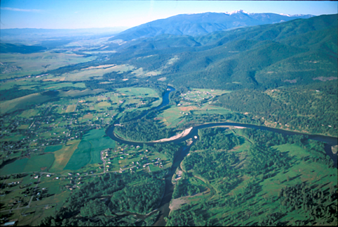
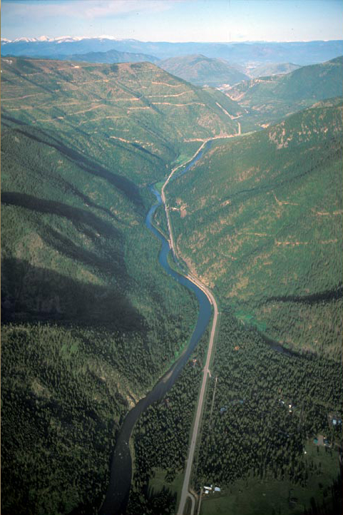
Confluence Bitterroot and Clark Fork
View south
To see labels, point to the image.
© 2003 Airphoto, Jim Wark. All rights reserved.
This view looks south from the confluence of the Clark Fork of the Columbia (lower center and right of center) with the Bitterroot River. The campsite of Travelers’ Rest is at the mouth of the canyon on the north side of Lolo Peak. Lewis and his party followed the Indian road from there along the foot of the mountain to the confluence of the Bitterroot and the Clark Fork. On the horizon at upper right is the snow-covered Lolo Peak—actually two peaks on the same mountain. The nearer mountain, at right, for reasons uncertain, is today called Blue Mountain. Perhaps that was a synonym for “purple mountains’ majesty” in the familiar patriotic hymn.
An Excellent Road
In an undated document, Clark reported: “The Indians inform us that there is an excellent road from the 3 forks of the Missouri through a low gap in the mountains to the East fork of Clarks river which passes down that fork to its junction and up on the West Side of the main fork to Travellers rest Creek which they travel with their families in 6 days.”[1]Moulton, “Postexpeditionary Miscellany,” 8:394. Having observed that Indian bands generally travelled about 25 miles per day, he estimated the distance to be about 150 miles.[2]The word “mile” is a Middle English contraction of the Latin expression milia passum, which denoted a thousand double paces. The highways that today parallel those ancient Indian trails from the Three Forks of the Missouri to the present Travelers’ Rest State Park via Clark’s “low gap in the mountains,” cover about 185 miles (218 Km), which can be driven in three hours at the posted speeds.
The road up the “East Fork Clark’s River” was, Lewis noted on 9 September 1805, “a good rout to the Missouri which the Indians say may be traveled in 4 days.” But it led circuitously southeast to the Three Forks (as does Interstate 90 today), whereas Lewis was headed northeast, toward the Great Falls of the Missouri, where some of his men would prepare for the portage, which would be completed when Sergeant Ordway and his detail arrived from Fortunate Camp with the canoes.
Clark Fork Crossing
Confluence Bitterroot and Clark Fork
View southwest
To see labels, point to the image.

© 2003 Airphoto, Jim Wark. All rights reserved.
Inscribed on the land are the two rivers’ memories of their long-past meetings, channels long since abandoned amid the chaos of riverine dynamics. Cottonwood trees owe their lives to rivers. Since their seeds take root and thrive at the margins of a river’s maximum seasonal width, their orderly rows record the ups and downs of water levels within that century. Having a life expectancy of 80 to 100 years, they are the continuous, sweet-scented mementos of only the past century.
Leaving Clark and Travelers’ Rest behind, Lewis departed on 3 July 1806 for the Great Falls. After following the Bitterroot River seven miles north, he and his Indian guides arrived at an “East branch” of the river. Lewis and Clark regarded the Bitterroot as the main stem of “Clark’s River,” and so-named it. By the middle of the 19th century further exploration determined that Lewis’s “East Fork of Clark’s River” was actually the main stem, being 30 miles longer than either the Bitterroot or the Big Blackfoot.
At the recommendation of his Nez Perce guides, the rivers should be crossed at the confluence. Lewis described the river as “rapid and 150 yds. wide.” Swimming the horses, men, and Indian cargo would be relatively easy, but not so of the Corp’s cargo. Lewis constructed three small rafts, and by 3:00 that afternoon, they started ferrying the baggage. After several successful crossings and re-crossings, the rafts were becomming waterlogged. On the last ferry, Lewis lost control of his raft and they descended one and half miles before reaching the far shore.
Now evening, the wet men and mostly dry baggage headed east up the north shore of the Clark Fork. At sunset, they set up camp on a “small Creek,” today’s Grant Creek in the Missoula Valley. The first settlement in the Missoula Valley began in 1860 on Mullan’s Road in the vicinity of Lewis’s creekside campsite of 3 July 1806. In 1864 Hellgate Village moved a few miles up the Clark Fork, encouraged by the influx of travelers headed for the gold fields around Willard’s Creek over in the Big Hole. The new location centered on two mills built to satisfy the immediate needs of any prospective town–in those days, lumber and grain. Its new name was Missoula, a corruption of the Salish Indian placename phonetically written Nemissoolatakoo, and meaning “place of rushing waters.”
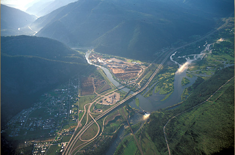
Hell’s Gate
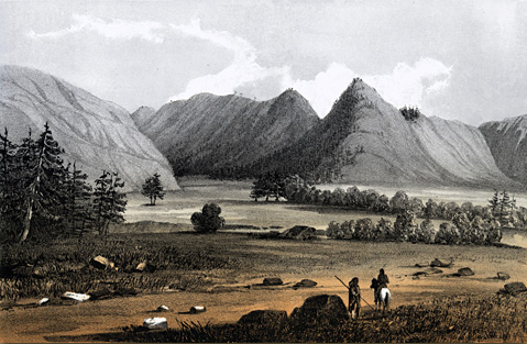
John Mix Stanley, one of the two artists (the other was Gustavus Sohon) who were members of Isaac Stevens’ expedition to find a potential railroad route to the Pacific[3]Watercolor paintings by Stanley and Sohon, totalling 70 in all, provided a more extensive visual account of the Northwest than had previously been published. They appeared in Volume 12 of the … Continue reading, here presents a view of Hell’s Gate, once known by the French equivalent Port d’Enfer, looking east from Hell Gate Ronde. The French word “ronde” in this context is synonymous with the English word “hole” as applied to a broad, flat valley hemmed in by mountains. The French names for this place were dropped well before the close of the 19th century. In reality, the sharp peak at right, now called Mount Sentinel, is not that sharp, and the mountain to the left of the canyon, long known as Mount Jumbo, is lower and less rugged than Stanley shows it. Mount Sentinel and the adjoining mountains constitute the northern terminus of the Sapphire Range; Mount Jumbo is the south end of the Rattlesnake Mountains, which are extensions of the Mission Range.
Cadotte’s Pass got its name from Jean-Baptiste Cadotte, a French-Canadian trapper and interpreter who was a partner of fur trader Alexander Henry the Elder (1739-1834). This gap is three and one-half miles south-southeast of the one Lewis crossed, and two miles north-northwest of Rogers Pass, where U.S. Highway 200 goes over the Continental Divide. All three passes are roughly 100 miles from Hell Gate canyon. Thus Stanley’s title for his painting reflects the Stevens party’s decision that Cadotte’s Pass would be the preferred route for a railroad through this part of the Rockies. Ultimately, the Northern Pacific Railway, which was completed in 1883, followed the Indian Road along the “East Fork of Clark’s River” after crossing the Divide at Homestake Pass. All three gaps are somewhat over 6,000 feet in elevation.
Indeed, in terms of scenic grandeur, the mountains like these that surround the Clark Fork Valley do not fit the image most people have in mind for “real mountains.” They don’t display the magnificence of Glacier National Park, the Grand Tetons, or the craggiest summits in Colorado or Canada. The many ranges that make up the Rocky Mountains between the 45th and 48th parallels are not as high as those others, but they’re just as steep, overall, and that’s what counts, and the rivers and streams that drain them and separate them have served to define the practical travel routes that penetrate them.
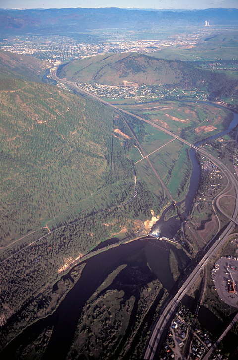
Ambush Alley
Hell’s Gate
View west
© 2003 Airphoto, Jim Wark. All rights reserved.
At the bottom of this photo the Blackfoot River (right) slips under Interstate 90 and contributes its waters—on this day slightly muddy with spring runoff from the mountain snows on the Continental Divide—to the “East fork of Clark’s river” (now called the Clark Fork of the Columbia). After tumbling over a hundred-year-old dam the river tests the resistance of a mountain spur known as Mount Jumbo (photo center), then squeezes through the “narrow confined pass” known as Hellgate Canyon–”port d’enfer,” as French-Canadian traders called it, because of its notoriety as a place where the “Pahkees”–Shoshone for “enemies” frequently ambushed Shoshone, Flatheads and Pend d’Oreilles, and Nez Perce hunting parties bound for buffalo country.
In the photo above, the uneven light lines on the mountainside at left are narrow gravel roads that were built for trucks to haul logs to a lumber mill. The forests here have been thinned by loggers several times since the late 19th century.
Beyond Hell’s Gate the Clark Fork arches toward the southwest across the “valley plain,” as Lewis called it, to join the Bitterroot River among the cottonwoods at extreme upper left.
French-Canadian fur trappers and traders passing through the valley around 1850 called it Hell Gate Ronde–rond is a French word for a broad level valley hemmed in by mountains, commonly called a “hole” by contemporary Americans.
Mullan’s Road
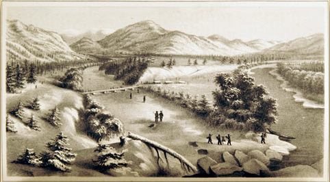
Confluence, Blackfoot and Clark’s Fork Rivers, 1863
Cantonment Wright
Capt. Mullan’s Winter Quarters in 1861-62
by Gustavus Sohon (1825–1903)
Special Collections, Mansfield Library, The University of Montana, Missoula.
The first highway through Hell Gate Ronde was a federal wagon road built in 1858-62 to facilitate communication, troop movements, and general travel between Walla Walla, the easternmost trading post west of the Rockies, and Fort Benton, the head of navigation on the Missouri. The 633-mile route was designated Mullan’s Road, after Captain John Mullan, the topographical engineer who surveyed and engineered it, and supervised its construction. Gustavus Sohon (1825-1903) was Mullan’s interpreter, guide, artist, and illustrator.
Sohon recorded the scene at the meeting of the Big Blackfoot River (left) and the upper Clark’s Fork of the Columbia (right) at the beginning of the coldest winter the local Indians could remember. The Blackfoot was completely frozen over, the Clark’s Fork fringed by thick ice. First, the men built several log huts, which Mullan named Cantonment Wright after his commanding officer, George Wright. The river ice, soon thick enough to support horses, enabled the sinking of stone piers to support a four-span, 235-foot wagon bridge–the first in the far West. The bridge was completed by the first of March, well before the next spring freshet began to rise.[4]Report on the construction of a military road from Fort Walla-Walla to Fort Benton, (Washington: Government Printing Office, 1863), 33. In the years following, it was frequently damaged by spring floods, and as a result its utility was relatively short-lived. Meanwhile, Indian people in the region must have looked upon it as an amazing leap in transportation, compared with their ages-old modes of crossing rivers.
The Blackfoot River
Blackfoot River
To see labels, point to the image.
© 2003 Airphoto, Jim Wark. All rights reserved.
The lines on the steep mountainsides are logging roads. Most are on property owned by lumber companies, and most are permanently closed after timber harvesting is done. The mountain to the left of the river has been logged more recently than the one on the right. With a yearly average of only 12 to 15 inches of precipitation, this is semi-arid country, so regrowth is slow in this part of the Rockies.
Four miles from their July third campsite on Grant Creek they arrived at the mouth of today’s Blackfoot River, which was paralleled by the trail the Nez Perce Indians called, according to the captains, Cokahlah-ishkit”—the “Road to the Buffalo.”[5]The Nez Perce word for “Road to the Buffalo” is properly transliterated into Ooq’ aalx’ Iskit. Lewis discovered the river to be “60 yds. wide deep and rapid.” It was, he continued, “not navigable in consequence of the obstruction of rocks and rapids &c.” Those impediments are but faintly discernible in this photo, which was taken early in May when the river was at its seasonal peak level.
Lewis described water of the “East fork” and the Cokahlahishkit–the “river of the road to the buffaloe”–as “terbid but the East branch much the most so; their beds are composed of sand and gravel; the East fork [Clark’s Fork] possesses a large portion of the former” (and the slipperiest round rocks that ever dunked a fly fisherman). Neither was navigable, he added, “in consequence of the rapids and shoals which obstruct their currents.” One of those rapids formed the foundation for the 21-foot-high dam, completed in 1908 and known as the Milltown Dam, Milltown being a long-time lumber processing center for the logging industry in the Blackfoot River drainage.
The party proceeded eight miles along the north bank to a “handsom bottom on the river where there was an abundance of excelence grass for our horses.” Remarkably, and for a change, there were no mosquitoes.
En route that afternoon Lewis added the skins of two squirrels to his collection. One was “of the speceis common to the Rocky Mountains,” which was Richardson’s ground squirrel. The identity of the other is not known.
If Lewis and his companions paid any special notice to the patriotic holiday, neither the captain nor Sergeant Gass mentioned it in their journals.
Milltown
The Big Blackfoot meets the Clark Fork
To see labels, point to the image.
© 2003 Airphoto, Jim Wark. All rights reserved.
The Indian road Lewis was following led him through West Riverside, around the toe of the ridge across the river from the plywood plant, and along the narrow north bank of the Big Blackfoot—”Cokahla rishkit, the river of the road to buffaloe.”
The Milltown Dam, built in 1908, identifiable by its frothy spillway at lower center, has become the largest Superfund site in the U.S., owing to the century-long buildup of silt, laden with toxic waste—arsenic, lead and mercury— from copper mines and smelters 180 miles up the Clark Fork.
During the past century the Milltown Dam has impounded 6.6 million cubic yards of upstream sediment, including about 2 million yards of heavy metals–arsenic, copper, zinc, iron, and manganese–from the mines and smelters of Butte and Anaconda, on the west slope of the Continental Divide, 125 river miles to the east. In 1982 sanitation engineers, responding to complaints from local residents, found arsenic in the drinking water of Milltown, the small community at lower right in the above photo. Soon a coalition of concerned citizens and local officials set in motion an intense effort to remove the antiquated dam, haul away the contaminated sediment behind it, and not only improve the quality of the aquifer but also restore the endangered bull trout to their native habitats in the Big Blackfoot and upper Clark Fork Rivers.
In this view, looking east, the Clark Fork of the Columbia flows from upper right toward lower center. The Big Blackfoot—so-called to distinguish it from the Little Blackfoot River, which joins the Clark Fork 40 miles upriver from here—flows from upper left to meet the Clark Fork between West Riverside (lower left) and Milltown-Bonner (center). The valley here is dominated by the plywood plant east of the river, which began on that location in 1911, when logs harvested 30 to 50 miles up the Big Blackfoot canyon were floated down to the mill annually on the spring freshet.
On 17 October 2005, the removal was begun of the 30-foot high timber crib dam on the Blackfoot, built in 1886 as a terminus for the annual log drives from upriver (invisible in this photo because submerged by water behind the Milltown Dam). The Milltown Dam was breached in March 2008, and its removal was complete by the end of that year. The entire reclamation and restoration project was initially scheduled for completion sometime in 2011, but the discovery of a significant amount of submerged but still valuable lumber, among other impediments, delayed the conclusion of the reclamation and restoration until 2014.
Notes
| ↑1 | Moulton, “Postexpeditionary Miscellany,” 8:394. |
|---|---|
| ↑2 | The word “mile” is a Middle English contraction of the Latin expression milia passum, which denoted a thousand double paces. |
| ↑3 | Watercolor paintings by Stanley and Sohon, totalling 70 in all, provided a more extensive visual account of the Northwest than had previously been published. They appeared in Volume 12 of the Narrative and Final Report of Explorations for a Route for a Pacific Railroad near the Forty-Seventh and Forty-Ninth Parallels of North Latitude, from St. Paul to Puget Sound (12 vols. in 13, Washington, D.C.: 1855). The forty-fifth parallel is about 100 miles north of Travelers’ Rest; the forty-ninth parallel marks the boundary between the U.S. and Canada in this part of the continent. |
| ↑4 | Report on the construction of a military road from Fort Walla-Walla to Fort Benton, (Washington: Government Printing Office, 1863), 33. |
| ↑5 | The Nez Perce word for “Road to the Buffalo” is properly transliterated into Ooq’ aalx’ Iskit. |