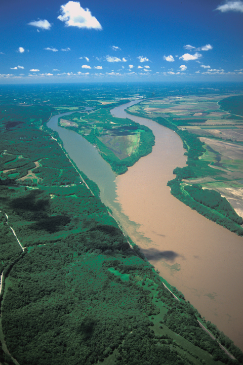
This view of the confluence of the Osage and Missouri Rivers was photographed in May 2000 while the annual spring runoff was still in progress. Fifteen dams—the first of them 680 miles upriver at Yankton, South Dakota—control floods and arrest some of the silt and sediment brought to it by hundreds of tributaries, great and small.[1]The first dam was completed in 1891, the last in 1966. The hemming in of the channel with levees deepens it for river commerce, and reserves the sandy soil of the bottomlands for agriculture. (Notice the old riverbank at extreme right. The floodplain here 200 years ago was a mile or more wider than it is today.) Nevertheless, the Missouri continues to deserve its nickname. The comparatively clear water of the Osage scarcely compromises “The Big Muddy.”
At four in the afternoon of 1 June 1804, the expedition arrived at the mouth of the Osage River, one of the major Indian trail intersections on the lower Missouri. From the height on the point, which may have been nearly four miles west and two miles south of the location shown here, Clark wrote: “I had a delightfull prospect of the Missouries up & down, also the Osage R. up.”
That night and the next morning Lewis took celestial observations to measure the latitude and longitude of the place. The figures representing longitude would be referred to a mathematician after the expedition, but the latitude, easier to compute, was quite accurately determined as North 38°31’6.9″. Meanwhile, Clark measured the widths of the Missouri—875 yards—and Osage—397 yards—at the point of convergence, and the width of the neck of land upstream from the point, just for the record. In the afternoon of 3 June 1804 Lewis took a short walk up the Osage and back before the party proceeded on to the night’s camp at the mouth of the Moreau River.
None of the journalists mentioned the Osage Indians, who were known to live near the three forks of the Osage River, more than 100 miles upstream from the Missouri. (beyond today’s Lake of the Ozarks behind Bagnell Dam). However, by the following winter at Fort Mandan the captains had accumulated enough intelligence about more than fifty Indian tribes to write a description of each, using an outline of nineteen different topics. The explorers recorded the respective tribes’ names for themselves, with phonetic transliterations carefully spelled out. They paid attention to linguistic connections among the nations. They noted each tribe’s customary homelands, and market-places. They calculated the prospects for fitting each into the larger trade network of the West.[2]Moulton, Journals, 3:386-450. The Grand Osages were first on their list; the Little Osages second.
Clark’s 1805 Map
The ‘Ossage’ River
From Clark’s Map of 1805
To see labels, point to the image.
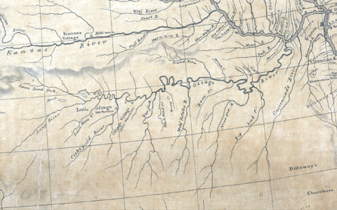
Map Division, Library of Congress.
During the winter of 1804-05 at Fort Mandan, Clark drew “A Map of part of the Continent of North America. Between the 35th and 51st degrees of North Latitude, and extending from 89° Degrees of West Longitude to the Pacific Ocean: Compiled from the Authorities of the best informed travellers by M. Lewis.”[3]Ibid., Atlas, Map 32a. The chart of the “Ossage River” it contained evidently was copied from the captains’ 1804 map of the “Territory of the Ozages.”[4]Ibid., Atlas, Map 6. Lewis also spelled the name “Osarges” on his 1804 map. Earlier charts kept the French spelling, Ausages. Chief among those informants were Auguste Chouteau and his younger half-brother Pierre, who had been trading with the Osages since the early 1770s. The only old name of a tributary remaining on present-day maps is Niangua.
1806 Return
The Corps of Discovery passed the Osage River again on 20 September 1806 without comment. That’s understandable, for their hearts and minds were preoccupied with more momentous thoughts and feelings: St. Louis was just three days away!


Clark’s Hill State Historic Site provides public access to a “viewing platform over the rocky outcop that Clark stood upon” to view the Osage and Missouri confluence and is a High Potential Historic Site along the Lewis and Clark National Historic Trail managed by the U.S. National Park Service.—ed.