The Three Forks, 1868
Panoramic lithograph by Alfred E. Mathews (1831-1874)
To see labels, point to the image.
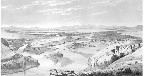
Original size, 18-1/4 by 9-3/4 in., A. E. Mathews, Pencil Sketches of Montana (1868).
The enlargement of the figure with labels extends from a sheep ranch at extreme right to a ferry across the Jefferson River at center, and a wagon road skirting the long, low elevation Lewis called a “handsom site for a fortification.” The artist, Alfred E. Mathews, described the setting:
The Three Forks of the Missouri is one of those rare and beautiful localities in nature, that, when once seen remains indelibly fixed in the memory. The Jefferson, Madison and Gallatin here mingle their waters, to form the Missouri River. These three tributaries of the mighty Missouri meander gracefully through an extensive valley, their banks fringed with picturesque groups of cottonwood and willow trees of various growths, with their sparkling waters occasionally seen through the dense foliage. Far in the distance the mountains near Virginia City are seen. The Jefferson comes in on the right, and its course is marked by a dense forest of cottonwood, nearly a mile in width. The course of the Madison is first indicated in the distance on the left, and joins the Jefferson about a mile from the point of observation; and here the Missouri commences.
In the middle distance on the left a few houses are seen, this is Gallatin City, the county seat of Gallatin county. This place is destined at no very distant period to be a large and flourishing town; it is most desirably located in the heart of a rich and extensive agricultural country, abounding in valleys of unrivaled richness, and uplands, plains, and mountains covered with nutritious grasses. Sixty three years ago Captains Lewis and Clark encamped here and explored the country. Not being able to detect much difference between the volume of water in the Jefferson and the Madison they discontinued the name of Missouri and gave to each river a separate name, which they bear to this time, and called the junction of three, The Three Forks.[1]A. E. Mathews (1831-1874), Pencil Sketches of Montana (New York: By the Author, 1868).
Sixty-three years. In those days, given a few good genes and a little luck, that was a full lifetime for the best of men and women anywhere, but especially in the remote reaches of the mountain West, where day-to-day survival demanded unfailing physical stamina and placed extreme demands on one or more of five fully functional faculties—chiefly eyesight and hearing—plus a sturdy frame and strong musculature.
Compared with the ensuing half-century, nothing of major import happened since the Corps of Discovery paused to rest their weary bodies in this broad, politically neutral meeting-place some Indians—Blackfeet, Lemhi Shoshones, Crows, Salish—called the “Valley of Flowers.”[2]E. Lina Houston, Early History of Gallatin County (Bozeman, Montana: By the Author, 1933), 7. We have no idea how many independent trappers or small groups actually passed among the Three Forks during the first 50 years after the expedition left it. The deaths of expedition veterans John Potts and George Drouillard at the hands of Blackfeet in 1810 did not disturb the placid valley, and were scarcely noticed even back in St. Louis, although John Colter‘s 200-mile dash for life from the Blackfeet, beginning on the Jefferson above the Three Forks and ending at Fort Raymond at the mouth of the Big Horn, quickly entered the jawbone journals of the Western fur trade. Famous trappers such as Jedediah Smith and William Sublette, and scout Kit Carson, saw the place in due time.
Gallatin City, 1863
In 1863 a settlement proudly and optimistically named Gallatin City[3]The first of three towns named after Albert Gallatin who was Secretary of the Treasury during the Lewis and Clark Expedition. sprang to life opposite the mouth of the Gallatin River under the hands of twenty-five pioneers, including James (eventually Probate Judge) Gallaher and Major J. B. Campbell, by authorization of the first Territorial legislature. All were inspired by the prospect that river commerce would be extended to the Three Forks valley as soon as a government-chartered shortline railroad was built around the Great Falls. They expected that their market area would include all the gold camps from Virginia City to the south and Helena to the north, as well as the Yellowstone Valley via Clark’s “high dry firm road” between the Big Bend and the head of the Gallatin River. Second thoughts dictated the moving of the first Gallatin City’s legal domain to a new location on the bank of the Madison River about two miles south, on the stage route. Hope survived in Gallatin City (No. 2) until the Northern Pacific Railroad laid its main line several miles to the south, and new options—the foundations of another phase of Western history—emerged. A third Gallatin City briefly came to mind, but no farther.
Fannie Campbell
Fannie Campbell was among the women who shared the excitement and the risks of settling in the valley of the Missouri’s headwaters. While her father began to put down his family’s roots there, Fannie finished her schooling at the conservatory in St. Charles, Missouri, before she and her older sister joined their parents at Montana Territory’s new Gallatin City in 1865. Nineteen-year-old Fannie’s voyage up the Missouri was interrupted by the wreck of the steamboat Bertrand about 25 miles north of Omaha, Nebraska. The girls escaped to the riverbank where they watched the Bertrand sink into the grasp of the Missouri’s muddy bottom. They waited a week for another boat, and when that one got stuck on a sand bar 200 miles downriver from Fort Benton a band of Indians attacked, wounding two men and capturing a third. Major Campbell and a friend rode hard from Gallatin City to rescue the girls and take them home. A year later, Fannie’s beloved piano arrived via steamboat to Fort Benton and wagon to her log home. One can only imagine the deep thrill the sound of that instrument drew from hearts still linked to distant homes, friends and families. Fannie’s piano-playing was a durable part of the valley’s soundscape for the rest of her life receding into silence only with her death in 1919 at the age of 73.
John Bozeman
The promises of discovery and renewal suffused the atmosphere of Lewis and Clark’s “essential point” even while the Civil War was rending the nation’s integrity. In 1863 a hardy, adventurous entrepreneur, John Bozeman, led a group of wagons from Fort Laramie on the trans-West Mormon Trail up to the gold fields at Virginia City. Disappointed by his own failure at prospecting in Colorado, he platted the town that would soon bear his name, and set out to “mine the miners.” In the course of things he would beat out those upstart Missourians and their little enterprise, 30 miles to the northwest. The two settlements briefly traded roles as the administrative center of Gallatin County, but Bozeman’s town eventually won out.
Bozeman’s own luck dried up suddenly in April of 1867, when he was murdered by unknown assailants near the Big Bend of the Yellowstone River. He was only 32. The general apprehension that Indians were guilty prompted the settlers to demand protection from the U.S. Army, with the result that Fort Ellis was quickly built—near the place on Kelly Creek where Clark and his detachment had camped on 15 July 1806, en route home.
The City’s Rise and Fall
The first flour mill was opened near Bozeman in 1864, and the first white woman to see the Three Forks arrived the following spring, but “Indian troubles” were still on the horizon, so after five weeks she and her husband, a farmer, moved back south to Bannack, then was the territorial capital. Within another two years the first church was built in the Gallatin Valley, and shortly thereafter the first church bell was brought to the valley, all the way from St. Louis. Think of the thrill that its tones, softly reverberating from the distant mountainsides, roused from the hearts of all hearers, believers or not, in the vast, sweet, overarching silence of the valley! In the ’70s came schools, a Masonic Lodge, and many other essentials of semi-urban American life.
Gallatin City grew somewhat and flourished, more or less, until 1883, when the Northern Pacific Railroad built its main line a few miles to the south—too far away for the ambitious community to benefit as a way station and trading center. By 1890 the old vision faded away, and the town was empty. In 1908 the electrified Milwaukee Railroad built a way station close by, and called it Three Forks. It was a transfer point for tourists heading toward Yellowstone National Park, which since 1876 had grown into a tourist attraction of worldwide appeal. It was only five miles southwest of Gallatin City, but that was still too far, and much too late anyhow. Those ambitious Missourians had long since roused from their delusions, and the settlement slowly dissolved into the earth. No trace of it remains today.
Alfred Mathews
Into this setting, in the mid-1860s, rode a solitary 35-year-old artist, Alfred E. Mathews, who had emigrated with his parents from his birthplace, Bristol, England, to Rochester, Ohio, at an early age. During service in the Union Army he was highly regarded as an illustrator of Civil War battles, among which his four lithographs of the siege of Vicksburg, and a panorama of the campaigns from Vicksburg to Savannah, were greatly admired. His postwar Western travels, at his own expense, through Nebraska, Colorado, Montana and California, led him a total of more than 6,000 miles. His sketches, not only rich in visual detail but also enhanced with penetrating observations, failed to compete profitably with copies of the colorful, supersized Western panoramas by Thomas Moran and Albert Bierstadt.[4]AskArt, http://www.askart.com/AskART/artists/biography.aspx?searchtype=BIO&artist=8738. Accessed 17 March 2006.
“The author,” wrote Mathews in the preface to Pencil Sketches of Montana, “has frequently been asked why he did not take a Photographic Instrument along, in order to photograph Mountain scenery; for it is generally supposed that a photograph of Mountain scenery is always perfectly accurate. This, however, is far from being the case.” His answer could have simply summoned the logistical issue: Cameras at that time were studio machines; there was no such thing as a hand-held instrument. However, his thoughtful reply was more original than that, and remains as true and instructive today as it was then.
In taking a picture, the lens of an instrument must be adjusted to focus on a certain object or objects; and all others more distant, or nearer, will be more or less indistinct. Another disadvantage of an instrument is that objects near at hand are magnified, while those farther off are reduced in size. So apparent is this defect in large photographs of persons that a small picture is now first taken, and afterwards copied and enlarged. Shadows, too, are apt to be deepened and lights intensified. A good artist can, with ordinary care, produce a more accurate and pleasing picture with the pencil or brush.
Mathews’ reputation still falls somewhat short of greatness in the regard of art historians. Nevertheless, his own self-published lithographs of Colorado and Montana have grown more and more valuable as documentaries of Western topography and history, as the decades have passed.
“Headwaters of the Missouri”
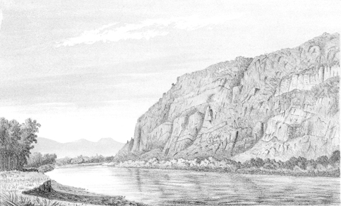
A. E. Mathews, Pencil Sketches of Montana (1868), Plate XXIII.
“. . . a view on the river immediately below the three Forks. The sketch of the Three forks [above] was made from the top of the high rocky bluff shown in this picture.”
As if he had anticipated the extent to which the romance of Western gold-mining would forever seize the imaginations of both writers and readers, Mathews reminded his own readers:
Miners were not the only class of men who endured hardships and toils almost beyond belief when Montana was first settled. Ranchmen or farmers had the same difficulties to contend with —high prices and scarcity of food and clothing.
Plows for breaking [sod] were worth from $125 to $150; common plows $80 each; hoes $8, picks $15, shovels $15, and axes $9 each in gold; other things in proportion.
For comparison, a private in the Union Army had started at $11 per month, up $6 from the scale the privates in the Corps of Discovery received. Clearly, once a prospective farmer had bought his land, he needed a sizeable stake just to start working it. Here in this booming land of opportunity, at least, the results were definitely worth the investment. “The Gallatin Valley,” observed Mathews, “is celebrated for its immense hay ranches; and horses and cattle are frequently driven down from the mining towns to winter at these ranches.”
Notes
| ↑1 | A. E. Mathews (1831-1874), Pencil Sketches of Montana (New York: By the Author, 1868). |
|---|---|
| ↑2 | E. Lina Houston, Early History of Gallatin County (Bozeman, Montana: By the Author, 1933), 7. |
| ↑3 | The first of three towns named after Albert Gallatin who was Secretary of the Treasury during the Lewis and Clark Expedition. |
| ↑4 | AskArt, http://www.askart.com/AskART/artists/biography.aspx?searchtype=BIO&artist=8738. Accessed 17 March 2006. |
Experience the Lewis and Clark Trail
The Lewis and Clark Trail Experience—our sister site at lewisandclark.travel—connects the world to people and places on the Lewis and Clark Trail.
![]()
Discover More
- The Lewis and Clark Expedition: Day by Day by Gary E. Moulton (University of Nebraska Press, 2018). The story in prose, 14 May 1804–23 September 1806.
- The Lewis and Clark Journals: An American Epic of Discovery (abridged) by Gary E. Moulton (University of Nebraska Press, 2003). Selected journal excerpts, 14 May 1804–23 September 1806.
- The Lewis and Clark Journals. by Gary E. Moulton (University of Nebraska Press, 1983–2001). The complete story in 13 volumes.
This site is provided as a public service by the
![]()
Lewis and Clark Trail Alliance
with additional funding from the following:

