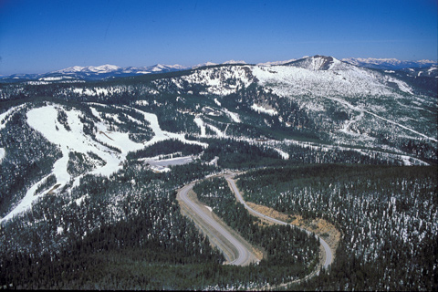
Clark’s journal for 3 September 1805 informs us that at the end of that day they “encamped on a Bran[c]h of the Creek [they] assended after crossing several steep points and one mountain.” We can’t say for sure that they were lost, and they didn’t admit to it in so many words, but Sergeant Gass’s laconic remark gives us a hint: “This was not the creek our guide wished to have come upon.” Fortunately, the topography provided Toby the perspective he needed—from the ridge that begins above the ski slopes in the photo—in order to determine the next day’s route.
But really, where did they camp? This was not the only time Toby was unsure of himself, nor that the captains were temporarily baffled, but it is perhaps the one that most readily invites study and discussion. In July 1997 the Salmon and Challis National Forests, and several other agencies and associations, sponsored a symposium of five amateur and professional historians and cartographers, each of whom described and illustrated his own theory as to the route the Corps might have followed, and the location of their camp on that night. The event was highlighted by an on-site exploration of each of the possibilities. In this instance, hindsight served merely to illuminate the scope of their uncertainty, but it dramatically underscored the adventure that the men faced almost daily on their journey through the wilderness.
The Corps had other matters on their minds. One was hunger. Clark’s journal continued: “but little to eate I killed 5 Pheasents [grouse] & The huntes 4 with a little Corn afforded us a kind of Supper.” Another was physical danger. They struggled over “emence hils and Some of the worst roade that ever horses passed.” Frequently the horses fell, and in one such instance, lamented Clark, “we met with a great misfortune, in having our last Thmometer broken by accident.” Worst of all was the weather. At dusk that day it began to snow, and misery continued to pile upon misery—”Snow about 2 inches deep when it began to rain which termonated in a Sleet.”
After all, though, the Corps of Discovery was fortunate to have made it over this ridge before winter set in. The snow depth at today’s Lost Trail Powder Mountain Ski Resort, shown on the left in the photo, can exceed fifteen feet.
After U.S. Highway 93, shown at the bottom center of the photo, was completed in the 1930s, the gap through which the highway crosses the Bitterroot Divide was named Lost Trail Pass at the urging of a local rancher who was well acquainted with the Lewis and Clark journals. The pass is not on the Continental Divide, but separates two major drainages of the Columbia River basin—the Salmon to the south, and the Bitterroot-Clark Fork to the north. However, the highway at right of center, which parallels U.S. 93 for less than a mile and joins it at the crest of the pass, surmounts the Continental Divide at about the point where it enters the picture at bottom center.
See also The Lost Trail Divide.
From Discovering Lewis & Clark from the Air
Photography by Jim Wark
Text by Joseph Mussulman
Reproduced by permission of Mountain Press