The Kansas River Joins the Missouri
View northeast down the Kansas and Missouri
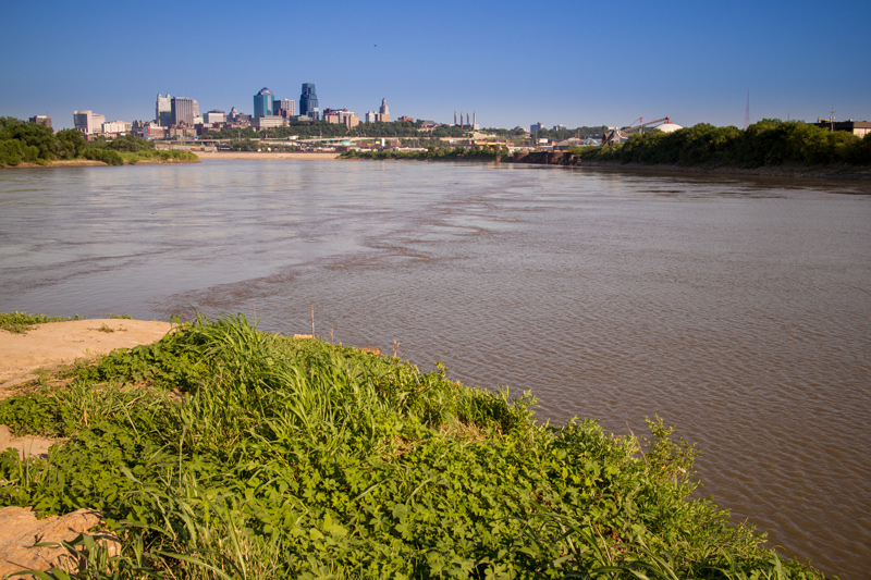
© 2015 by Kristopher K. Townsend. Permission to use granted under the Creative Commons Attribution-Share Alike 4.0 International license.
The Kansas River—at right, flowing northeast—is closer to its probable 1804 location than the Missouri, which then may have met it at nearly a right angle, approaching from somewhere this side of the petroleum depot at upper center. Private Whitehouse understood it was called “Decaugh”—perhaps his phonetic transliteration of the name by which local residents still know it, “The Kaw.” Today, the coordinates at the midpoint between the right and left banks of the Kansas where it touches the Missouri’s right bank are 39°06’54” North, 94°36′ 36″ West. On the north bank of the Missouri, at the right edge of the photo, the center of the confluence is at about 39°07′ North.
Kansas City, Kansas, is to the left of the rivers, plus a sliver at lower right; Kansas City, Missouri, is mostly out of the picture at upper right. Settlement on the Kansas side of the Missouri River began as a trading post built by François Chouteau in 1821, the year Missouri was admitted as the twenty-fourth state. It became a supply point for wagon trains heading west on the then-new Santa Fe Trail. It was the site of the first bridge anywhere on the Missouri River, built in 1869 to carry Northern Pacific rails westward.
Premature Plan
From Cincinnati, just thirty-four days after setting out down the Ohio from Pittsburgh, Lewis wrote to Jefferson he was concerned about the objections to his expedition some Congressmen had expressed, and declared, “I have concluded to make a tour this winter on horseback of some hundred miles through the most interesting portion of the country adjoining my winter establishment; perhaps it may be up the Canceze River and towards Santafee.”[1]Lewis to Jefferson, 3 October 1803. Jackson, ed., Letters, 1:131. It seems likely that both Lewis and Jefferson knew that ten years before, in 1792, the French explorer Pierre Vial, employed by authorities in new Spain, had blazed a trail between the mouth of the Kansas and Santa Fe.[2]Vial’s journal, edited by Alfred B. Thomas, is in “The First Santa Fe Expedition, 1792-1793,” Chronicles of Oklahoma, Vol. 9, No. 3 (June 1931), 195-208. It appears equally probable that Lewis hadn’t yet learned that the actual overland distance from St. Louis to the Kansas River was more than 250 miles. In any case, Jefferson fired back his response in straightforward terms:
One thing . . . we are decided in: that you must not undertake the winter excursion which you propose in yours of Oct. 3. Such an excursion will be more dangerous than the main expedition up the Missouri, & would, by an accident to you, hazard our main object, which, since the acquisition of Louisiana, interests every body in the highest degree. The object of your mission is single, the direct water communication from sea to sea formed by the bed of the Missouri & perhaps the Oregon. By having Mr. Clarke with you we consider the expedition double manned, & therefore the less liable to failure, for which reason neither of you should be exposed to risques by going off of your line.[3]Jefferson to Lewis, 6 November 1803. Jackson, Letters, 1:137.
So much for that notion. Evidently, however, Lewis’s remark did stick in Jefferson’s mind, for in his speech to a group of Osage Indian visitors the following July he outlined his plan for further explorations on the lower Missouri. With the same reasons as those behind the Lewis and Clark expedition, he had in mind “another party to go up the Red river to it’s source, thence to the source of the Arkansa, and down it to it’s mouth.”[4]That was the Freeman-Custis Expedition of 1806, which was aborted after Spanish forces turned it back 600 miles up the Red River of the South. Consistent with his strategy of leveling the geopolitical playing field by making Indians participants, rather than enemies, in the Americanization of Louisiana territory, he continued: “I also propose the next year to send another small party up the river of the Kansas to it’s source, thence to the head of the river of the Panis [the Platte], and down to it’s mouth; and others up the rivers on the North side of the Missouri. For guides along these rivers we must make arrangements with the nations inhabiting them.”[5]Jefferson to the Osages, 16 July 1804. Jackson, Letters, 1:201.
Up the River
From 26 June 1804 through 28 June 1804, the expedition’s campsite was somewhere to the left of the point where the rivers meet today. It was, according to Clark’s daily courses and estimated distances, 366 miles from the mouth of the Missouri—although it was probably closer to 390 miles then. Since about 1960, owing to the channelization, stabilization, and straightening of the Missouri for the benefit of river commerce, it has coincidentally been shortened to within a mile or two of Clark’s estimate.
Clark was informed by one of the engagés who had traded along the Kansas that the river took its name from the Indians known as the Kanzes, or Kaw, nation which at that time dwelt on its banks in “2 villages one about 20 Leagues [60 statute miles] & the other 40 Leagues [120 miles] up.” In their language the word kansas is said to mean “south wind,” which is the direction from which prevailing breezes blow during late spring and summer.
The captains’ informant must have regaled them with many tales about the land of the Kansas valley. “To Describe the most probable of the various accounts of this great river of the Kansas,” Clark demurred, “would be too lengthy & uncertain to insert here.”
Nevertheless, they decided to stay for several days to “recruit”—in those days the word meant rest—and at least get acquainted with this part of the river. The three days they spent here were marked with a procession of memorable events. First they hastily built a six-foot-high redoubt of logs and brush across the point, against the rumored possibility of an Indian attack, and in the process cleared a high point of trees to enable the captains to take celestial observations with the widest possible angles. (They had made a similar clearing for the same purpose back at the mouth of the Osage River on 1 June 1804.) They finally determined the latitude of the place to be 38°31’13” North—40 miles farther north than it actually is; they took notes on the contours of the flood plain and uplands; a nearby high point a mile up the west bank of the Kansas was “a butifull place for a fort, [with a] good landing place.” They measured the two rivers’ widths—the Kansas was 230-1/4 yards wide at its mouth, where the Missouri was 500 yards wide. They recorded the rivers’ flow in terms of daily rise and fall; took their respective temperatures; and even weighed their waters to measure silt. Clark could find only one fault with them: “The waters of the Kansas is verry disagreeably tasted to me.” On the last day of the hiatus, 29 June 1804, necessity dictated that they take time out to hold a court martial for Privates Collins and Hall. At 4:00 p.m. they set out up the Missouri again. Sgt. Floyd reported the captains seized the opportunity for “armes and amunition enspected all in Good order.”
Hunting was good hereabouts. They bagged quite a few deer not only for meat but also for clothing, and a number of the men were employed “Dressing Skins & making themselves Comfortable,” perhaps to make their GI woven clothing last longer. One of the hunters brought in a wolf pup to keep as a pet, but the little fella freed himself after three days, and went missing. Another hunter caught sight of the first buffalo any of them had encountered. (Ironically, the Kansas Indian villagers were reportedly “out in the plains hunting the Buffalow” at the time.) To top off the visit, they saw some flocks of now-extinct, colorful little Carolina parakeets in the neighborhood.
Notes
| ↑1 | Lewis to Jefferson, 3 October 1803. Jackson, ed., Letters, 1:131. |
|---|---|
| ↑2 | Vial’s journal, edited by Alfred B. Thomas, is in “The First Santa Fe Expedition, 1792-1793,” Chronicles of Oklahoma, Vol. 9, No. 3 (June 1931), 195-208. |
| ↑3 | Jefferson to Lewis, 6 November 1803. Jackson, Letters, 1:137. |
| ↑4 | That was the Freeman-Custis Expedition of 1806, which was aborted after Spanish forces turned it back 600 miles up the Red River of the South. |
| ↑5 | Jefferson to the Osages, 16 July 1804. Jackson, Letters, 1:201. |