When Wheeler was on the Columbia in 1902, he viewed the whitewater through which Lewis and Clark took their canoes and the place where the salmon were harvested in great quantities.
Cascade Locks
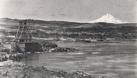
Fish Wheels on the Columbia in 1902
Photographer unknown, for Olin D. Wheeler, The Trail of Lewis and Clark. See also Wheeler’s “Trail of Lewis and Clark”.
This scene was photographed near the site of “Rock Fort,” the expedition’s campsite of 25–28 October 1805, and 15-18 April 1806. The structure at left houses a large fish wheel. Mount Hood, a stratovolcano 11,237 feet high, is approximately 45 miles away, southeast of Portland.
For thousands of years the Cascades of the Columbia, where the river twisted south then west while falling about sixty feet in three miles, had marked the western portal of the Columbia Gorge. They also served to define a division point in Indian river commerce. Wheeler emphasized the degree to which Progress had changed the picture:
Until recent years the Cascades blocked continuous navigation beyond them to The Dalles on the upper river, but after fifteen years or more of work and an expenditure of between three and four millions of dollars, the Government has now in operation a splendid lock at the Cascades, through which steamers pass with scarcely any loss of time.
Wheeler hoped that soon another set would take boats around The Dalles. “By so doing many miles of river now useless will be rendered available for navigation.” Thirty-five years after Wheeler’s 1902 visit, Bonneville Dam overcame nature’s obstruction to commerce. Only the uppermost part of the old lock system remains visible today, as a monument to the high-tech engineering of Wheeler’s era.
Celilo Falls
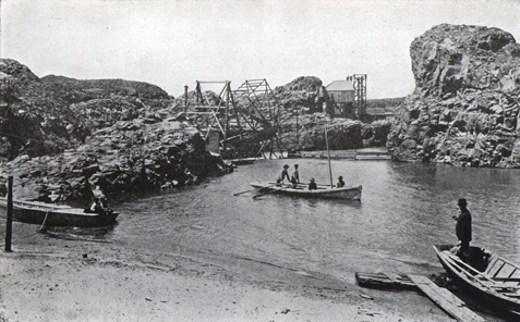
Photographer unknown, from Wheeler, The Trail of Lewis and Clark (1904), 2:93.
Now hidden beneath the surface of Lake Celilo behind The Dalles Dam, this maze of rocks in the “Long Narrows” was once a center of the Indian fishing industry, which in Wheeler’s day had been displaced by commercial fish wheels such as these.
At Celilo Falls—the captains’ “Great Falls of the Columbia”—on 23 October 1805, the Corps let canoes down by rope and portaged their cargoes overland. A scant century later, development along the bank was impressive:
Almost, if not quite, along the very ground over which Lewis and Clark dragged their canoes around [sic] the falls, the railway trains of the Oregon Railroad and Navigation Company now run, and travelers can, from the car windows, see at the distance of a stone’s throw this particular fall of twenty feet, and they have also a good view of this entire series of widespread and interesting cascades.
With notions of conservation and the intrinsic values of native fauna still decades in the future, Wheeler had no thought of what changes on the Columbia River might do to the salmon. Where the captains had described local Indians’ salmon catches and processing, Wheeler saw some stacks of Indians’ dried salmon, and remarked on the white man’s cannery at Celilo Falls.
Viewing such “improvements” as signs of progress, Wheeler included two photographs of fish wheels, the super-efficient rotating scoop that commercial fishermen had introduced on the Columbia in 1899. Within a few years seventy-six fish wheels were operating on the river, each capable of catching, on average, 6,000 fish (100,000 pounds) per year. Oregon banned the wheels in 1926, and Washington did so in 1934. During the next 40 years, beginning with the completion in 1938 of Bonneville Dam at the downstream end of the Cascades, the Columbia and the Snake were transformed into a series of sluggish reservoirs created behind dams. Even though some dams had fish ladders to help spawning salmon climb upstream, the dams would kill a majority of smolts (young salmon) heading downstream after hatching on Columbia tributary streams, leading to the necessity of relying on salmon hatcheries to replace the fish.
The Short and Long Narrows
Salmon Cannery on the Columbia River, 1902
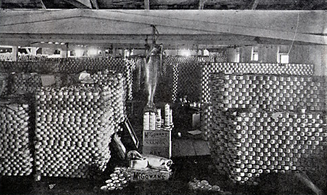
Photographer unknown, from Wheeler, The Trail of Lewis and Clark (1904), 2:168.
There are some 200,000 cans of salmon in this view. The first salmon cannery was built on the Sacramento River in California; two years later the first one was opened on the Columbia. By the early 1950s the seasonal salmon runs had been depleted, and the canning industry was at its end.
At The Dalles in 1902, a hospitable local citizen helped Wheeler make his way over the rocks of the riverbed “which, at high water, is a rushing torrent, to the brink of the long narrow channel and chasm through which Lewis and Clark took their canoes, where I overlooked the swirling waters as they boiled and raged.” Driving back to The Dalles, the pair witnessed a striking contrast between two cultures. At intervals, wrote Wheeler, they observed:
an Indian hut or two on the rocks or sands, a reminder of the ancient régime, while, as if to emphasize the great change which had overtaken the region aside from the unchangeableness of nature itself, a railway train with Pullman coaches filled with people came whirling along the track beneath us bound for Portland.
And then, as if to complete the picture appropriately, . . . out from the sombre rocks far over on the other side of the river, following one of the many narrow, thread-like channels, crept an Indian canoe bound for the town below.
Wheeler often took pains to learn the Indians’ names for major landmarks. He understood that the Indian name for Mount St. Helens–which explorer George Vancouver had named in 1792 in honor of the prominent British diplomat, Baron St. Helens–was “Lah-me-l·t-cla or -clough,” meaning “fire mountain.”[1]According to the U.S. Geological Survey, the Salish and Klickitat Indians called it Loo-wit lat-kla, or Louwala-clough, meaning “fire mountain” or “smoking mountain.” … Continue reading
In addition, he occasionally pleaded for the restoration of place-names Lewis and Clark had introduced. Seeing the 800-foot-high volcanic plug which had come to be called “Pillar” and “Castle” rock, Wheeler insisted that the name Lewis gave it should be restored. The U.S. Board on Geographic Names officially changed it back to Beacon Rock in 1916.
Locating Fort Clatsop
Another of Wheeler’s contributions to the historiography of the expedition was to publish the general location of Fort Clatsop. Wheeler visited the site with Portland attorney Silas B. Smith, the grandson of the Clatsop chief Coboway. When the Corps left their winter cantonment in the spring of 1806, they had given it to Chief Coboway, who showed Smith the site when the latter was a boy. Smith later became active in the Oregon Historical Society, and located the spot for that organization as well as for Wheeler, which led eventually to the establishment of the National Park Service’s Fort Clatsop National Memorial near Astoria, Oregon.
Notes