Cultural Divides
In the third week of October 1805, the Corps of Discovery reached a many-faceted barrier as they paddled downstream into the Columbia River Gorge. Just west past the Deschutes River, they faced Celilo Falls, which required a portage. The falls proved to be the beginning of fifty-some river miles that also held the Short and Long Narrows (jointly called The Dalles), and ended with the lengthy Cascades of the Columbia. As the Corps prepared for this part of their voyage, their Nez Perce escorts, the chiefs Twisted Hair and Tetoharsky, announced they were returning home because, from this point, they no longer could serve as diplomats and translators. Since the expedition had left the Rocky Mountains behind, these chiefs had voluntarily traveled with them, going ahead to introduce the white strangers to Columbia Plateau tribes who spoke languages related to theirs.
Celilo Falls
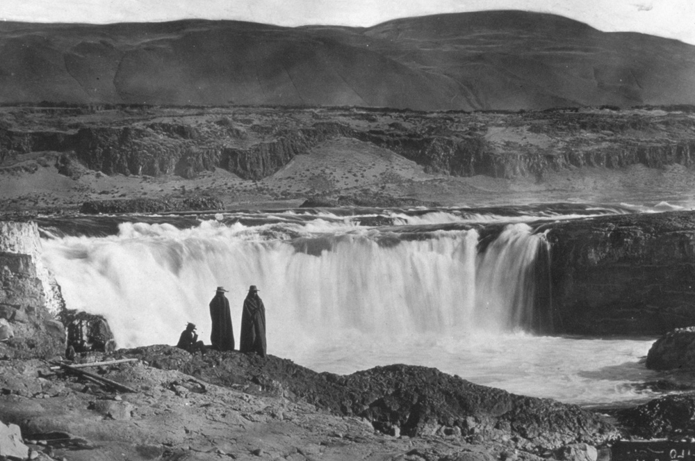
Photographer unknown.[1]The photographer above was likely Benjamin Gifford (1859-1936) who moved from the East to Portland in 1888, after a four-year sojourn in Kansas. He opened a large studio and photograph processing … Continue reading Courtesy U.S. National Archives and Records Administration, Record Group 18: Records of the Army Air Forces.
Celilo Falls was the first of the Columbia Gorge‘s series of cascades that challenged the Expedition.
The gorge’s physical barriers roughly demarcated the line between Sahaptin and Chinookan cultures and language families. As the captains understood the two Nez Perces, they were at war with tribes downstream, and urged the Corps to prepare to withstand attack from these nations. After the expedition successfully passed the string of waterfalls and rapids, it encountered a third facet to this major cultural divider: below the Cascades of the Columbia, they left the arid lands of the Columbia Plateau and entered into the constantly moist Pacific Northwest climate.
Moving quickly downstream in the autumn of 1805—even though slowed by the portages—the Corps passed through the region between the Deschutes River and the Cascades of the Columbia in thirteen days. Native reactions ranged from terror to insolence and threat, far different from the hearty welcomes recently received from the Lemhi Shoshones, Salish, and Nez Perces. Returning in the spring of 1806, when the Corps’ passage up this stretch of river lasted twenty-two days, they would learn more about what sharp traders[2]See The Wascos and Wishrams for information on women in this culture. they were among.
River Barriers
Detail from Clark’s 1814 Map[3]See Clark’s Maps.
To see labels, point to the map.
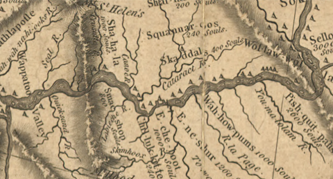
American Philosophical Society, Philadelphia.
The Columbia River Plateau was formed by a series of basalt flows occurring from seventeen to six million years ago. This silicon dioxide rock extrudes from volcanic vents in the ground, oozing to lower places until it hardens into rock with a grain so fine it cannot be seen by the human eye. The basalt flows covered 200,000 square miles—up to a half mile deep—in present Washington, Oregon, and Idaho. As the basalt cooled and crystallized, it developed “joint” or fault lines, along which the rock can fracture. One flow after another gradually redirected the Columbia River, pushing its mouth north from present Newport, Oregon. About two million years ago, the Cascade Range began to rise, uplifting as the Juan de Fuca tectonic plate pushed eastward and upward over the North American plate. East of these “old,” original mountains, the tectonic action caused a series of volcanic mountains to form the “new” Cascades, through which the Columbia flowed.
As the glaciers of the last Ice Age retreated, ice and melt water formed and re-formed the huge Glacial Lake Missoula of western Montana and Idaho. The Cordilleran Ice Sheet, extending south through British Columbia’s Purcell Trench, dammed the Clark Fork River (a Columbia tributary) at the present Montana-Idaho border. The ice dam towered to 2,000 feet above ground surface, impounding glacial melt water equal to modern Lake Erie and Lake Ontario combined. As many as forty times (ending about 13,000 years ago), this ice dam broke and vast torrents of water rushed westward with an estimated force of sixty times that of the Amazon River. Temporary lakes formed and drained along the Columbia’s path, as deep as 1,000 at The Dalles, and the flood widened the Columbia Gorge. Landslides of fracturing basalt reshaped portions of it.
Before 20th-century dams[4]Bonneville Dam, completed in 1937, raised the Columbia’s waters and hid the Cascades from sight, and The Dalles Dam (1957) covered the two Narrows and Celilo Falls. raised the river’s waters, basalt barriers to navigation existed at Celilo Falls, The Dalles (Short Narrows and Long Narrows), and the Cascades of the Columbia. When William Clark saw the river in its natural state in 1805, he estimated that, at the Short Narrows, the Columbia was constrained into a 45-yard-wide passage through black basalt, and at the Long Narrows it was from 50 to 100 yards wide. Upstream, he had measured the river’s width at 860 yards.
River Eco-system
The Columbia runs for 1,214 miles from Columbia Lake in British Columbia, with 754 of those miles in the United States. Over the latter distance, the river falls a total of 1,290 feet. In 1805, Clark estimated that the river fell 80 feet in the twelve miles that included Celilo Falls and The Dalles, and another 150 feet over the Cascades’ five-mile length.
As salmon swam up the Columbia in the days before dams, after they climbed the rapids at The Dalles, they paused to rest in eddies just upstream. Here they were easier to catch by net and spear, and native people gathered at the prime fishing areas, where families and villages had their own traditional spots. They harvested the fish mostly during spring and fall runs (ignoring the summer steelhead run), then sun-dried and pounded the meat into a pulp for storage and trading.
From the west end of the Columbia Gorge, the Cascade Mountains’ rain shadow extends east across the Columbia Plateau, limiting precipitation to a semi-arid 10″ annually—one-sixth that of the coastal zone. Hot, dry summers and warm autumns are followed by cool, somewhat rainy winters and springs. Before 20th-century irrigation systems, vegetation was sparse, and elk and deer moved from the mountains onto the plateau only during the winter. Columbia River salmon, preserved for long storage by drying, became the year-round staff of life for native peoples.
Great Trading Mart
Beginning about 10,000 years ago, people lived along this nurturing river. The area where the Columbia formed a natural travel barrier—from the Cascades to Celilo Falls—developed into a cultural and language barrier between Chinookan peoples toward the Pacific and the Sahaptin peoples inland.
The barrier also became a meeting and trading place for the native peoples. At The Dalles a great mart developed, where goods from the coastal trade network were exchanged for those that had come from as far east as the Northern Plains buffalo country. Enemies could trade together under temporary truce, so that the feared Paiutes from the south could trade Shasta slaves, captured in northern California, for pounded salmon and wapato roots. Eventually the spoken Chinook Trade Jargon developed, a lingua franca that served this area as Plains Indian Sign did east of the Rockies.[5]It is well known that Chinook Trade Jargon existed by the time of the Corps of Discovery’s visit. The easy-to-learn language mixed Chinookan, Sahaptian, French, English, and Hawaiian words in a … Continue reading Through this trading channel, only decades before the Corps arrived, horses had begun passing from the Nez Perces, Flatheads, Shoshones, and Cayuses to the Plateau peoples.
When Lewis and Clark reached the Shoshones just west of the Rockies in modern Idaho, they had received at least an inkling of the trade path that stretched from the Pacific, because Chief Cameahwait—whose people never traveled to the ocean—greeted red-haired Clark by tying pieces of seashell into the captain’s locks. From the Nez Perce on 21 September 1805, Clark erroneously understood through a long translation chain that beads and brass items came to them from whites living on the Columbia River: “the river passed thro’gh the mountains at which place was a great fall of the water passing through the rocks, at those falls white people lived from whome they preceured the white Beeds & Brass &c. which the womin wore.” But whites were not yet present on the Columbia above its mouth, where European sailors had been trading for furs since the early 1790s. These goods had come up the river in native hands. Although the Nez Perces had a few brass kettles and iron arm bands, at the John Day River the Corps began seeing more plentiful European trade goods and sailors’ clothing in Indian villages.
The extent of this trading network’s eastern arm became apparent in spring 1806 when the expedition returned to Nez Perce country. They recognized an iron battle ax that had been crafted by blacksmiths John Shields and Alexander Willard for the Hidatsas in the winter of 1804-1805, which had within the year been traded across the Rockies. Via this general route, items made of bison products were traded to The Dalles, and eventually even the Plains Indian tipi design traveled to the Columbia—where local Indians substituted woven mats for Plains-style leather covers.


Celilo Falls Portage is a High Potential Historic Site along the Lewis and Clark National Historic Trail managed by the U.S. National Park Service. On-site access is restricted, but nearby Celilo Park provides public viewing and interpretation of the area from the Oregon side of the river.—ed.
Notes
| ↑1 | The photographer above was likely Benjamin Gifford (1859-1936) who moved from the East to Portland in 1888, after a four-year sojourn in Kansas. He opened a large studio and photograph processing plant in The Dalles in 1899, which he ran until selling it to his assistant and returning to Portland in 1910, a decade before his retirement. While in business at The Dalles, Gifford shot scenic views of the area like this one, which was probably on a glass plate negative. |
|---|---|
| ↑2 | See The Wascos and Wishrams for information on women in this culture. |
| ↑3 | See Clark’s Maps. |
| ↑4 | Bonneville Dam, completed in 1937, raised the Columbia’s waters and hid the Cascades from sight, and The Dalles Dam (1957) covered the two Narrows and Celilo Falls. |
| ↑5 | It is well known that Chinook Trade Jargon existed by the time of the Corps of Discovery’s visit. The easy-to-learn language mixed Chinookan, Sahaptian, French, English, and Hawaiian words in a simplified syntax. (The Hawaiian contribution came from Hudson’s Bay Company employees enlisted in the Sandwich Islands and brought to Fort Vancouver—comprising up to 40% of the fort’s employees in the 1840s.) |
Experience the Lewis and Clark Trail
The Lewis and Clark Trail Experience—our sister site at lewisandclark.travel—connects the world to people and places on the Lewis and Clark Trail.
![]()
This page was funded in part by a grant from the National Park Service's Challenge Cost Share Program.
Discover More
- The Lewis and Clark Expedition: Day by Day by Gary E. Moulton (University of Nebraska Press, 2018). The story in prose, 14 May 1804–23 September 1806.
- The Lewis and Clark Journals: An American Epic of Discovery (abridged) by Gary E. Moulton (University of Nebraska Press, 2003). Selected journal excerpts, 14 May 1804–23 September 1806.
- The Lewis and Clark Journals. by Gary E. Moulton (University of Nebraska Press, 1983–2001). The complete story in 13 volumes.
This site is provided as a public service by the
![]()
Lewis and Clark Trail Alliance
with additional funding from the following:

