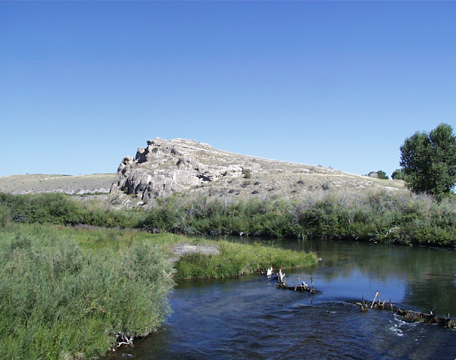
Surveyor’s Station
Clark’s Lookout on the Beaverhead River
View northwest
© 2001 VIAs Inc.
Impelled by the urgency of finding the Shoshones and making their way down the Columbia to the Coast before winter set in, Lewis and three companions proceeded ahead overland on 8 August 1805, leaving Clark in command of the main contingent in the canoes. Five days later, Lewis succeeded in making contact with Cameahwait’s band of Shoshones on the Lemhi River, and began learning the bad news about river travel on that part of the upper Columbia. He was told that was out of the question.
That same day, 13 August 1805, Clark arrived at this “high Point of Limestone rocks” and strolled to its low summit, perhaps carrying his circumferentor, or surveyor’s compass.
The highest point on the outcrop is 5102 feet above sea level, but only 40 feet above the flood plain here. Owing to the curvature of the Earth, the farthest a 6-foot-tall person can see on perfectly flat land is only about 3¼ miles; from 40 feet higher he can, ideally at least, see about 9 miles, and farther if there hills or mountains with tops that rise above the horizon. This, then, was a convenient place from which to take at least three different bearings, making of it a surveyor’s “station” or triangulation point. “From the top of this rock,” he wrote:
Point of the Beaver head hill bears N. 24° E 12 ms.
The Course of the Wisdom river is— N. 25° W.
The gap at the place the river passes thro’ a mountain in advance is— S. 18° W. 10 ms.”
Canoeing up the Beaverhead
The Beaverhead River, Clark explained, “obliges the men to undergo great fatigue and labour in hauling the Canoes over the Sholes in the Cold water naked.” For example, the riffles at right foreground, beginning where small driftwood has collected on the upstream edge, signify a short shoaly stretch of water no more than a few inches deep. Shoals like this were encountered with increasing frequency as they ascended the Jefferson/Beaverhead River. In fact, ever since their departure from Fort Mandan on 7 April 1805 most of the men had been wearing only deerskin loin cloths while on the river, owing to the continual necessity of wading to cordelle their canoes or wrestle them over shallows such as this. Equally as exhausting as the physical labor was the temperature of the water, which hereabouts may have been close to 50° Fahrenheit at that time of year in 1805. Undoubtedly they were hypothermic much of the time.
Another factor was the snail’s pace of their forward progress, which slowed all the more as the river grew narrower. The straight-line distance from Clark’s lookout to that promising gap in the mountains (at Rattlesnake Cliffs), is only 13 miles, but the distance by water is 24 miles. No wonder, as Clark wrote in his journal for the previous day, 12 August 1805, the “men complain verry much of the emence labour they are obliged to undergo & wish much to leave the river.” Discreetly, with what must have sounded like a feeble gesture that none of them could really buy, he added, “I passify them.”
Clark’s party camped near the lookout rock that night, but had “no wood except dry willows and them Small”—like the shrubby growth on the far shore. The small trees at right would have been a welcome sight, but those were planted much later by farmers. Clark met up with Lewis and his small party on 17 August 1805, and together they set up Fortunate Camp.


Clark’s Lookout is a High Potential Historic Site along the Lewis and Clark National Historic Trail managed by the U.S. National Park Service. The site is a Montana State Park near Dillon.—ed.
Experience the Lewis and Clark Trail
The Lewis and Clark Trail Experience—our sister site at lewisandclark.travel—connects the world to people and places on the Lewis and Clark Trail.
![]()
This page was funded in part by a grant from the National Park Service's Challenge Cost Share Program.
Discover More
- The Lewis and Clark Expedition: Day by Day by Gary E. Moulton (University of Nebraska Press, 2018). The story in prose, 14 May 1804–23 September 1806.
- The Lewis and Clark Journals: An American Epic of Discovery (abridged) by Gary E. Moulton (University of Nebraska Press, 2003). Selected journal excerpts, 14 May 1804–23 September 1806.
- The Lewis and Clark Journals. by Gary E. Moulton (University of Nebraska Press, 1983–2001). The complete story in 13 volumes.
This site is provided as a public service by the
![]()
Lewis and Clark Trail Alliance
with additional funding from the following:

