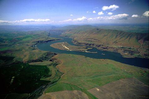
Miller Island
Sergeant John Ordway recorded that on the morning of 22 October 1805, the canoes passed “a high Island which had towers of Solid rocks and verry high and rough.” Warned, perhaps by Pierre Cruzatte or Labiche, that there was a bad rapid on the north side, they went by near the south bank. That was a fortunate circumstance, for otherwise they might not have seen that “a large river puts in verry rapidly [south] of the Island about 40 yards wide”; it had “Several perpinticular falls near its mouth.” The island the sergeant referred to is the one at the center of the photo above, known since the mid-19th century as Miller Island. The “large river” that enters the Columbia from the south, passing under the two short, thin white lines that are bridges, is the Deschutes, which Lewis and Clark learned to call Towarnehiooks, and later Clark’s. The city of The Dalles is faintly visible at left of the Columbia’s turn toward the south, in the far distance. Near the party’s campsite of 22 October 1805, was Nixluidix (Wishram) and the famous petroglyph of Tsagiglalal.
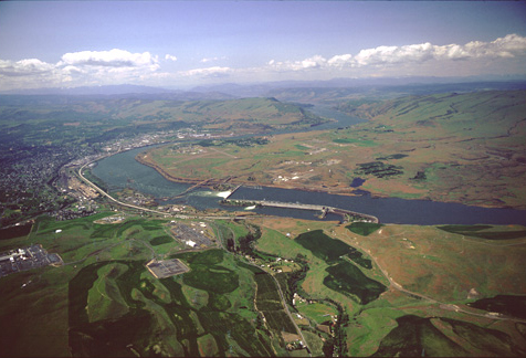
The Dalles Dam
The Dalles Dam, in the foreground, was built between 1952 and 1960. It impounds a 24-mile-long slackwater pool called Lake Celilo, which covers the sites of the Celilo Falls as well as the Short and Long Narrows. Its navigation lock is capable of lifting river traffic as much as 90 feet above the level of Lake Bonneville.
View west
To see labels, point to the image.
© 2001 Airphoto, Jim Wark. All rights reserved.
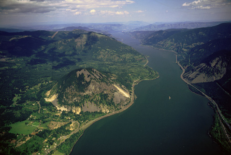
Quiet Reach
Between the Great (Celilo) Falls and the head of what Clark called the “Great Shoot” was a 40-mile stretch of river littered–during the low-water season–with “large ruged rocks,” the detritus of a landslide that some 7,000 years ago blocked the water’s path through the Cascade Range toward the Pacific. Seen from an altitude of approximately 1,200 feet in the early-morning hours, the modernized Columbia River is as placid as it looks, although by 10:00 a.m., as the hot-air thermals from the Columbia Plateau begin to draw cool marine air through the Gorge, a mighty wind still cranks upriver against the current at anywhere from 20 to 30 mph, raising waves four to six feet high, and even higher on “Nuclear” wind days. That was the power the expedition succumbed to on several days in April 1806, a force surely as maddening as the inescapable plagues of fleas and body-lice. “The river rose 8 Inches to day from what cause I cannot Say certainly,” he wrote on 26 October 1805, “as the tides cannot effect the river here as there is a falls below. I conjecture that the rise is owing to the winds which has Set up the river for 24 hours past.” He was probably correct, although the condition would have been exceptional for that time of year, since the normal daily winds are easterly from September through early April.
Now the fleas and lice are gone, but those same spring-summer winds now make the city of Hood River–which is roughly halfway between the now-submerged Dalles and the smoothed-over Cascades of the Columbia–the “wind surfing capital of the world.” No longer are rugged rocks the dreaded obstacles they once were. Today it’s the risk of being swamped by towering waves, or drowned beneath a string of barges, which make the wise wind-surfer or para-surfer cautious.
Hood River is situated at the mouth of the southern tributary of the same name, which Lewis and Clark called “River Labiche,” for Private François Labiche, the half French, half Omaha Indian, whom the captains regarded highly as a riverman, hunter and, especially, interpreter.
View east
To see labels, point to the image.
© 2001 Airphoto, Jim Wark. All rights reserved.
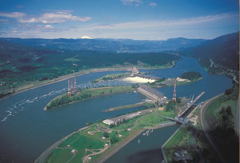
Bonneville Dam
Bonneville Dam, begun in 1933 and completed ten years later, was the first dam to be built on the Columbia River. The slackwater pool it impounds, called Lake Bonneville, eliminated the Cascades as a barrier to commercial shipping, and provided a deep, navigable channel for barges and tugs throughout its 48-mile length. The lift-lock, near the southeast riverbank (at right), raises vessels as much as 60 feet. The river is considered to be at tidewater level, although as Clark observed, it was then measurable only when the river was at its lowest. Tides are scarcely perceptible in any season now. The snow-capped peak on the horizon is Mount Adams.
Benjamin Louis Eulalie de Bonneville (1796-1878) was a French-born officer in the U.S. Army, who is best remembered for his expeditions to the Oregon Country, including the pioneering of parts of the Oregon Trail. Washington Irving’s story of the famous fur-trapper and explorer, The Adventures of Captain Bonneville (1850), is a classic in American literature.
View northeast
© 2000 Airphoto, Jim Wark. All rights reserved.