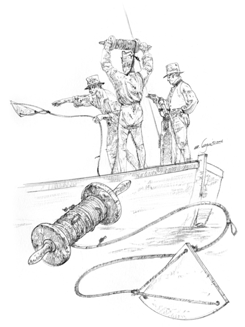
River Speedometer
© Michael Haynes, https://www.mhaynesart.com. Used by permission.
Among the various “Mathematical Instruments” Lewis purchased in 1803 from Thomas Whitney, of Philadelphia—a sextant, a two-pole surveyor’s chain, a brass boat compass, and so on—was a “log line reel & log ship.”[1]Jackson, ed., Letters, 1:82; Whitney is introduced on 1:53. This device was typically used for measuring the speed of a vessel at sea, but it could also be used to measure the velocity of a river’s current. It consisted of four parts: a log-ship, or log-chip; a specially calibrated log-line; a reel to hold the log-line; and a log-glass, or sand-glass.
The log-ship usually was a flat piece of wood in the shape of a quarter of a circle, which was weighted with lead on its arc to make it float vertically in the water, with the point up.
Log-line
Two short lines were passed through holes at each corner of the arc and knotted to hold them secure. A third cord was tied to a bone peg that was inserted in a hole at the point, from which it could be jerked free to facilitate retrieval of the ship. The three short lines were spliced together and attached to one end of a stray line, which was in turn spliced to the end of the log-line. The stray-line was long enough—perhaps 10 fathoms (60 feet)—to ensure that the log-ship could be hove far enough away from the boat as to be outside the effects of the anchored boat’s wake. The splice of the stray-line with the log-line was marked with a small red flag to indicate where the measurement of speed was to begin.
The log-line was divided into equal lengths with knots of twine interwoven with its strands. The distance between those points was called a knot. Clark indicates the expedition’s log-line was calibrated in fathoms.[2]Owens, s.v. “Log.” The number of knots that were unwound from the reel in 30 seconds gave the speed in “knots,” or could be converted to miles-per-hour. Or, the number of seconds it took to reel out 50 fathoms of log-line could easily be converted into miles-per-hour.
Log-reel
The simple log-reel routinely used to store a log-line seems highly inefficient today—imagine reeling in 600 feet of line without the advantage of a cranking mechanism. The log-glass was a timer in the shape of a miniature hour-glass half filled with fine sand, powdered eggshells, or marble dust, which would flow by gravity from the top half to the bottom through the intervening hole in precisely 30 seconds.[3]According to Owen’s Dictionary, the sailor’s log-glass was typically a 30-second measure. No such item is found in the expedition’s list of supplies and equipment, although perhaps it was such an obvious necessity to a river navigator that it was no more worth writing down than, say, the straight razor every soldier had to carry.
The first mention of the use of the log-ship during the expedition appeared on 17 June 1804, when Clark observed: “The Current of the River at this place is a Stick will float 48 poles 6 feet in the rapidest part in 23 Seconds, further out is 34, Still further 65–74–78 & 82 are the Trials we have made.” A month later (17 July 1804), he noted: “The Common Current taken with a Log runs 50 fathen [fathoms] in 40″—Some places much Swifter in 30″ and even 20 Seconds of time.”[4]The party was in the vicinity of “Bald Pated Prarie,” roughly 580 miles up the Missouri River. A rate of fifty fathoms in 40 seconds would equal 7.5 feet per second, or 5.11 miles per hour; 300 feet in 30 seconds would be 10 feet per second, or 6.82 miles per hour; 300 feet in 20 seconds would equal 15 fps, or 10.23 mph. On the eighteenth, some 7½ miles farther up the Missouri, Clark reported that the “Current runs 50 fathm. in 41 Seconds,” which equals 7.32 fps, or 4.99 mph.[5]Whereas speeds on the high seas were expressed simply in knots (not “knots-per-hour”) or in nautical miles of 6080 feet, river speeds were cited in statute miles of 5280 feet. At such … Continue reading That last example suggests the person responsible for timing might have used the more accurate chronometer rather than a sand-glass. The differences in velocities would reflect the varying gradients of the thalweg, or deepest part of the river channel.
How Fast?
Another Example . . .
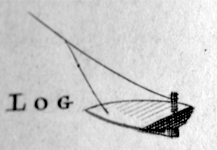
Courtesy Special Collections, Watzek Library
. . . of a log ship, or chip. This one, illustrated in Owen’s Dictionary, was described as “a flat piece of wood, shaped somewhat like a flounder, with a piece of lead fastened to its bottom, which makes it stand or swim upright in the water.”[6]Details of the construction of a log-ship and log-line varied according to the ingenuity of the craftsman and the circumstances of its specific use. For example, the article in the four-volume … Continue reading
Why were Lewis and Clark interested in the speed of a river’s current? Basically, because this was a subtle but crucial measure of the geography of the West, a dimension of the “face of the land” that they were directed to describe. In a more practical sense, however, it was important because at that time boats were the best means of hauling the most cargo at the least cost, so the major rivers that laced the land together were natural arteries for commerce, exploration, and other purposes. The average velocity of a previously unfamiliar river was a key to estimating the amount of time and labor that would be required in ascending it. For example, at Camp Dubois in January 1804, William Clark applied his experience on the Ohio, the Mississippi, and the Wabash rivers to calculate how long the round trip would take from St. Louis to the Pacific Ocean and back, at an average rate of either ten or twelve miles per day going up the Missouri.[7]Moulton, Journals, 2:159-60. Actually, in the first 600 miles to the mouth of the Platte River, they averaged roughly 11.5 miles per travel day. If their work-days averaged 10 hours, that meant they had to exceed the average speed of the current by approximately 1.15 miles per hour to cover 11.5 miles per day. Of course, any number of unforeseen factors could affect their progress one way or the other.
“Summary View of Rivers and Creeks”
At Fort Mandan during the winter of 1804–05, Lewis wrote a highly detailed “Summary View of Rivers and Creeks” which included a list of the measurements they had taken of the Missouri’s rate of flow:
From the experiments and observations we are enabled to make, with rispect to the comparitive velocity of the currents of the Mississippi, Missouri and Platte rivers, it results, that a vessel will float in the Mississippi below the mouth of the Missouri, at the rate of four mils an hour; in the Missouri from it’s junction with the Mississippi to the entrance of Osage river at the rate Of 5½ to 6 miles an hour; from thence to the Kanzas, from 6½ to 7; from thence to the Platte, from 5½ to 6 miles an hour, while that of the Platte is at least 8. The current of the Missouri above the entrance of the Platte is equal to about 3½ miles an hour as far as the mouth of the Chyenne river, when it abates to about 3 miles an hour, with which it continues as far as we have yet ascended it, and if we can rely on the information of the Indians, it’s current continues about the same to the falls of the Missouri, situated five hundred miles above Fort Mandan.[8]Moulton, Journals, Fort Mandan Miscellany, “Summary View of Rivers and Creeks,” 3:348. An incomplete draft of this summary, dated 21 July 1804, was found in the Field Notes.
Here, for the sake of clarity, is a tabulation of Lewis’s narrative, with point-to-point mileages added:
| River Stretch | Average Speed | Distance[9]From Clark’s list of estimated distances. Moulton, Journals, 8:377-382. |
|---|---|---|
| Mississippi below mouth of Missouri | 4 mph | 0 |
| Mississippi to the Osage | 5½ to 6 mph | 256 |
| Osage to Kansas | 6½ to 7 mph | 84 |
| Kansas to Platte | 5½ to 6 mph | 260 |
| Platte River | 8 mph | – |
| Platte to Cheyenne | 3½ mph | 710 |
| Cheyenne to Fort Mandan | 3 mph | 230 |
| Fort Mandan to Falls of Missouri | 3 mph (estimated) | 1035 |
Although determining the speed of a river with a log-line, reel and ship was methodical, river currents are more or less chaotic, and the mathematical results had to be rounded out with the practiced eye of a competent riverman like Pierre Cruzatte, Labiche, or Clark.
Apparently no effort was made to determine the velocities of the rivers they traveled west of the Rockies—the Clearwater, Snake, and Columbia—either going or returning.
Notes
| ↑1 | Jackson, ed., Letters, 1:82; Whitney is introduced on 1:53. |
|---|---|
| ↑2 | Owens, s.v. “Log.” |
| ↑3 | According to Owen’s Dictionary, the sailor’s log-glass was typically a 30-second measure. |
| ↑4 | The party was in the vicinity of “Bald Pated Prarie,” roughly 580 miles up the Missouri River. |
| ↑5 | Whereas speeds on the high seas were expressed simply in knots (not “knots-per-hour”) or in nautical miles of 6080 feet, river speeds were cited in statute miles of 5280 feet. At such slow speeds the distinctions are relatively insignificant. |
| ↑6 | Details of the construction of a log-ship and log-line varied according to the ingenuity of the craftsman and the circumstances of its specific use. For example, the article in the four-volume encyclopedia the captains had with them, familiarly known as Owen’s Dictionary, indicated that the log-line would be marked off not in fathoms but in fifty-foot knots.A New and Complete Dictionary of Arts and Sciences; comprehending all the branches of useful knowledge. . . . Illustrated with above three hundred copper-plates, curiously engraved by Mr. Jeffreys, geographer and engraver to his Royal Highness the prince of Wales. The whole extracted from the best authors in all languages, by a Society of Gentlemen. London: Printed for W. Owen. 1764. |
| ↑7 | Moulton, Journals, 2:159-60. |
| ↑8 | Moulton, Journals, Fort Mandan Miscellany, “Summary View of Rivers and Creeks,” 3:348. An incomplete draft of this summary, dated 21 July 1804, was found in the Field Notes. |
| ↑9 | From Clark’s list of estimated distances. Moulton, Journals, 8:377-382. |