Nature’s silence is its one remark,
and every flake of world is a chip off
that old mute and immutable block
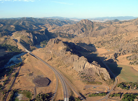
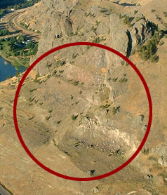
Leaving Canoe Camp
Figure 1
“this rock I called the tower”
—Meriwether Lewis
To see labels, point to the image.
© 2003 Robert G. Rumney.
Bob Rumney, a rancher who lives southeast of the town of Cascade, Montana, eight miles down the Missouri (behind the photographer), shot this view of Tower Rock from his powered parachute. The view is generally south-southwest; the rock’s azimuth is about 210° or, in Lewis and Clark’s terms, S30°W. Visible beyond the Adel Mountains, 21 miles upriver, is the valley in which “Ordway’s Creek,” now Little Prickly Pear Creek, enters the Missouri. The settlement called Hardy, out of the picture at lower left, was a way station on the Great Northern Railroad from 1888 until 1915. There was even a school there for a few years, with some of the students having to boat across the river to attend.
Lewis walked into Clark’s “canoe camp” at about 9:00 a.m. on 13 July 1805, having “bid a cheerfull adue” to the upper portage camp at White Bear Islands (see The Portage.). Clark’s four axmen were busy completing two new 3-foot-wide cottonwood dugouts—one 33 feet long, the other only 25—to take the place of Lewis’s “experimental” iron-framed, skin-covered canoe that had been abandoned as a failure. That was the day when he mused, “we eat an emensity of meat; it requires 4 deer, an Elk and a deer, or one buffaloe, to supply us plentifully 24 hours.” More of a reflection than a statistic, it hid his gloomy angst over the probability that, as the Indians at Fort Mandan had predicted, game would be scarce once they entered the Rocky Mountains.
Meanwhile the six old canoes, carrying two men each under the command of Sergeant Ordway, brought the company’s baggage from White Bear Islands up to Clark’s camp, arriving at noon on the 14th. That morning, Lewis climbed a bluff northwest of the river, near the mouth of “Fort Mountain Creek,” and took compass bearings on the three chains of the Rocky Mountains he believed he could see from there. (see Mapping the Rockies)
After breakfast on the fifteenth they all set out upriver, with Clark in command of the eight heavily loaded vessels while Lewis proceeded again on foot, this time with privates John Potts and Jean-Baptiste Lepage, who were too sick to help with the canoes. The next day he hurried on ahead to “the point where the river enters the Rocky Mountains,” in order to make the celestial observations needed to establish the latitude and longitude of that clearly “remarkeable” point, as President Jefferson had required of him. He was motivated also by evidence that Indians, perhaps Shoshones, had recently been in the vicinity, which he took as a sign they could expect to meet Sacagawea‘s people at any moment. It was perhaps for that reason that he took along his principal interpreter, the sign-talker George Drouillard.
Initial Observations
Figure 2
Sharp Curve
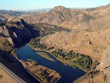
© 2003 Robert G. Rumney.
Bob Rumney’s view from his powered parachute looking south, upriver, shows the upper terminus of the portage route around Tower Rock, and the narrow south margin where “the Missouri washes it’s base.” Exactly one year later, on their return trip from Fortunate Camp back to the Great Falls of the Missouri, Sergeant Ordway and his detail of 9 men in six canoes stopped here for lunch. Because a brisk headwind made the safe descent of Pine Island Rapid unlikely, they stayed until it abated later in the day.
Owing to the deeper channel and the increased velocity of the current in the tight bend at the rock’s foot, the upstream terminus of the portage, where the dugouts were beached, probably would have been somewhere in the vicinity of the large island.
About noon they stopped four miles short of their destination for an hour or two and observed the Meridian Altitude of the sun’s “lower limb” with the octant by the “back observation.” He recorded it as “Point of observation No. 30,” which is shown much too far downstream on Clark’s map (Figure 4). The latitude Lewis obtained was 46°46’50.2″. Had he used the correct index error it would have read 47°14’52”, which would have been only about one-third of a mile north of the the actual location—probably 47°14’03”.[1]One degree of latitude at 47° north equals 69.08 statute miles; an arc minute (1/60th of a degree) equals 1.15 miles; an arc second equals 101.2 feet.
After that, Lewis recounted,
we pursued our rout through a high roling plain to a rappid immediately at the foot of the mountain where the Missouri first enters [properly, “exits”] them. the current of the missouri below these rappids is strong for several miles, tho’ just above there is scarcely any current, the river very narrow and deep abo[u]t 70 yds. wide only and seems to be closely hemmed in by the mountains on both sides, the bottoms only a few yards in width. an Indian road enters the mountain at the same place with the river on the Stard side and continues along it’s border under the steep clifts. these mountains appear to be only about 800 feet above the river and are formed almost entirely of a hard black grannite.
Lewis continued:
at this place there is a large rock of 400 feet high wich stands immediately in the gap which the missouri makes on it’s passage from the mountains; it is insulated from the neighbouring mountains by a handsome little plain which surrounds it on 3 sides and the Missouri washes it’s base on the other, leaving it on the Lard. as it decends. this rock I called the tower. it may be ascended with some difficulty nearly to it’s summit, and from it there is a most pleasing view of the country we are now about to leave. from it I saw this evening immence herds of buffaloe in the plains below.
By the end of the day he had to confront a more mundane and personal issue. The mosquitos had grown “extreemly troublesome.” Moreover, perhaps still wracked with disappointment over the recent failure of his experimental iron-framed boat, and distracted by the excitement of reaching the “first chain” of the Rockies, he had forgotten to bring his “bier.” He was utterly exasperated. “I . . . promised in my wrath that I never will be guil[t]y of a similar peice of negligence while on this voyage.”
Canoeing up the Rapids
Figure 3
Looking Back
To see labels, point to the image.
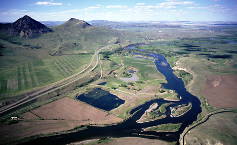
© 2001 Airphoto, Jim Wark. All rights reserved.
Taken from above a point approximately two miles northeast of Tower Rock, this view looks back upon the buffalo country the Corps of Discovery had traversed since leaving White Bear Islands. The four topographic features identified are on the fringe of the Adel Mountain Volcanics. From the explorers’ perspective as they passed by it, the lacolith they dubbed “Fort Mountain” [Square Butte] was the most conspicuous.
Despite the nocturnal distress those vicious little Aedes had inflicted upon him, Lewis was back on task early the next morning. “There is a large pine tree situated on a small island at the head of these rappids above our cam[p]; it being the first we have seen for a long distance near the river I called the island pine island.”[2]Editor Nicholas Biddle mentioned Pine Island in his 1814 paraphrase of the captains’ journals, but did not repeat their name for the rapid, so until after Thwaites’s publication of the … Continue reading
At 8:00 a.m. on the seventeenth, Clark and the canoes arrived at Lewis’s camp. After breakfast Lewis, concerned about the potential dangers of bucking the rapid, and the safety of his precious navigational tools, declared, “I had the box which contained my instruments taken by land arround tower rock to the river above the rappid; the canoes ascended with some difficulty but without loss or injury, with their loads.” Sergeant Ordway, who was in command of the flotilla, added a few more details to the scene:
we left Some articles and doubled maned the canoes and them all over Safe which was about half a mile long, & roled white over the rocks, but by the assistance of the towing lines we got up all the canoes without Injury Sent back for the other articles.
The six canoes that left the camp at White Bear Islands on 12 July 1805 were each manned by only two soldiers, partly because the boats were so heavily loaded with baggage and supplies. No doubt the two new ones that were added on the 14th were also handled by two men each. All the canoes were beached below Pine Island Rapid, and at least four men cordelled each of the first four dugouts up the rapid close to the starboard bank, then returned to drag up the rest.
Celestial Observations
Figure 4
Clark’s Map of the First Chain and Pine Island Rapid
To see labels, point to the map.
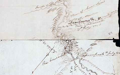
Detail from Moulton, Atlas, Map 62. Yale Collection of Western Americana, Beinecke Rare Book and Manuscript Library, Yale University.
Clark’s maps between Smith River and the Three Forks of the Missouri are among the least reliable of any he made, according to Robert Bergantino, and the above detail from his map for 16–21 July is typical. Clark’s “No. 31” and “No. 32,” both referring to “Points of Observation” where celestial observations were made, should have been shown upstream from the camp of 16 July 1805.
On the seventeenth the main party continued to see groves of quaking aspen along the river and its tributaries, and the next day, in the vicinity of Dearborn’s River, they observed several herds of bighorn sheep but, wrote Lewis, “they were all out of our reach on inaccessable clifts.”
Lewis took Lunar Distance observations near his camp below the rapids and then, about one mile above the rapid, took his observation of the sun’s Meridian Altitude. Afterwards, he wrote, they proceeded on, and “as the canoes were still heavy loaded all persons not employed in navigating the canoes wal[k]ed on shore.” Unfortunately,
the river clifts were so steep and frequently projecting into the river with their perpendicular points in such a manner that we could not pass them by land, we wer therefore compelled to pass and repass the river very frequently in the course of the evening.[3]When ascending a river, rather than engage in the futility of trying to paddle against the main current of the river, the party always stayed close to one bank or the other in order to pole or … Continue reading
Clark climbed a spur of a mountain that he “found to be highe & dificuelt of axcess, Containig Pitch Pine & Covered with grass.”[4]Clark’s “Pitch pine” would have been a superficial, shrubby look-alike to the species Pinus rigida, still commonly called pitch pine, which was native to the east from Maine and … Continue reading He left no hint as to which mountain he climbed, nor how far, nor what he learned from it, except that, as Indians had forewarned them, there was “Scercely any game to be Seen.” It was, as Sergeant Gass conceded, “a very desert looking part of the country.”[5]At the turn of the 19th century, “desert” denoted any dry, desolate, uninhabitable region, not just sand and cactus.
Lewis only observed angles to determine Lunar Distances, that were essential for the calculation of longitudes—the complicated exercises in spherical trigonometry that were to have been carried out by Ferdinand Hassler back home, but were never finished. Unfortunately, the observations Lewis made in the vicinity of Tower Rock were error-ridden. At PO No. 30, where he stopped at noon on the 16th, he calculated his latitude as 46°46’50.2″. Had his math been correct, he would have arrived at 47°14’52” N, which means his original result was 32.3 miles too far south. In contrast, Bergantino’s re-evaluation of PO 30 places it at 47°14’03” N, or 31.3 miles north of Lewis’s original calculation. That may not have been a serious mistake for that time, place, and purpose, but it could have meant disaster for a mariner at sea even then, and it would be utterly unacceptable for any practical purposes today.
The latitude 46°42’14.7″ that Clark wrote on the southeast side of the river was Lewis’s calculation from the observation he made at the PO he designated No. 33, but was properly No. 32. According to his journal entry for the 17th, that observation was taken one mile upstream from the previous evening’s camp at the foot of Pine Island Rapid. Using the angle Lewis observed, but making the calculations with the correct index error for the octant, yields a latitude of 47°10’50.5″, but since the octant could be read only to the nearest 30 seconds it should be given as 47°11′ North, which is 33 miles north of Lewis’s incorrectly calculated latitude of 46°42’14.57″. Besides, the true redetermined latitude of Lewis’s PO No. 32 was about one mile upstream of Pine Island Rapid; its actual latitude therefore was about 47°10′ N. In other words, Lewis’s calculated latitude is 32 miles south of the latitude when correctly calculated. The x at the “Place of observation” above the Dearborn River, 10 miles upriver from Tower Rock, is actually PO No. 33. There, on 18 July 1805, Lewis shot Lunar Distances again, but did not observe the Meridian Altitudes from which he could have determined latitude.
The most important element in this map is the label “Rocky Mountains” on this, the first of the four chains they expected to encounter, and the only one to which Clark ever gave a name. Either from oversight or because of miscommunication with Lewis, Clark did not show Tower Rock on this or any subsequent map. But the Pine Island Rapid was more significant in his mind as the most obvious feature of the Rocky Mountains’ eastern boundary. He referred to it a half-dozen times in his later reflections on the various practical routes between the Falls of the Missouri and Travelers’ Rest Creek.[6]See Moulton, Journals, 6:449, 473, 494; 8:104, 291, 9:337.
Tower Rock State Park
Figure 5
The Rock at the Gate
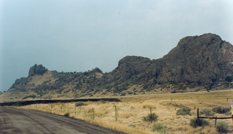
© 2001 VIAs Inc.
This view of Tower Rock was taken from the northeast side of the “handsome little plain” that surrounded it on three sides, which is now laced with access roads to the private homes that now occupy the riverbank, the old two-lane highway to the west of the rock, and near it on the west side Interstate 15 and the Hardy interchange (Exit 247). The normal elevation of the river’s surface in the vicinity of Tower Rock is approximately 3,370 feet above Mean Sea Level. The highest point on the ridge, at the south (photo left) end, is at 3,796 feet; the north end is about 100 feet lower. The ridge is a pyroclastic extrusion pushed up through the volcanic debris and modified by erosion over a period of millions of years. Overall, as Clark estimated on the same date from the perspective of his camp four miles downriver from here, “this Range of mountains . . . is about 800 feet higher than the Water in the river.” Indeed, the summits of the Adels average between 800 and 1,000 feet above the river.
Lewis’s estimate of the rock’s highest elevation was only about 25 feet short. But shod as he was in moccasins, he was hardly equipped to climb the highest pinnacle, so probably he was satisfied with reaching a point roughly due west of his campsite. Even if his view point was only about 200 feet above the river, he could still see five times farther (18.5 statute miles) than from the riverbank.
Figure 6
Surgical Scars
© 2003 Robert G. Rumney.
Terraces made by bulldozers, to keep rocks from rolling onto the Interstate highway.
It had once witnessed a major event in the progress of the Lewis and Clark expedition, but had kept the memory to itself in stony silence for 195 years. For many decades this rocky ridge was owned by the Montana Department of Transportation, which had blasted off some of its north end to be used as rip-rap for highway construction. Otherwise virtually worthless, by the year 2000 it had fallen into the DOT’s inventory of surplus property and, with the 150 acres of land it occupies, was set to be auctioned off to the highest bidder—to whom it could never whisper its old secret.
The rock’s monumental significance was forgotten for 200 years after Lewis exalted it. Nicholas Biddle, in his 1814 paraphrase of the captains’ journals, mentioned the rock along with Pine Island and the rapid, but neglected to repeat the name Lewis had given the rock. Even Gary Moulton wasn’t aware of it in 1987 when the fourth volume of his edition of the Journals of the Lewis and Clark Expedition was published. In fact, another three years passed before a woman named Cheryl Hutchinson, while reading through that volume, came upon Lewis’s description of the place and exclaimed to herself, “I know that rock! I look out at it every day from my kitchen window!” (Her home is a little beyond the lower right corner of Bob Rumney’s photo at the top of this page.) She immediately sought the opinion of geologist and Lewis and Clark historian Robert Bergantino, of the Montana Bureau of Mines and Geology, who enthusiastically confirmed her conclusion. This definitely was Lewis’s Tower Rock, fully as important, both historically and geologically, as Pompy’s Tower on the Yellowstone.
Ms. Hutchinson lent the great rock her own voice, let it tell its own story in Lewis’s words, and helped it rescue itself from the auctioneer’s hammer. Tower Rock was listed in the National Register of Historic Places in 2002.
Montana’s Legislature in 2003 passed an act making Tower Rock “a gift to future generations of Montanans in honor of the Lewis and Clark Expedition.” In 2004, the U.S. Board of Geographic Names adopted the captains’ names for the rapid and island, removing “Half-Breed” forever. Finally, in July, 2005, Tower Rock was dedicated as a state park by the Montana Department of Fish, Wildlife and Parks.
As a longtime resident of Hardy Creek, Ms Hutchinson has established a sympathetic relationship with her lithic neighbor. “We don’t know what the northern peak looked like 200 years ago,” she says, “but we do know the southern peak has changed dramatically. We know there have been several significant landslides, caused not only by the blasting but also from other nearby construction. I have talked with 1960s highway workers who personally witnessed almost avalanche-like activity on the southern peak. Even later, the vibration from 18-wheelers roaring across the I-15 bridge have caused more soil and rock to slide. And who knows what the railroad cars that rumbled by for 110 years did to the land above the tracks?[7]Track linking Helena with Great Falls was laid by the Montana Central Railroad in 1887, and ownership was eventually acquired by the Burlington Northern Santa Fe (BNSF). It has been out of service … Continue reading Bulldozers and other heavy equipment have done a lot of terracing because of the extensive land shifts.”[8]Cheryl Hutchinson, personal communication, 5 February 2007.
Adel Volcanics
Figure 7
Adel Volvanic Rock
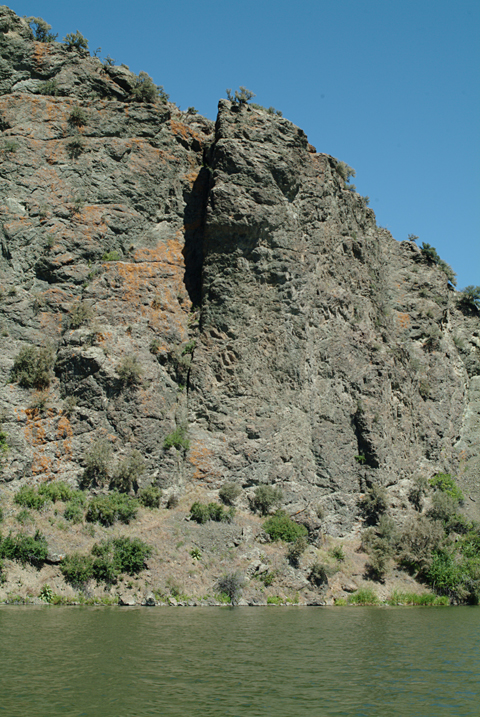
© 2007 VIAs Inc.
Immediately after setting out from the landing above the rapids on 17 July 1805, the river slowed and deepened, and the men plunged into the narrow, brooding canyon that rifts the Adel Volcanics. Clark wrote:
the river clifts were so steep and frequently projecting into the river with their perpendicular points in such manner that we could not pass them by land in some places both banks of the river are formed for a short distance of nearly perpendicular rocks of dark black grannite of great height.
Both Lewis and Clark were wrong to name the rocks here as granite. At that time neither man had any way of knowing that these mountains comprise a geologically unique segment of the Rockies now called the Adel Mountain Volcanics. Measuring more than 40 miles in length and 20 in width, they consist of the eroded remnants of volcanic eruptions that began about 75 million years ago and lasted for several million years.[9]“Cliffs High & Steep: Adel Mountain Volcanics,” in Montana Governor and First Lady’s Math and Science Initiative, http://opi.mt.gov/PDF/MathScience/MTScienceMathInitiative.pdf. … Continue reading As Professor Moulton notes, there is no granite in the Adel Volcanics but mostly lava breccias and ashfall tuffs. Moreover, they are not black but a mixture of “dark red, purplish-red, dark grayish-green, and dark gray.”[10]Journals, 4:397. Clark was correct in other details, however. There wasn’t much timber on the narrow banks except for some aspen, and even in the mountains beyond them the pine was sparse. Nor did they see any game except “some mountain rams or bighorned anamals.”


Tower Rock is a High Potential Historic Site along the Lewis and Clark National Historic Trail managed by the U.S. National Park Service. The site a Montana State Park.—ed.
Notes
| ↑1 | One degree of latitude at 47° north equals 69.08 statute miles; an arc minute (1/60th of a degree) equals 1.15 miles; an arc second equals 101.2 feet. |
|---|---|
| ↑2 | Editor Nicholas Biddle mentioned Pine Island in his 1814 paraphrase of the captains’ journals, but did not repeat their name for the rapid, so until after Thwaites’s publication of the original journals in 1904, no one could have known Lewis and Clark’s name for it. Sometime, probably late in the 19th century, for reasons now long forgotten, it came to be known as “Half Breed Rapid” (and island), a name that still appears on many recent maps. |
| ↑3 | When ascending a river, rather than engage in the futility of trying to paddle against the main current of the river, the party always stayed close to one bank or the other in order to pole or cordelle (rope) the canoes ahead. The current was generally strongest and the water deepest on the outside of a curve, so it was necessary to cross the channel downstream of every bend—and try not to lose too much headway in the process—to take advantage of shallower water, slower margins of the current, and eddies that briefly swirled upstream near the inside point. The process of then recrossing the current to get back to the preferred side of the river was abbreviated in the expression “doubling the point.” Lewis and Clark used “evening” in the contemporary Southern sense, meaning the time between noon and dark. Lewis confirmed this himself when he wrote, on August 23, 1805, that his hunters returned “about 2 in the evening.” |
| ↑4 | Clark’s “Pitch pine” would have been a superficial, shrubby look-alike to the species Pinus rigida, still commonly called pitch pine, which was native to the east from Maine and Ohio to Georgia and Kentucky. |
| ↑5 | At the turn of the 19th century, “desert” denoted any dry, desolate, uninhabitable region, not just sand and cactus. |
| ↑6 | See Moulton, Journals, 6:449, 473, 494; 8:104, 291, 9:337. |
| ↑7 | Track linking Helena with Great Falls was laid by the Montana Central Railroad in 1887, and ownership was eventually acquired by the Burlington Northern Santa Fe (BNSF). It has been out of service since 1997. The Great Falls-Helena section of Interstate 15 was built 1963 and 1972, partly paralleling the first paved highway through the canyon, which dates from the 1930s. |
| ↑8 | Cheryl Hutchinson, personal communication, 5 February 2007. |
| ↑9 | “Cliffs High & Steep: Adel Mountain Volcanics,” in Montana Governor and First Lady’s Math and Science Initiative, http://opi.mt.gov/PDF/MathScience/MTScienceMathInitiative.pdf. Accessed December 28, 2006. Breccias are rocks composed of angular fragments of igneous, metamorphic or sedimentary rock, often of various colors, embedded in a fine- to medium grained material. Ash fall tuff (pron. toof, from Italian tufo) is consolidated volcanic ash. Moulton, Journals, 4:397n. |
| ↑10 | Journals, 4:397. |