Clark’s Exit
On 1 August 1805, Clark and the expedition’s flotilla of eight dugout canoes pushed up the Jefferson River through “a verrey high mountain which jutted its tremendious Clifts on either Side for 9 Miles, the rocks ragide.” They emerged into a “wide exte[n]sive vallie,” and camped that night on the south side of the river, opposite the mouth of “R Fields Valley Creek”—today’s Boulder River.
Jefferson River Canyon
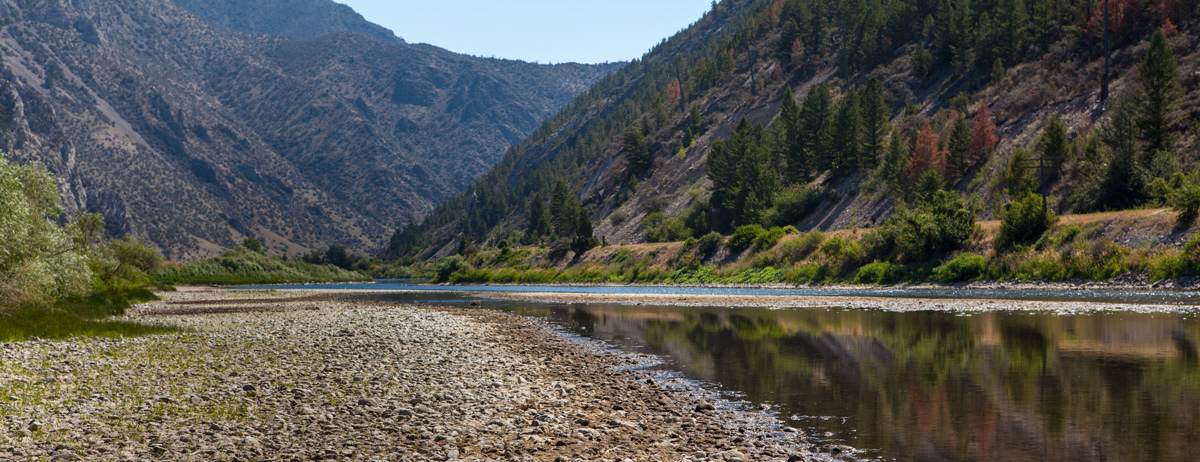
© 22 July 2013 by Kristopher K. Townsend. Permission to use granted under the Creative Commons Attribution-Share Alike 4.0 International license.
The canyon, which Clark labeled as the “3rd mountain gap” (see map below), is now called Jefferson Canyon, or Cardwell Canyon, where the Jefferson River snakes between the rugged mountains on the south side now called London Hills, and a little nameless group best known today as the site of Lewis and Clark Caverns State Park.[1]The name is purely commemorative, for neither Lewis nor Clark saw the cavern nor even suspected its existence. Two local hunters happened upon its entrance on the steep mountainside 1200 feet above … Continue reading The highest point on the right is London Peak, elevation 6326 feet.
The Jefferson River and its tributaries have wandered freely across the surface of this valley for perhaps thousands of years. Today, the mouths of Clark’s “R Fields” and “Frasures” creeks are only a little over one mile from one another, but as near as Clark’s courses and distances for 1 and 2 August 1805, can be retraced, those confluences were then twice that far apart. Moreover, the course of the Jefferson has followed its present south channel since about 1890. Before that, at least as far back as 1805, it followed the north channel, which by now it has largely abandoned, or uses as a slough to carry water only when the river is high. (This photo was taken in May of 2000, at the height of the springtime freshet.)
Lewis’s Arrival
Lewis and his three companions, Drouillard, Charbonneau, and Gass, reached this broad valley late on 1 August, after an exhausting trip over the London Hills northeast of Jefferson Canyon. The mountains, Lewis explained, were “extreemly bare of timber, and our rout lay through the steep and narrow hollows of the mountains exposed to the inte[n]se heat of the midday sun without shade or scarcely a breath of air.” His own discomfort was increased by the “slight disentary” he had been suffering for several days, which could only have been worsened by the “doze of glauber salts” he had taken that morning.
As was often the case with Lewis on otherwise bad days, he drew strength from nature through close observation and thoughtful inquiry. On this day he came upon two birds previously unknown to science, the blue grouse—which he studied and described in detail, and brilliantly compared from memory with “the common phesant of the Atlantic states”—and the pinyon jay, whose “note” or call he wrote down phonetically, “char âh’, char’âh, char âh’ as nearly as letters can express it.” The renewed buoyancy of his spirits smiled through his quickening pen: “after dinner we resumed our march and my pack felt much lighter than it had done about 2 hours before.”
“3d mountain gap”
Clark’s Sketch Map
To see labels, point to the map.
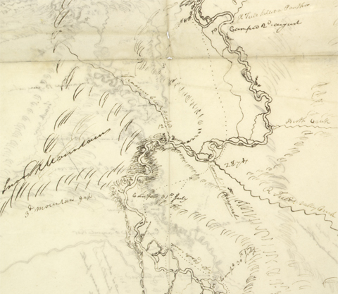
Beinecke Rare Book and Manuscript Library, Yale University
Moulton, Atlas, map 65
The dotted line labeled “Capt Clarks rout” when pointing to Clark’s sketch map marks the loop he took on 26 July 1805 when, accompanied by Robert Frazer and Reubin Field, and “with great difficuelty & much fatigue,” he climbed to the top of a mountain north of the river to get some idea of what lay ahead. Unfortunately, he mistook what later proved to be “R Fields Valley” for the continuation of Jefferson’s River, and he wasn’t quite far enough west to see anything more than the general trend of the valley he thought was Jefferson’s.
Lewis discovered the error five days later, at a similar cost in time and effort when, on Clark’s recommendation, he followed the same rough Indian path over the mountain and back to the river. The three men were “much exhausted by the heat of the day, the roughness of the road and the want of water.”
The “3d mountain gap” carries Jefferson’s River through a northwestern spur of the “Snow Mountains,” later named the Tobacco Root Mountains.
On 12 July 1806, en route with the canoes from the Three Forks of the Missouri to meet Lewis at White Bear Islands, Sergeant Ordway and his 9-man detail proceeded through the familiar canyon he mistakenly referred to as the “little gape [gate? gap?] of the mount.” and spent the night near the site of their camp of the previous 31 July 1805. Bull Mountain was the site of a major gold mine late in the 20th century (see Gold Mines on the Trail).
Whitehouse’s Descriptions
Private Joseph Whitehouse embellished the day’s record (1 August 1805) with more details in his own inimitable way. “We passed some very high Clifts, of Rocks which were in many places 1,200 feet high & – . . . About noon Captain Clark killed a mountain sheep or Ibex, out of a flock, which were on the side of Steep reddish hills or Clifts,” he wrote, continuing:
The remainder of the Flock . . . ran up the steep Clifts, out of Gunshot, and to such a heighth as is most incredible– The Mountain sheep that was killed, rolled down the Hill, and we got it.– We stopped at this place to dine, which was amongst the high Clifts, and it being Captain Clarkes birth day; he ordered some flour to be served out to the party, which with the mountain Sheep made us an excellent meal,– We proceeded on at 3 o’Clock P. M . . . we also passed . . . a very bad Rapid, at the upper end of an Island; where the Tow Rope broke of the Canoe, that Captain Clarke was on board & it had nearly upset.
Leaning hour after hour against the swift current, Clark and the crews of the eight canoes refreshed themselves now and then with the currants and chokecherries ripening within arm’s reach. Meanwhile, Lewis, Drouillard, Charbonneau, and Gass, traveling overland in search of the Shoshones they expected to find momentarily, were struggling across the “rough high range of mountains” north of the river.
Notes
| ↑1 | The name is purely commemorative, for neither Lewis nor Clark saw the cavern nor even suspected its existence. Two local hunters happened upon its entrance on the steep mountainside 1200 feet above the river in 1892. Six years later they and a group of their friends explored it, and decided to develop it as a natural attraction, but the Northern Pacific Railway laid claim to the land, and offered the property to the federal government as a park. In 1908 President Theodore Roosevelt proclaimed it “Lewis and Clark Cavern National Monument.” The land surrounding it—3,034 acres—was transferred to the State of Montana in 1937. Access development began, and for the safety and convenience of visitors electric lighting was introduced throughout the two-mile subterranean trail. In 2006 the trail route through the cavern was remapped in precise detail using a laser range finder, and subsequently a new lighting system was installed. |
|---|
Experience the Lewis and Clark Trail
The Lewis and Clark Trail Experience—our sister site at lewisandclark.travel—connects the world to people and places on the Lewis and Clark Trail.
![]()
This page was funded in part by a grant from the Montana Cultural Trust.
Discover More
- The Lewis and Clark Expedition: Day by Day by Gary E. Moulton (University of Nebraska Press, 2018). The story in prose, 14 May 1804–23 September 1806.
- The Lewis and Clark Journals: An American Epic of Discovery (abridged) by Gary E. Moulton (University of Nebraska Press, 2003). Selected journal excerpts, 14 May 1804–23 September 1806.
- The Lewis and Clark Journals. by Gary E. Moulton (University of Nebraska Press, 1983–2001). The complete story in 13 volumes.
This site is provided as a public service by the
![]()
Lewis and Clark Trail Alliance
with additional funding from the following:

