From a “high point of rocks,’ Clark’s Lookout, near today’s Dillon, Montana, on 13 August 1805, Clark descried a “gap at the place the river passes thro’ a mountain” 18 degrees west of south, an estimated 10 miles distant. That “gap” is still known as the Beaverhead Canyon Gateway. To Clark, as far as he knew then, it was but one more gate through the Rocky Mountains, which at Fort Clatsop that winter he would list as “the 4th Gap of the Mountain.”[1]In his list of “Estimated Distances in Miles Ascending the Missouri, Crossing the Rockey Mountains & decending the Kooskooskee, Louises River and the Columbia River of the remarkable places … Continue reading But as we know, he still had much to learn—the hard way.
Beaverhead Canyon
The Fifth Gate Through the Rockies
To see labels, point to the map.
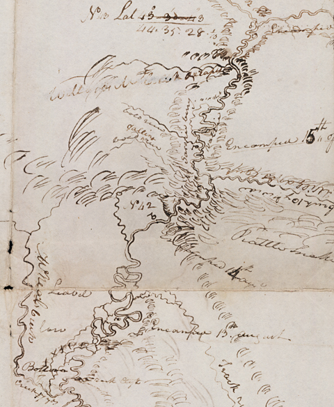
Detail from Atlas map 66. Beinecke Rare Book and Manuscript Library, Yale University.
The Beaverhead Canyon
The canyon that begins there, averaging 600 feet in depth, extends seven river miles south to another narrow unnamed portal formed by Pipeorgan Rock on the west side of the Beaverhead River, and Gallagher Mountain on the east. It was cut by the river through the northwest end of the Blacktail Mountains during the Pliocene, when a broad, gentle uplift with an eastern tilt occurred in the western U.S. It was at about the same time, give or take a million years, that the Gates of the Rocky Mountains were cut by the Missouri River.[2]J.W. Sears and P.C. Ryan, “Cenozoic evolution of the Montana cordillera: Evidence from paleovalleys” in R.G. Raynolds and R.M. Flores, Cenozoic systems of the Rocky Mountain region, … Continue reading The Blacktails merge with the southeast end of the Pioneer Mountains. By later standards both are part of the Rocky Mountains’ intricate matrix, but whether they really comprised a “chain” in Lewis and Clark’s terms is purely academic. The explorers could only judge from what they could see at water level, or at best a few feet above it.
On 15 August 1805, Clark paused at the “4th Gap,” or “Comsnt. of the Mountain” (Point of Observation No. 42) on the “Lard. side of the Missouri at the rattlesnake Clifts” to observe the meridian altitude of the sun’s lower limb with the octant from which he calculated the latitude as 44° 00′ 48.1, though Lewis guessed it ought to have been “44° 50′ or thereabouts.” Robert Bergantino has reassessed Clark’s work, and concluded the correct latitude would have been 45°07′, or roughly 80 miles north of Clark’s calculated latitude, and nearly 20 miles north of Lewis’s estimated latitude. Clark habitually shot the upper limb of the sun but thought he was shooting the lower limb. Calculating his octant reading based on that surmise puts the result at 45°07’N. But the actual latitude would have been about 45°07’45 degrees N, so it was a pretty good observation after all.
But Clark’s inventory of the chains and gates of the Rockies wasn’t finished yet. In his sketch map he showed another gap, about 7.4 miles farther upriver at “Clark Canyon” (not named for William, but for a later settler with the same surname) which he placed in his list as “the narrows of the 5th Mtn.” chain. At that riverine defile he “assended a mountain from the top of which I could See that the river forked near me.” He was looking down upon the site of the rendezvous place he and Lewis would call “Fortunate Camp.” On the following day the Corps’ long, and of late seemingly interminable, journey to the ultimate navigable limit of the Missouri River came to a welcome and auspicious end.[3]They couldn’t have known then that they were still 136.6 miles from the ultimate source of the Missouri, nor that it would be another 84 years before it was located.
Tensions Mount
The Gatepost
Olin D. Wheeler, The Trail of Lewis and Clark. See also Wheeler’s “Trail of Lewis and Clark”.
John Work, the famous Hudson’s Bay Company explorer and fur trader, camped at that place on 8 December 1831, noting that the Indians called the “steep rock” Cumcarny—a Shoshone Indian word properly pronounced coon-carny, meaning “campfire.” These were the narrows near which Lewis and the Shoshones with him, all en route back to the forks of the Jefferson on 16 August 1805, breakfasted on two deer Drewyer shot for them.[4]William S. Lewis and Paul C. Phillips, eds., The Journal of John Work (Spokane, Washington: Arthur H. Clark, 2006), 111. The first of Work’s journals to be published appeared in 1902; his … Continue reading
Warren Ferris, of the Northwest Fur Company, recognized Lewis’s landmark when he reached it on 24 August 1832: “We passed about fifteen miles through Horse Praire to the ‘Gates.’ . . . These ‘Gates’ are a high rocky conical elevation attached to a plain jutting into the bottom on one side of the river precisely opposite to the bluff rocky termination of a plain of considerable height, on the other side, but three or four hundred yards asunder; which gives to them the appearance of formidable gates, and they were thus named by Lewis and Clark.”[5]W. A. Ferris, Life in the Rocky Mountains, ed. Paul C. Phillips (Denver: Old West Publishing Company, 1940), 182. The bulk of Ferris’s journals of his Rocky Mountain exploration and trading … Continue reading
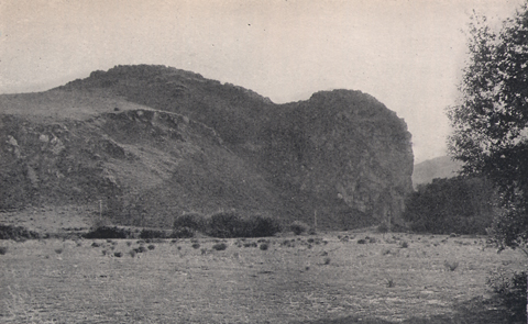
Clark and the canoeists camped for the night of 14 August 1805 in sight of this abrupt end of a spur of the Blacktail Mountains, which, early in the 20th century, was shown on maps as the real Beaverhead Rock (present-day Rattlesnake Cliffs).[6]At that time the landmark Sacagawea had recognized as “Beaverhead Rock” was called “Point of Rocks.” Citizens of Dillon took pains to point out the paradox to Olin Wheeler … Continue reading The men had faced discouraging, nearly overwhelming difficulties. Several lamed themselves “pushing up the Canoes” over shoals and rapids and around sharp oxbows. When the water was deep enough to float the boat he was in, Clark himself was obliged to “push a pole.” When they beached their dugouts at the end of the day, Clark estimated they were only a straight-line half mile from the “gap,” but two miles from it by water.
The energy and endurance which that sort of lopsided equation had daily drawn from every man since the day they left the Three Forks of the Missouri made it all the more urgent that they find Sacagawea’s people, buy some horses, and begin the portage to a navigable source of the Columbia River. By noon that day, everyone must have been on edge. “I checked our interpreter for Strikeing his woman at their Dinner,” snapped Clark.
What is more, this promontory and its environs, as well as the higher one opposite it on the west bank of the river, were teeming with prairie rattlesnakes. Here, as if this company of Argonauts were participants in some Odyssian parody, compelled by the gods to navigate between Scylla and Charybdis, both Clark and Sacagawea were nearly bitten by the dreaded monster’s votaries, Crotalus viridus viridus, the rattlesnake.
Order Becomes Chaos
By sheer coincidence—Lewis might have filed it in his own “chapter of accidents“—on the fourteenth a dense overlapping of discoveries brought their tenuous “four chains” concept of the Rocky Mountains to a climax, though neither could have recognized it until their rendezvous at Fortunate Camp on the seventeenth. As Clark was approaching this fifth (and final?) gap, Lewis was at the Shoshone Chief Cameahwait’s camp on the headwaters of the Columbia, bridging a critical information gap through the eloquent hands of sign-talker George Drouillard. In that way he learned a truth from Sacagawea’s brother which, he lamented with rueful understatement, fell far short of his expectation or wishes. Surely he must have anticipated that himself two days earlier at the moment he reached the dividing ridge, where he confronted “immence ranges of high mountains still to the West of us with their tops partially covered with snow.”
The truth was, this was not the easy portage to the Pacific Ocean they had expected from the beginning. Countless “chains” of mountains still intervened. Lewis and Clark, of course, paragons of the “can-do” soldier, were incredulous, and Clark set out on the 18th to see for himself “if those dificueltes presented themselves in the gloomey picture in which they painted them.” Their next two weeks were too crammed with work, too wrapped up in diplomatic maneuverings, their minds too preoccupied with sorting out options, and their spirits too darkened by the steadily encroaching end of the summer travel season, for either of the captains to indulge themselves the leisure to render into words any new feelings they might have had about the Rocky Mountains. There was much more to be learned about them.
With the fifth chain of mountains behind him, Lewis’s simple, orderly concept of the Rocky Mountains began to crumble. Yet somehow it persisted in his mind, and he was prepared to compare prior experiences with what was before him here. As he and his men set out into the “Snake Indian Cove” early on 11 August 1805, Lewis noted that “at the apparent extremity of the bottom above us two perpendicular clifts of considerable hight stand on either side of the river and appers . . . at this distance like a gate (emphasis added).”[7]Moulton, Journals, 5:66. The old idea still beckoned him. He himself would invoke it only twice more, both times nearly a year later, during his exploration of the shortcut between Travelers’ Rest and White Bear Island.
It was also embedded in Clark’s summary of “Estimated Distances” they had traveled, from one “remarkable place” to the next. One wonders what effect it might have had upon any travelers who tried to follow it within the next few decades, before the Northwest was re-mapped again and again, until modern highways imprinted new and relatively permanent scenic realities upon us all. Could they have made any sense of it in terms of these gates, mountain chains, and places where the rivers entered or left them? There is no answer to that, for Clark’s document was hidden from view and forgotten, with all the rest of the captains’ journals, for a hundred years.
Last Words
Yet it was Clark who had the last words on the subject. On 27 July 1806, en route down the Yellowstone River toward home, he looked back upon the mountains one more time, and then, with typical Clarkian detachment, wrote in his diary for that day: “when we pass the Big horn [River] I take my leave of the view of the tremendious chain of Rocky Mountains white with Snow, in view of which I have been Since the 1st of May last.” On that May morning he, Lewis, and the Corps had crossed the Columbia River and headed up a branch of the Walla Walla River, where they soon caught sight of some western slopes of the Rockies. Eighty-eight days later, and nearly 550 straight-line miles eastward, the Rocky Mountains disappeared beyond the western horizon. Finally, on the map that he prepared to accompany Nicholas Biddle‘s 1814 paraphrase of his and Lewis’s journals, he applied the name “Rocky Mountains” only to the easternmost of the approximately 35 distinct but still mostly conjectural mountain chains he had drawn on the manuscript map he completed in 1810.
The two dauntless explorers had lost count, and it didn’t really matter.
Notes
| ↑1 | In his list of “Estimated Distances in Miles Ascending the Missouri, Crossing the Rockey Mountains & decending the Kooskooskee, Louises River and the Columbia River of the remarkable places and Latitud partially anexed.” Moulton, Journals, 451. |
|---|---|
| ↑2 | J.W. Sears and P.C. Ryan, “Cenozoic evolution of the Montana cordillera: Evidence from paleovalleys” in R.G. Raynolds and R.M. Flores, Cenozoic systems of the Rocky Mountain region, Denver, Colorado, 1003), 289-301. The Pliocene was the last (most recent) epoch of the Tertiary Period. |
| ↑3 | They couldn’t have known then that they were still 136.6 miles from the ultimate source of the Missouri, nor that it would be another 84 years before it was located. |
| ↑4 | William S. Lewis and Paul C. Phillips, eds., The Journal of John Work (Spokane, Washington: Arthur H. Clark, 2006), 111. The first of Work’s journals to be published appeared in 1902; his journal from 18 August 1831, to 27 July 1832, was first published in 1923. 16 August 1805, was that unforgettable morning when Lewis and his three companions witnessed the revolting conduct of a group of grown men, otherwise self-possessed and congenial, whose bodies were silently screaming for nourishment. For the strength of the meat, the energy of the fat, and the salt of the blood. George Drewyer, in advance of the Shoshones and his companions, happened upon a deer for their breakfast, shot it, and quickly gutted it out, whereupon all the Shoshone men “dismounted and ran in tumbling over each other like a parcel of famished dogs each seizing and tearing away a part of the intestens which had been previously thrown out by Drewyer. . . . each one had a peice of some discription and all eating most ravenously.” One of them “had provided himself with about nine feet of the small guts one end of which he was chewing on while with his hands he was squezzing the contents out at the other.” Lewis looked on with astonishment and sympathy. “I really did not untill now think that human nature ever presented itself in a shape so nearly allyed to the brute creation. I viewed these poor starved divils with pity and compassion.” Presently Drewyer shot another deer, and “nearly the same seene was encored. a fire being kindled we cooked and eat and gave the ballance of the two deer to the Indians who eat the whole of them even to the soft parts of the hoofs.” Moulton, Journals, 5:103-04. |
| ↑5 | W. A. Ferris, Life in the Rocky Mountains, ed. Paul C. Phillips (Denver: Old West Publishing Company, 1940), 182. The bulk of Ferris’s journals of his Rocky Mountain exploration and trading sojourn, 1806-1830, were serialized in the Western Literary Messenger from 11 January 1843 until 18 May 1844. |
| ↑6 | At that time the landmark Sacagawea had recognized as “Beaverhead Rock” was called “Point of Rocks.” Citizens of Dillon took pains to point out the paradox to Olin Wheeler when he came through in about 1902. Hence the photo. |
| ↑7 | Moulton, Journals, 5:66. |