Upper Missouri River Breaks
28 miles northeast of Winifred, Montana
(view west, upstream)
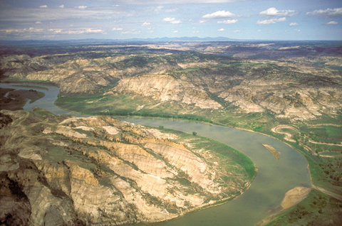
© 2000 Airphoto—Jim Wark.
The explorers’ grasp of the geography of the interior of the Northwest continued to evolve. At water level they estimated the distances between riverside landmarks and recorded their compass bearings, which were logged in daily lists of “courses and distances.” On 26 May 1805, for instance, they traveled 22¾ miles in twenty-one courses pausing briefly at the end of the eleventh course. For no known reason, they dubbed a creek meandering into the Missouri River (in the far right of the above photo), “Windsor’s Creek.” Since steamboat days, this creek has been known as Cow Creek. Evidently, Richard Windsor had not yet distinguished himself as a member of the Corps of Discovery, although ten days after they left that eponymous landmark behind he came close to historical immortality by being the second soldier to perish on the expedition, by plummeting some 90 vertical feet into Marias River.
The Upper Missouri River Breaks
Looking around, the men of the Corps of Discovery were fascinated by the varied textures, shapes and colors of the 200- to 300-foot cliffs that defined the river’s immediate borderlands. They noticed that the black rock they had previously seen had given way to soft, light sandstone overlaid by “a hard freestone of a brownish yellow colour.” They were passing through a flicker of geological time, the rising and falling of rivers large and small, the slow ebbs and flows of glaciers, eons ago. With the eyes of a river-bound eastern plantation owner, Clark judged from all he could see that “this Countrey may with propriety . . . be termed the Deserts of America, as I do not Conceive any part can ever be Settled, as it is deficent in water, Timber & too Steep to be tilled.” In those days the word “desert” denoted any land that was apparently useless, whether or not it consisted only of sand and cactus.
The captains also studied the western horizon from the summits of riverside promontories. On this day, from the highest point on the right side of the river near the center of this photo, Lewis thought he glimpsed the snow-capped and sun-glinted Rocky Mountains for the first time. His next thought was of “the difficulties which this snowey barrier would most probably throw in my way to the Pacific,” although he was willing to expect “a good comfortable road untill . . . compelled to beleive differently.” His mixed feelings were premature. What he saw (on the horizon in this photo) was an outlying island range known today as the Highwood Mountains, nearly a hundred miles east of the Rocky Mountain front, plus part of the isolated Big Belt range. He couldn’t yet see the Bitterroot Mountains, that “snowey barrier” that would force them all to the brink of despair. Twice.
Nez Perce Crossing
Cow Creek and Missouri River
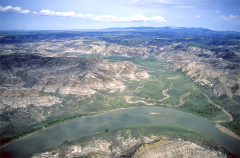
© 2000 Airphoto—Jim Wark.
Fording places were numerous at and near this bend in the Missouri, and the Cow Creek valley was mostly level, flat and wide. Consequently, for perhaps thousands of years, huge herds of bison crossed the river here twice a year, on their journeys from winter to summer ranges and back. They didn’t mind having to wade the creek 31 times in the first 15 miles, at which point their trail turned west and took them to the high plains north of the Missouri River.
On the horizon across the right half of the photo, 25 miles to the northeast, are the Little Rockies, an isolated 300-square-mile group of buttes, of which the highest tops out at 5,720′ above Mean Sea Level. Faintly visible on the horizon at left are the Bear Paw Mountains, about 50 miles a little west of north. They measure about 40 miles east-to-west, and 20 miles north-to-south. One of them reaches an elevation of 6,916′ MSL. The average elevation of the surrounding, mostly treeless and grassy, flat glacial plains is about 2,500-3,000′ MSL.
In late September 1877, the several bands of Nez Perce Indians whose chiefs had refused to leave their traditional homelands in southern Idaho and move to the pitifully inadequate reservation on the Clearwater River, crossed the Missouri River here and pressed on northward, drawn toward Canada by the hope of freedom. The U.S. Army caught up with them for the last time at the eastern foot of the Bear Paw Mountains. After a five-day siege, and beguiled by empty promises from Colonel Nelson Miles, Chief Joseph capitulated, vowing to “fight no more, forever.” Immediately the nearly 260 remaining survivors–men, women and children, of all ages–were transported to a camp in Oklahoma, where many of them, including every new-born baby, died of either malaria or malnutrition within the first year or two of their imprisonment. Ironically, one of the deceased claimed to be the proud Nez Perce son of William Clark, Tzi-kal-tza (also known as Halaftooki), said to have been sired by Clark with a daughter of Red Grizzly Bear during the Corps of Discovery’s month-long respite in May-June of 1806.
Defining Breaks
Missouri River Breaks
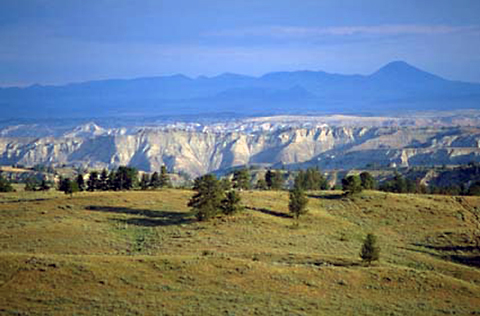
Wikimedia Commons, courtesy of US Bureau of Land Management.
In 1804 through 1806 Lewis and Clark called all rough or relatively precipitous elevations, wherever they saw them, “broken” lands; the topography along this 149-mile stretch of the Wild and Scenic Missouri River was clearly the worst they had ever seen. By 1820, according to the Oxford English Dictionary such terrain was described as “breaks,” meaning “rough, irregular country” or “broken country.” Subsequently (1840-50), broken lands and breaks were subsumed under the French expression mauvaises terres, translated as “badlands,” and defined as “extensive tracts of severely eroded, uncultivable land characterized by uneven rocky terrain and sparse vegetation” (OED), as found in Montana, Wyoming, Nebraska and the Dakotas. At the opening of the 20th century, Webster’s International Dictionary of the English Language (Supplement, 1902) defined “breaks” more precisely as “a line of cliffs, and associated spurs and small valleys, at the edge of a mesa.” The now definitive Dictionary of American Regional English (Vol. 1, 1985) cites a 1932 source that says the noun is applied to “a series of ridges and valleys running down from a bench or any higher country into the plain,” and notes that the word is found “in the strip of the Far West between Dakota and Arizona, sometimes as a proper noun.”
Notwithstanding the negative opinions of Lewis and Clark toward the viability of this land, the mesas (Spanish for “tablelands”) that are fringed by the Upper Missouri River Breaks are economically important to the region. Ranchers and farmers who live on the mesas among the breaks are permitted by the Bureau of Land Management to graze a total of more than 10,000 head of cattle per year on federal land within the Monument. Lewis and Clark could not have envisioned the growth of cattle-ranching into a way of life that would become an iconic, romantic Western manifestation of the American Dream.
The Steamboat Era
Woodhawk Creek
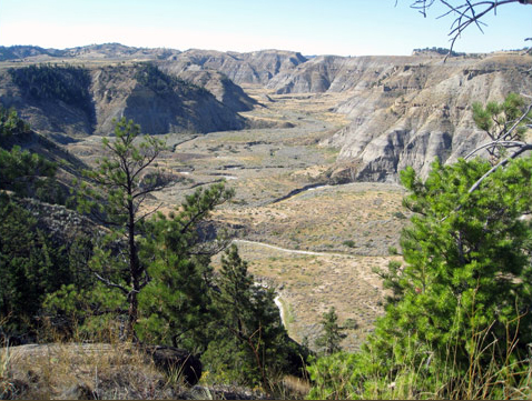
National Park Service, courtesy of Stephanie Martin.
Steamboat service for passengers and freight began working its way up the Missouri in the 1820s, reached the mouth of the Yellowstone in 1832, and the end of the line at Fort Benton in 1860, where the last steamboat docked in 1890, permanently superseded thereafter by transcontinental railroads. Steamboat commerce supported two other industries. One was overland hauling in sturdy wagons drawn by teams of oxen. Typically, low water from late summer until mid-autumn made Cow Creek temporarily the end of the line, and freight had to be trucked overland to Fort Benton for transshipment to widely scattered markets. The other related occupation was woodcutting–to fuel the boilers that generated the steam to turn the side or stern paddle-wheels. Steamboats had to maintain top speed much of the time when headed upriver, which required captains to stop up to several times daily to collect fuel. On average, the dual fireboxes and boilers of most steamboats burned nearly one cord of wood per hour–a stack 4 feet high, 4 feet wide, and 8 feet long. In June 1866 seven steamboats were docked at Fort Benton at one time, and that level of traffic held until water-level of the Missouri required
During the steamboat era the canyon pictured above was known as Woodhawk (“wood seller”) Creek. It meets the Missouri almost directly across from the mouth of Cow Creek. With numerous boats on the river daily or weekly, the requirements of steamboats devoured the useable resource very quickly. Obviously it was hard work in canyons like this, so woodcutters had to work their way farther and farther from the river to meet the need. It was dangerous, too. Early on, Indians were inclined to kill woodhawks who trespassed on their lands.
Today’s National Monument
Early in January 2001, one hundred and ninety-six years after Lewis and Clark expressed their shared opinion as to the worthlessness of the breaks, their perfectly reasonable snap judgment was officially replaced by a code of 20th-century environmental values. On 17 January 2001, President Bill Clinton signed a proclamation creating the Upper Missouri River Breaks National Monument, which encompasses nearly 586 square miles (375,000 acres) bordering both sides of 149 miles of the Missouri River, as well as numerous tributaries such as Arrow Creek, Antelope Creek and Cow Creek. Much of it is inaccessible to the majority of overland tourists, so those who have the time to float the Wild and Scenic Missouri River corridor get the same view of the breaks that initially impressed Lewis and Clark, as well as the passengers and crews of the many steamboats that plyed the upper reaches of the river as far as Fort Benton, Montana, during the second half of the 19th century.
According to the BLM’s inventory of natural resources, the rivers and tributaries, their riparian zones, and the mesas and breaks are homes to 60 species of mammals–including the Expedition’s prized discovery, the bighorn sheep (Ovis canadensis), that thrives on and near those cliffs that fringe the mesas–233 different birds, 49 varieties of fish, and 20 different amphibians and reptiles. The Upper Missouri River Breaks National Monument still teems with life.
Experience the Lewis and Clark Trail
The Lewis and Clark Trail Experience—our sister site at lewisandclark.travel—connects the world to people and places on the Lewis and Clark Trail.
![]()
Discover More
- The Lewis and Clark Expedition: Day by Day by Gary E. Moulton (University of Nebraska Press, 2018). The story in prose, 14 May 1804–23 September 1806.
- The Lewis and Clark Journals: An American Epic of Discovery (abridged) by Gary E. Moulton (University of Nebraska Press, 2003). Selected journal excerpts, 14 May 1804–23 September 1806.
- The Lewis and Clark Journals. by Gary E. Moulton (University of Nebraska Press, 1983–2001). The complete story in 13 volumes.
This site is provided as a public service by the
![]()
Lewis and Clark Trail Alliance
with additional funding from the following:

