On 19 May 1805 the expedition camped on the east side of the neck, or “gouge,” in the Missouri River where Musselshell River joins it, just out of the photo at left. It had been an exhausting day. “The river”—the Missouri, that is–”was croked, rappid and containing more sawyers,” Lewis complained, “than we have seen in the same space” since they passed the Platte River.
Chased and Bitten
To top it off, earlier in the day, when Lewis’s dog Seaman had swum “as usual” into the river to retrieve a beaver one of the men had shot, the big, wounded rodent bit the dog’s hind leg, severing an artery. “It was with great difficulty that I could stop the blood,” Lewis wrote. “I fear it will yet prove fatal to him.” Fortunately it did not.
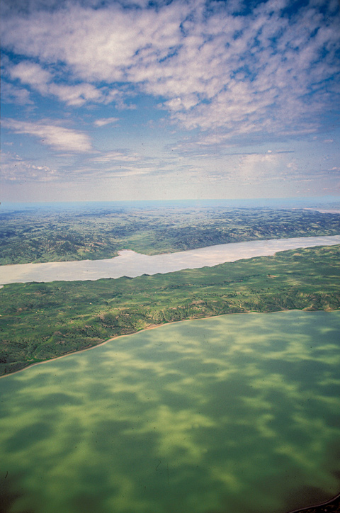
Lewis remarked that the water of the Missouri had become semitransparent, “but still retains it’s whitish hue.” The photograph captures it at a moment when a buttermilk sky dapples both lake and land with shadows, and at an angle that tints the water with a rich green. All the journalists crooned about the beauty and fertility of the land they entered in May 1805, but returning here in the pouring rain on 1 and 2 August 1806, Lewis took no pains to remark on what must have been a muddy, drab and dismal landscape.
Today, the expedition’s campsite here lies fifty feet beneath the surface of sluggish Fort Peck Lake, which was created when Fort Peck Dam was completed in 1940.
Charles M. Russell NWR
UL Bend of the Missouri
© 2000 Airphoto—Jim Wark.
The 1,700-square-mile Charles M. Russell National Wildlife Refuge extends for 125 miles westward along the Missouri River beginning at Fort Peck Dam. Within it, nearly 100 river-miles from the dam, is the 31-square-mile UL Bend National Wildlife Refuge[1]The UL Bend NWR, which was established in 1967, is believed to have been named for the UL Ranch, established in 1902 by the U. L. Cattle Company of Great Falls, Montana. Richard Aarstad et al. … Continue reading, a designated wilderness established primarily to provide wetlands for migratory birds and waterfowl. It is also a re-introduction site for the black-footed ferret (Mustela nigripes), an endangered species and the only ferret native to North America–although no member of the Corps of Discovery ever reported seeing one. Correspondingly, prairie dog towns are being increased in order to satisfy the ferrets’ appetite for prairie dog meat. The endangered pallid sturgeon is being re-introduced into this stretch of the Missouri River.[2]http://www.fws.gov/Refuges/profiles/index.cfm?id=61529 (retrieved 8 September 2008).
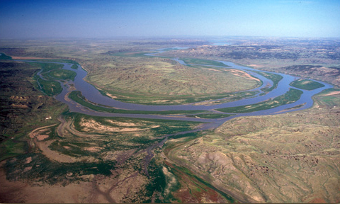
The Musselshell River
Musselshell River
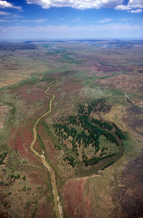
© 2000 Airphoto—Jim Wark.
Jim Wark shot these views of the Musselshell and the UL Bend almost exactly 201 years after Lewis and Clark first saw them, but except for the higher water level today of Fort Peck Lake–the reservoir impounded by Fort Peck Dam–the scene has changed very little since then. The land encompassed by the photos on this page has a population density averaging one person for every three to four square miles. Sacagawea‘s River, which enters the Musselshell from the west (photo left) is difficult to point out in this photo. Long known simply as Crooked Creek, the name Lewis and Clark gave it was officially restored during the Bicentennial.
By mid-day on 19 May 1805 Clark noticed that he was making better time on shore with two companions than the “Perogues”–did he mean the red and white ones, or the dugout canoes, or both?–which were struggling against the current, so he took time to climb the highest hill he could see, and from it studied “the meanderings of the Missouri for a long distance,” noting especially the mouth of the “M. Shell R” and “a high mountain in a westerley direction, bearing S. S W. about 40 or 50 miles distant”–the Highwood Mountains.
The next day they continued advancing by means of the “toe rope.” When ashore they stepped gingerly through carpets of prickly pears cactus, and at dinner brushed swarms of blow flies from their meat. Shortly before noon they “arrived at the entrance of a handsome bold river which discharges itself into the Missouri on the Lard [larboard, left side of the river facing upstream].”
this stream we take to be that called by the Minnetares the . . . Muscleshell River;[3]The Hidatsa name was Mah-tush,-ah-zhah, or shell river. If it be the same, of which I entertain but little doubt, it takes it’s rise, by their information in the 1st Chain of the Rocky Mountains at no great distance from the Yellow stone river, from whence in it’s course to this place it passes through a high and broken country pretty well timbered, particularly on it’s borders, and intersperced with handsome fertile plains and medows.
The Musselshell River doesn’t originate in the “1st Chain of the Rocky Mountains,” but about 100 miles north of the Middle Yellowstone on the north slope of the Crazy Mountains. But Lewis couldn’t have known that. He and Clark had yet to thread their way through the supposed four chains of the Rockies that John Evans had sketched from Indian information. However, Lewis expressed some legitimate doubts about what the Indians around Fort Mandan had told him about the river. Instead of “well timbered country” around the river’s confluence with the Missouri, Lewis saw nothing more than “a few scattering small scrubby pine and dwarf cedar on the summits of some of the highest hills.” Nine-tenths of the country was “wholy destitute of timber of any kind, covered with a short grass, arromatic herbs [sagebrush], and the prickly pear.” The captains dispatched a small party to explore the lower eight miles of the Musselshell. Their report is difficult to reconcile with the testimony of these photographs: The Musselshell’s bottoms were “well stocked with Cottonwood timber of tollerable size, & lands of excellent quality.”
The Muscle Shell river falls into the Missouri 2270 miles[4]By today’s measurement, the Missouri having been shortened and stabilized by dams during the 20th century, the Musselshell joins it 1,867 river miles above the Mississippi, according to the … Continue reading above it’s mouth, and is 110 yards in width, it affords much more water than streams of it’s width generally do below, it’s courant is by no means rappid, and from the appearances it might be navigated with canoes a considerable distance; it’s bed is coarse sand and gravel principally with an occasion mixture of black mud; it’s banks abbrupt and about 12 feet high yet never appear to overflow; the waters of this river is of a greenish yellow cast, much more transparent than the Missouri, which last is also much more transparent than below but still retains its whiteish hue and a proportion of it’s sedement. . . .
The hunters returned this evening and informed us that the country continued much the same in appearance as that we saw where we were or broken, and that about five miles [above] the mouth of shell river a handsome river of about fifty yards in width discharged itself into the shell river on the Stard. or upper side; this stream we called Sâh-câ-gar me-âh or bird woman’s River, after our interpreter the Snake woman.
Lewis may have overestimated the average width of the river–or he may have been measuring its flood plain. Today, except during the brief spring runoff, the breadth of its water seldom exceeds thirty feet throughout most of the river’s 365 sluggish miles. Its headwaters merge at the confluence of its North and South Forks in a valley north of the Crazy Mountains; the source of the Yellowstone River is 100 miles beyond that, at the southern boundary of Yellowstone National Park. The Musselshell’s mainstem flows at a leisurely pace through wide-open, relatively unpopulated prairies for 360 miles to join the Missouri at the center of the UL Bend, which is clearly visible near the horizon in this photo.
Heavy Winds
On the night of 21 May 1805, 20 miles up the Missouri from the Musselshell’s mouth, the men endured an element of Northern Plains scenery that has challenged the endurance of every traveler and every resident–the prevailing northwest wind. Lewis wrote:
The wind which was moderate all the fore part of the day continued to encrease in the evening, and about dark veered about to N. W. and blew a storm all night,, in short we found ourselves so invelloped with clouds of dust and sand that we could neither cook, eat, nor sleep; and were finally compelled to remove our lodge [and camp] about eight o’Clock at night to the foot of an adjacent hill where we were covered in some measure from the wind by the hills. several loose articles blown over board and lost. our first station was on a bar on Stard. opposite the lower point of a small Island, which we now called windy Island.[5]Two “Winding Islands” are shown on Atlas map 59.
From Discovering Lewis & Clark from the Air
Photography by Jim Wark
Text by Joseph Mussulman
Reproduced by permission of Mountain Press
Notes
| ↑1 | The UL Bend NWR, which was established in 1967, is believed to have been named for the UL Ranch, established in 1902 by the U. L. Cattle Company of Great Falls, Montana. Richard Aarstad et al. Montana Place names from Alzada to Zortman (Helena: Montana Historical Society Press, 2009), 272. |
|---|---|
| ↑2 | http://www.fws.gov/Refuges/profiles/index.cfm?id=61529 (retrieved 8 September 2008). |
| ↑3 | The Hidatsa name was Mah-tush,-ah-zhah, or shell river. |
| ↑4 | By today’s measurement, the Missouri having been shortened and stabilized by dams during the 20th century, the Musselshell joins it 1,867 river miles above the Mississippi, according to the River Mile Index of the Missouri River, Water Resources Division, Montana Department of Natural Resources and Conservation (January 1979), 35. |
| ↑5 | Two “Winding Islands” are shown on Atlas map 59. |