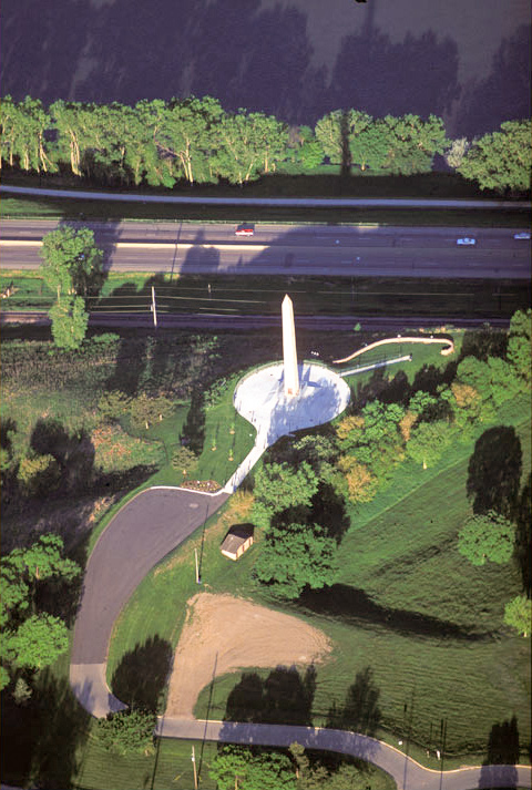
The hundred-foot-tall sandstone obelisk in the photo was dedicated to Sergeant Floyd’s memory on Memorial Day 1901.
On Saturday 18 August 1804, Sgt. Charles Floyd wrote his ninety-seventh and last consecutive daily journal entry: “our men Returnd and Brot with them the Grand Chief of the ottoes and 2 Loer ones and 6 youers [warriors?] of thare nathion.” The man refereed to was deserter Pvt. Moses Reed, who had deserted on 4 August 1804 and this afternoon was tried and convicted despite the three Otoe chiefs’ pleas for leniency. Reed was sentenced to run the gauntlet four times, then dishonorably discharged.
It was Meriwether Lewis‘s thirtieth birthday, so “the evening was Closed with an extra Gill of Whiskey & a Dance untill 11 oClock.” The next morning, twenty-two-year-old Charles Floyd “was taken violently bad with the Beliose Cholick and is dangerously ill—we attempt in Vain to releive him, I am much concerned for his Situation . . . nature appear exosting fast in him.”
On 20 August 1804, the Corps proceeded thirteen miles, while young Floyd quickly grew worse. A little past noon they landed, and presently Floyd said, “I am going away.” He died, perhaps of perotinitis from a ruptured appendix, “with a great deel of Composure.” His comrades buried him atop a nearby bluff overlooking the Missouri River, “with the Honors of War, much lamented.” Clark continued, “After paying all the honor to our Decesed brother, we Camped in the mouth of floyds river . . . a butifull evening.”
First White Settlers
Sioux City, Iowa
View westward, up the Missouri from above the city center
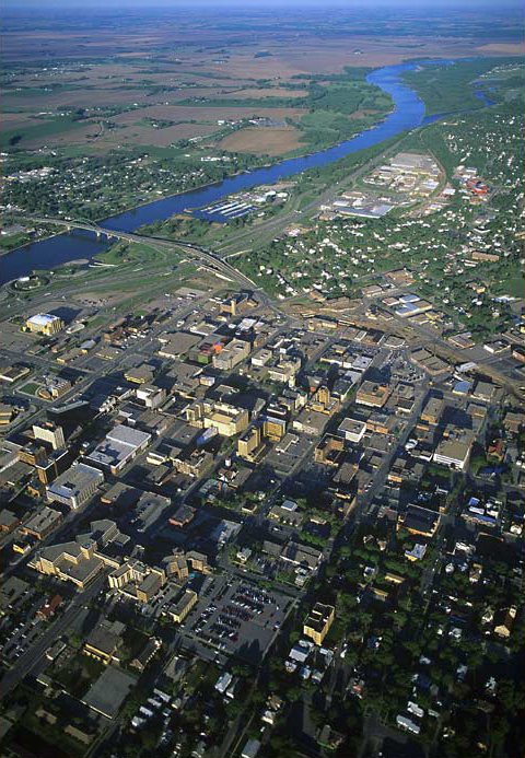
© 2000 Airphoto—Jim Wark.
Jim Wark’s aircraft is approximately 1200 feet above the center of Sioux City. When viewing it in Google Earth, look for Wesley Parkway (U.S. 77) where it crosses first over Interstate 29, and then over the Missouri River on Veterans’ Bridge. Floyd’s Monument is nearly 3 miles south of this interchange, on the east side of the river after it makes a turn southward, beyond the lower left corner of the photo above.
In the upper right corner the Missouri River is joined by a tributary from the north (picture right), which since the late 18th century has been known as the Big Sioux River. Captain Clark simply called it the Sioux River on his 1810 map, but was told by his interpreter Pierre Dorion (the younger, c. 1780-1814) that it was the Red Stone River. Clark described it as follows:
This River is about the Size of Grand river and as Mr. Durrien our Souex intpt. [interpreter] says ‘is navagable to the falls [at Sioux Falls, South Dakota] 70 or 80 Leagues [210 or 240 miles] and above these falls Still further,’ those falls are 200 feet or there abouts and has two princepal pitches, and heads with the St. peters [Minnesota River] passing the head of the Demoien [Des Moines River], on the right below the falls a Creek [Split Rock] coms in which passes thro Clifts of red rock which the Indians make pipes of,[1]Donald Dean Parker, ed., The Recollections of Philander Prescott, Frontiersman of the Old Northwest, 1819-1862 (Lincoln: University of Nebraska Press, 1966), 130-39. and when the different ‘nations Meet at those quaries all is piece [peaceful].
The white population of the homelands claimed by the Iowas, Otoes, Sauks and others in 1804 was almost too small to count when the Lewis and Clark expedition hove to at the mouth of the little stream they would name for the late Sergeant Charles Floyd.
Up until that time, a handful of Frenchmen had scrabbled about for furs, dodged irritable Indians, and took small pleasures in defying the few Spanish bureaucrats and frontier soldiers who occasionally wandered into Upper Louisiana.[2]The Spanish authorities established the boundary between Upper and Lower Louisiana at 36° 35′ North latitude–at the settlement of New Madrid. They named St. Louis the capital of Upper … Continue reading After the French ceded entire territory of Louisiana to Spain in 1762, the Spanish provincial authorities, seated in New Orleans, found that keeping those remote French fur trappers and traders under control wasn’t worth the trouble. Local Spanish authorities did, however, issue more or less generous land grants to selected applicants such as the renowned Daniel Boone and his extended family, but not above the Missouri, except at Les Petites Côtes at the center of the St. Charles District. However, when they got wind of President Jefferson’s plan to explore their territory, the Spanish sprang into (largely misdirected) action.
The first white settlers in the vicinity of what was to become Sioux City, Iowa, were William Thompson and his brother, who settled at the foot of Floyd’s Bluff in 1848 and, with a surfeit of egotism, named their place Thompsontown. But either it was a nuisance of a long name, or their dreamtown wasn’t in the right place, or the Thompson boys just weren’t the sort of entrepreneurs who could build a town. In any case, nothing happened there. The Thompsons’ ambitious episode was typical of the countless “paper towns” that sprang up magically along the frontier, but got no farther than their names on worthless official documents.
Next came Theophile Bruguier (1813-1896), a native of Montreal, Canada and a sometime trader and interpreter for John Jacob Astor’s American Fur Company. In 1836 the company sent him to Fort Pierre (across the Missouri from today’s Pierre, South Dakota), where he learned the Dakota language and gained the respect of the Sioux, especially the Yankton Sioux and their leader, Chief War Eagle. He married two of the chief’s daughters–at the same time, consistent with Indian tradition–who between them bore him 13 children. Astor’s fur company folded in 1842, so Bruguier settled down with his family near the mouth of the Big Sioux River, to subsist on farming and trading. In 1852 he sold 160 acres of his land near the mouth of Floyd’s River to his old friend and fellow French-Canadian, the American Fur Company veteran Joseph Lyonnais (1818-189?).
John Cook’s Choice
Sioux City was founded by John K. Cook (1799-1885), an Oxford-educated Englishman who emigrated to America as a physician, but soon abandoned his original calling and seized a more appealing opportunity. He became a surveyor. As a contractor for the U.S. government, he was first assigned to Illinois, but in 1846 was dispatched to the State of Iowa to survey land along its western boundary. In 1854 he persuaded Joseph Lyonnais to sell him 80 acres (1/8 of a square-mile section)–now known as downtown Sioux City–for $37.50 per acre, an extravagant sum, considering most of the rest of Iowa Territory was exchanging ownership at an average rate of $1.25 an acre.
But Cook, with his practiced eye, could recognize prime land with a promising urban future if anyone could. So he platted a modest little town and, as a member of a “Sioux City Company” that included the state’s two senators and a few other power-brokers, set about building a town to go with the name. With the benefit of its members’ political clout the Company opened a federal land office by October of ’55, and a post office by the following Christmas, which brought the city’s total number of buildings to seven. By the spring of ’56 there were 150 Sioux Cityans to welcome the first steamboat from St. Louis. At about that same time, the town was officially incorporated by the state legislature and designated as the seat of Woodbury County. During that same Missouri River navigation season three more steamers landed at Sioux City, giving significant boosts to local and regional commerce. By early July of the following year there were 28 arrivals at the levee, fostering commensurate surges of business along with insuppressible civic pride and joy. Just imagine it: Only 8 or 9 days from St. Louis, whereas it took Lewis and Clark 112 days (minus 14 days spent on parleys with Indian tribes and leaders, plus some time off for rest, or for logistical reasons) to cover the estimated 879 miles from St. Charles, Missouri, to Floyd’s River. Sioux City and its 464 residents were securely and profitably linked with the rest of the United States.
Crash!
The scene was set for a new kind of global crisis that now seems distressingly familiar, and always surprising, to us all. In the autumn of 1857 the troubled European monetary arena, combined with the bullish U.S. economy–fueled by fraudulent banking practices compounded by reckless land speculation in Iowa and other frontier regions–and the burgeoning interconnectedness of the worldwide marketplace, brought about the financial crisis that quickly became the first-ever worldwide fiscal Rubicon.
“When will we ever learn?”
From Discovering Lewis & Clark from the Air
Photography by Jim Wark
Text by Joseph Mussulman
Reproduced by permission of Mountain Press
Notes
| ↑1 | Donald Dean Parker, ed., The Recollections of Philander Prescott, Frontiersman of the Old Northwest, 1819-1862 (Lincoln: University of Nebraska Press, 1966), 130-39. |
|---|---|
| ↑2 | The Spanish authorities established the boundary between Upper and Lower Louisiana at 36° 35′ North latitude–at the settlement of New Madrid. They named St. Louis the capital of Upper Louisiana. |
Experience the Lewis and Clark Trail
The Lewis and Clark Trail Experience—our sister site at lewisandclark.travel—connects the world to people and places on the Lewis and Clark Trail.
![]()
Discover More
- The Lewis and Clark Expedition: Day by Day by Gary E. Moulton (University of Nebraska Press, 2018). The story in prose, 14 May 1804–23 September 1806.
- The Lewis and Clark Journals: An American Epic of Discovery (abridged) by Gary E. Moulton (University of Nebraska Press, 2003). Selected journal excerpts, 14 May 1804–23 September 1806.
- The Lewis and Clark Journals. by Gary E. Moulton (University of Nebraska Press, 1983–2001). The complete story in 13 volumes.
This site is provided as a public service by the
![]()
Lewis and Clark Trail Alliance
with additional funding from the following:

