The lower reaches of the Missouri River already had a long history of European presence when Lewis and Clark came through. One of their most helpful informants in St. Louis had been James Mackay, a veteran in the Missouri river fur trade and, since 1795, a manager for the Spanish-controlled Missouri Fur Company. Mackay also gave Lewis copies of maps for the lower and middle Missouri made by one of his employees, a Welshman named John Evans.
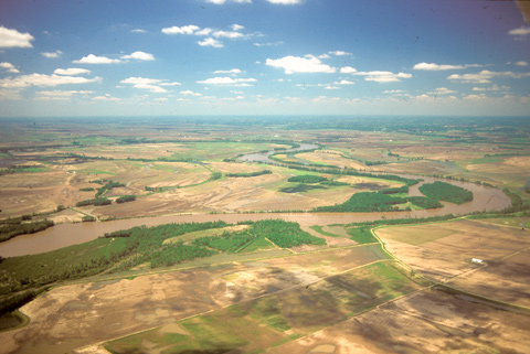
On 16 June 1804, Clark took a long walk through this “butifull extensive Prarie” to look for an old fort on Evans’s map, built by the French thereabouts more than eighty years earlier. “I could See no traces of a Settlement of any kind,” Clark concluded. Nevertheless, the party spent three days here making new oars, making rope, and hunting.
Two years and three months later, on 16 September 1806, only seven days from St. Louis and the end of their journey, they paddled through this same scene in less than one day—a day “excessively worm and disagreeable, so much So that the men rowed but little,” Clark wrote. Moreover, the navigator—presumably Pvt. Pierre Cruzatte—considered this stretch to be the worst on the river. That morning they encountered “a large tradeing Perogue” commanded by Joseph Robidoux, who three years before had established a trading post at the future location of St. Joseph, Missouri, forty-five miles upriver. The next day they met John McClellan, an old Army buddy of Lewis’s, heading a large trading party bound for Santa Fe to “exchange his merchindize for Silver & gold of which those people abound.” McClellan told them “the people in general in the United States were concerned about us as they had heard that we were all killed then again they heard that the Spanyards had us in the mines &C.”
In 1881 the steamboat Malta struck a snag in the river bend shown in the photo, and sank, leaving its name on the little farming community nearby (roughly beneath the photographer’s plane)—Malta Bend, Missouri, originally settled in 1867. Today the Missouri shows little trace of the treachery its snags, shifting sands and unpredictable currents imposed on the expedition’s little fleet and the steamboats that came after, and well-groomed farmlands flourish where Clark saw seas of rich tall grass. However, its banks still cave in, and mosquitoes and ticks remain relatively “noumerous & bad.”
From Discovering Lewis & Clark from the Air
Photography by Jim Wark
Text by Joseph Mussulman
Reproduced by permission of Mountain Press