Jim Wark
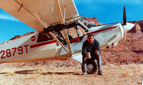
© 2000 Airphoto
I am an aviator, a mining engineer and a photographer, in that order. Or maybe it’s the other way around. My life’s work has been in aviation and earth sciences, and combining these interests with an inherited instinct for photography has fulfilled my deepest ambition. My Christen Husky airplane has prowled North and Central America, from the Arctic shores of Alaska to the tropical jungles of Costa Rica, and from the remote and harsh Ungava Peninsula of Labrador to the balmy Island of Granada.
On the Morning of Friday, May 14, 1999, I began my westward retracing of the Lewis and Clark route from St. Louis to the Pacific Ocean in my Christen A-1 Husky, a single-engine, high-wing, bush-type airplane. The day marked the 195th anniversary of the departure of the Corps of Discovery from this point. I had spent five months planning and plotting the route, and I had entered geographic coordinates of known Corps of Discovery campsites and points of interest into the airplane’s Global Positioning System (GPS). I also entered many potential camping sites. The nights spent camping with my airplane are treasured times, and I put much thought into selecting locations.
The National Park Service reckons the distance of the Lewis and Clark Trail at 3,700 miles. My GPS flight plan showed 2,473 miles. The point-to-point traverse of the GPS-planned route eliminated many miles of river and trail meandering, so the distances are not necessarily at odds. The trip took seven flying days, with eighty hours of flight time. For Lewis and Clark, the time in actual travel was twelve months. In 2001, at the urging of Dr. Mussulman, I flew the eastern portion of the Lewis and Clark route, as well as all the principal side journeys.
My trips over the Lewis and Clark Trail produced a total of 3,182 images, all of which were shot with Leica 35mm cameras and Fuji Velvia film. As has been the case with nearly all of my aerial photos, the heights at which the pictures were shot varied from 500 to 3000 feet, with most taken between 1000 and 1500 feet. The average person’s view of the earth from six miles high in a commercial airliner, or even from one mile up in a small plane, bears no resemblance whatsoever to the experience of flying alone, low and slow, over the incredible, changing texture of the earth below. It is touching the face of the land and sensing its texture, habitations and geology. It is a close encounter with weather and terrain as a single element.
My single-engine airplane is loaded with a large collection of cameras, lenses, camping equipment and provisions capable of sustaining an adventure of several weeks. The only replenishments needed are aviation fuel and fresh water. Nights are spent sleeping under the wing—or sometimes on the well-worn couch of a friendly small-airport manager. A normal working day is eight hours of flying, resulting in 300 to 400 photos per day. There are times when fair weather prevails for weeks at a time. At other times, low clouds and storms have kept me grounded for several days at one camp or another.
There are countless opportunities to capture images from the air of human activity and achievement, but the biggest rush comes from nature: A special light, a dramatic cloud, an unusual expression of geology, a craggy peak, a reflecting lake, a splendid palate of texture and color. A juxtaposition of any of these things, including human activity, is what makes aerial photography a unique experience for the photographer and for those who view it.
Jim Wark was the 2006 recipient of the first annual Epson Professional Photographers’ award. In March 2007, two of his photos were among 103 chosen from 9,968 world-wide entries for the San Diego Lyceum’s 2007 “Art of Photography” exhibition.
To date, Jim’s published works are:
- A Field Guide to Sprawl, with text by Dolores Hayden (128 pages, 75 aerial photos), $24.
- America, Flying High, with text by the photographer (650 pages, 600 aerial photos), $25.
- Colorado: An Aerial Geographer of the Highest State, with text by Tom Huber (140 pages, 110 aerial photos), $45.
- Discovering Lewis & Clark From the Air, with text by Joseph Mussulman (261 pages, 111 aerial photos), $25 hardcover; $22 paper.
All are available direct from the photographer. To order, email [email protected], or call 719.545.1051. Add $5 for postage.
See also Jim’s on-line Airphoto North America gallery, containing almost 10,000 images selected from his 100,000-image stock library.
Featured Photographs by Jim Wark
John Collins
Private
by Barbara Fifer, Joseph A. Mussulman
He had gotten off to a bad start, but apparently, the captains, or at least Clark, saw something in him that was worth saving. They would name Idaho’s Lolo Creek, Collins Creek.
Sgt. Floyd’s Memorials
Much Remembered
by Joseph A. Mussulman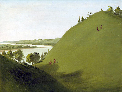
Floyd’s grave became a conspicuous point and a historic shrine on the Lewis and Clark trail almost immediately after the expedition was over. The American artist George Catlin painted Floyd’s Bluff in 1832, with the original cedar marker still in place.
Larocque’s Yellowstone Journey
One year before Clark
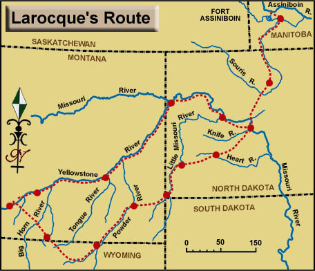
The fourth literate explorer to go up the Yellowstone (and before Clark) was François-Antoine Larocque, who is important to the story of Lewis and Clark on the Middle Missouri for several reasons.
Lisa’s Fur Trade Forts
And the deaths of Potts and Drouillard
by W. Raymond Wood
Manuel Lisa’s men at Fort Raymond not only encouraged the Crows to come trade with them, but they set out parties to trap beaver on their own. It was the latter effort that led to hostilities with the Blackfeet that affected Potts, Drouillard, and Colter.
Living on the Highline
by Rick Newby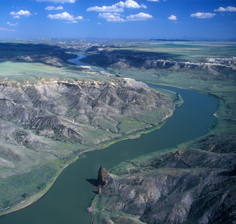
Montana’s Upper Missouri landscape has seen enormous changes in the past two centuries and, at the same time, retained its remoteness, rugged character, and wild beauty.
Gold Mines on the Trail
by Joseph A. Mussulman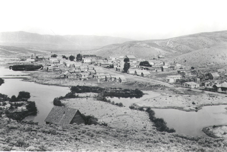
In 1862, a prospector named John White and his partners arrived at a creek previously named for Alexander Willard of the Corps of Discovery. White hit pay dirt on one of the sandbars in the creek. Plenty of other gold-hungry pilgrims were near enough to respond within weeks.
Frontier Ranching
Changes since Lewis and Clark
by Rick Newby
On the Upper Missouri, the changes since the years Lewis and Clark traveled here have been less obvious perhaps, but no less remarkable.
Jefferson’s Monticello
Source and paradigm
by Joseph A. Mussulman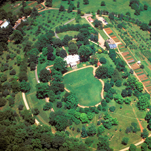
After some eight months of planning and discussion, President Thomas Jefferson handed his twenty-eight-year-old secretary, Captain Meriwether Lewis, a letter containing instructions for the conduct of one of the most significant undertakings in American history.
Pittsburgh by Air
Golden triangle
by Joseph A. Mussulman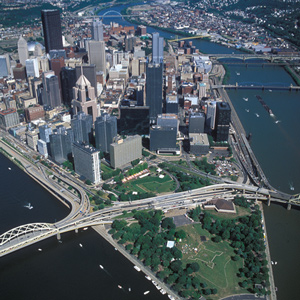
The Monongahela River joins the Allegheny River at the apex of Pittsburgh’s “golden triangle” to form the river called Ohio—an Iroquois word meaning “big and beautiful.” After the Revolutionary War, Pittsburgh quickly grew into a gathering-place and jumping-off point.
Foggy Ohio Mornings
Weather report
by Joseph A. Mussulman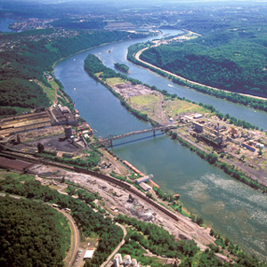
They camped for that night somewhere on the big island now known as Brown’s. When darkness fell the two canoes, which carried most of Lewis’s most valuable supplies, were still behind. “Ordered the trumpet to be sound[ed],” he wrote, “and they came up in a few minutes.”
Wheeling
"Point of Embarkation"
by Joseph A. Mussulman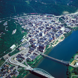
Lewis had contracted with a wagoner to haul a substantial part of his baggage from Pittsburgh to Wheeling. In 1803 there were only a few thousand miles of decent wagon roads in the seventeen states, and Wheeling was the western terminus of one of the newest of them.
Louisville
Kentucky recruits
by Joseph A. Mussulman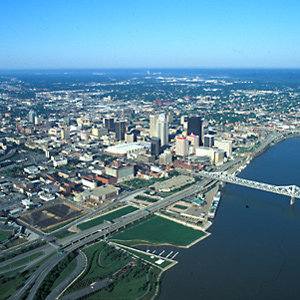
Clark was waiting with seven more recruits who would become permanent members of the contingent soon to be known as the Corps of Volunteers for North Western Discovery.
The Wabash River
Familiar water
by Joseph A. Mussulman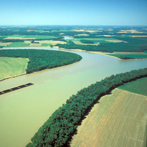
Lewis, Clark, and their crew must have passed the mouth of the Wabash about 5 November 1803. The captains had crisscrossed the area in the course of their military duties, and in 1792 Clark had gained one of his first experiences in river navigation.
The Mouth of the Ohio
Meeting of the waters
by Joseph A. Mussulman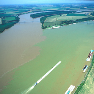
On the evening of 14 November 1803, Lewis and Clark camped on the point between the Ohio and Mississippi Rivers. By now they had rowed, poled, dragged, and occasionally sailed their boats a total of 981 miles.
The Grand Tower
Demons
by Joseph A. Mussulman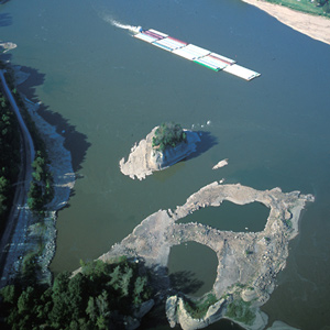
In 1673 French explorers Père Marquette and Louis Joliet listened to local Indians’ warnings about this place and erected a cross atop the ninety-foot-high rock to disempower the demons said to be lurking in the treacherous whirlpool at its base.
Winter at Wood River
12 December 1803–13 May 1804
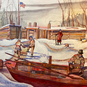
During the winter of 1803–04, everything had to come together: the enlisted men, the boat men, the provisions, and the transfer of Louisiana to the United States.
La Charrette
Outpost
by Joseph A. Mussulman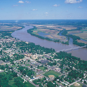
On 25 May 1804, about forty river-miles above St. Charles, the expedition camped near a small village at the mouth of a creek called Charrette. Its seven French families had arrived only a few years before. The family of Daniel Boone moved there sometime after 1804.
The Osage River
"a delightfull prospect"
by Joseph A. Mussulman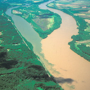
On 1 June 1804, the expedition arrived at the mouth of the Osage River, one of the major Indian trail intersections on the lower Missouri. From the height on the point, Clark wrote: “I had a delightfull prospect of the Missouries up & down, also the Osage R. up.”
Jefferson City
"Nightengale" song
by Joseph A. Mussulman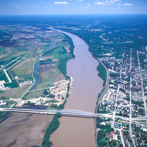
On Sunday, 3 June 1804, the expedition left its camp at the mouth of the Osage River and proceeded five miles upstream to the mouth of the Moreau River. There, Clark wrote, he and George Drouillard, “Saw much sign of war parties of Inds. having Crossed from the mouth of this Creek.”
Arrow Rock
Handsome spot
by Joseph A. Mussulman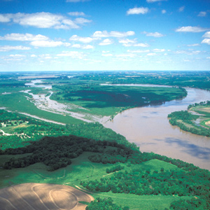
It was a hard and dangerous day’s work getting past the wooded bluff called Arrow Rock on 9 June 1804. It was a “disagreeable and Dangerous situation,” wrote Clark.
Malta Bend
"butifull prarie"
by Joseph A. Mussulman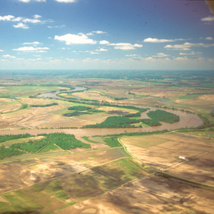
On 16 June 1804, Clark took a long walk through a “butifull extensive Prarie” to look for an old fort on Evans’s map, built by the French thereabouts more than eighty years earlier. The party spent three days here making new oars and ropes, and hunting.
St. Joseph by Air
Bad medicine
by Joseph A. Mussulman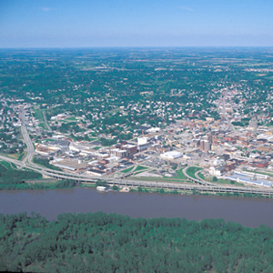
Pvt. Robert Frazer came close to being the expedition’s first fatality, for he was “verry Sick, struck with the Sun.” Probably his affliction would be diagnosed today as either heat exhaustion or sunstroke.
Big Nemaha River
High ground
by Joseph A. Mussulman
The Corps camped for the night of 11 July 1804 on “Newfound Island” to “rest the men who are much fatigued.” Five men explored the Big Nemaha River and climbed to the top of “a high artificial Noal”—an Indian burial site—to gain “an emence, extensive & pleasing prospect of the Countrey around.”
Omaha-Council Bluffs
Nobody home
by Joseph A. Mussulman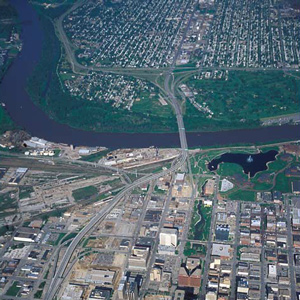
On 23 July 1804, the captains sent Drouillard and Cruzatte to an Otoe Indian village to invite the chiefs to come hear of the change of national allegiance from Spain to the United States and to learn “the wishes of our Government to Cultivate friendship with them.”
Willard’s Bad Day
And a dreadful hurricane
by Joseph A. Mussulman
Willard had to walk back 3 miles to get his tomahawk. On his way back, he dropped his rifle in the water, and he couldn’t find the weapon in the deep mud. On that same day, Clark took note of “much fallen timber, apparently the ravages of a dreadful haricane.”
The Little Sioux River
A froth of feathers
by Joseph A. Mussulman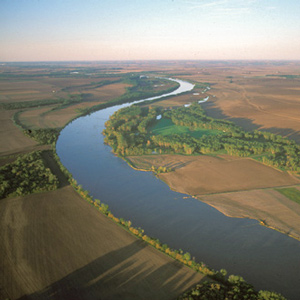
A highlight of 8 August 1804 was a profusion of feathers floating like a froth on the water. The feathers went on for three miles “in such quantities as to cover pretty generally sixty or seventy yards of the breadth of the river.”
Blue Lake Meander
Iowa meander
by Joseph A. Mussulman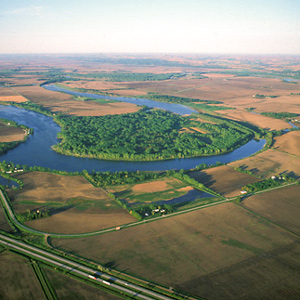
This oxbow was once part of the main channel of the Missouri, but by 1804 the river had already cut it off, turning it into a lake “6 leagues [eighteen miles] around.”
Floyd’s Monument by Air
"Much Lamented"
by Joseph A. Mussulman
On 20 August 1804, the Corps proceeded thirteen miles, while young Floyd quickly grew worse. A little past noon they landed, and presently Floyd said, “I am going away.”
Elk Point
Names
by Joseph A. Mussulman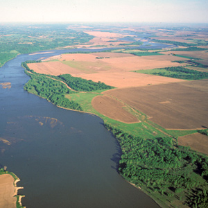
In the vicinity of Elk Point, South Dakota, the captains found a variety of unfamiliar minerals, including what Clark believed were arsenic and cobalt. “Capt. Lewis in proveing the quality of those minerals was near poisoning himself by the fumes & taste.”
Spirit Mound by Air
"Unusual spirits"
by Joseph A. Mussulman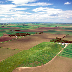
On 25 August 1804, obedient to Jefferson’s instruction to observe Indians traditions, monuments and landmarks, Lewis and Clark went inland to visit a “conic form” rising from the plain.
Sandbar Hazards
Knotty problem
by Joseph A. Mussulman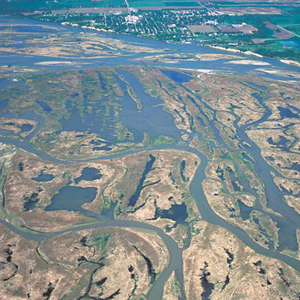
The task of piloting the expedition’s boats efficiently through the Missouri’s windings and blind leads was the principal responsibility of Pierre Cruzatte who, as a riverman, earned the respect and confidence of every member of the party.
Fort Randall Dam
Wolf tricks
by Joseph A. Mussulman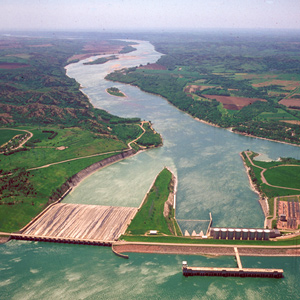
Here, Sergeant Gass went out with one of the hunters to retrieve the meat and hide of a buffalo the man killed the previous evening. The hunter had left his hat on the carcass “to keep off the vermin and beasts of prey,” apparently believing the scent of a human would scare them away”
Big Bend of the Missouri by Air
Around the bend
by Joseph A. Mussulman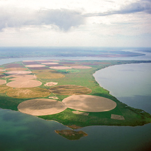
They paced off the distance across “the gouge,” wrote Clark, and found it to be about a mile and a quarter; he estimated the distance around the oxbow to be thirty miles.
Pierre by Air
Standoff
by Joseph A. Mussulman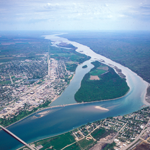
Lewis and Clark first met the Teton Sioux on 25 September 1804. One of Jefferson’s primary political objectives for the expedition was to create a peace treaty and trade agreement them, the most potent military and economic force on the lower Missouri.
Bad ‘humered’ Island
Change of heart
by Joseph A. Mussulman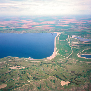
On the evening of 25 September 1804 after a negative encounter with the Lakota Sioux, the Corps camped on a nearby island Clark called “bad humered Island.” The next morning, the Indians had a change of heart.
Fort Yates
Hunting party
by Joseph A. Mussulman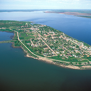
The Corps observed an Indian strategy for hunting game. As men on horseback herded pronghorns—”goats or Antelope,” Clark called them—into the river, boys swam among them and killed some with sticks, while others on shore shot them with bows and arrows.
The Knife River Villages
Marketplace
by Joseph A. Mussulman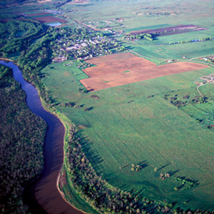
Reaching the mouth of the Knife River on 27 October 1804, the expedition arrived in the midst of a major agricultural center and marketplace for a huge mid-continental region. The five permanent earth lodge communities there offered a panorama of contemporary Indian life.
Fort Mandan by Air
"most perfect harmony"
by Joseph A. Mussulman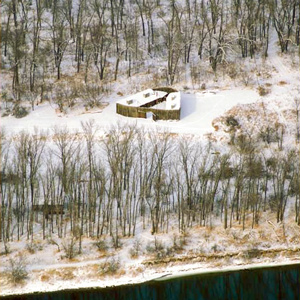
Lewis attested that his men were “in excellent health and sperits, zealously attached to the enterprise, and anxious to proceed; not a whisper of murmur or discontent to be heard among them, but all act in unison, and with the most perfect harmony.”
Yellowstone Mouth by Air
"Long wished for spot"
by Joseph A. Mussulman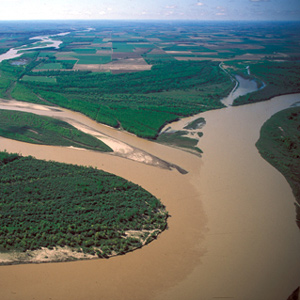
“I ascended the hills,” Lewis wrote, “from whence I had a most pleasing view of the country, particularly of the wide and fertile vallies formed by the Missouri and Yellowstone Rivers.”
Culbertson, Montana
Abundance
by Joseph A. Mussulman
Somewhere in this vicinity, on 29 April 1805, Lewis shot his first grizzly bear and promptly began his detailed study of the fascinating species. Other game was astonishingly abundant, too.
May 19, 1805
Seaman bitten
After morning fog clears, the enlisted men tow the boats up the Missouri stopping about seven miles below the Musselshell River in Eastern Montana. A grizzly bear shot in the heart runs for 1/4 miles before falling, and Lewis’s dog Seaman is bitten by a wounded beaver.
May 20, 1805
"Sâh-câ-gar me-âh or bird woman's River"
The captains name a creek Blowing Fly after the blowflies that often congregate on raw meat and open wounds. At the mouth of the Musselshell, they explore and take celestial observations. A tributary of the Musselshell is named “Sâh-câ-gar me-âh [Sacagawea] or bird woman’s River”.
Elsewhere, the barge, that headed down the Missouri from Fort Mandan on 7 April 1805, arrives in St. Louis.
Charles M. Russell NWR
Missouri Breaks
by Joseph A. Mussulman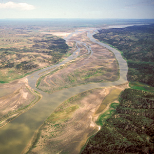
The wind against them again on 25 May 1805, the Corps had to tow their boats with ropes. Lewis observed, “the water run with great violence, and compelled us in some instances to double our force in order to get a perorogue or canoe by them.”
Into the Breaks
Fred Robinson Bridge to Judith Landing
by Joseph A. Mussulman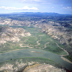
In 1804-5-6 Lewis and Clark called all rough or relatively precipitous elevations, wherever they saw them, “broken” lands; the topography along this 149-mile stretch of the Wild and Scenic Missouri River was clearly the worst they had ever seen.
The Judith River
by Joseph A. Mussulman
“at the distance of 2½ miles passed a handsome river which discharged itself on the Lard. side, I walked on shore and acended this river about a mile and a half in order to examine it”
The Grand Natural Wall
"walls of tolerable workmanship"
by Joseph A. Mussulman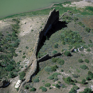
“As we passed on it seemed as if those seens of visionary inchantment would never have an end; for here it is too that nature presents to the view of the traveler vast ranges of walls of tolerable workmanship.”
The White Cliffs
by Joseph A. Mussulman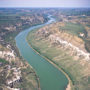
Under cloudy skies on the morning of 31 May 1805, the expedition “proceeded at an early hour,” and roped their flotilla of six cottonwood dugout canoes and two big pirogues into one of the most famous riverscapes on the Missouri.
Citadel Rock
"Steep black rock"
by Joseph A. Mussulman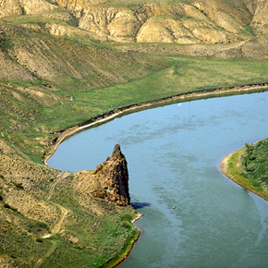
Clark remarked on this “high Steep black rock riseing from the waters edge” as they passed it on 31 May 1805, but he did not give it a name. Citadel Rock, so called during the steamboat era for its fortress-like presence, was an igneous intrusion into a layer of sandstone.
Decision Point by Air
At the mouth of the Marias
by Joseph A. Mussulman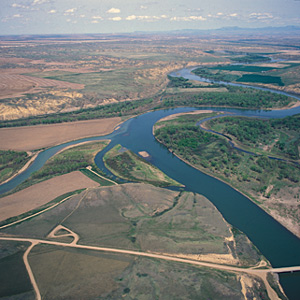
In the late afternoon of Sunday, 2 June 1805, the Corps of Discovery “came too on the Lard. side in a handsome bottom of small cottonwood timber opposite to the entrance of a very considerable river.” They now faced a crucial question: Which river was the Missouri?
The Great Fall by Air
"Sublimely Grand"
by Joseph A. Mussulman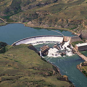
Shortly before noon on the 13 June 1805, Lewis’s ears “were saluted with the agreeable sound of a fall of water,” which “soon began to make a roaring too tremendious to be mistaken for any cause short of the great falls of the Missouri.”
Rainbow Falls by Air
"Pleasingly beautifull"
by Joseph A. Mussulman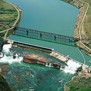
After briefly contemplating the Crooked Falls on 14 June 1805, Lewis followed the sound of “a tremendious roaring” to “one of the most beautifull objects in nature,” a fifty-foot-high cascade “with an edge as regular and as straight as if formed by art.”
The Sun River by Air
"Curious adventures"
by Joseph A. Mussulman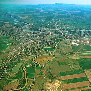
The day’s “succession of curious adventures wore the impression on my mind of inchantment,” he mused. “It now seemed to me that all the beasts of the neighbourhood had made a league to distroy me.”
Crooked Falls by Air
A "thousand conjectures"
by Joseph A. Mussulman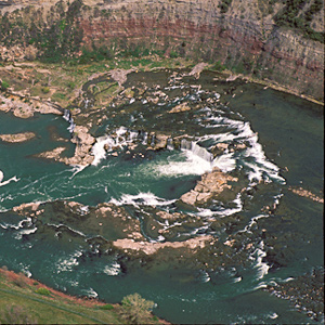
After passing “one continued rappid and three small cascades of abut for or five feet each,” Lewis “arrived at a fall of about 19 feet,” which he suitably named “the crooked falls” and proceeded to describe its geometry.
Lower Portage Camp
Good news, bad news
by Joseph A. Mussulman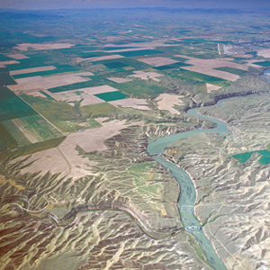
By the evening of 15 June 1805, Clark had gotten the canoes and the white perogue as close to the Great Falls as possible, and the next afternoon Lewis joined him at the “lower portage camp,” a mile below the mouth of Belt Creek.
Tower Rock
First Gate of the Rocky Mountains
by Joseph A. Mussulman, Robert N. Bergantino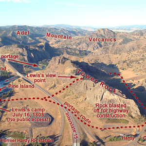
“at this place there is a large rock of 400 feet high wich stands immediately in the gap which the missouri makes on it’s passage from the mountains.”
Oxbow Bend
Land and water
by Joseph A. Mussulman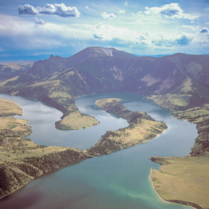
On 19 July 1805, Lewis ‘doubled’ around Oxbow Bend, then 30 feet lower and maybe one-fourth as wide as it is today. Behind the river’s curve, an ancient landmark on the Indian Old North Trail, still stands out.
Gates of the Mountains
The second gate
by Joseph A. Mussulman, Robert N. Bergantino
Late in the day on 19 July 1805, Lewis and his party entered a canyon between “the most remarkable clifts that we have yet seen.” They seemed to rise “from the waters edge on either side perpendicularly to the hight of 1200 feet.”
The Headwaters by Air
Essential point
by Joseph A. Mussulman
Upon the Corps’s arrival at this confluence on 25 July 1805, Lewis quickly recognized it as “an essential point in the geography of this western part of the Continent.”
Three Forks of the Missouri
Essential geographic point
by Joseph A. Mussulman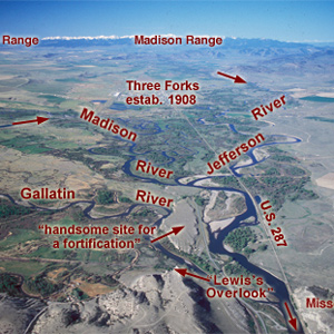
Lewis and his canoes slowly approached the forks, “the current still so rapid that the men are in a continual state of their utmost exertion to get on, and they begin to weaken fast from this continual state of violent exertion.” He described the “extensive and beatifull plains and meadows.”
The Jefferson River
Third gap
by Joseph A. Mussulman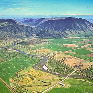
On the first of August 1805, Clark and the expedition’s flotilla of eight dugout canoes pushed up the Jefferson River through “a verrey high mountain which jutted its tremendious Clifts on either Side for 9 Miles, the rocks ragide.”
The Jefferson Canyon
The fourth mountain gate
by Joseph A. Mussulman, Robert N. Bergantino
On 1 August 1805, Clark and the expedition’s flotilla of eight dugout canoes pushed up the Jefferson River through “a verrey high mountain which jutted its tremendious Clifts on either Side for 9 Miles, the rocks ragide.” They emerged into a “wide exte[n]sive vallie.”
The Tobacco Root Mountains
Beautiful prairies
by Joseph A. Mussulman
“We proceeded on and passed a large beautiful bottom,” wrote Pvt. Joseph Whitehouse on 2 August 1805, “and Prairies lying on both sides of the River.” On each side of the valley, Sergeant Gass observed, “there is a high range of mountains . . . with some spots of snow on their tops.”
The Beaverhead River
Home ground
by Joseph A. Mussulman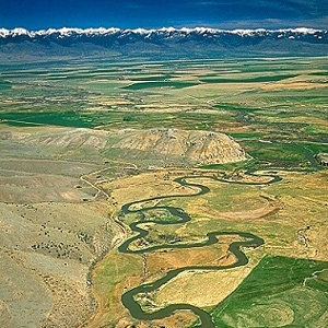
With what satisfaction and relief Lewis must have written, on 8 August 1805: “The Indian woman [Sacagawea] recognized the point of a high plain to our right which she informed us was not very distant from the summer retreat of her nation.”
Fortunate Camp
Western road
by Joseph A. Mussulman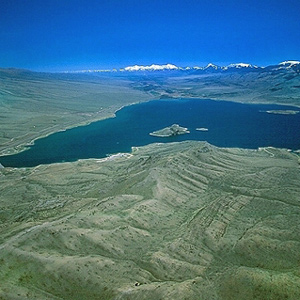
Today the confluence of the Beaverhead River and Horse Prairie Creek is submerged at left of the large island (photo center) in Clark Canyon reservoir, beneath eighty feet of water when the reservoir is full.
Lemhi Pass by Air
Division point
by Joseph A. Mussulman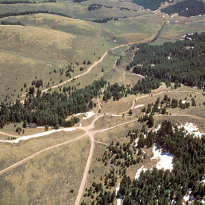
The gravel road winding parallels Trail Creek, which is lined by low willows. It corresponds roughly to the Indian road that Lewis, Drouillard, Shields, and McNeal followed westward from the forks of the Beaverhead River.
Across the Great Divide
Over Lemhi Pass
by Joseph A. Mussulman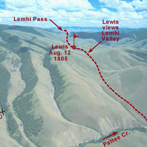
Below the summit of today’s Lemhi Pass, Lewis said that he had reached “the most distant fountain of the waters of the mighty Missouri in surch of which we have spent so many toilsome days and wristless nights.”
Meeting the Shoshones
by Joseph A. Mussulman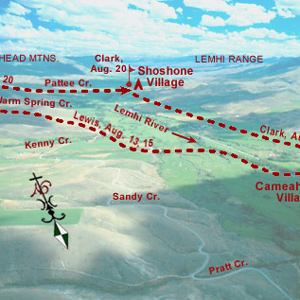
A few more Shoshones came in sight. Making all the benevolent signs and sounds he could think of, pondering ways to bring the wary Indians within talking distance, Lewis finally touched the hand of an elderly woman, and the spark of international friendship was struck.
The Lemhi Valley
Hospitable people
by Joseph A. Mussulman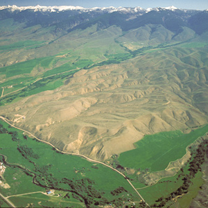
Lewis and his four companions crossed over the dividing ridge on the west side of the upper Missouri River basin and the Columbia drainage, then descended a dusty, well-traveled Indian road for some miles down into a “handsome little valley” among the sources of the Columbia River basin.
The Shoshone Fish Weirs
by Joseph A. Mussulman, Steve F. Russell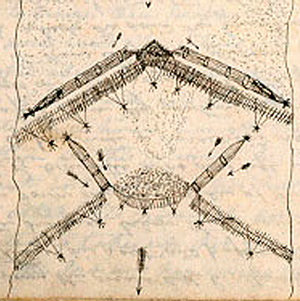
Clark visits a Shoshone camp on the west bank of the Lemhi River near today’s Salmon City, where he and his men are fed on “Sammon boiled, and dried Choke Cher[rie]s,” and taken on a sight-seeing trip to the nearby permanent fishing weirs.
The Salmon River
A river of no return
by Joseph A. Mussulman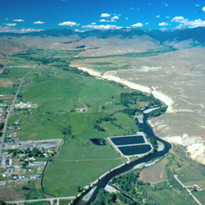
On the 23 August 1805, the centuries-old fantasy of a “water route across the continent for the purposes of commerce” dissolved in the roar of an unimaginable torrent–one of the most dangerous, unforgiving rivers in North America, that would later be called “The River of No Return.”
Leaving the Lemhi Valley
Detour at Tower Creek
by Joseph A. Mussulman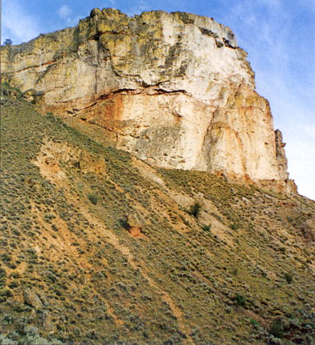
The Salmon winds tortuously through a seven-mile-long canyon where the vertical walls at that time crowded the riverbanks so tightly in several places that Clark and his party were compelled to clamber over “four mountains verry Steap high & rockey.”
The Lost Trail Divide
Leaving the Indian road
by Joseph A. Mussulman
Continuing north up the North Fork Salmon River, they leave a good Indian road and must cut their own trail. Were they lost? Sergeant Gass’s laconic remark gives us a hint: “This was not the creek our guide wished to have come upon.”
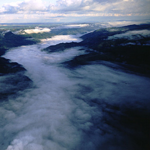
Travelers’ Rest by Air
Turning point
by Joseph A. Mussulman
For three days the Corps rested here, gathering strength for the arduous 150-mile trek across the Bitterroot Mountains. The campsite was about two-thirds down in the photo, among the cottonwoods that shelter Lolo Creek.
Travelers’ Rest
Hub of the west
by Joseph A. Mussulman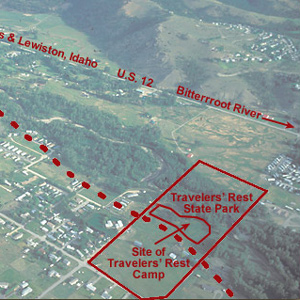
In the afternoon of 9 September 1805 they turned westward at a creek they dubbed Travelers’ Rest, today known as Lolo Creek. They stopped at a gathering place that Indians had been using for that same purpose for thousands of years.
Travelers’ Rest Creek
Today's Lolo Creek in Montana
by Joseph A. Mussulman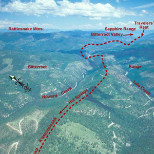
At 3 o’clock in the afternoon, 11 September 1805, Toby led the Corps of Discovery out of Travelers’ Rest camp toward the Bitterroot Mountain barrier.
Lolo Hot Springs
"beautiful to see"
by Joseph A. Mussulman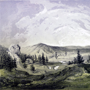
“These Springs are very beautiful to See, and we think them to be as good to bathe in &c. as any other ever yet found in the United States,” avowed Private Joe Whitehouse.
Packer Meadows
"A pretty little plain"
by Joseph A. Mussulman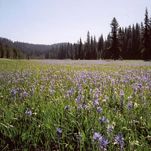
Lewis acknowledged it was “a pretty little plain of about 50 acres plentifully stocked with quawmash” and “one of the principal stages or encampments of the indians”
Climbing Wendover Ridge
Leaving the Lochsa
by Joseph A. Mussulman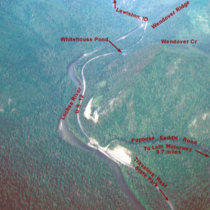
“Several horses Sliped and roled down Steep hills which hurt them verry much The one which Carried my desk & Small trunk Turned over & roled down a mountain for 40 yards & lodged against a tree, broke the Desk…”
Snowbank Camp to Lonesome Cove
Tough going
by Joseph A. Mussulman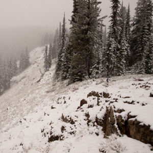
Although none of the journalists mentioned it, the very presence of last winter’s snow on those mountains in late September must have aroused the feeling that crossing the Rockies was going to be even tougher than they had figured.
The Bitterroots by Air
"Tremendious Mountanes"
by Joseph A. Mussulman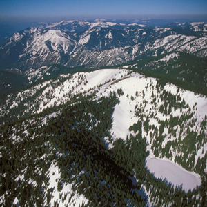
“I have been wet and as cold in every part as I ever was in my life,” Clark complained. “Indeed I was at one time fearfull my feet would freeze in the thin mockersons which I wore.”
A ‘Sinque’ Hole
Below the Smoking Place
by Joseph A. Mussulman
Private Whitehouse reported: “Camped at a Small branch on the mountain near a round deep Sinque hole full of water.”
Hungery Creek
And a return to Bald Mountain
by Joseph A. Mussulman
By the evening of 17 September 1805, their seventh sleep west of Travelers’ Rest, it was obvious to the captains that the Indians’ assurance that they could cross the mountains in six days was false, whereas the prediction that they would find no game there was all too true.
Weippe Prairie by Air
"Tryumph"
by Joseph A. Mussulman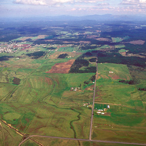
For countless generations, Weippe Prairie (prounouced WEE-yipe), like Travelers’ Rest, was a major node in the transportation, trade, and social networks of the Rocky Mountain West.
Eldorado Creek
Full Stomachs to Pheasant Camp
by Joseph A. Mussulman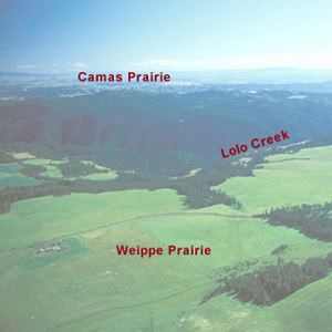
“we killed a few Pheasants, and I killd a prarie woolf [coyote] which together with the ballance of our horse beef and some crawfish which we obtained in the creek enabled us to make one more hearty meal.
Clearwater Canoe Camp by Air
by Joseph A. Mussulman
Still sick and exhausted from their recent crossing of the Bitterroot Mountains, Lewis, Clark, and their crew arrived on 26 September 1805, at what they called Canoe Camp, on the Clearwater River.
Colter’s Creek
Today's Potlatch River
by Joseph A. Mussulman
At 3 p.m. on 7 October 1805, the Corps loaded their five new dugout canoes–four large ones plus a small one “to look ahead”–and set out down the Clearwater River toward the Columbia and the Pacific beyond.
Meeting the Snake
Water color
by Joseph A. Mussulman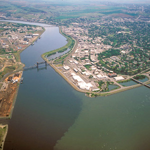
The Corps’ four-day trip to this point from Canoe Camp on the Clearwater in their five crowded dugouts was a taste of things to come.
Tucannon and Palouse Rivers
"rugid rocks"
by Joseph A. Mussulman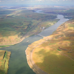
Now they entered a four-mile-long torrent, its climax a “narrows or narrow rapid” through which a channel 25 yards wide was confined between “rugid rocks” for a solid mile and a half.
Snake River Rapids
"Stuk fast"
by Joseph A. Mussulman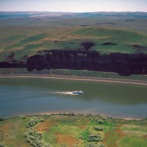
The boating didn’t improve on 14 October 1805. At the head of a particularly bad three-mile-long rapid, three canoes “Stuk fast for some time . . . and one Struk a rock in the worst part.”
Meeting the Columbia
A welcoming fanfare
by Joseph A. Mussulman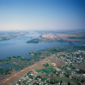
In the afternoon of 16 October 1805, the expedition portaged around “the last bad rapid as the Indians Sign to us”–the last on the Snake River, that is–and soon arrived at the “Great River of the West,” the Columbia.
Columbia River near Blalock
Greatest chief
by Joseph A. Mussulman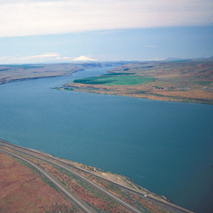
This scene’s most arresting feature is still the “high mountain of emence hight covered with Snow” on the photo’s horizon. Clark mistook it for Mount St. Helens. The Indians called the mountain Pahtoe. Since 1838 it has been known as Mount Adams.
Miller Island
River of the falls
by Joseph A. Mussulman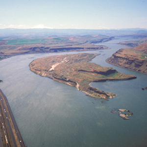
Near the west end of the island, they passed a sizeable tributary local Indians called To war ne hi ooks. The journalists left us no hint that the word they heard as Towarnehiooks was a Chinookan expression meaning “enemies.”
The Dalles
Through the Narrows
by Joseph A. Mussulman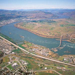
There really was no need for him to have been on the defensive. Pierre Cruzatte cast a spell over the assembled Indians with his fiddle, which was much more effective than any pompous diplomatic talk.
Beacon Rock by Air
Tidewater mark
by Joseph A. Mussulman![]()
On 31 October 1805, Clark first saw this “remarkable high detached rock,” the eroded core of an ancient volcano, which he estimated stood eight hundred feet above the riverbank and was four hundred yards in circumference.
Columbia River Dams
The rough places plain
by Joseph A. Mussulman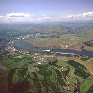
Bonneville Dam, was the first dam to be built on the Columbia River. The slackwater pool it impounds, called Lake Bonneville, eliminated the Cascades as a barrier to commercial shipping, and provided a deep, navigable channel for barges and tugs.
Ridgefield National Wildlife Refuge
Horrid noise
by Joseph A. Mussulman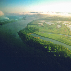
On the night of 4 November 1805 the expedition camped near a pond now called Post Office Lake. The next morning a weary, groggy Clark complained that he “could not Sleep for the noise” made by the numerous waterfowl.
The Columbia River Estuary
"Great joy"
by Joseph A. Mussulman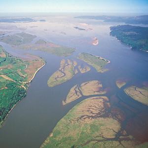
When the sky cleared briefly at about noon on 7 November 1805, a rising cheer may have startled the myriad waterfowl in the area, for Clark wrote, “we are in view of the opening of the Ocian, which Creates great joy.”
Point Ellice
"blustering point"
by Joseph A. Mussulman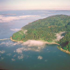
It was “the most disagreeable time I have experienced,” Clark grumbled on 15 November 1805. “Confined on a tempiest Coast wet, where I can neither get out to hunt, return to a better Situation, or proceed on”
Cape Disappointment
"This Emence Ocian"
by Joseph A. Mussulman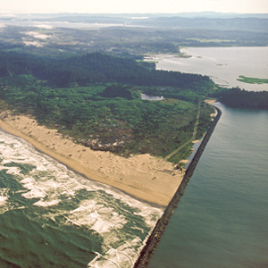
Private Whitehouse thought his captains had named Cape Disappointment “on account of not finding Vessells there,” but it had received the name years earlier.
Long Beach
Mementos
by Joseph A. Mussulman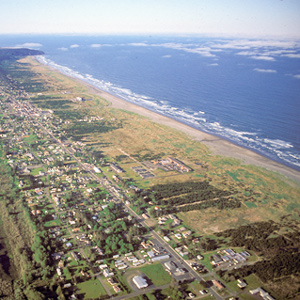
Clark’s party continued north along the beach for four miles, to the vicinity of today’s Long Beach, Washington. Here Clark memorialized their first visit to the Pacific Ocean by marking his name and the date on a small pine tree.
The Lewis and Clark River
Coast Range winter
by Joseph A. Mussulman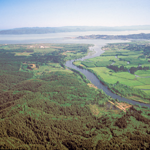
During their time at the coast, the Corps saw only six sunny days; the rest brought clouds, fog, rain, and a little snow. Fifty-three were partly clear. That’s a normal winter on the west slopes of the Coast Range.
The Salt Works by Air
Seaside, Oregon
by Joseph A. Mussulman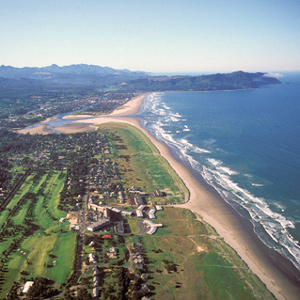
Here they built an oven of stones and, day and night for a month and a half, scooped perhaps 1,400 gallons of water from the surf, boiling it down to about twenty-eight gallons of salt.
Over Tillamook Head
Clark's point of view
by Joseph A. Mussulman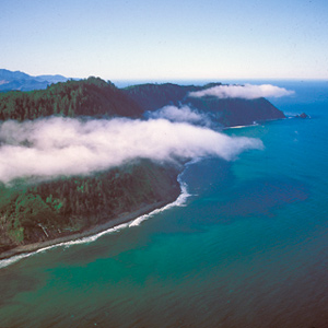
After passing the salt works and continuing along the “round Slippery Stones under a high hill,” Clark related, “my guide made a Sudin halt, pointed to the top of the mountain and uttered the word Pe Shack which means bad, and made Signs that we . . . must pass over that mountain.
Ecola
Whale tale
by Joseph A. Mussulman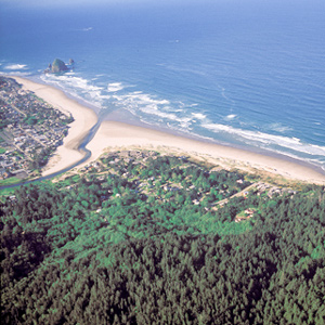
By the time Clark and his party got to present-day Cannon Beach, Oregon, on 8 January 1806, the locals had picked the dead whale’s 105-foot-long carcass clean.
Long Camp Observations
25 May–9 June 1806
by Robert N. Bergantino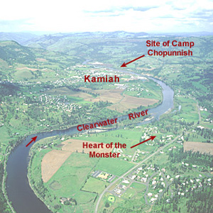
An analysis of Lewis’s celestial observations made during their stay at Long Camp near present-day Kamiah, Idaho.
The Salmon and Snake Villages
Side trip
by Joseph A. Mussulman
When the captains saw Nez Perces with several fresh chinook salmon, “fat and fine,” which the Indians said came from “Lewis’s River,” known today as the Salmon River, they dispatched Sgt. John Ordway and two privates to buy some.
Ordway’s Fishing Trip
No mere half day
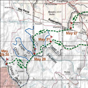
On 27 May 1806, Sergeant John Ordway, accompanied by Privates Frazer and Weiser, left Long Camp under orders to ride over to “the East branch of the Salmon River. The spring run of chinooks had not yet appeared on the Clearwater, so the three were to buy some fresh fish.
Rocky Point Views
One last view
They crossed over the peak without pausing for one last view of “those tremendious mountanes . . . in passing of which,” Clark would assert two days later, “we have experienced Cold and hunger of which I shall ever remember.”
Passing Hell’s Gate
Up the Blackfoot River
by Joseph A. Mussulman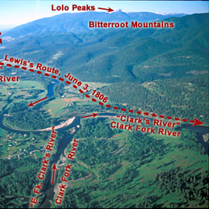
The continuation of the Northern Nez Perce Trail led from their camp at Travelers’ Rest to the plains near the Great Falls of the Missouri, saving hundreds of miles from the expedition’s 1805 route.
Seaman’s Creek
Clues to his name
by Joseph A. Mussulman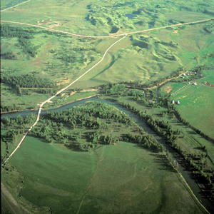
Twenty-eight and one-half miles upriver from their camp of 4 July 1806 the Indian road crossed a stream Lewis named after William Werner. At mile 31, they camped near the mouth of a stream the captain named after his dog, Seaman.
The Blackfoot River by Air
Prairie of the knobs
by Joseph A. Mussulman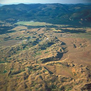
On 6 July 1806, Lewis’s eleven-man party had broken camp at the mouth of a Blackfoot River tributary they named Seamans Creek, after, and headed on up the river along the “road” that Indians living in the Rocky Mountains called the Cokahlahrishkit—the Road to the Buffalo.
Lewis and Clark Pass by Air
Dividing ridge
by Joseph A. Mussulman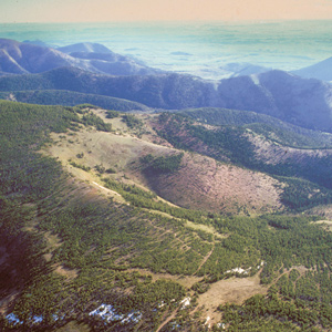
Lewis and Clark Pass is six miles north of Rogers Pass, where Montana Highway 200 crosses the Continental Divide. The concept of the continental divide, and the term itself, would emerge only after another fifty years of western exploration.
Lewis and Clark Pass
A shorter way
by Joseph A. Mussulman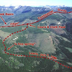
Sergeant Gass recorded that on 7 July 1806, Lewis’s detachment took a three-hour lunch break and then proceeded four miles, “when we came to the dividing ridge between the waters of the Missouri and Columbia.”
The Dearborn River Crossing
Along the Old North Trail
by Joseph A. Mussulman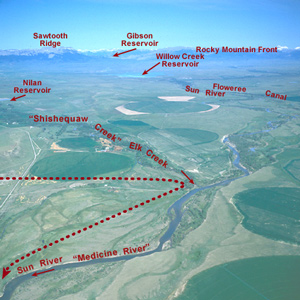
Shortly after crossing the Dearborn River, Lewis saw that the Indian road “continued along the foot of the mountain to the West of north” so he and his men cut northeast across the “tolerably level” plain toward the Sun River.
Down the Sun River
Through the "Battle Hills"
Meriwether Lewis has tempted fate and his “chapter of accidents” again by re-entering the domain of the people he had repeatedly been advised to steer clear of—the Blackfeet, Siksikas, Atsinas, and Assiniboines.
Return to the Portage
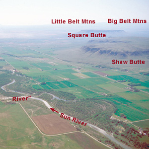
Lewis's hiatus
by Joseph A. Mussulman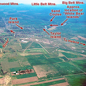
One can almost feel the thrill of wakening to a clear early-summer dawn at this powerful place on the pregnant plains where the Medicine meets the Missouri. Here began a five-day hiatus in Lewis’s master plan for his junket to find the boundary of British-held Canada.
Bozeman Pass
Of great service
by Joseph A. Mussulman
Clark reported, “the indian woman who has been of great Service to me as a pilot through this Country recommends a gap in the mountain more South which I shall cross.” This was one of the few times Sacagawea acted as the guide.
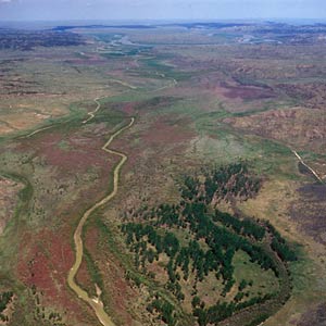
Yellowstone Canoe Camp
by Joseph A. Mussulman
One week and a hundred miles after starting down the Yellowstone River, Clark finally found cottonwood trees large enough for building canoes. That night some Indians made off with half their horses.
Yellowstone Canoe Camp by Air
Horse thieves
by Joseph A. Mussulman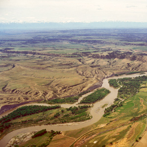
Clark’s party made camp at today’s Park City, Montana, and settled in to build the new canoes and attend to other business. While a few of the men took turns with the three axes they had along, some of the rest, being nearly naked, made elk- and deer-skin clothing.
Camp Disappointment
The northernmost extent
by Joseph A. Mussulman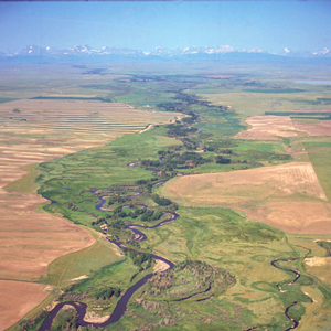
In 1806, Lewis, Drouillard, Joe Field, and Reubin Field made a second excursion up the Marias, this time on horseback. The four men reached the northernmost point of the Expedition’s exploration on 22 July 1806, camping on the south side of today’s Cut Bank Creek.
Pryor Creek
Ill-fated mission
by Joseph A. Mussulman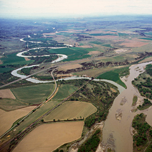
The stream Clark named for Nathaniel Pryor meanders from its montane sources in the mountain range that now bears Pryor’s name to join the Yellowstone River in the area where Pryor began his ill-fated diplomatic mission.
Pompeys Pillar
Pompy's Tower
by Joseph A. Mussulman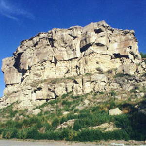
On 25 July 1806, Clark and his contingent of nine men, plus York, Toussaint Charbonneau, Sacagawea, and little Jean Baptiste, arrived at “a remarkable rock Situated in an extensive bottom, on the Star[boar]d. [south] Side of the river.”
Apsáalooke Country
by Joseph A. Mussulman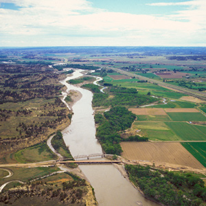
The Crow People called themselves Apsáalooke, sometimes heard as Absarokas or Absalookas, or “Children of the Large-beaked Bird.” Various early white travelers transcribed or defined the name differently, but the Apsáalooke maintain it refers to the raven. One of the oldest and most famous landmarks on Lewis and Clark’s route, now known officially, but erroneously, as Pompeys Pillar or, among the Apsáalooke, Iish-biia ah-naac’he’.
Fight on the Two Medicine
An "accedental interview"
by Joseph A. Mussulman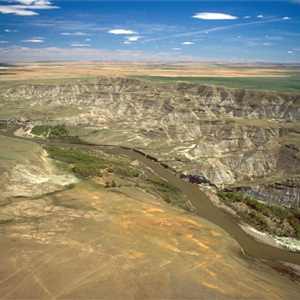
The Indians invited the Americans to share a campsite that night. At daybreak, despite the soldiers’ watchfulness, the Indians tried to steal the Americans’ guns and horses. That immediately erupted into a skirmish.
The Lower Yellowstone
A promising location
by Joseph A. Mussulman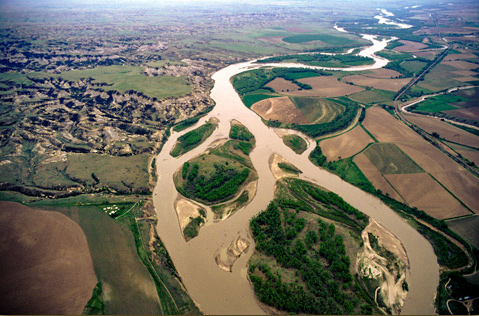
On 30 July 1806 Clark and his party camped near the mouth of the War har sah, or Powder River. He summarized the Yellowstone’s attractions, directing most of his attention toward opportunities for immediate expansion of the fur trade.
St. Louis by Air
The western gate
by Joseph A. Mussulman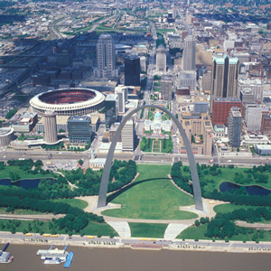
The expedition arrived on 7 December 1803, witnessed the transfer of Louisiana from Spain to the United States, and metaphorically passed through its western gate on 14 May 1804. They would not return until 23 September 1806.
Bighorn Sheep Encounters
by Joseph A. Mussulman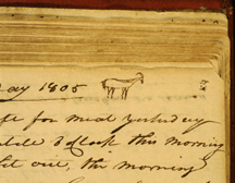
During a reconnaissance assignment eight miles up the Yellowstone River on 26 April 1805, Joseph Field became the first member of the Corps to glimpse a live bighorn sheep.
Experience the Lewis and Clark Trail
The Lewis and Clark Trail Experience—our sister site at lewisandclark.travel—connects the world to people and places on the Lewis and Clark Trail.
![]()
Discover More
- The Lewis and Clark Expedition: Day by Day by Gary E. Moulton (University of Nebraska Press, 2018). The story in prose, 14 May 1804–23 September 1806.
- The Lewis and Clark Journals: An American Epic of Discovery (abridged) by Gary E. Moulton (University of Nebraska Press, 2003). Selected journal excerpts, 14 May 1804–23 September 1806.
- The Lewis and Clark Journals. by Gary E. Moulton (University of Nebraska Press, 1983–2001). The complete story in 13 volumes.
This site is provided as a public service by the
![]()
Lewis and Clark Trail Alliance
with additional funding from the following:

