Figure 1
“Fort Mountain” (present Square Butte)
Southwest of Great Falls, Montana
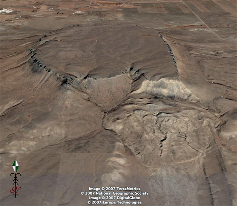
© 2007 Google™.
A few days after embarking from their portage camp at the upper end of the Great Falls of the Missouri in early July 1805, an unusual profile on the western horizon drew the explorers’ attention. On the fifteenth, Meriwether Lewis described it as best he could from the most convenient vantage point he could find.
This mountain has a singular appearance. it is situated in a level plain, it’s sides stand nearly at right angles with each other and are each about a mile in extent. these are formed of a yellow clay only without the mixture of rock or stone of any size and rise perpendicularly to the hight of 300 feet. the top appears to be a level plain and from the eminence on which I was yesterday I could see that it was covered with a similar cost of grass with the plain on which it stands. the surface appears also to possess a tolerable fertile mole [mold] of 2 feet thick, and is to all appearance inaccessible. from it’s figure we gave it the name of fort mountain.
Lewis’s Spyglass
Figure 2a
The Carey Telescope
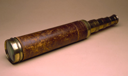
Photo by David Schultz © 1998 Missouri Historical Society.
Figure 2b
The Lincoln Telescope
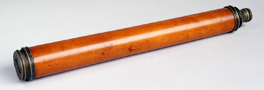
The Atheaeum of Philadelphia.
Lewis may have carried either of two period telescopes that are still in existence. One was built in London, England, about 1800 by William Cary (1759-1825). It consists of an achromatic objective lens that magnifies a field of one arc degree 36 times at 1,000 yards, which would have enabled him to view approximately one-third of “fort mountain” with it at one time. With the five brass drawtubes plus an eyepiece tube (with which focus could be adjusted by sliding it in or out) collapsed into the outer, leather-covered mahogany one, it is 15 inches long and 3¼ inches in diameter. It measures 55¼ inches when extended for use, and therefore was once fitted with a bracket that would enable mounting on a tripod for steadiness. It now belongs to the Missouri Historical Society, a gift of Meriwether Lewis Anderson in 1936.[1]Carolyn Gilman, “The Forensic Conservator and the Science of Lewis and Clark,” Gateway-Heritage, Vol. 20, No. 3 (Winter 1999-2000), 52-57.
The telescope was made about 1790 by Charles Lincoln (c. 1744-1807), also of London. Like Cary’s, it is a refracting terrestrial telescope with a two-element achromatic lens, and therefore was useable only in daylight.[2]The second lens, which righted the inverted image from the front (objective) lens, absorbed so much light that the instrument was unsuitable for viewing the night sky. Thus Lewis explained, when … Continue reading The rest of its optical characteristics have not been determined. It was given to the Athenaeum of Philadelphia in 1976 by Milton Hammer, who had purchased it from a descendant of Lawrence Lewis Sr., of the Lewis family.
Fertile Mold
That “fertile mold of 2 feet thick”—mold was an 18th century word for topsoil or “fine earth”—which despite the distance was near enough to the truth to indicate that he was studying “fort mountain” through his telescope. His comparison of the grass on top with the ground cover on the adjacent prairie would probably have been correct, but that was irrelevant. Owing to the earth’s curvature, from 13 miles away he could see only the upper 970 feet or so. The lower 130 feet of the out-slope as well as the prairie at its base were hidden beyond his horizon.
His observations weren’t precisely correct—it is indeed made of stone, not clay—but he got the gist of the picture, and considering the fact that he was 13 miles away from it, not ten, as he had estimated (the clear mountain air had fooled him again), he did pretty well.
He didn’t know enough about the still-nascent science of geology to make sense of any more details, such as its numerous thin stratas of volcanic rock, even if he could have made them out.[3]John C. Green, American Science in the Age of Jefferson (Ames: Iowa State University Press, 1984), 242-52. Americans such as Amos Eaton (1746-1822) and the “father of American geology,” … Continue reading Moreover, words such as laccolith and most of the rest of the vocabulary used to describe it today weren’t yet in common scientific use in the U.S.
Geologic History
The history of the “mountain” Lewis saw began more than a billion years ago, when two continental plates had a geologic fender-bender along a line now known as the Great Falls Tectonic Zone. Much later—perhaps only 75 million years ago, in the latter part of the Cretaceous period—pasty magma at the earth’s core burst through a particularly weak spot in the older volcanic rocks of the Two Medicine Formation, in the vicinity of Twin Sisters peaks, about two miles southeast of the Missouri River’s present channel, and midway between Hardy and Craig, Montana. The eruptions continued for several million years, flinging cinders, ash and fragments of rock thoughout an area roughly 80 square miles in extent. The result was what is now called the Adel Volcanics or, loosely speaking, the Adel Mountains.[4]David Alt and Donald W. Hyndman, Northwest Exposures: A Geologic Story of the Northwest (Missoula, Montana: Mountain Press, 1995), 199-202. As the Corps of Discovery worked its way up the Missouri between the volcanic debris that often loomed hundreds of feet above their heads, the Adel Volcanics were, as Sergeant Gass remarked in his journal entry for 17 July 1805, “a very desert looking part of the country.”
Meanwhile, great volumes of lava oozed through narrow subsurface fissures in the older volcanic rocks in all directions throughout the immediate vicinity. Each of those many pipelines squirted their contents into weak spots, earthen receptacles somewhat like cisterns. During rhythmic pauses in the lava flow, each layer cooled and hardened into a dark rock that geologists for the past century or so have called shonkinite.[5]The name shonkinite, a granular plutonic rock related to syenite, was first proposed in 1895; the term syenite, however, dates from 1796, although neither Lewis nor Clark ever invoked it. In 1804 the … Continue reading Each successive injection of lava seared the cooler layer beneath it. The lava filled each cistern layer upon layer, eventually raising a bubble or blister above the surrounding crust of the earth.
The Greek word for cistern is lacco; the Greek word for rock is litho. This particular blister—the “lacco-lith” Lewis and Clark dubbed “fort mountain”—this cistern-full of cold hard shonkinite, stands roughly 24 miles north, and a little to the east, of the site of the mighty volcano that fed it. When the volcano expired, the lava that was left in the fissure cooled and hardened too, and became what is called a dike. (A well known example of such a dike, part of a different volcanic system than this one, is the Great Wall that captured Lewis’s interest as he passed through the White Cliffs of the Missouri.)
Just when and how Lewis and Clark’s “fort mountain” came to be called Square Butte is uncertain. North American explorers before Lewis and Clark, such as Peter Fidler or John Evans, had learned that Indians called these landmarks “Battle Hills,” perhaps for the same reason that Lewis chose “Fort Mountain.” Or perhaps the Indians actually called these three laccoliths “Rattle Hills” because at least this one looked a little like an Indian rattle.
Lewis’s observation that “it’s sides stand nearly at right angles with each other and are each about a mile in extent” became, in Nicholas Biddle‘s 1814 edition of the journals, “forms nearly a square.” That might have suggested the alternative name, Square Butte, but there is no evidence that it did. Indeed, in the early 1850s Isaac Stevens identified the westernmost elevation by its present name, but reverted to Indian precedent for the other two: “We continued up in the direction of the pass [Cadotte’s Pass] between the Crown Butte and the Rattlers, prominent landmarks west of the Sun River, and visible at a great distance.”[6]Reports of explorations and surveys, to ascertain the most practicable and economical route for a railroad from the Mississippi River to the Pacific Ocean, 12 vols. in 13 (Washington, D.C.: A..P. … Continue reading One may suppose that the name “Rattlers” came from the presence of rattlesnakes hereabouts, but that is hardly a distinctive attraction in this particular neighborhood.
Becoming a Butte
Neither Lewis nor Clark considered calling “fort mountain” a butte, which their French guides and engagés could have told them was an Old French word meaning “landmark,” or “target,” or even a backstop for a target. In the same language its definition later evolved into “rising ground; knoll, mound, or hillock.” One of the foregoing may have been the sense in which the journalists meant it on the two sole occasions when they used it. On 28 July 1804 Whitehouse wrote, “we Came to a hi CLift or Buut one hun[dred] feet,” and Lewis, in the list of mineralogical specimens he sent back from Fort Mandan in the spring of 1805, noted that one of the items was “Found just above the entrance of the cannon Ball river,” where “the butt[e] is principally composed of this sand.”[7]Moulton, Journals, 3:473. Eventually, the word found its own place in the regional jargon of the American West.
For example, the explorer John Charles Frémont, who made five trips through the West, wrote: “The French word butte . . . is naturalized in the region of the Rocky Mountains; and, even if desirable to render it in English, I know of no word which would be its precise equivalent. It is applied to the detached hills and ridges which rise abruptly, and reach too high to be called hills or ridges, and not high enough to be called mountains.” He explained that knob was a Westerner’s more descriptive term, and the Spanish cerro was nearly synonymous, but “no translation, or paraphrase, would preserve the identity of these picturesque landmarks, familiar to the travelers, and often seen at a great distance.”[8]John Charles Frémont (1813-1890), Report of the Exploring Expedition to the Rocky Mountains in the Year 1842: and to Oregon and North California in the years 1843-44 (Washington: Blair and Rives, … Continue reading
Twenty years later it was still an unruly noun. An essayist in the Century Illustrated Monthly Magazine wrote—rolling his eyes between the parentheses—”(Everything in the way of hill, rock, mountain, or clay-heap is called a butte in Montana.)”[9]E. V. Smalley, “The New North-West,” Century Illustrated Monthly Magazine, Vol. 24, No. 10 (October 1882), 510. See also Alan H. Hartley, Lewis & Clark Lexicon of Discovery (Pullman: … Continue reading It was not to be found in American dictionaries until 1906, when A Thesaurus Dictionary of the English Language indifferently defined it as a “conspicuous hill or low mountain range.” Even in 1868, when some miners on the western slope of the Continental Divide out in Montana Territory named their new settlement after a pyramidal rhyolite landmark called Big Butte, it was used in the Old French sense.
By the end of the 20th century, however, lexicographers had settled on a more precise definition of the word. Encyclopedia Britannica Online defines it as “a flat-topped hill surrounded by a steep escarpment from the bottom of which a slope descends to the plain.” The American Heritage Dictionary (Fourth Edition, 2000) says it’s “a hill that rises abruptly from the surrounding area and has sloping sides and a flat top.”
Today there are more than 2,000 geologic features in the U.S. officially known as buttes. Only a dozen or so are east of the eastern boundaries of the Dakotas, Nebraska, Kansas, and Texas, and none of them fit the most recent definition of the term. A random sampling of a few of the rest brings up none that are quite as symmetrical as this particular Square Butte. There are eleven Square Buttes in Montana alone, among which this is the only one that meets the current lexical requirements. Indeed, this may be the one-and-only classic example of a laccolith that is really a butte in the 21st-century sense of the word. In this instance, leaving aside all those hundreds of lumps, bumps, and pyramids that benighted generations burdened with the arbitrary old noun, the dictionary has at last come to terms with geology.
Aerial Photo Gallery
Google Earth is extremely useful for its potential benefits to our understanding and appreciation of the globe’s topography, but to fully appreciate a geological phenomenon as unique and instructive as Square Butte, we ought to see it up close—through a photographer’s eye. Thanks to local rancher Bob Rumney and his camera (a digital Canon AE520) and the convenience of his powered parachute (above), we are able to observe details that Captain Lewis probably couldn’t make out, even with his spyglass.
Figure 3
Aerial Photographer Bob Rumney
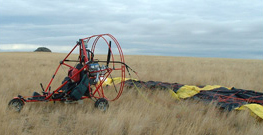
© 2003 Robert G. Rumney.
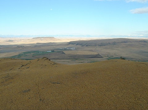
Looking west from above the east rim of Square Butte, one sees two more laccoliths created during the late Cretacious period as bubbles of shonkinite that flowed through separate cracks or faults near the surface. The closer one, slightly north of west in the shadow of a cloud, is 3.25 miles from Square Butte. At approximately 9.5 square miles, it is more than four times the size of Square Butte, and is only 100 feet lower. Since the latter part of the 19th century it has been called Shaw Butte, from its proximity to the frontier military post called Fort Shaw, established in 1867. It has also been called, unofficially, Round Butte, from the curvilinear profiles it displays when viewed from any aspect at ground level. Its roundness signifies that it is younger than either Square Butte or Crown Butte, and that the sedimentary overburden is still eroding.
Crown Butte, which is 8 miles due west of Square Butte, is trimmed on its east face with serrated cliffs rising approximately 900 feet above the surrounding prairie. Its east rim is only 26 feet lower than Square Butte, while its west side slopes down to the prairie, making it resemble a giant diadem tilted back on a subterranean royal head. In Montana alone there are six other summits called Crown Butte, but none is as stylish as this one. Since 1982 Crown Butte has been owned by The Nature Conservancy, which manages it as a nature and wildlife Preserve and protects its native grassland ecosystem.
Figure 4
View west-by-north from “fort mountain”
The snow-crested Rocky Mountain Front is faintly
visible on the far horizon.
© 2003 Robert G. Rumney.
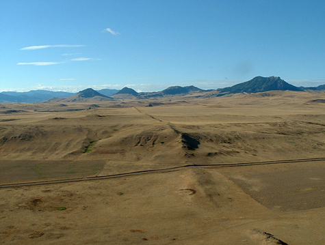
The faint sharp ridge through the center of the photo is the upper edge of the subsurface conduit through which, some 74 million years ago, magma flowed from its volcanic source 25 miles away to the blister Lewis dubbed “fort mountain.” In the Google Earth image at the top of this page, the dike is seen entering the laccolith as two parallel ridges in the southeast (lower right) corner. The straight line that cuts through the dike is a county road. The two conical volcanic extrusions at left of center are themselves the terminals of other fissures through which magma once flowed. The one farthest left is called Antelope Mountain; the next one to the right is Finigan Mountain.
Figure 5
View from above the southeast rim of Square Butte
© 2003 Robert G. Rumney
Lewis’s perception that the top of “fort mountain” was flat was acceptable, considering how far away he was from it. He didn’t mention, because he undoubtedly couldn’t tell, that it is tilted a little; the north end is about 200 feet higher than the south end. Even though he was not close enough to compare the grasses on the prairie with those on top, they probably were identical. Since then, agriculture and other impacts of civilization have greatly changed the vegetation on the prairie, and cattle grazing on the butte may have somewhat modified that grass also.
Figure 6
View northeast from above the southeast corner.
© 2003 Robert G. Rumney.
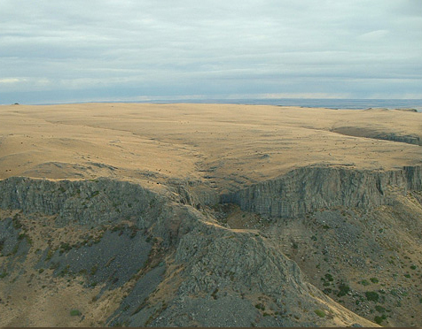
Some two thousand feet of sedimentary rock consisting of mud, sand and shells covered the site where this laccolith arose. Over millions of years most of that overburden eroded away, revealing the old blister of hard, resistant shonkinite barely covered with a thin “fertile mold” of sandy soil, and nearly exposing the uppermost edge of the dike that once fed it. The still-ongoing processes of erosion are most evident at the south end of the butte. A private jeep trail leads up one of these steep draws to the top, in some places scarcely wider than a fat cow.
Figure 7
View northeast across the south end
© 2003 Robert G. Rumney.
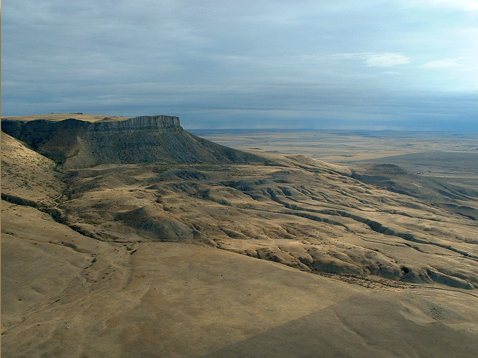
The serrated upper margin of the east face of this laccolith is the view Lewis had from his location on 14 July 1805. From thirteen miles east they easily resembled impregnable battlements, which justify the name he gave to the whole butte. One wonders whether a recollection of the famous M. Blanchard and his balloon (see Blanchard’s Balloon) crossed Lewis’s mind at that moment. In any case, he didn’t mention it in his journal for the day.
Figure 8
View South, above the Serrated East Rim
On the horizon are the Big Belt and the Crazy Mountains
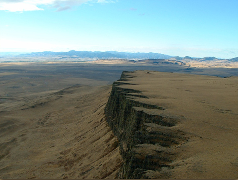
© 2003 Robert G. Rumney.
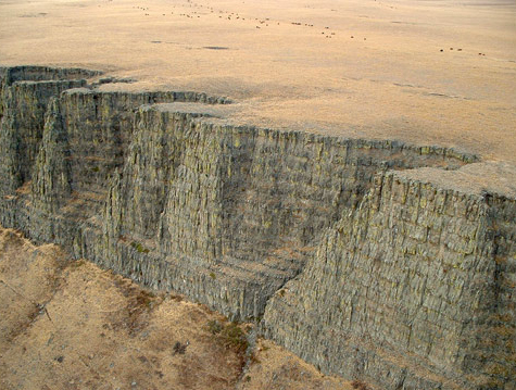
Many layers of shonkinite, each from 14 to 16 feet thick, are separated by discolorations created when each surge of hot magma thermally metamorphosed the cooler layer that preceded it. The conspicuous parallel vertical lines in each layer are evidence of the columnar jointing that is typical of volcanic rocks, which fracture into tall prisms of often hexagonal polygons as they cool. The other two laccoliths in this group, plus Cascade Butte, which is eight miles south of Square Butte, are similarly layered and columnar jointed shonkinite.
Faintly visible, a widely scattered herd of domestic cattle grazes near the middle of the butte. It is seasonally driven up and down via a jeep trail on the south end of the butte (Fig. 7). The rancher has installed a tank near the east rim, to which water is pumped from a well in the Sun River valley.
Figure 9
Shonkite Strata
© 2003 Robert G. Rumney.


Square Butte is a High Potential Historic Site along the Lewis and Clark National Historic Trail managed by the U.S. National Park Service. The site is privately owned but can be seen for several miles around Great Falls, MT.—ed.
Notes
| ↑1 | Carolyn Gilman, “The Forensic Conservator and the Science of Lewis and Clark,” Gateway-Heritage, Vol. 20, No. 3 (Winter 1999-2000), 52-57. |
|---|---|
| ↑2 | The second lens, which righted the inverted image from the front (objective) lens, absorbed so much light that the instrument was unsuitable for viewing the night sky. Thus Lewis explained, when making observations of the lunar eclipse on 14 January 1805, “I had no other glass to assist me in this observation but a small refracting telescope belonging to my sextant, which however was of considerable service.” |
| ↑3 | John C. Green, American Science in the Age of Jefferson (Ames: Iowa State University Press, 1984), 242-52. Americans such as Amos Eaton (1746-1822) and the “father of American geology,” William Maclure (1763-1840), were at the cutting edge of the new science. The emergence of the concept of stratigraphy, for example, which had originated as a product of the study of fossils, was yet to coalesce into the term itself—which occurred about 1865. Martin J. S. Rudwick, Bursting the Limits of Time: the Reconstruction of Geohistory in the Age of Revolution (Chicago: University of Chicago Press, 2005), 215, 534-36. Lewis did much better in the field of botany, which was then farther along than geology among the disciplines of the natural sciences. |
| ↑4 | David Alt and Donald W. Hyndman, Northwest Exposures: A Geologic Story of the Northwest (Missoula, Montana: Mountain Press, 1995), 199-202. |
| ↑5 | The name shonkinite, a granular plutonic rock related to syenite, was first proposed in 1895; the term syenite, however, dates from 1796, although neither Lewis nor Clark ever invoked it. In 1804 the early English geologist Gregory Watt was among the first to posit a theory of columnar jointing. |
| ↑6 | Reports of explorations and surveys, to ascertain the most practicable and economical route for a railroad from the Mississippi River to the Pacific Ocean, 12 vols. in 13 (Washington, D.C.: A..P. Nicholson, 1855-1860), vol. 12, part 2: 118-19. |
| ↑7 | Moulton, Journals, 3:473. |
| ↑8 | John Charles Frémont (1813-1890), Report of the Exploring Expedition to the Rocky Mountains in the Year 1842: and to Oregon and North California in the years 1843-44 (Washington: Blair and Rives, Printers, 1845), 161. |
| ↑9 | E. V. Smalley, “The New North-West,” Century Illustrated Monthly Magazine, Vol. 24, No. 10 (October 1882), 510. See also Alan H. Hartley, Lewis & Clark Lexicon of Discovery (Pullman: Washington State University Press, 2004), 30-31. |