Names, once they are in common use, quickly become mere sounds,
their etymology being buried, like so many of the earth’s marvels,
beneath the dust of habit.
Stevens’ 1854 Map
Map showing the Indian tribes in Washington territory and on the Missouri and its tributaries to the mouth of the Yellowstone
Detail, 1854
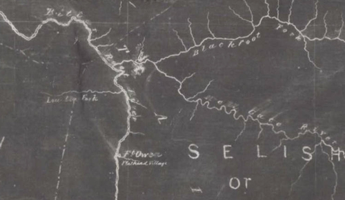
Mansfield Library, University of Montana, Missoula.
On this map, the creek is labeled “Lou Lou Fork,” one of several spellings on maps of the nineteenth century.
After John Mullan‘s map, the next appearance in print of any name at all for the Travellers-rest Creek of Lewis and Clark was in 1854, on a map by Isaac Stevens where it was labeled the “Lou Lou Fork” of the “Bitter Root River.”[1]Isaac Ingalls Stevens (1818-1862), “Map showing the Indian tribes in Washington Territory and on the Missouri and its tributaries to the mouth of the Yellowstone” (Washington, D.C.: U.S. … Continue reading Subsequently, notwithstanding Lt. Mullan’s consistent spelling of the name as “Lo-Lo” in his own field notes, it was spelled “Lou-Lou” throughout Stevens’s final published reports on the Pacific railroad surveys. That spelling may have been Stevens’s personal preference, one small bit of evidence of his titular authorship and command. Unfortunately, it raised the question of pronunciation, which in turn introduced confusion as to the name’s etymology—how to explain the connection between “Lolo” and “Loo-Loo”?
The spelling o-u can represent four different sounds, as in 1) loud, 2) country, 3) you, and 4) pour. The “ow” and “uh” sounds of the first two do not fit well into the four-letter, two-syllable name, so they can be dismissed. Stevens may have heard it pronounced with a long o, the way Thompson, Ashley and Mullan apparently heard it, and Stevens may have chosen to spell it, idiosyncratically, o-u as in pour. Then as now, however, “Lou” was a common nickname for Louis and Louise, so it was natural to read it as “Loo-Loo.”
Perhaps it was just a technical slip-up. Until the end of the 19th century the setting of cold cast-metal type was done by hand, one character at a time picked up with a composing stick from the appropriate compartments in a distribution box. Speed was basic to the professional typesetter’s skill, but errors occasionally resulted from a misreading of manuscript copy, or misunderstanding of a spoken word. Thus it is conceivable that “Lou-Lou” was merely a typesetter’s error, and the misprint was either overlooked or ignored in the rush to get the monumental work (12 volumes in 13) off the presses, bound, and out the door.
There might be one other plausible guess as to the origin of Lou-Lou as a synonym for Lolo. Perhaps Stevens heard a local person, someone in whom he instinctively placed his respect and confidence on grounds of seniority, reputation, or experience, correct a third party’s pronunciation from Lolo to Loo-loo. Given, then, a name as unusual as Lolo, it was easy for even the Ciceronian Isaac Stevens to be convinced of a preferred interpretation by an honest man. So the Governor transcribed the unfamiliar version as Lou-Lou, which sounded a bit classier than the crude Loo-Loo.
Whatever the explanation was, the spelling “Lou-Lou” implicitly bore the sanction of the brilliant but imperious Isaac Stevens. Cartographers may have bowed to the governor’s authority and repeated his orthography, map after map, year after year, until it firmly established itself as a cartographic convention. It wouldn’t have mattered so much if the pronunciation rhyming with “you-you” hadn’t evoked so many other explanations (see Lolo Stories). Nevertheless, the spellings Lo-Lo, Lolo, Lou-Lou and Loo-Loo co-existed often on the same map (see the General Land Office map on this page)—from the early 1850s until the end of the century, tending to obscure the source and meaning of the real name.
DeLacy’s Gold Rush Trails
W. W. deLacy’s map of the Territory of Montana
To see the trails and labels, point to the map.
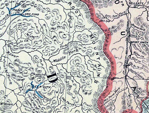
Archives and Special Collections, Maureen and Mike Mansfield Library, The University of Montana, Missoula
Early in October 1860, a party of 12 prospectors recruited at Fort Walla Walla by an ambitious Irish immigrant, Elias D. Pierce (1824-1897), boldly defied laws of Washington Territory and a treaty with the Nez Perce Tribe, and snuck into the Reservation as far as Oro Fino Creek, where they struck pay dirt within a few days.[2]Ed Pierce had been in the region a long time, by contemporary standards. He spent the winter of 1852 camped on the site of Lewis and Clark’s 1805 “Canoe Camp” while he tried to drum … Continue reading The word got out, and within 9 months the new gold field was jammed with thousands of gold seekers. The “good diggin’s” were soon claimed, so most of the hopefuls took up their picks and pans and spread out through the mountains. Within months, “cities” like Pierce City, Oro Fino, and Elk City sprang to life.
Within another 12 months, out-of-luck and out-of-work prospectors were beckoned eastward across the Bitterroot Mountains by late-breaking news of a rich strike, dated July 28, 1862, on Willard’s Creek in Montana Territory. The race was on, and the courses were obvious: either the Northern Nez Perce Trail and the “Lou-lou Fork,” or the Southern Nez Perce Trail and the “Nez Perce Fork.” There wasn’t a moment to waste figuring out which was the faster. Just choose one and go for it. No other name for either trail was necessary. Those men were in a hurry, and it was, each man hoped, a one-time thing. The roads beyond the two Nez Perce trails’ eastern termini were equally clear. Another year, another boom, and Idaho Territory’s (now Montana’s) Virginia City was in the headlines. And those were only the beginnings.
The full title of this map is: “Copy of W. W. deLacy’s map of the Territory of Montana with portions of the adjoining territories showing the gulch or placer diggings actually worked and districts where quartz (gold & silver) lodes have been discovered to January 1st 1865.” That explains the blue lines that the copyist inserted by hand to highlight the gold fields at Pierce City and Elk City.
Lou-Lou, Loo-Lo, or Lo Lo?
Diagrams of the valley of the Bitter Root River, above the mouth of Loo-Lo Fork, Montana, showing all the public surveys made therein.
General Land Office map
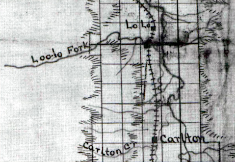
Archives and Special Collections, Maureen and Mike Mansfield Library, The University of Montana, Missoula
The question was still open in 1894, when it was partially resolved—or avoided—with an apparent compromise in this manuscript map that was drawn at the General Land Office in Washington, D.C., Titled “Diagrams of the valley of the Bitter Root River, above the mouth of Loo-Lo Fork, Montana, showing all the public surveys made therein.” Its purpose was to update the progress record of the general survey of public lands that the Territorial Legislature had authorized in 1867.[3]Resource Identifier, umt040093. The Legislature’s action conformed with the rectangular survey objectives and procedures that were defined in the Federal Land Ordinance of 1785. Phonetically, “Loo-lo” was a cautious compromise, whereas the town that began in 1889 as a way-station on the branch railroad line connecting Missoula with the upper (southern) end of the Bitterroot Valley was spelled “Lo Lo,” soon to be contracted to “Lolo.”
No doubt there were a few precedents for the use of Loo-Loo as a phonetic spelling of Lou-Lou. For instance, Captain Charles Rawn of the 7th Infantry regiment, a newcomer to the far west when he arrived in the Bitterroot valley in June 1877, initially vacillated between the two. No sooner had he begun the job of building the new Fort Missoula than he was called into action. News arrived early in July that non-treaty bands of the Nez Perce tribe were moving en masse eastward across the Lolo Trail, and he was ordered to keep his superior officers apprised of what was going on, and where. At first he wrote it “Loo-Loo,” but in a few weeks he reverted to the orthography on most contemporary maps—”Lou-Lou.”[4]A. E. Rothermich, ed., “Early Days at Fort Missoula,” in Historical Reprints, . . . Sources of Northwest History; No. 23 (Montana State University, Missoula), 3-12.
In 1898 another equivocation showed up, with the creek labeled “Lou Lou Fork” while the town was identified as the “Lou Lou or Lo Lo P[ost] O[ffice].”[5]“Montana,” published by Rand McNally and Company for the Bitter Root Valley Historical Society of Hamilton, Montana. Historical Maps of Montana, The University of Montana Lifelong … Continue reading Were both spellings pronounced the same? Probably not. In 1857 the creek appeared on another Isaac Stevens chart that depicted the regions then occupied by Indian nations. It showed the Lolo Creeks of both Montana and Idaho (named for John Collins by Lewis and Clark), but did not label them. From 1858 until the early 1900s, with few exceptions, the Montana creek was shown on maps as the “Lou Lou Fork”—of either “St. Mary’s River” or fork, or the “Bitter Root River,” while the Idaho creek was called “Lolo Cr.” or “Lo Lo Fork,” and even “Lolo R[iver].” General Oliver O. Howard, in pursuit of the fleeing non-treaty Nez Perce bands in 1877, widened some of K’useyneiskit, the Northern Nez Perce Trail to accommodate his cannons and caissons. General Howard was the first person to name it the “Lolo Trail,” so naming it on the manuscript map accompanying his report to the War Department.[6]Wheeler, 2:78. “Map of the Nez Perce Indian Campaign,” United States Army, Dept. of the Columbia, 1877. From then on there was a gradual trend toward the simpler spelling of the name. But the topography was still so far beyond comprehension—”Impenetrable,” General Howard complained in 1877—that at least twice, in 1881 and 1883, the Montana creek was shown as beginning west of the Bitterroot Divide, and was incorrectly aligned with the Idaho creek of the same name.
Lou Lou’s Grave
Rand, McNally’s county and railroad map of Montana
Detail, 1881[7]Rand, McNally & Company’s county and railroad map of Montana (Chicago: Rand, McNally, 1881), Mansfield Library, Archives and Special Collections, The University of Montana, Missoula. … Continue reading
To see labels, point to the map.
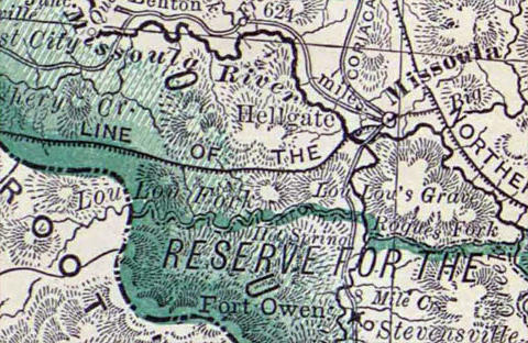
Archives and Special Collections, Maureen and Mike Mansfield Library, The University of Montana, Missoula
Lolo’s legend was elevated another degree toward historical verity with the notation on this map. Furthermore, in 1939 Lolo National Forest supervisor Ralph Space visited Lolo’s supposed grave with Wilfred W. Wright, a former supervisor of the same Forest, and following directions recounted by the Nez Perce historian and elder, Harry Wheeler. At that time it was a mound marked with a headstone, situated in a beautiful grove of pine trees beside a meadow near the confluence of Grave Creek and Lolo Creek. Space sought it out again in 1963, but intensive logging had recently been under way in the Grave Creek drainage, and the gravesite had been obliterated by the construction of a landing near the mouth of the creek where logs could be piled to await transport to lumber mills.[8]Ralph Space, The Lolo Trail: A History and a Guide to the Trail of Lewis and Clark , 2nd ed. (Missoula, MT: Historic Montana Publishing, 2001), 8.
In 2003 the presumed remains of Lolo were located with the aid of a cadaver dog, a canid trained to detect buried or otherwise hidden human remains. A historic marker was subsequently erected there by the Traveler’s Rest Chapter of the Lewis and Clark Trail Heritage Foundation. Regrettably, that effort—boldly and without apology—reaffirmed the errors of 250 years before, and added a couple of new embarrassments.
The map from which the above detail has been taken would have been of little help in finding the precise location of Lolo’s grave. For example, the creek is out of proportion as to length and direction of flow. Furthermore, the common boundary where the states of Montana and Idaho meet in this part of the Rockies is the ridge of the Bitterroot Divide, so the sources of the “Lou Lou Fork” should have been shown on the Montana side of that Divide. Grave Creek, at the mouth of which Lolo is believed to have been buried, actually meets the “Lou Lou Fork” about midway between the Bitterroot River and the state line. Given that correction, the Hot Spring would be about halfway between “Lou Lou’s Grave” and the state line. Nevertheless, the presence of the historic detail at least proves that the legendary Lolo was still on a few peoples’ minds in 1881.
Notes
| ↑1 | Isaac Ingalls Stevens (1818-1862), “Map showing the Indian tribes in Washington Territory and on the Missouri and its tributaries to the mouth of the Yellowstone” (Washington, D.C.: U.S. Office of Indian Affairs, Department of the Interior, U.S. Geographical and Geopolitical Survey of the Rocky Mountain Region, 1854). |
|---|---|
| ↑2 | Ed Pierce had been in the region a long time, by contemporary standards. He spent the winter of 1852 camped on the site of Lewis and Clark’s 1805 “Canoe Camp” while he tried to drum up Nez Perce support for a prospecting tour of the vicinity. |
| ↑3 | Resource Identifier, umt040093. The Legislature’s action conformed with the rectangular survey objectives and procedures that were defined in the Federal Land Ordinance of 1785. |
| ↑4 | A. E. Rothermich, ed., “Early Days at Fort Missoula,” in Historical Reprints, . . . Sources of Northwest History; No. 23 (Montana State University, Missoula), 3-12. |
| ↑5 | “Montana,” published by Rand McNally and Company for the Bitter Root Valley Historical Society of Hamilton, Montana. Historical Maps of Montana, The University of Montana Lifelong Learning Project, © 2004. |
| ↑6 | Wheeler, 2:78. “Map of the Nez Perce Indian Campaign,” United States Army, Dept. of the Columbia, 1877. |
| ↑7 | Rand, McNally & Company’s county and railroad map of Montana (Chicago: Rand, McNally, 1881), Mansfield Library, Archives and Special Collections, The University of Montana, Missoula. Catalog number G4250 1881.R3. |
| ↑8 | Ralph Space, The Lolo Trail: A History and a Guide to the Trail of Lewis and Clark , 2nd ed. (Missoula, MT: Historic Montana Publishing, 2001), 8. |
Experience the Lewis and Clark Trail
The Lewis and Clark Trail Experience—our sister site at lewisandclark.travel—connects the world to people and places on the Lewis and Clark Trail.
![]()
Discover More
- The Lewis and Clark Expedition: Day by Day by Gary E. Moulton (University of Nebraska Press, 2018). The story in prose, 14 May 1804–23 September 1806.
- The Lewis and Clark Journals: An American Epic of Discovery (abridged) by Gary E. Moulton (University of Nebraska Press, 2003). Selected journal excerpts, 14 May 1804–23 September 1806.
- The Lewis and Clark Journals. by Gary E. Moulton (University of Nebraska Press, 1983–2001). The complete story in 13 volumes.
This site is provided as a public service by the
![]()
Lewis and Clark Trail Alliance
with additional funding from the following:

