Let’s return to Lewis and Clark, with Gass and Pierre Cruzatte, looking at cottonwood trees near Fort Mandan, ready to make their first dugout canoes. What challenges did the Captains expect, and therefore, what kind of canoes did they need to make? They had seen the lower Missouri the year before, and had plenty of experience with wind and waves on a plains river west of the Mississippi. They knew that they would be ascending the upper Missouri in spring runoff, to its source, so they could expect a much faster river as they approached the Rockies, and they had with them Alexander Mackenzie‘s dramatic narratives from 400 miles north, in the Rockies, to warn them of extreme canoeing possibilities. They had information about the river up to the Yellowstone from traders, and Indian descriptions of the Great Falls. But the Indians followed the upper river on horseback; they did not canoe the Breaks.
Their expedition’s schedule placed them in the most difficult water during Spring runoff and seasonal headwinds. On rivers of the northern Rockies, the plains runoff sometimes begins in April, and the mountain runoff begins about mid-May, and is usually falling by mid-June. The crest is often within ten days of 1 June 1805. In the spring of 1805, we know from Clark’s daily records that the river was rising from 24 May 1805 to 31 May 1805, then holding a crest from 1–3 June 1805, then falling steadily after 4 June 1805, with occasional blips from rain.
Judging a River
What kind of river were they canoeing? A “creek” near my house, which you can cross in low water without getting your knees wet, is running with white waves at high water, about 300 cfs. A quiet, fishable stream you can wade, 30 yards wide, might run about 50-100 cfs.
As I write this, 26 May 2014, two hundred and nine years to the day after Lewis and Clark’s journal entries at Bird Rapids, called Elk Rapids in the journals, our big rivers are approaching their crests within a few miles of my house. The Clark Fork River in town is running over 10,000 cfs. Just below town, it is joined by the Bitterroot, equally large in flood, to become a river of over 20,000 cfs, 150 to 200 yards wide. Thirty miles downriver, and swollen by more side streams, it is moving at about 40,000 cfs and is 200-300 yards wide. That could have been, as we shall see, about the size of the Missouri River at Bird Rapids in 1805. Except for the one gorge at Alberton, Montana, which has significant white water, these are fairly smooth rivers, though of course dangerous at flood stage. A note on width: rapids are caused by a constriction (a narrowing of the river), by a perceptible drop, or by rocks, and most rapids are a combination of these three. Thus a slow section of river may be twice the width of a fast section a hundred yards away. Even so, the average width in slow sections of a river gives a rough impression of river size, and Lewis’s width observations remain useful.
Unless you have a lot of river experience, “40,000 cfs” has little meaning, so let’s put some pictures to these figures, to give you an idea of what they were doing on 26 May 1805. The following pictures use local rivers to illustrate different kinds of water. Why not use the actual rivers and even the particular rapids that Lewis and Clark lined and floated? Alas, The Missouri, Snake, and Columbia rivers—even the lowly Ruby, Beaverhead and Big Hole rivers—have all been dammed, and many Missouri, Clearwater, Snake and Columbia rapids have been dredged and smoothed for steamboats and now, ocean vessel ports. In addition, most of the Expedition rivers (especially the Jefferson, Beaverhead, and Big Hole) are significantly dewatered for irrigation by July. The only “pristine” rivers from the Ohio on, that is, resembling their original condition in 1805, would be the Blackfoot, which they ascended by horse but never boated, and the upper Clearwater and Lochsa rivers, which they also traversed by horse, above the Clearwater Canoe Camp at Orofino. At least, these local rivers—on or near the expedition’s route—have geological and gradient similarities common to their region.
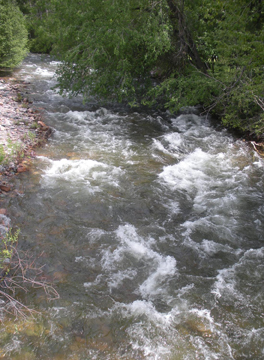
300 cfs: Rattlesnake Creek
Stream of the Little Bull Trout is what the Salish people called it.[1]Salish-Pend d’Oreille Culture Committee and Elders Cultural Advisory Council Confederated Salish and Kootenai Tribes, The Salish People and the Lewis and Clark Expedition, (Lincoln, University … Continue reading When Meriwether Lewis crossed it near its confluence with the Clark Fork River on the 4 July 1806, he noted it merely as “a stream about 15 yards wide.”
I took this photo a mile up the canyon. As it shows, the Rattlesnake is a very swift, small stream. You can see that only 300 cfs over a rocky bed can make a very strong water. It drops about 80 feet per mile (10 feet/mile produces fast water), and in the picture was running at perhaps 10 miles an hour. I have canoed it in high water, but that’s dangerous. Just one new downed tree since your last scouting could spell the end of your canoe, at the very least.
Figure 19
Rattlesnake Creek, Missoula, Montana
© 2014 William W. Bevis.
5000 cfs: Blackfoot River (Slow)
Figure 20
Near Angevine Park
To see labels, point to the image.
© 2014 William W. Bevis.
The Blackfoot River here is about 50 yards wide, and is running at 5,000 cfs. The main current, as usual, is towards the outside of the bend, here on the far side of the river. The slack water in the foreground, a good place to land, is caused by the trees and a small sand and vegetation bar (“point”) above it; in bigger water, as we shall see, that slack feature might become a big eddy with a vicious eddy line.
You can see a big difference between the wide, slow section above, and the rapid section below. The two sections of river are only a few hundred yards apart, yet are flowing at the same cfs. As the pictures below demonstrate, the same cfs can form very different rivers or sections of river, depending on gradient (the drop per mile), the stream width, and the bottom: smooth, small rocks, huge rocks, etc. Rivers having long smooth sections followed by sudden “ledge” drops are called “pool and drop” rivers. The Grand Canyon is a dramatic example: the pools may be nearly still for a mile, followed by a severe drop with a funnel entrance and huge waves. The Missouri in the Breaks is a mild pool and rapids river; the “pools” have a decent current, and only a few rapids, like Bird Rapid, might be considered drops—”a sudden decent,” as Lewis said.
5000 cfs: Blackfoot River (Rapid)
Descending the river, from upper right to lower left, the steersman faces two decisions in a few yards, at points A and B in the photo: First (A), should he take the smaller right channel, or the left channel with more water but a big rock. Second (B), should he go right or left of the rock. Right and left here mean “river right “and “river left,” as seen looking downstream. The custom is very useful when on the bank, scouting and pointing up and down the river. “Let’s go left of that rock.” “River left?” “Yeah.”
What should the steersman do here? The river left channel (foreground) has more water, so in the absence of visible features ruling out one channel or the other, he would choose the larger channel, which is the main current. Then, right away he faces the second choice: right or left of that submerged rock, which creates a white “pore over” hole that might “keep” a canoe, or turn it sideways and flip it. The choices here are easy and obvious—left, left—and were probably made upstream of the picture, behind the bushes upper right. Even on an easy river, and especially in canoes loaded with over two thousand pounds, the steersman must be alert and looking 100 to 200 yards downstream.
Lining upstream, the choices would be the opposite. The “river right” channel on the far side has shallower water and might be walkable. Much of the Jefferson River, as they ascended with full canoe loads and great effort, would have been about the size of the Blackfoot, 5,000 cfs.
The size of the Blackfoot above is also similar to that of the Clearwater River in Idaho, which the expedition descended in the fall of 1805 from their Canoe Camp at Kamiah to the Clearwater’s entrance into the Snake River at today’s Lewistown, Idaho. (See Clearwater Canoe Camp, Potlatch River, and Snake River.)
Figure 21
To see labels, point to the image.
© 2014 William W. Bevis.
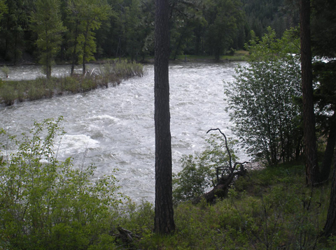
10,000 cfs: Clark Fork River
Figure 22
Above Missoula
To see labels, point to the image.
© 2014 William W. Bevis.
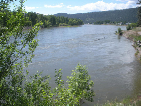
The Clark Fork River (Clark’s Fork of the Columbia, to be exact), is pictured here above Missoula, after the Blackfoot has joined it. Lewis and his contingent walked past this point early on the 4 July 1806, but aside from getting dunked when swept off the makeshift raft his men made to ferry him across the Clark’s Fork several miles downstream, neither he nor any of the rest of the Corps ever canoed on it. At this point it is a fast but calm, fairly big river of 10,000 cfs, 90 yards wide.
On the Blackfoot you would be dodging rocks. By comparison, this is an easy float down. However, the river here would be harder than the Blackfoot when lining upstream, with overhanging vegetation and deep water along the left bank in the picture (river right). A great deal of the upper Missouri above the Marias might have been in this 10-20,000 cfs range, especially above the Gates of the Mountains. In 1889, G. C. Broadhead cited an estimate that the Upper Missouri just below the Three Forks was running at 8,521 cfs in late May.[2]The upper Missouri above the Marias and the Dearborn and the Gates of the Mountains was about a 10,000 cfs river, before dams. The upper Missouri’s bed and gradient, between rapids, is similar … Continue reading
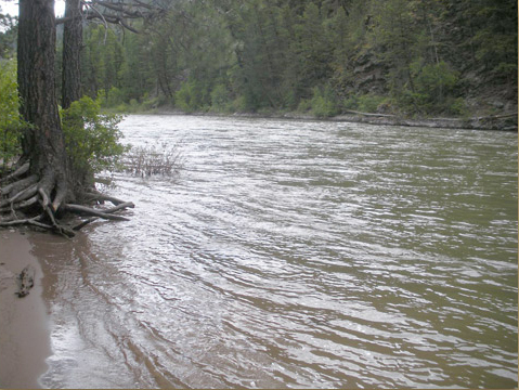
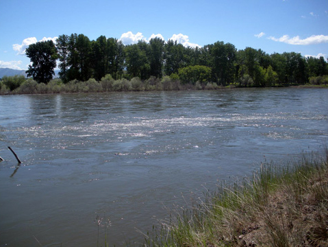
20,000 cfs: Lower Clark Fork River
Below town, the Clark Fork has been doubled by the Bitterroot River, and is 20,000 cfs and 170 yards wide. At this size, the river has considerable hydraulics: the churning of the water as it moves, although without obstacles, so that even in smooth water such as this your canoe may be turned this way or that, or pushed sideways a few yards. This is a characteristic of high water; the river is not comfortable in its bed. In the picture above, the “bay” on the right is a large eddy which sweeps around and upstream to the “point” of land upper right. Note the limb sticking up, part of a submerged tree stuck in the sand of the eddy. It reappears at the far left of the picture below (Fig. 23-b).
Figure 23-a
To see labels, point to the image.
© 2014 William W. Bevis.
20,000 cfs: Eddy Detail
Figure 23-b
To see labels, point to the image.
© 2014 William W. Bevis.
The eddy is flowing swiftly upstream; note the slight wake behind the tree limb at the left of the picture. When the eddy (B), at its top, meets the main current (A), it folds underneath. Within the brackets is a strong eddy seam or “line” about 4 to 15 feet wide, stretching 30 yards downstream, along which the two currents slide by each other in opposite directions, creating turbulence and small whirlpools. A 33′ canoe paddled across that line would have its bow in one current and its stern in another current going in the opposite direction. The boat whips around, and the crew must be ready with bracing strokes and draws to keep it from turning over. An eddy is a good place to land, but getting in and out of it can be tricky. You usually land at the bottom of the eddy, but to exit, you often have to “crash” the upstream eddy line. There is no doubt that the Lewis and Clark expedition had to perform these difficult maneuvers thousands of times. Even when ascending, they often crossed the river for better lining, and would have left from an eddy on one shore, to enter another on the opposite shore.
Lining, the crew would be pulling the canoe or pirogue upstream, but in the eddy current, which itself flows upstream, they would probably be holding the boat back with a stern rope, until they reach the point of land visible upper right in picture A. Many passages in the journals discuss crossing the river to use eddies as they ascend, and the difficulty of rounding the points of land at the top of eddies, where the boats (double manned, as Lewis says), have be dragged upstream against the full force of the current.
40,000–60,000 cfs: The Missouri River Breaks
This is my guess for the size of the Missouri River in the Breaks, in late May of 1805, and here’s why it’s a guess: The upper Missouri River has 9 dams from the Great Falls up to Toston (between Helena and Three Forks). The first dam to be built on the river, Black Eagle at the Great Falls, was finished in 1891. From Great Falls down to the Fort Peck Dam pool near the North Dakota border, a distance of over 200 miles, the Missouri runs free.
The Missouri Breaks lie within this free running section, and can still be boated, largely because the Lewis and Clark history helped create a “wild and scenic river” designation, as well as the Missouri Breaks National Monument, the Charles M. Russell National Wildlife Refuge, and other levels of protection. On modern maps, boaters think of the Breaks as lying between Fort Benton, upstream, and the Highway 191 bridge at the Kipp Recreational area, downstream (the Fort Peck Dam pool occasionally reaches above the Musselshell in high water). Commercial trips float many sections within the Breaks.
“The Breaks” denotes a general area, sometimes called “badlands.” Within this area are “The White Cliffs” which Lewis and Clark described, many steep canyon walls creating debris gullies and sharp “points,” Citadel Rock and other natural features.
Between the Musselshell River and the mouth of the Marias upstream, Lewis and Clark encountered faster water, steeper cliffs and banks, and more difficult lining. Broadhead, in 1889, observed that “Between Fort Benton and Bird’s Rapids, or for a hundred miles, there are 24 serious rapids.” Bird’s Rapids, he said, “is practically the last rapid” as you descend. Broadhead spoke before the first dam (though only by two years), but after many years of dredging for steamboats up to Fort Benton. Broadhead also observed that from St. Louis all the way up to the Yellowstone (at the North Dakota line) the Missouri River hardly changes character (a plains river), but above the Musselshell it becomes “rocky.”
This section of the Lewis and Clark journey will be the subject of the next chapter, as we follow their journals day by day from the Musselshell on 13 May 1805, upstream to the Marias on 2 June 1805, a period of rising water and great exertion, with perhaps the best journal coverage of canoe details on the entire expedition.
So how big, how fast, and how rough were the Breaks in 1805, before the dams? We must begin with the data we have now. The Breaks are downstream of the upper dams at Great Falls, and below the Marias, but above the dam pool of the Fort Peck dam. The Marias in 1805 had enough water that Lewis and Clark debated which was the main channel of the Misssouri. In this stretch of the Missouri between the Marias, at the top end, and the Musselshell at the bottom, there are two gauge stations relevant to measuring the flow in the Breaks: Virgelle at the top of the Breaks, and Landusky below the Breaks. This year those two stations are now recording about 20,000 cfs; the river is rising slowly below the dams, as the operators fill the reservoirs with spring runoff. That is, river flow in The Breaks is running about 20,000 cfs at high water, dammed. However, the record highs for those stations (even though dammed) are 45,000 and 51,000 cfs. Presumably, those years the reservoir pools filled and operators let more water run through. There are no good records before the dams.
Those statistics lead me to guess that the Missouri River at The Breaks, undammed in 1805, was easily flowing at 40-60,000 cfs at high water.
Other size comparisons confirm this. On 14 May 1805, the day the white pirogue nearly capsized, Lewis said the pirogue was “three hundred yards distant the waves so high.” Width does not equal cfs, but by 27 May 1805, farther upriver at the narrows of Bird rapid (called “Elk” in the journals, because an elk and her calf swam down the rapids as the party was ascending), Lewis said the Missouri was “about 200 yards wide, very rappid and has a perceptible fall or declination through its whole course.” In width and probably volume, that is comparable to the lower Clark Fork, before it joins the Flathead.
The undammed Yellowstone today (26 May) is running at 61,000 cfs at Forsyth, near Billings. It rises from the same mountain complex as the Missouri, and its streambed is smaller. It drains the enormous snow pack of the Yellowstone Plateau. The Missouri drains the enormous snowpack of three or four ranges west of Yellowstone, but it is dammed. I have paddled Bird Rapids on the Missouri at about 6,000 cfs, and it was a considerable riffle. At 40,000 cfs it might be at least a class III rapid. From these comparisons, and the available statistics, I am comfortable in guessing that the Missouri River in the Breaks in high water of 1805 might have been running 40-60,000 cfs and, as Lewis reported, was 200-300 yards wide.
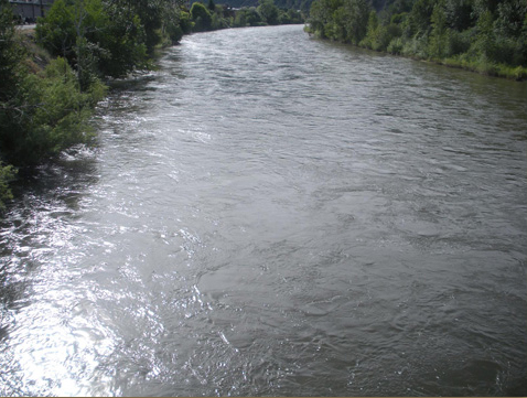
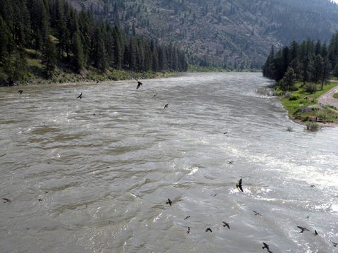
To give readers a sense of what kind of river the Breaks were, the following figures substitute the Clark Fork at 40,000 cfs, in a mild canyon with a bed and gradient similar to the Breaks. The first figure shows the river at a normal wide stretch, 250-300 yards wide, with visible current swirls.
40,000 cfs: Clark Fork River
Looking downstream past the Cliff Swallows feasting on an emerging hatch, we see small waves and mild hydraulics –”boils” of swirling water—even in this slow stretch of river. There is slack water or an eddy behind each the point on the inside of the bend river right. The Clark Fork here, about 300 yards wide, is probably quite similar—in volume, gradient, and bottom—to the Missouri River in the Breaks in 1805, in between rapids. If lining upstream, Lewis and Clark would have chosen the bank on the right in the picture, pulling up and around the points to the next eddy.
Not far around the bend in the distance, however, a rapid at 40,000 cfs shows us what Clark observed in the lower Columbia: “strong” water, with “whorls” and “suck.”
Figure 24-a
To see labels, point to the image.
© 2014 William W. Bevis.
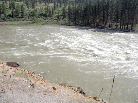
40,000 cfs: A Clark Fork Constriction
Figure 24-b
To see labels, point to the image.
© 2014 William W. Bevis.
The Clark Fork here, at 40,000 cfs, with constriction and a decent drop, and about 200 yards wide, may give some idea of Bird Rapid in the Missouri Breaks in 1805. The rapid is “bank to bank”, as Clark said of Bird rapid, and difficult indeed. You see 3′ waves, swirls and mild whirlpools. There is no easy “sneak” on the sides to avoid the wave train.
Lining upstream would not be easy. On the far bank, waves reach almost to the shore. In the foreground, where they would have lined, there is no real eddy, just turbulence flushing through. It would be hard enough to pull a 33′ dugout loaded with 3,000 pounds of gear up the near side past the black rock; then they would have to double-man it through very fast, “strong” water.
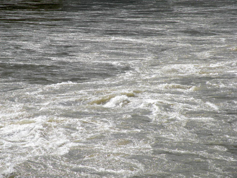
40,000 cfs: Clark Fork Whirlpool
Canoeing down a rapid of this volume in high water, the turbulence at the bottom of the waves is often as dangerous as the rapid itself. This whirlpool is only thirty yards downstream of the location in Fig. 24-b, in the tail end of the rapids, and as I watched, it was constantly forming and dissipating, and migrating ten feet upstream and down. In high water, most constriction rapids “pulse,” surging and relenting, always changing. Descending, your choice of route will often give way to improvisation. The water on both sides of the river feeds into the turbulence (on the far side the water is “shelving off” a sloping bottom), making this whirlpool almost impossible to avoid.
Five months after ascending Bird Rapids, the expedition would be canoeing down rapids in the Clearwater and Snake Rivers, rapids much longer than this one, with tricky rock gardens and no safe way to line down. See Appendix.
The Missouri River in the Breaks is a big, strong river. It’s not really “big water;” we usually save that term for over 100,000 cfs, as in the Mississippi, which the Missouri will join in 2,000 miles, making the third longest river system in the world (after the Nile and the Amazon). However, 40,000 cfs is a lot of water in a 200 yard wide streambed with “a perceptible fall.” I am confident that they faced at least class II-III rapids, boils and swirls, debris, and very, very strong, “rappid” water.
Figure 24-c
To see labels, point to the image.
© 2014 William W. Bevis.
Notes
| ↑1 | Salish-Pend d’Oreille Culture Committee and Elders Cultural Advisory Council Confederated Salish and Kootenai Tribes, The Salish People and the Lewis and Clark Expedition, (Lincoln, University of Nebraska Press, 2005), 46. |
|---|---|
| ↑2 | The upper Missouri above the Marias and the Dearborn and the Gates of the Mountains was about a 10,000 cfs river, before dams. The upper Missouri’s bed and gradient, between rapids, is similar to the Clark Fork in this picture. The study also measured the three tributaries above the forks: the Gallatin was (rounded off) 2,100, the Madison 2,700, and the Jefferson almost 4,000 cfs, similar to the Blackfoot above. |