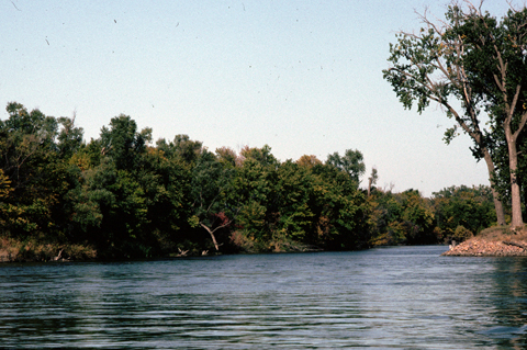
Mouth of the Vermillion River
© 1992 by Jim Peterson.
The stream, at the mouth of which the ten-man contingent from the Corps left the white pirogue, and which they followed part of the way to the storied mound, was labeled the Kenvill River on John Evans‘s manuscript map of the Missouri River[1]Moulton, Atlas, map 7., a copy of which was in the expedition’s portable library. Clark understood that an Indian name for it was Washisha, “the river of white Stone,” which would be white sedimentary claystone. But if it was important enough to serve as the basis it would properly have been white clay, a mineral that was used by Indians as body paint. This can only be explained as Clark’s (or his informant’s) misunderstanding of a French word for stone: pierre; soil is terre; “clay” is argile]. Subsequently it was again renamed, successively, Washisha (“white stone”), White Earth, Smoky Earth, and the Redstone—the last one imposed for unknown reasons by Clark when the party passed it on 3 September 1806, en route home. Perhaps he had learned that the Dakota Indians called it Wa-se-sa Wa-kpa, meaning red stone, which some anonymous French traveler later translated as Vermillion, by which it is still known.[2]There are also Vermillion Rivers in Ohio, Indiana, Illinois (two of them, plus two “Little Vermillion” Rivers), Louisiana, Minnesota, and Wisconsin. Most gained their name from the … Continue reading The red stone is ocher, a hydrated iron oxide once commonly used by Native peoples as a decorative coloring for various purposes, including body paint. They also obtained “white earth”—properly “white clay“—from the valley for a similar use, which justifies Clark’s first-mentioned name.[3]Moulton, Journals, 8:507, 10n.
Gradually, during the 190 years between the day the Corps passed it in September 1806, and the completion of the last of 15 dams on the Missouri River in 1966, the mouth of the Vermillion River migrated about 2.5 miles southeast from its 1804 location, so it is pointless to try to retrace the exact route that the captains and their men followed to reach the Mound. Besides, much like the Missouri’s fate, the free roving channel of the Vermillion has been somewhat straightened or otherwise restrained over the years, eliminating the continually shifting meanders that once gave dynamic life to it—deep holes and shallow shoals that supported their respective insect species, eddies and chutes with sudden changes of velocity, varieties of vegetation, and slow-paced evolutions in each of those parameters.
Notes
| ↑1 | Moulton, Atlas, map 7. |
|---|---|
| ↑2 | There are also Vermillion Rivers in Ohio, Indiana, Illinois (two of them, plus two “Little Vermillion” Rivers), Louisiana, Minnesota, and Wisconsin. Most gained their name from the reddish-brown color of their water, contributed by the reddish clay they flow through. |
| ↑3 | Moulton, Journals, 8:507, 10n. |