Clark’s Sketch of the Long & Short Narrows of the Columbia River (detail)
To see labels, point to the image.
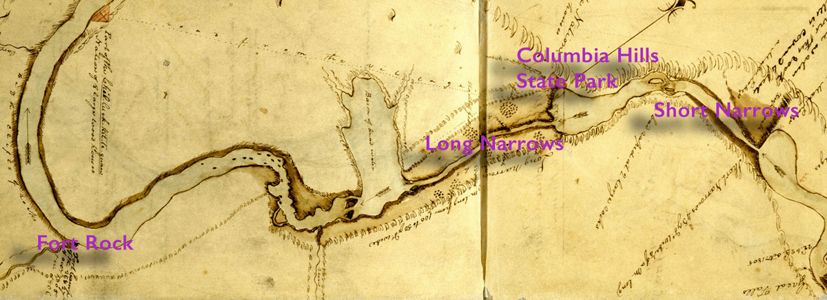
American Philosophical Society, Codex H:2-3.
To see the complete map with detailed annotations, see Clark’s Columbia River Maps.
The Short Narrows
October 24 dawned “fare after a beautifull night” with no hint of attack, and the Corps passed the Short Narrows. Here the Columbia was constricted from 200 yards wide, by Clark’s estimate, to only 45 yards; the black basalt rocks stretched for a quarter of a mile. Compressed into that space, the Columbia was “an agitated gut Swelling, boiling & whirling in every direction.” Even so, Pierre Cruzatte and Clark agreed that they could run the canoes through, first putting ashore “all the men who could not Swim and Such articles as was most valuable to us Such as papers Guns & ammunition.” With Indians watching from the banks, two canoes were sent through successfully, and then the other two followed. Clark wrote, “we passed Safe to the astonishment of all the Inds.”
Many Houses
Interior of a Ceremonial Lodge, Columbia River, 1846
Paul Kane (1810–1871)
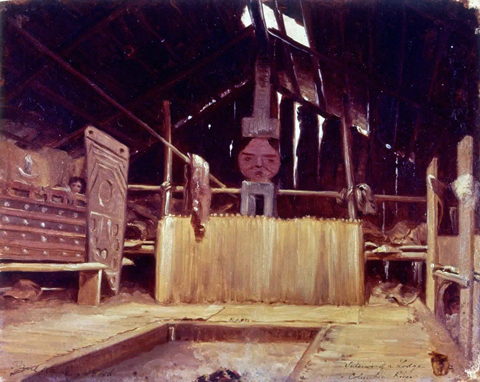
Courtesy, Stark Museum of Art. Oil on paper, 9½” x 11½” (24.1 x 29.1 cm), Stark Museum of Art, Orange, Texas, 31.78/210, WOP 13.
On 24 October 1805, Clark wrote that they saw “the first wooden houses . . . Since we left those in . . . the Illinois.”
Landing at what is now Columbia Hills State Park, Clark noted that here they found the “first wooden houses in which Indians have lived Since we left those in the vicinity of the Illinois.” Sunken six feet into the earth, their cedar-bark roofs rose four feet above ground. Each lodge measured about 20 by 30 feet, and housed about eight men and twenty or so women and children. Sgt. Patrick Gass, the expedition’s carpenter, pronounced that “This village has better lodges than any on the river above . . . tolerably comfortable houses.”
Clark understood the native people’s name as “Echelute,” which instead was likely the name of the speaker’s village in reply to his inquiry. The Corps of Discovery made camp near the Wishram village. Ordway said, “we bought a number of fat dogs, crambries and white cakes of root bread”—made of either wapato or cous—for their meal. In the evening, according to Clark, “the principal Chief from the nation below visited, along with several of his tribesmen, and the captains “accomplished” a peace treaty between the Chinookans and the Nez Perces that put them “on the most friendly terms with each other.” Following that the Corps smoked with men of the nearby village, Cruzatte fiddled and the men danced “which delighted the natives, who Shew every civility towards us.”
The Long Narrows
Long Narrows
“bad whorl & Suck”
Edward S. Curtis (1868–1952)
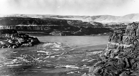
Oregon Historical Society, #92215.
Edward S. Curtis (1912), Photogravure print from The North American Indian, Vol. 9, Plate 302, Original size, 36 x 44 cm (c. 14 x 17-1/8 in)
The white line on the rocks at right was the annual high-water mark.[1]Emory and Ruth Strong, “Seeking Western Waters; The Lewis and Clark Trail from the Rockies to the Pacific (Portland: Oregon Historical Society Press, 1995), 98. Indeed, later white travelers who arrived here during the peak of the spring freshet often observed that the falls and rapids were completely submerged and consequently all but invisible. Hidden at all times were the vertical holes from one to twelve feet in diameter that pebble-and-sand-laden whirlpools had drilled deep into the bedrock in the narrow channel.[2]Emory Strong, Stone Age on the Columbia River (Portland: Binford & Mort, 1959), 44.
Clark’s description of the Long Narrows, written 25 October 1805, scarcely betrays any anxiety about the prospects of getting through it safely:
Capt Lewis and my Self walked down to See the place the Indians pointed out as the worst place in passing through the gut, which we found difficuelt of passing without great danger, but as the portage was impractiable with our large Canoes, we Concluded to Make a portage of our most valuable articles and run the canoes thro accordingly on our return divided the party Some to take over the Canoes, and others to take our Stores across a portage of a mile to a place on the Chanel below this bad whorl & Suck, with Some others I had fixed on the Chanel with roapes to throw out to any who Should unfortunately meet with difficuelty in passing through; great number of Indians viewing us from the high rocks under which we had to pass, the 3 first Canoes passed thro very well, the 4th nearly filled with water, the last passed through by takeing in a little water, thus Safely below what I conceved to be the worst part of this Chanel, felt my Self extreamly gratified and pleased.
On the 25th, men were stationed along the shore with ropes to throw out “in Case an accidence happened at the Whirl &c,” and the canoes ran the Long Narrows one at a time. Only the third boat had trouble, and “nearly filled with water,” but “we got her Safe to shore.” After traveling two more miles before passing out of the rapid Long Narrows and back onto the wide Columbia, the Corps beached its canoes at Mill Creek on the Oregon side, and established the camp they called variously Fort Rock or Rock Fort: “we took possession of a high Point of rocks to defend our Selves in Case the threts of those Indians below Should be put in execution against us.” But the day’s single meeting with natives resulted only in smoking together, and the captains’ awarding a small medal to one chief. From them or others that day, Twisted Hair and Tetoharsky “purchased a horse each with 2 robes” and headed home.
One imagines that Pierre Cruzatte, the Corps’ professional river pilot, would have been in the bow of the lead canoe, reading the rapids like an instruction manual. Photographer Edward Curtis, who descended the Columbia in the spring of 1910 for the express purpose of seeing it from Lewis and Clark’s perspective and went through this fearsome whirlpool at the bow of his own canoe, listed the basic qualifications for the role. “In swift water the man in the bow should have something in his head, a good deal in his back, be quick on his feet and quite indifferent as to the future.”[3]Mike Gidley, ed., Edward S. Curtis and the North American Indian Project in the Field (Lincoln: University of Nebraska Press, 2003), 89. What is more, judging from Clark’s final exultant expression, one suspects he really had had fun, and before an appreciative audience to boot.
Past the Narrows
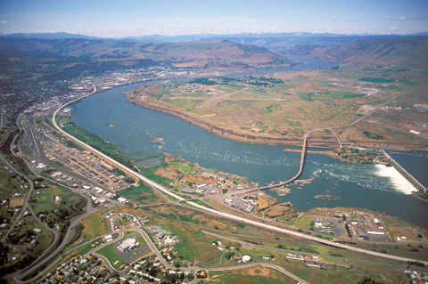
From the local Indians’ point of view, those thirty-three strangers and their dog put on quite a spectacle for four days in late October 1805, easing their clumsy dugouts down by ropes through the Great Falls (Celilo Falls) and the Short and Long Narrows–later called “The Dalles,” a French-Canadian term denoting rapids confined by rock walls.
On the 25th, the Corps coasted by the last few rocky spots into “a butifull jentle Stream of about half a mile wide,” and beached their battered canoes at “a high point of rocks” below today’s Mill Creek (just around the bend, above center in the picture). It provided, Clark observed with satisfaction, a secure redoubt against any “designs of the natives, Should They be enclined to attack us.” Better yet, the hunting thereabouts was promising, for a change.
There really was no need for him to have been on the defensive. On the 26th, two chiefs and fifteen Indian men in a single canoe crossed the river for a visit. That evening, Pierre Cruzatte cast a spell over the assembled Indians with his fiddle, which was much more effective than any pompous diplomatic talk. “At night a fire was made in the middle of our camp, and as the Indians sat round it our men danced to the music of the violin, which so delighted them that several resolved to remain with us all night.”
Beyond the farthest bend, the Columbia Gorge rifts the Cascade Range, which separates the desert of the Columbia Plateau from the continent’s moist coastal margin. On the way home in April 1806, Lewis noticed the climatic change again when he emerged from the gorge. “Even at this place which is merely on the border of the plains of Columbia,” he wrote, “the climate seems to have changed; the air feels dryer and more pure.”
Notes
| ↑1 | Emory and Ruth Strong, “Seeking Western Waters; The Lewis and Clark Trail from the Rockies to the Pacific (Portland: Oregon Historical Society Press, 1995), 98. |
|---|---|
| ↑2 | Emory Strong, Stone Age on the Columbia River (Portland: Binford & Mort, 1959), 44. |
| ↑3 | Mike Gidley, ed., Edward S. Curtis and the North American Indian Project in the Field (Lincoln: University of Nebraska Press, 2003), 89. |