Starvation Creek Falls
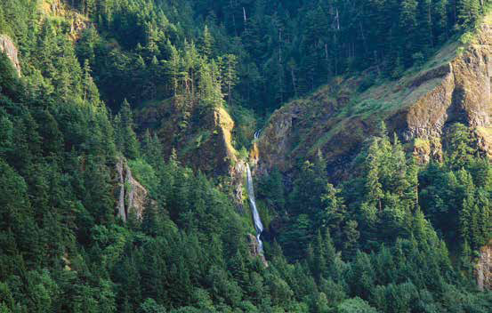
© John W. Jengo. Used by permission.
View of Starvation Creek Falls, one of the “4 Cascades” noted by William Clark on 30 October 1805, dwarfed by massive exposures of the Grande Ronde Basalt. Because the basalt layers on the Oregon side of the Columbia River dip away from the river, precluding any large-scale slippage into the valley, more sheer cliffs and consequently more waterfalls have been formed on the Oregon side of the Columbia River Gorge.
Latourell Falls
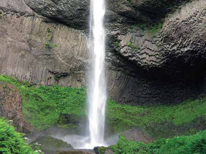
© John W. Jengo. Used by permission.
Among the second major grouping of waterfalls passed by the expedition (which includes Horsetail, Multnomah, and Bridal Veil Falls), Latourell Falls beautifully exposes the columnar-jointing of a Sentinel Bluffs Member flow, the youngest Grande Ronde Basalt in the Columbia River Gorge. Grande Ronde Basalts compose at least 26 of the approximate 31 basalt flows that are present in the Gorge region.
Multnomah Falls
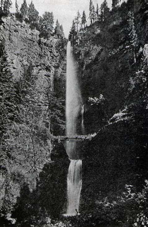
Photographer unknown. From Olin D. Wheeler, The Trail of Lewis and Clark. See also Wheeler’s “Trail of Lewis and Clark”.
Wah Gwin Gwin Falls
Once past the White Salmon River (the expedition’s “Canoe Creek”), Clark took note of the first of many waterfalls the expedition would encounter in the Gorge:
[29 October 1805:] a butifull cascade falling over a rock of about 100 feet.
It seems certain this is Wah Gwin Gwin Falls, at the present-day location of the historic Columbia Gorge Hotel, just west of Hood River, Oregon. The falls were notable enough to be included on Clark’s route map (labeled as “Cascade”) and its mapped location is consistent with his Elkskin-bound journal course and distance notes where the falls were described as “a small stream of water falls over a rock of 100 feet on the Lard Side.”[2]As depicted on Moulton, ed., Atlas, 1: Map 78 and consistent with John Ordway‘s October 29, 1805, journal entry “Saw a beautiful Spring on the Lard. Side, which run off a high clift of … Continue reading
Four Remarkable Cascades
A spectacular array of falls were observed downriver by Clark on 30 October 1805:
Saw 4 Cascades caused by Small Streams falling from the mountains on the Lard. Side.
Three of Clark’s “4 Cascades,” moving from upstream to downstream, are most assuredly Starvation Creek Falls, Cabin Creek Falls, and Wonder Creek/Lancaster Falls, all strikingly visible from the river today. The fourth cascade will probably remain speculative because the most likely candidate, the falls coming off Warren Creek, were re-routed when the creek was diverted in the late 1930s and, therefore, are no longer observable in their original state.[3]Various waterfall surveys available online such as www.oregonhikers.org/field_guide/hole_in_the_wall_falls have the Warren Falls diversion occurring in 1938, creating a new 96-foot high waterfall … Continue reading Other possibilities for the fourth cascade include Lindsey Creek Falls and Summit Creek Falls, but these are much smaller features and are somewhat offset downriver from the tight grouping of cascades Clark depicted on his route map.[4]Moulton, ed., Atlas, 1: Map 78. The heights of Lindsey Creek Falls (50 feet) and Summit Creek Falls (30 feet) make it less likely that they were noted by Clark, as compared to Starvation Creek Falls … Continue reading
The other major grouping of notable waterfalls observable from the river are located some twenty-one to twenty-nine miles downriver from Lancaster Falls. On the return journey between Horsetail Falls and Latourell Falls (which encompasses Oneonta, Multnomah, Wahkeena, and Bridal Veil Falls) Lewis noted that:
[9 April 1806:] the most remarkable of these casscades falls about 300 feet perpendicularly over a solid rock into a narrow bottom of the river on the south side.
On the Larboard Side
As typified in the captains’ documentation of waterfalls in the Gorge, the majority of falls are on the south (Oregon) side of the Columbia River. Although Lewis mentioned on April 14, 1806, that “some handsome cascades are seen on either hand tumbling from the stupendious rocks of the mountains into the river,” no waterfalls are noted on the north (Washington State) side of the river on the expedition route maps.[5]Moulton, ed., Atlas, 1: Maps 78 and 79. This phenomenon is a direct result of the unstable geological formations that underlie the Columbia River Basalt Group (CRBG).[6]See Columbia River Basalts. There is an overall dip or tilt of the CRBG basalt layers to the south throughout the Gorge and these layers are underlain by a thick clay saprolite.[7]Saprolite is a soft, typically clay-rich, wholly decomposed rock formed in place by chemical weathering per Robert L. Bates and Julia A. Jackson, eds., Glossary of Geology, Second Edition (Falls … Continue reading This relatively impermeable layer traps percolating groundwater to become a slippery and unstable surface, promoting large landslides on the Washington State side to literally slip southward in the direction of the dip angle of the rocks into the valley. These massive landslides (including the Bonneville landslide complex at the Cascades discussed below) have served to cut back the cliff slopes on the north side of the river, resulting in a reduced number of sheer vertical drops that would lend themselves to the formation of waterfalls. Conversely, there have been fewer and considerably smaller mass movements on the south side (because the basalt layers dip away from the river, thus precluding any large-scale slippage into the valley). Because of this structural orientation, and aided in places by Columbia River undercutting (where the river has been pushed south by the north-side landslides),[8]O’Connor and Burns, “Cataclysms and Controversy,” 240. According to O’Connor and Burns (p. 239), mapped landslides along the Columbia River between the Hood and Sandy Rivers … Continue reading more sheer cliffs have formed on the Oregon side, and consequently a greater number of waterfalls have developed.
Effects of the Missoula Floods
It is also thought the Missoula floods played a role in triggering large landslides because the floods repeatedly inundated and saturated the lower elevations of the Gorge while undercutting the valley walls.[9]Ibid., 240. Geologists see evidence in the Columbia Valley between Wallula Gap and Portland of at least 25 floods discharging greater than 1 million cubic meters per second, per Gerardo Benito and … Continue reading Evidence of the Missoula floods is not as obvious to the casual observer as in the Channeled Scablands, but anyone visiting Wah Gwin Gwin Falls at the Columbia Gorge Hotel should take a stroll in the back garden, some 313 feet above sea level, to see the outcrop of smooth, grooved basalt that was vigorously scoured out and polished by episodes of deep, raging flood waters.
Notes
| ↑1 | John W. Jengo, “After the Deluge: Flood Basalts, Glacial Torrents, and Lewis and Clark’s “Swelling, boiling & whorling” River Route to the Pacific,” Part 2, We Proceeded On, November 2015, Volume 41, No. 4, the quarterly journal of the Lewis and Clark Trail Heritage Foundation. The original, full-length article is provided at lewisandclark.org/wpo/pdf/vol41no4.pdf#page=10. |
|---|---|
| ↑2 | As depicted on Moulton, ed., Atlas, 1: Map 78 and consistent with John Ordway‘s October 29, 1805, journal entry “Saw a beautiful Spring on the Lard. Side, which run off a high clift of rocks, and fell of[f ] the clift upwards of a hundred feet perpinticular.” |
| ↑3 | Various waterfall surveys available online such as www.oregonhikers.org/field_guide/hole_in_the_wall_falls have the Warren Falls diversion occurring in 1938, creating a new 96-foot high waterfall called Hole-in-the-Wall. Accessed 16 September 2015. |
| ↑4 | Moulton, ed., Atlas, 1: Map 78. The heights of Lindsey Creek Falls (50 feet) and Summit Creek Falls (30 feet) make it less likely that they were noted by Clark, as compared to Starvation Creek Falls (227 feet), Cabin Creek Falls (220 feet), and Lancaster Falls (303 feet). |
| ↑5 | Moulton, ed., Atlas, 1: Maps 78 and 79. |
| ↑6 | See Columbia River Basalts. |
| ↑7 | Saprolite is a soft, typically clay-rich, wholly decomposed rock formed in place by chemical weathering per Robert L. Bates and Julia A. Jackson, eds., Glossary of Geology, Second Edition (Falls Church, Virginia: American Geological Institute, 1980), 556. The poorly-consolidated Eagle Creek Formation that separates the CRBG from the underlying slippery saprolite, abets the instability. An excellent outcrop of this clayey conglomerate with notably abundant rounded porphyritic andesite clasts, debris flow breccia, pebbly volcaniclastic sandstone, silt-stone, and air-fall tuff can be examined just off Exit 41 heading east-bound on I-84, about 350 feet before the end of the exit ramp. |
| ↑8 | O’Connor and Burns, “Cataclysms and Controversy,” 240. According to O’Connor and Burns (p. 239), mapped landslides along the Columbia River between the Hood and Sandy Rivers cover about 50 square miles. |
| ↑9 | Ibid., 240. Geologists see evidence in the Columbia Valley between Wallula Gap and Portland of at least 25 floods discharging greater than 1 million cubic meters per second, per Gerardo Benito and James (Jim) E. O’Connor, “Number and Size of Last-Glacial Missoula Floods in the Columbia River Valley between the Pasco Basin, Washington, and Portland, Oregon,” Geological Society of America Bulletin, 115:5 (May 2003), 624-638. These flows were 185 times greater than average annual flow of the Columbia River today. |