Wallula Gap
Touchet Beds Outcrop
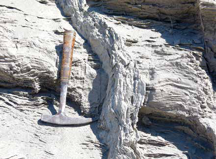
© John W. Jengo. Used by permission.
Outcrop of Touchet Beds at the confluence of the Columbia and Walla Walla Rivers, very near the expedition’s 29 April 1806, return encampment.
These horizontally bedded slackwater deposits, including the post-depositional vertical clastic dikes, may have been the source of the “keffekill” mineralogical specimen collected by Meriwether Lewis. The outcrop scale is indicated by the one-foot long rock hammer.
Upon reaching the “great Columbia river,” Clark’s initial observation as the expedition set out downriver captured the essence of the area’s geology and geography:
[18 October 1805:] the river passes into the range of high Countrey at which place the rocks project into the river from the high clifts which is on <both> the Lard. Side about . of the way across and those of the Stard Side about the Same distance, the Countrey rises here about 200 feet above The water and is bordered with black rugid rocks.
The “range of high Countrey” was the Horse Heaven Hills and the “black rugid rocks” that are its foundation at Wallula Gap consist of dramatic exposures of the thick Frenchman Springs Member of the Wanapum Basalt capped by the Umatilla, Pomona and Elephant Mountain Members of the Saddle Mountains Basalt.[2]See on this site Columbia River Basalts.
Enigmatic Keffekill Specimen
Along this stretch of river Meriwether Lewis apparently collected an enigmatic and long-missing mineral specimen that was never documented in the expedition journals or in any expedition-related specimen list or correspondence. The documentation of this specimen’s existence is only found in the c. 1812 hand-written mineralogical specimen catalogue of Adam Seybert, physician, gentleman-scientist, and Philadelphia’s leading mineralogy expert:
“Keffekill. found at the Wallenwaller nation on Columbia River. Captn. Lewis.”[3]John C. Greene and John G. Burke, “The Science of Minerals in the Age of Jefferson,” Transactions of the American Philosophical Society, 68:4 (July 1978): 30. The existence of this and … Continue reading
This was the same Adam Seybert who added supplemental mineralogical comments to augment Lewis’s original descriptions of the mineral specimens sent back from Fort Mandan in April 1805.[4]For details on the important role Adam Seybert played in the subsequent fate of the entire Lewis and Clark mineral collection and how he likely obtained at least thirty-four Lewis and Clark … Continue reading Identifying the locale as being coincident with the “Wallenwaller” [Walla Walla] nation, where the expedition encountered the hospitable Chief Yellepit, places the collection site somewhere in the vicinity of the Columbia-Walla Walla River confluence or perhaps a short distance downriver. The specimen is lost along with its presumed identification tag, so it is not known whether Lewis originally assigned the “keffekill” classification using the Kirwan volumes as a guide or if this was Seybert’s identification. We know Lewis was still referring to Elements of Mineralogy because of his attempt at Fort Clatsop in January 1806 to describe the mineralogy of the “white earth” specimen collected on Tillamook Head,[5]Lewis was attempting to ascertain whether there was “magnesia” or “silex” [silica] in the “white earth” specimen. It is interesting that Kirwan also listed these … Continue reading but it is more probable Seybert made the identification in Philadelphia.
In the early nineteenth century, “keffekill,” also known as meerschaum, was described as a very fine-grained, yellowish, grayish-white, or white clayey marl soft enough upon excavation to be readily made into tobacco pipes or mixed with water to make a cleansing soap.[6]A description of “keffekill” superior to Kirwan’s can be found in Robert Jameson, A System of Mineralogy in Which Minerals are Arranged According to the Natural History Method, … Continue reading Whatever specimen Lewis did collect, it was probably not the hydrous magnesium silicate mineral sepiolite, the present-day equivalent of “keffekill” and “meerschaum.” If not actually “keffekill’ then, what was the presumably yellowish to grayish-white deposit Lewis did sample and secondly, what would such an apparently incongruous light-colored deposit be doing in an extensive terrain of black basaltic rocks? The numerous islands and natural river banks along this stretch are drowned by the impoundment behind McNary Dam, frustrating any direct inspection, so if we want to contemplate “keffekill” sample possibilities, we should start with the Missoula floods that created the Channeled Scablands.
Extent of Glacial Lake Missoula Floodwaters and Southern Extent of the Cordilleran Ice Sheet
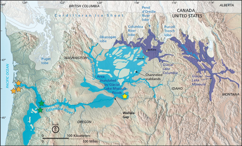
Graphic by Trista Thornberry-Ehrlich (Colorado State University) from a U.S. Geological Survey diagram, available at http://pubs.usgs.gov/sir/2005/5227/section5.html (accessed 30 July 2013). Base map by Tom Patterson (NPS), available at http://www.shadedrelief.com/physical/index.html (accessed 30 July 2013).
“The area affected by the Missoula floods is shown in light blue. Lake Lewis formed behind Wallula Gap and encompassed the present-day location of Whitman Mission National Historic Site (yellow star). The green stars indicate the approximate location of Fort Vancouver National Historic Site. Orange stars represent the general location of Lewis and Clark NHP [National Historic Park] sites.”[7]John Graham, “Geologic Resources Inventory Report,” Lewis and Clark National Historic Park, Natural Resource Report NPS/NRSS/GRD/NRR—2019/2023 (U.S. National Park Service, 2019), 47.
Lake Lewis and Touchet Bed Deposits
The “high clifts” of Wallula Gap the expedition passed on 18 October 1805, were the upstream funnel constriction of the Missoula flood outbursts, being the sole outlet for the Columbia River watershed of eastern Washington.[8]The Wallula Gap was not the only obstacle encountered by Missoula floodwaters on their path to the Pacific Ocean. Other major constrictions identified by geologists downstream of Wallula Gap include … Continue reading Despite being a mile wide, Wallula Gap could “only” pass about 211,900,000 cubic feet per second (cfs) of flow during the greatest of the Lake Missoula outbursts through the Channeled Scablands (a staggering 1.59 billion gallons per second),[9]Roger P. Denlinger and Daniel R.H. O’Connell, “Simulations of Cataclysmic Outburst Floods from Pleistocene Glacial Lake Missoula,” Geological Society of America Bulletin, 122:5/6 … Continue reading which was not nearly enough capacity to discharge the full floodwater volume roaring down the Columbia River.[10]A higher modeling result of 10 million cubic meters per second (353.1 million cfs) through Wallula Gap was calculated by James E. O’Connor and Victor R. Baker using a 1-dimensional … Continue reading The excess sediment-laded floodwaters, constricted for days from flowing through the hydraulic dam at the Gap, rose to heights up to 900 feet over normal river level and backflooded up the Snake, Walla Walla, and other Columbia River tributaries. This immense temporary lake would be named Lake Lewis in the twentieth century in honor of Meriwether Lewis. When the backwaters of each glacial outburst slackened with decreases in current velocity, sedimentary sequences of sand and silt called rhythmites were deposited.[11]The exact number of Missoula floods, which could number more than 89, may never be completely established, but at least 40 separate catastrophic Missoula floods have been identified in the Walla … Continue reading
Exposures of these rhythmite deposits can be seen along stream banks, and in road and railroad cuts, including at the present-day mouth of the Walla Walla River’s confluence with the Columbia River. Close examination of these outcrops and other superb exposures just north of the town of Touchet, Washington (which lent its name to these Touchet Beds), reveal multiple layers of a yellowish gray to grayish-white, fine-grained to very fine-grained sand and silt. An intriguing “keffekill” sample candidate for sure, especially given the wide distribution of Touchet Beds in this area, thus increasing the odds of an encounter with the mineralogy-minded Meriwether Lewis. Yet, Touchet Bed silts in this area are not as fine-grained as clayey marl, one of the distinguishing characteristics of true keffekill that would have convinced either Lewis or Seybert that the expedition specimen was “keffekill.” Perhaps Lewis sampled a layer of thinly laminated clayey fine silt found associated with some Touchet Bed rhythmites or one of the thick clay and silt coatings lining the walls of near-vertical clastic dikes that permeate certain Touchet Beds locales.[12]Two other possibilities for the “keffekill” sample should be considered, although the opportunities for encountering these deposits were much less likely than the extensive Touchet Beds. … Continue reading
Keffekill Specimen Date
Because the expedition passed through this area twice, we don’t know if the faux “keffekill” specimen was collected in October 1805 or April 1806, but an April 1806 collection date is favorable for several reasons. Firstly, such a specimen was more likely to survive the trip back East having missed the precarious journey to Fort Clatsop and back. Secondly, the expedition spent three nights (27-29 April 1806) in the vicinity of likely collection sites, affording Lewis more time to conduct his mineralogical sampling. Lastly, their encampment of 29 April 1806, placed the expedition in very close proximity to extensive exposures of light-colored deposits, including Touchet Beds along the banks of the Walla Walla River, a water body we know Lewis examined very closely.[13]According to his journal entry for 29 April 1806, Lewis noted the width, water depth, and bank height of the Walla Walla River, and its river bed composed of “gravel principally with some sand … Continue reading
Notes
| ↑1 | John W. Jengo, “After the Deluge: Flood Basalts, Glacial Torrents, and Lewis and Clark’s “Swelling, boiling & whorling” River Route to the Pacific,” Part 1, We Proceeded On, August 2014, Volume 40, No. 3, the quarterly journal of the Lewis and Clark Trail Heritage Foundation. The original, full-length article is provided at https://lewisandclark.org/wpo/pdf/vol40no3.pdf#page=9. |
|---|---|
| ↑2 | See on this site Columbia River Basalts. |
| ↑3 | John C. Greene and John G. Burke, “The Science of Minerals in the Age of Jefferson,” Transactions of the American Philosophical Society, 68:4 (July 1978): 30. The existence of this and other specimens collected west of the Continental Divide, including a magnetic sand sample collected at the mouth of the Columbia River, irrevocably proved the captains continued their mineral collecting all the way to the Pacific Ocean. |
| ↑4 | For details on the important role Adam Seybert played in the subsequent fate of the entire Lewis and Clark mineral collection and how he likely obtained at least thirty-four Lewis and Clark mineralogical specimens for his private collection, including the “keffekill” specimen, see John W. Jengo, “‘Specimine of the Stone’: The Fate of Lewis and Clark’s Mineralogical Specimens,” We Proceeded On, 31:3 (August 2005): 17-26. |
| ↑5 | Lewis was attempting to ascertain whether there was “magnesia” or “silex” [silica] in the “white earth” specimen. It is interesting that Kirwan also listed these minerals as the principal components of keffekill. See Kirwan, Mineralogy, 1:144-145. |
| ↑6 | A description of “keffekill” superior to Kirwan’s can be found in Robert Jameson, A System of Mineralogy in Which Minerals are Arranged According to the Natural History Method, Third Edition (Edinburgh, Scotland: Archibald Constable & Company, 1820), 2: 283-285. |
| ↑7 | John Graham, “Geologic Resources Inventory Report,” Lewis and Clark National Historic Park, Natural Resource Report NPS/NRSS/GRD/NRR—2019/2023 (U.S. National Park Service, 2019), 47. |
| ↑8 | The Wallula Gap was not the only obstacle encountered by Missoula floodwaters on their path to the Pacific Ocean. Other major constrictions identified by geologists downstream of Wallula Gap include Rowena Gap, Mitchell Point, and Crown Point in the Columbia River Gorge, and the Kalama Narrows downstream of Portland, which caused significant backflooding of the Willamette Valley. See James E. O’Connor and Richard B. Waitt, “Beyond the Channeled Scabland: A Field Trip to Missoula Flood Features in the Columbia, Yakima, and Walla Walla Valleys of Washington and Oregon—Part 1,” Oregon Geology, 57:3 (May 1995): 54. |
| ↑9 | Roger P. Denlinger and Daniel R.H. O’Connell, “Simulations of Cataclysmic Outburst Floods from Pleistocene Glacial Lake Missoula,” Geological Society of America Bulletin, 122:5/6 (May/June 2010): 678-689. This discharge of 211.9 million cfs, which I calculated from the Denlinger and O’Connell’s modeling result of 6 million cubic meters per second, is over 1,100 times greater than the mean annual flow (190,700 cfs) of the Columbia River at The Dalles. |
| ↑10 | A higher modeling result of 10 million cubic meters per second (353.1 million cfs) through Wallula Gap was calculated by James E. O’Connor and Victor R. Baker using a 1-dimensional step-backwater model, “Magnitudes and Implications of Peak Discharges from Glacial Lake Missoula,” Geological Society of America Bulletin, 104:3 (March 1992): 267-279, and confirmed in Benito and O’Connor, “Number and Size,” 115:5, 636, but I chose to cite the more conservative 6 million cubic meters per second (211,900,000 cfs) value because it may more accurately account for the downstream flow restriction through the Columbia River Gorge as modeled by Denlinger and O’Connell using a geometrically more sensitive 2-dimensional computation, “Simulations,” 122:5/6, 686. Either way, with estimates of the peak inflow into the Pasco Basin ranging from 22 to >25 million cubic meters per second, it is readily apparent why more than half of the greatest Missoula flood discharges hydraulically ponded upstream of the Wallula Gap constriction. |
| ↑11 | The exact number of Missoula floods, which could number more than 89, may never be completely established, but at least 40 separate catastrophic Missoula floods have been identified in the Walla Walla River valley, per Richard B. Waitt, Jr., “About Forty Last-Glacial Lake Missoula Jökulhlaups through Southern Washington,” Journal of Geology, 88:6 (November 1980): 653-679. There is recent consideration that the number of floods in the Walla Walla Valley may have been between 50 and 62. Current thinking has early, larger floods carving much of the Channeled Scablands and leaving higher elevation deposits, with subsequent, smaller events flooding less and less of the Channeled Scablands and depositing lower-elevation rhythmite sections; see Benito and O’Connor, “Number and Size,” 115:5, 637. Even these dozens of “smaller” floods, discharging at least 1 million cubic meters per second, were 185 times greater than mean annual flow of the Columbia River at The Dalles today. |
| ↑12 | Two other possibilities for the “keffekill” sample should be considered, although the opportunities for encountering these deposits were much less likely than the extensive Touchet Beds. The first would be a yellowish-gray, grayish white to white Mazama ash layer originally deposited in this region from a massive eruption of Mount Mazama (present-day location of Crater Lake, Oregon) about 7,700 calendar years ago, or perhaps one of the older, but much thinner, Mount St. Helens tephra deposits that are interbedded with certain Touchet Bed rhythmites. If the “keffekill” specimen were collected downstream of Wallula Gap, the other possibility could be a slackwater deposit from former Lake Condon, which was the enormous temporary lake formed when Missoula flood waters were constricted from passing readily through the head of the Columbia River Gorge some 120 river miles downriver. |
| ↑13 | According to his journal entry for 29 April 1806, Lewis noted the width, water depth, and bank height of the Walla Walla River, and its river bed composed of “gravel principally with some sand and mud,” thus we can establish that he reconnoitered an area with prospective Touchet Bed exposures. See Moulton, ed., Journals, 7:182. |