Celilo Falls, c. 1954
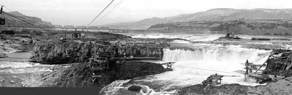
Panorama created by John Jengo using images from the Gerald W. Williams Collections, Special Collections & Archives Research Center, Oregon State University Libraries. Photos undated, but interpreted by others to be circa 1954.
Historical photographs showing the numerous elevation drops of falls and rapids of Celilo Falls on the Columbia River (river flow is from right to left). Clark’s observation of high water flood marks that could be “plainly trac’d around the falls” were probably noted along the cliffs (center) just downstream of the main falls (right).
Mt. Hood and Long Narrows
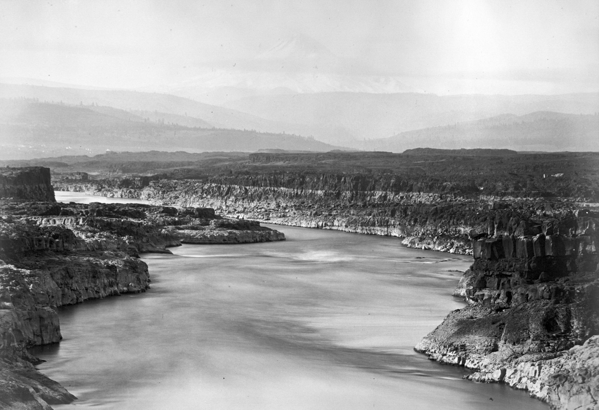
Carleton E. Watkins, 1882.
Deschutes River
Over four days (22 October 1805–25 October 1805) the expedition would be navigating through one of the most exciting and difficult stretches of the entire water route to the Pacific, raging torrents compressed through narrow slots of bedrock with several sets of daunting falls and pitches. Several outstanding geological features were noted on October 22, 1805 such as “a large Island of high, uneaven [rocks], jutting over the water”[2]Another island feature described by Clark on this day, “a high dry rich Island of about 400 yards wide and 800 yards long” at the mouth of the Deschutes River, was footnoted as being … Continue reading at the mouth of the Deschutes River. This is now Miller Island, still visible today as a large outcropping of the Frenchman Springs Member of the Wanapum Basalt,[3]See Columbia River Basalts. and evidently isolated by Missoula floodwaters from comparable member rocks on the north bank of the river. And there was “a verry Considerable rapid,” formerly the Deschutes Rapids, now drowned, where Clark “beheld an emence body of water Compressd in a narrow Chanel of about 200 yds in width, fomeing over rocks maney of which presented their tops above the water.” That formidable rapid was a harbinger of the exceedingly convoluted river course to come.
Celilo Falls
The corps first encountered what they called the Great Falls of the Columbia, subsequently known as Celilo Falls (and referred to as such hereafter), in the late afternoon of 22 October 1805, near today’s Wishram, Washington, where Clark noted:
the waters is divided into Several narrow chanels which pass through a hard black rock forming Islands of rocks at this Stage of the water.[4]The expedition’s route through Celilo Falls and the Short and Long Narrows is dominated by the Frenchman Springs Member of the Wanapum Basalt, but intricate faulting in this area has also … Continue reading
The expedition passed through the falls the following day, via portage, paddling, and cording the canoes over “a pitch of 8 feet in which the chanel is divided by 2 large rocks.” The next day, Clark would detail more specifically the route through Celilo Falls, while astutely noting evidence of a much higher water level:
[24 October 1805:] The first pitch of this falls is 20 feet perpendicular, then passing thro’ a narrow Chanel for 1 mile to a rapid of about 18 feet fall below which the water had no perceptable fall but verry rapid . . . . It may be proper here to remark that from Some obstruction below, the cause of which we have not yet learned, the water in high fluds (which are in the Spring) rise <nearly> below these falls nearly to a leavel with the water above the falls; the marks of which can be plainly trac’d around the falls.
Short Narrows
The expedition did not have to travel far to find out which “obstruction” was causing the back-flooding at Celilo Falls: the daunting “narrow chanel” of the Short Narrows whose width (45 yards) was particularly noteworthy:
[24 October 1805:] at this place the water of this great river is compressed into a Chanel between two rocks not exceeding forty five yards wide and continues for a 1/4 of a mile when it again widens to 200 yards and continues this width for about 2 miles when it is again intersepted by rocks. This obstruction in the river accounts for the water in high floods riseing to Such a hite at the last falls. The whole of the Current of this great river must at all Stages pass thro’ this narrow chanel of 45 yards wide. —Clark
Or as Patrick Gass would explain in his 23 October 1805, journal entry, with perhaps some welcomed clarity contributed by his editor David McKeehan: “The reason of this rise in the water below the falls is, that for three miles down, the river is so confined by rocks (being not more that [than] 70 yards wide) that it cannot discharge the water, as fast as it comes over the falls.” Thus, the expedition journal keepers were describing a seasonal flow occurrence here at the Short Narrows that was a microcosm of the Missoula back-flooding phenomenon during the massive floods thousands of years earlier at Wallula Gap.
Measuring the High Water Mark
Clark does not divulge a relative height of the “marks of which can be plainly trac’d around the falls,” stating only that these spring floods rise “nearly to a leavel with the water above the falls.” In order to ascertain what that flooding height might have been, we can refer to the journals of Patrick Gass, John Ordway, and Joseph Whitehouse to learn the height of the falls— 37 feet, eight inches. However, it is presumed herein that these journal keepers were referring to the whole mile-long Celilo Falls complex because Gass stated “the whole height [emphasis added] of the falls is 37 feet, 8 inches”[5]Moulton, ed., Journals, 10:160. and Ordway stated “the hight of the particular falls in all [emphasis added] is 37 feet eight Inches.”[6]Moulton (ed.), Journals, 9:244. Only by assuming these journal keepers were referring to the whole mile-long falls complex can the 20-foot height of the “first pitch of this falls,” as … Continue reading If this is correct, we can then surmise from the journals the expedition members observed a flooding level at the falls of about thirty-eight feet. However, both Patrick Gass and John Ordway mention a different and greater high water mark:
[23 October 1805:] The high water mark below the falls is 48 feet, and above only 10 feet four inches from the surface of the water: so that in high water there is nothing but a rapid, and the salmon can pass up without difficulty. —Gass
[25 October 1805:] the River between these narrows and the great falls rises at high water 48 feet perpenticular by its being confined by the different narrows. —Ordway[7]Moulton, ed., Journals, 9:245.
Reconciling this forty-eight-foot measurement with Clark’s statement that high water rises “nearly to a leavel” with the water above the thirty-seven-foot, eight-inch Celilo Falls complex is possible if we speculate that this forty-eight-foot estimation of flood height was measured farther downriver and therefore included an elevation drop of the river between the foot of the Celilo Falls and The Short and Long Narrows.
Long Narrows
Having successfully negotiated the Short Narrows, Clark prudently scouted the protracted obstacle of the Long Narrows on the evening of 24 October in preparation for running the rapids the next day:
[24 October 1805:] walked down three miles to examine the river Over a bed of rocks, which the water at verry high fluds passes over…The evening being late I could not examine the river to my Satisfaction, the Chanel is narrow and compressed for about 2 miles, when it widens into a deep bason to the Stard. Side.
[25 October 1805:] This Chanel is through a hard rough black rock, from 50-100 yards wide. Swelling and boiling in a most tremendious maner.
There is a lot of revealing information in Clark’s brief description. He astutely noted the bench he was walking on, elevated from the low water flow of the Columbia River, would become inundated at higher flows. In terms of the channel’s rather restricted width, later explorers and surveyors would describe the Long Narrows as essentially a “mill race”[8]Although there are several excellent mid-nineteenth century descriptive narratives of Celilo Falls and the Short and Long Narrows by explorer John Charles Frémont, Henry Abbot of the U.S. Corps of … Continue reading because it ran nearly straight and true, almost canal-like in its consistent alignment. Clark’s observation of the “deep bason” that is present-day Spearfish Lake (formerly Big Eddy) indicates he may have taken a sounding; if so, he would have found holes some 120 feet deep, which at this locale would measure about 90 feet below present-day sea level. This has suggested to geologists that entrenched channels like the Long Narrows may have been excised by the Missoula floods,[9]O’Connor and Waitt, “Beyond the Channeled Scabland—Part 2,” 57:4, 77. It is also possible that post-glacial age river flows carved the channel-bottom topography, perhaps aided by … Continue reading albeit on a smaller scale than most of the canyons and coulees in the Channeled Scablands.
Now Inundated
Not only are the Celilo Falls and the Short and Long Narrows rapids a distant memory because of the completion of The Dalles Dam in 1957, the rocks the captains observed at close range scouting the rapids, careening through them, and portaging around them are also submerged. We are left with brief riveting narratives, which began with William Clark‘s vivid firsthand impressions. Unfortunately, the very few comments recorded by Meriwether Lewis of the Narrows and Great Falls, such as when he noted “the long narrows are much more formidable than they were when we decended them last fall there would be no possibility of passind either up or down them in any vessel” lack his usual flair for descriptive detail.[10]Moulton, ed., Journals. 7:136. This is the point on the return journey where the expedition began to abandon the river and procure horses for the journey east, although Patrick Gass and several other … Continue reading We have serviceable descriptions of the geology by later explorers and surveyors, the most articulate of which were written by men who were eagerly seeking ways to defeat the falls and rapids with canals and dynamite. And then there are the evocative black and white photographs taken in the first half of the twentieth century, which provide the proof of the ferocious beauty, intricacy, and scale of the rapids, falls, and channels that have been inundated.


Celilo Falls Portage is a High Potential Historic Site along the Lewis and Clark National Historic Trail managed by the U.S. National Park Service. On-site access is restricted, but nearby Celilo Park provides public viewing and interpretation of the area from the Oregon side of the river.—ed.
Notes
| ↑1 | John W. Jengo, “After the Deluge: Flood Basalts, Glacial Torrents, and Lewis and Clark’s “Swelling, boiling & whorling” River Route to the Pacific,” Part 1, We Proceeded On, August 2014, Volume 40, No. 3, the quarterly journal of the Lewis and Clark Trail Heritage Foundation. The original, full-length article is provided at lewisandclark.org/wpo/pdf/vol40no3.pdf#page=9. |
|---|---|
| ↑2 | Another island feature described by Clark on this day, “a high dry rich Island of about 400 yards wide and 800 yards long” at the mouth of the Deschutes River, was footnoted as being Miller Island (see Moulton, ed., Journals, 5:326, n. 8), but I believe this was actually another geomorphic feature, perhaps a sand or gravel bar. An Elkskin-bound Journal sketch map (Moulton, ed., Journals, 5:316, fig. 21) illustrates a distinctly linear feature and it is clearly distinguishable from the larger Miller Island. |
| ↑3 | See Columbia River Basalts. |
| ↑4 | The expedition’s route through Celilo Falls and the Short and Long Narrows is dominated by the Frenchman Springs Member of the Wanapum Basalt, but intricate faulting in this area has also exposed the Priest Rapids Member of the Wanapum Basalt and the older Grande Ronde Basalt. |
| ↑5 | Moulton, ed., Journals, 10:160. |
| ↑6 | Moulton (ed.), Journals, 9:244. Only by assuming these journal keepers were referring to the whole mile-long falls complex can the 20-foot height of the “first pitch of this falls,” as noted by Clark on 24 October 1805, be reconciled with these 37 foot, 8 inches measurements. |
| ↑7 | Moulton, ed., Journals, 9:245. |
| ↑8 | Although there are several excellent mid-nineteenth century descriptive narratives of Celilo Falls and the Short and Long Narrows by explorer John Charles Frémont, Henry Abbot of the U.S. Corps of Topographic Engineers, and others, the most useful to me from a geological perspective from the first 100 years after Lewis and Clark are the Annual Reports of the War Department, which include this superb description of the “mill race” that was the Long Narrows at low water: “Here, for the distance of about 9,000 feet, the total low-water discharge of the Columbia is forced between high banks of solid rock nearly vertical and in some places not over 160 feet apart, the low-water surface having a fall of 11.2 feet in this distance. The banks are solid basalt rock, precipitous, and from 40 to 60 feet high, and the bottom is a succession of pockets 40 to 60 feet deep.” See Captain William W. Harts, “Survey of Columbia River Between the Foot of The Dalles Rapids and the Head of Celilo Falls, Oregon and Washington, with a View to the Construction of Canals and Locks, in Annual Reports of the War Department for the Fiscal Year Ended June 30, 1901, Report of the Chief of Engineers (Washington, D.C.: Government Printing Office, 1901), Part 5, Appendix VV 16, 3509. |
| ↑9 | O’Connor and Waitt, “Beyond the Channeled Scabland—Part 2,” 57:4, 77. It is also possible that post-glacial age river flows carved the channel-bottom topography, perhaps aided by steeper river gradients during the time that sea levels were lower than today. |
| ↑10 | Moulton, ed., Journals. 7:136. This is the point on the return journey where the expedition began to abandon the river and procure horses for the journey east, although Patrick Gass and several other men would continue upriver in two canoes until they passed the John Day River and rejoined the main party on the evening of 23 April 1806. |