Taming Rocky Rivers
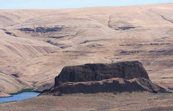
Monumental (Ship) Rock
© John W. Jengo. Used by permission.
Although the captains’ geological remarks were sparse along the Snake and Columbia Plateau portion of the Columbia River, they noted several unique geomorphic landmarks still visible today. These include Monumental Rock, an outcropping of the Lower Monumental Member of the Saddle Mountains Basalt that was called “Ship Rock” by William Clark.
When retracing the expedition’s route down the Snake and Columbia Rivers today, observers must reconcile themselves with the disappointing prospect of not seeing most of the dramatic river-centric features that filled the expedition journals:
13 October 1805: bad rapids, rocks in every derection. —Clark
The expedition’s three hundred-mile river route from today’s Lewiston, Idaho, to Bonneville Dam has been drowned by a total of eight federally-owned hydroelectric dams, including four dams on the lower Snake River, each about a hundred feet high and impounding from twenty-eight to thirty-nine miles of the river.[2]The dams on the Snake River, moving downstream from the confluence with the Clearwater River, are Lower Granite (completed in 1975, 100-foot high with a 39.3-mile long impoundment), Little Goose … Continue reading The Snake River dams were constructed relatively recently (1961-1975) in the waning days of the dam-building fever that swept across the West. These four Snake River dams are now prime targets for removal in the next few decades to restore migratory fish passage, particularly for salmonid species, which could greatly enhance the restoration of their spawning runs up into the Clearwater and Salmon Rivers.[3]In this author’s opinion, there are ample renewable energy and efficiency options to replace the modest amount of power generated by these dams and their limited use for barge traffic. The most … Continue reading
Dubbed “Ship Rock”
Monumental Rock from the River
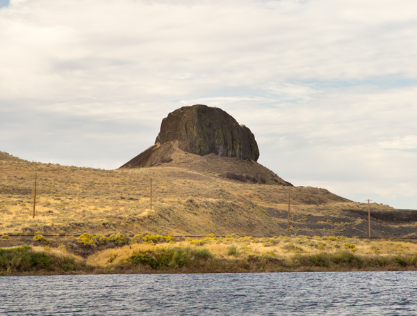
© 4 October 2014 by Kristopher K. Townsend. Permission to use granted under the Creative Commons Attribution-Share Alike 4.0 International license.
From the water, Monumental Rock resembles the prow of a large ship coming straight towards your boat. —Kristopher Townsend, ed.
Although it is not possible to directly observe the rocks around which the expedition maneuvered in the rapids, there are several large-scale geologic features that sit above the dam impoundments:
14 October 1805: at 2. miles passed a remarkable rock verry large and resembling the hill [hull] of a Ship Situated on a Lard point at Some distance from the assending Countrey. —Clark
Dubbed “Ship Rock” on Clark’s route map,[4]Moulton, ed., Journals, 1(Atlas): Map 74. but now known as Monumental Rock, this distinct outcropping of the Lower Monumental Member[5]Geologists have grouped lithologically comparable rock units into formations and individual lava flows closely spaced in time into formation members as a way to organize the bewildering number of … Continue reading of the Saddle Mountains Basalt[6]See Columbia River Basalts. is located on the south bank of the Snake River in Walla Walla County, Washington, just upriver of Lower Monumental Dam. Like the recorded comments on Hat Rock on the Columbia River passed by the expedition on 19 October 1805, this description is a fine example of the captains’ minimalist, but still informative, geological remarks. They were diligent in selecting unique geomorphic landmarks that enable us to precisely pinpoint important waypoints along their trek.
Additional Geomorphic Landmarks
Editor’s Note: In addition to Monumental Rock, other uniquely shaped rocks still serve as geomorphic landmarks. The following are described on this site:
Notes
| ↑1 | John W. Jengo, “After the Deluge: Flood Basalts, Glacial Torrents, and Lewis and Clark’s “Swelling, boiling & whorling” River Route to the Pacific,” We Proceeded On, August 2014, Volume 40, No. 3, the quarterly journal of the Lewis and Clark Trail Heritage Foundation. The original, full-length article is provided at https://lewisandclark.org/wpo/pdf/vol40no3.pdf#page=9. |
|---|---|
| ↑2 | The dams on the Snake River, moving downstream from the confluence with the Clearwater River, are Lower Granite (completed in 1975, 100-foot high with a 39.3-mile long impoundment), Little Goose (completed in 1970, 98-foot high with a 37.2-mile long impoundment), Lower Monumental (completed in 1969, 100-foot high with a 28.1-mile long impoundment), and Ice Harbor (completed in 1961, 100-foot high with a 32-mile long impoundment). |
| ↑3 | In this author’s opinion, there are ample renewable energy and efficiency options to replace the modest amount of power generated by these dams and their limited use for barge traffic. The most biologically assured way to benefit all Columbia River Basin salmon and steelhead stocks now listed under the Endangered Species Act would be to remove these insurmountable obstacles to upriver migration, which would also eliminate the high mortality rate of fish returning downriver, curtail further losses of genetic diversity caused by hatchery fish interbreeding, and replace the warm, stagnant reservoirs with a more oxygenated, free-flowing river habitat. For the economically-minded, dam removal would end the spending of billions of dollars on ineffective fish recovery, transport, and hatchery efforts, and restore/create thousands of fishery-related and river-based recreational jobs. |
| ↑4 | Moulton, ed., Journals, 1(Atlas): Map 74. |
| ↑5 | Geologists have grouped lithologically comparable rock units into formations and individual lava flows closely spaced in time into formation members as a way to organize the bewildering number of lava beds into some semblance of order. |
| ↑6 | See Columbia River Basalts. |