Geomorphic Features
Cliffs at Horse Heaven Hills
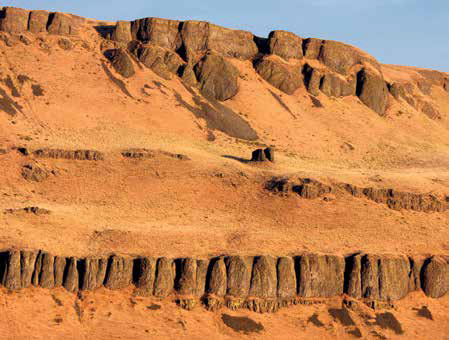
© John Jengo. Used by permission.
Sunrise on the Horse Heaven Hills at Wallula Gap, passed by the expedition on 8 October 1805, and described by William Clark as a “range of high Countrey.” The cliffs, comprised of the Frenchman Springs Member of the Wanapum Basalt capped by various flows of the Saddle Mountain Basalt, were scoured multiple times by Glacial Lake Missoula outburst floods.
Over two days starting 19 October 1805, Clark would dutifully note significant geomorphic features along the expedition route, most famously the stovepipe hat-shaped outcropping of Hat Rock (shaped by Missoula floods) near present-day Cold Springs, Oregon. Clark also observed on October 19 the “knob” that is Sillusi Butte, a distinctive outcropping of the Umatilla and Pomona members of the Saddle Mountain Basalt just downriver of the present-day McNary Dam.[2]See Columbia River Basalts. The next day, Clark noted the “high countrey . . . on the Stard. Side” that is Alder Ridge, another Saddle Mountain Basalt exposure that was aptly described by Lewis on 25 April 1806, as “the river hills are about 250 feet high and generally abrupt and craggey in many places faced with a perpendicular and solid rock. this rock is black and hard.”[3]Moulton, ed., Journals, 7:166. The Elephant Mountain Member of the Saddle Mountain Basalt is prominently exposed along Alder Ridge. It’s tempting to interpret Lewis’s use of the word … Continue reading Most river-centric features worthy of note in the journals are now completely submerged by both McNary and John Day Dams (all the rapids and most of the islands, although the tops of a few islands can be seen in the Blalock Islands area).
Cliffs at John Day
Basalt Cliff at John Day
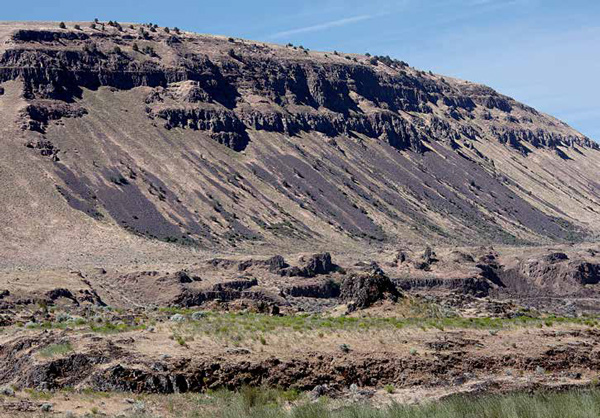
© John Jengo. Used by permission.
View of Wanapum Basalt cliffs and rock falls on the south bank of the Columbia River just over a mile east of the John Day River, a feature described by William Clark on 21 October 1805, as “emence piles of rocks appears as if Sliped from the Clifts under which they lay.” The rough, hackly Grande Ronde Basalt rocks in the foreground, on a terrace well above the present-day channel of the Columbia River, were intensely abraded and scoured by turbulent Lake Missoula floodwaters.
About halfway through the 21 October 1805, traverse, Clark commented:
on the Lard. Side emence piles of rocks appears as if Sliped from the Clifts under which they lay.
It can be a challenge to precisely locate some of Lewis and Clark’s geologic notations that were not landmark-specific. The 21 October 1805, rock fall observation is rather general, but is likely referring to mass-wasting features along a fourteen-mile long stretch of dramatically steep slopes visible today between Blalock Canyon and the John Day River on the Oregon side. Along this route, one can observe multiple alluvial fans, talus slopes and landslides that have careened down from the basalt cliffs of Wanapum Basalt.[4]The cliffs are primarily the Frenchman Springs Member capped by the Priest Rapids Member, with some indication of the Roza Member along the slopes in the westernmost section nearer the John Day River. Some of these erosional features have been vegetated, having the appearance of enormous sand dunes blanketing the base of the cliffs, while other rock falls appear much younger, comprised of unweathered angular rocks splayed out in overlapping fan-shaped arrays.[5]There is a greater incidence of fresh rock slides along the westernmost five-mile stretch of cliffs from just west of I-84 mile marker 120 to the John Day River. Like many other fresh mass-wasting features along this reach of the Columbia River, they likely post-date the last of the major Missoula floods, because those flooding episodes would have scoured the cliff slopes clean of debris.[6]Connor and Waitt, “Beyond the Channeled Scabland—Part 2,” Oregon Geology, 57:4 (July 1995): 77. In fact, O’Connor and Waitt suggest numerous Columbia River and tributary valley … Continue reading
Indian Rapids
The Columbia River was at about its lowest level of the year on 21 October 1805. That day, the Corps encountered six rapids of somewhat varying difficulty. They stopped to examine each one before entering it—”as was our custom,” Clark explained, “and at all that was very dangerous” they put all the non-swimmers ashore to walk around. The fifth obstacle, he continued, was “a verry bad rapid, thro which we found much dificuelty in passing, the river is Crouded with rocks in every Direction.” That was the long rough place later called Indian Rapids, which bracketed the mouth of the stream they named “River La Page,” after the man who had enlisted at Fort Mandan to replace the cashiered Private John Newman; it was later renamed for John Day, a member of the Astor Expedition’s overland party (1811-12) who got lost in this part of today’s Oregon. Thankfully, the Corps of Discovery floated through all six rapids without incident.
This view of Indian Rapids, taken before the end of the 19th century, suggests it was comparatively benign, at least from a distance. Just around the bend and a day away, however, awaited the infamous Long and Short Narrows and the Cascades of the Columbia, together the most dangerous stretch of the Columbia they would encounter. Indian Rapids have been submerged beneath the waters of Lake Umatilla, the reservoir behind John Day Dam, since the dam’s completion in 1971.
—Joseph Mussulman
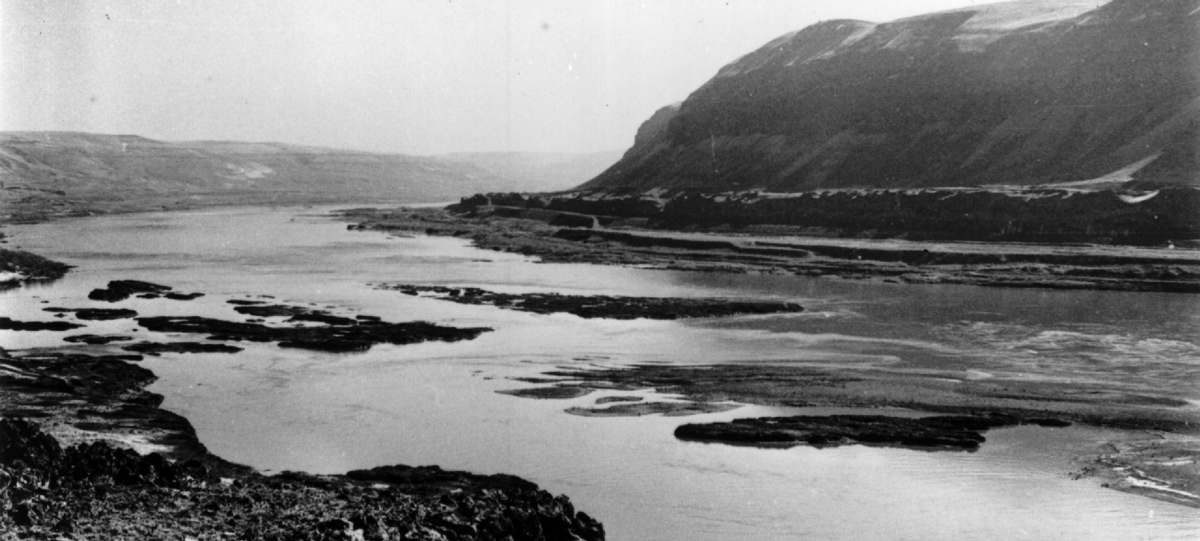
Oregon Historical Society, #92212.
Notes
| ↑1 | John W. Jengo, “After the Deluge: Flood Basalts, Glacial Torrents, and Lewis and Clark’s “Swelling, boiling & whorling” River Route to the Pacific,” Part 1, We Proceeded On, August 2014, Volume 40, No. 3, the quarterly journal of the Lewis and Clark Trail Heritage Foundation. The original, full-length article is provided at https://lewisandclark.org/wpo/pdf/vol40no3.pdf#page=9. |
|---|---|
| ↑2 | See Columbia River Basalts. |
| ↑3 | Moulton, ed., Journals, 7:166. The Elephant Mountain Member of the Saddle Mountain Basalt is prominently exposed along Alder Ridge. It’s tempting to interpret Lewis’s use of the word “perpendicular” as a hint of recognition of columnar basalts, but he was probably just describing vertical cliff faces. |
| ↑4 | The cliffs are primarily the Frenchman Springs Member capped by the Priest Rapids Member, with some indication of the Roza Member along the slopes in the westernmost section nearer the John Day River. |
| ↑5 | There is a greater incidence of fresh rock slides along the westernmost five-mile stretch of cliffs from just west of I-84 mile marker 120 to the John Day River. |
| ↑6 | Connor and Waitt, “Beyond the Channeled Scabland—Part 2,” Oregon Geology, 57:4 (July 1995): 77. In fact, O’Connor and Waitt suggest numerous Columbia River and tributary valley landslides may have been triggered by the floods because rock strata were undercut of their supporting foundation by flood inundation and scouring. |