[30 October 1805:] The rocks project into the river in maney places and have the appearance of haveing fallen from the highe hills. —Clark[2]Gary E. Moulton, ed., The Journals of the Lewis & Clark Expedition, 13 volumes (Lincoln, Nebraska: University of Nebraska Press, 1983-2001), 5:354.
Columbia River Basalt Group
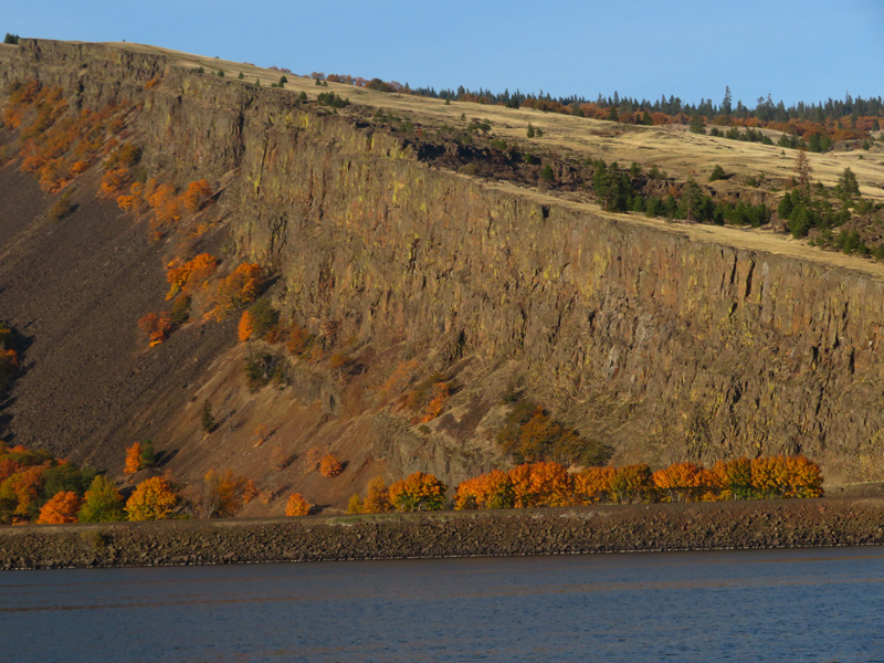
Coyote Rock Anticline
© 2019 by Robert Heacock. Used by permission.
Above: View of a natural cross-section of Columbia Hills anticline comprised primarily of Grande Ronde Basalt on the north side of the Columbia River. It was the uplift of the High Cascades that exposed these and other basalt formations to the relentless incision and entrenchment of the Columbia River, which created the magnificent Gorge that William Clark described as having mountains “high on each Side.”
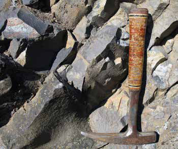
Grande Ronde Basalts, Mitchell Point
© John W. Jengo. Used by permission.
A representative outcrop at Mitchell Point of the Grande Ronde Basalt, a silica-rich, fine-grained rock lacking large and conspicuous crystals, which composes the majority of the “dark coloured rocks” observed by the Lewis and Clark expedition in the Columbia River Gorge. Grande Ronde Basalts, depicted here with their characteristic range of black to medium gray to more weathered rusty coloration, were deposited during the peak of Columbia River flood basalt eruptions between 16 and 15.6 million years ago. The outcrop scale is indicated by the one-foot long rock hammer.
The passage through the Columbia River Gorge by the Lewis and Clark expedition between 28 October and 3 November 1805, was as geologically noteworthy as any seven-day period experienced by the Corps of Volunteers for North Western Discovery. Their roughly sixty-seven-mile transit from The Dalles to the Sandy River bore fresh evidence of gigantic landslides, drowned forests, and disruptive volcanic eruptions.
After a much needed respite from the arduous passage through Celilo Falls and the Long and Short Narrows of The Dalles, the expedition pushed off from Rock Fort on the morning of October 28, 1805, and began their entrance into the Columbia River Gorge.
[28 October 1805:] we proceeded on river inclosed on each Side in high Clifts of about 90 feet of loose dark coloured rocks. —Clark
Those familiar “dark coloured rocks” belong to the Columbia River Basalt Group (CRBG).[3]See Columbia River Basalts. Most of the lava flows in the Gorge are Grande Ronde Basalts deposited during the peak of Columbia River flood basalt eruptions between 16 and 15.6 million years ago. Although the Gorge presents dramatic exposures of the CRBG, it actually has fewer individual lava flows than the upriver terrain the expedition had just passed through.[4]Although the CRBG has been estimated to be greater than 13,000 feet thick in the Pasco Basin area, it is only some 4,000 feet thick in the Gorge per Jim E. O’Connor and Scott F. Burns, … Continue reading
Having traveled only about five miles on 28 October, it would be on 29 October 1805, that Clark took note of the dramatic topographical changes (and the increase in botanical diversity) of the Gorge as the expedition entered the present-day area of Rowena Gap:
we proceeded on, the mountains are high on each Side, containing Scattering pine white oake & under groth, hill Sides Steep and rockey.
Glacial Lake Missoula Floods
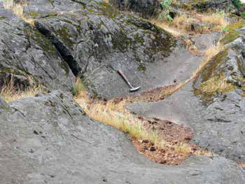
Smooth, Grooved Basals
© John W. Jengo. Used by permission.
An outcrop of smooth, grooved basalt that was vigorously scoured out and polished by episodes of Glacial Lake Missoula flood waters, located over 300 feet above sea level in the garden of the historic Columbia River Gorge Hotel. Although compelling evidence of the height and power of the raging flood waters that helped widen the Columbia River Gorge and possibly trigger landslides, the Gorge was not created by the episodic Missoula floods. The outcrop scale is indicated by the one-foot long rock hammer.
The Columbia River Gorge was not formed by the Glacial Lake Missoula floods (as is sometimes erroneously claimed in travel guide literature[5]http://www.frommers.com/destinations/oregons-columbia-gorge/ 627619#sthash.G1MYQMWQ.dpbs. Accessed 16 September 2015.), although the superb view of the lower cliff sections of the Columbia Hills anticline at Rowena Gap were certainly accentuated and reshaped by flood scouring. The consolidated rocks that compose the Gorge were formed by a complex interplay of CRBG flood basalt deposition and basin subsidence, along with contemporaneous folding and faulting. At the same time the CRBG flows were occurring in the middle and late stages of the Miocene Epoch,[6]The Miocene Epoch was 23 to 5.3 million years ago; the CRBG flows commenced about 16.7 million years ago. the region was experiencing intense compression stresses.[7]This compression was originally thought to have been largely caused by very complex subduction-related stresses between the North American Plate and various tectonic plates off the coast of the … Continue reading Shortly after lava flows were emplaced, this unceasing compression transformed the original, slightly uneven layer-cake arrangement of the flows into mile-scale folds akin to rucks or ripples in a carpet. This geomorphology of ridge-forming narrow anticlines separated by valley-forming broad synclines can be observed throughout the Columbia Plateau.[8]The structural subprovince exemplified by N70°E-trending anticlinal ridges and synclinal valleys is called the Yakima Fold Belt. The width of the anticlines and synclines are quite asymmetrical, … Continue reading
The combination of contemporaneous basalt deposition and deformation are responsible for the warped geological structure that can be observed in certain places in the Gorge, such as the Columbia Hills at Rowena Gap. However, this region would have remained an expansive, nondescript plain with a handful of low-relief ridges if not for the regional-scale uplift caused by the rising High Cascades that brought the Gorge into being. Beginning some three million years ago,[9]The author has come across different age estimates for the beginning of the regional uplift so a median age was chosen for the main text of the article. Two million years is estimated on page 476 in … Continue reading the central axis of the High Cascades commenced rising over 3,000 feet upward,[10]O’Connor and Burns, “Cataclysms and Controversy,” 238. exposing the CRBG to the relentless incision and entrenchment of the Columbia River, which created the magnificent Gorge that William Clark described as having mountains “high on each Side.”
The Scouring of Memaloose Island
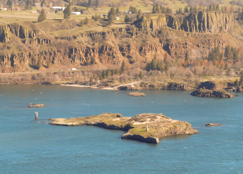
Memaloose Island (view north)
© 2022 by Robert Heacock. Used by permission.
Dutifully mapping the Columbia River on 29 October 1805, Clark noted:
passed three large rocks in The river the middle rock is large long and has Several Squar vaults on it. we call this rockey Island the Sepulchar.
Lewis, who apparently only kept a journal on the return journey through the Gorge, reported on their brief foray exploring the island:
[15 April 1806:] we halted a few minutes at the sepulchre rock, and examined the deposits of the ded at that place . . . there were thirteen sepulchres on this rock which stands near the center of the river and has a surface of about 2 acres above high-water mark.
This nearly bare, roughly flat-topped mass of Wanapum Basalt[11]The bedrock geology of Memaloose Island appears not to have been officially published by either the Oregon Department of Geology and Mineral Industries (DOGAMI) or the United States Geological Survey … Continue reading is known as Memaloose Island, and its stripped surface indicates it bore the full brunt of Missoula flood scouring. It became one of the many islands in the Columbia river used as a Native American burial ground, which Lewis and Clark appear to have treated with due respect (i.e., there is no indication in the journals that any “deposits of the ded” were removed by the Corps of Discovery). Unfortunately, this was not an example emulated by later settlers, who performed their own scouring of remains and artifacts until the extant native remains were removed prior to the partial inundation of the island by the Bonneville Dam impoundment.
Notes
| ↑1 | John W. Jengo, “After the Deluge: Flood Basalts, Glacial Torrents, and Lewis and Clark’s “Swelling, boiling & whorling” River Route to the Pacific,” Part 2, We Proceeded On, November 2015, Volume 41, No. 4, the quarterly journal of the Lewis and Clark Trail Heritage Foundation. The original, full-length article is provided at https://lewisandclark.org/wpo/pdf/vol41no4.pdf#page=10. |
|---|---|
| ↑2 | Gary E. Moulton, ed., The Journals of the Lewis & Clark Expedition, 13 volumes (Lincoln, Nebraska: University of Nebraska Press, 1983-2001), 5:354. |
| ↑3 | See Columbia River Basalts. |
| ↑4 | Although the CRBG has been estimated to be greater than 13,000 feet thick in the Pasco Basin area, it is only some 4,000 feet thick in the Gorge per Jim E. O’Connor and Scott F. Burns, “Cataclysms and Controversy—Aspects of the Geomorphology of the Columbia River Gorge,” in Jim E. O’Connor, Rebecca J. Dorsey, and Ian P. Madin, eds., Volcanoes to Vineyards: Geologic Field Trips through the Dynamic Landscape of the Pacific Northwest: Geological Society of America Field Guide 15 (Boulder, CO: Geological Society of America, 2009), 237-251. This is because only a subset of about 31 out of the 350+ continental flood basalt flows discharging from linear fissures systems located in eastern Oregon, eastern Washington State, and western Idaho reached this far westward. For an accounting of which flows reached the western Columbia River Gorge, including at least 26 different Grande Ronde Basalts flows, see page 740 in Ray E. Wells, Alan R. Niem, Russell C. Evarts, and Jonathan T. Hagstrum, “The Columbia River Basalt Group—From the Gorge to the Sea,” in O’Connor, et al. Volcanoes to Vineyards, 737-774. |
| ↑5 | http://www.frommers.com/destinations/oregons-columbia-gorge/ 627619#sthash.G1MYQMWQ.dpbs. Accessed 16 September 2015. |
| ↑6 | The Miocene Epoch was 23 to 5.3 million years ago; the CRBG flows commenced about 16.7 million years ago. |
| ↑7 | This compression was originally thought to have been largely caused by very complex subduction-related stresses between the North American Plate and various tectonic plates off the coast of the Pacific Northwest (hence the movement of the plates has been termed “plate tectonics”). Although that is the mechanism for the continuation of folding to the present day, it has now been proposed that the spreading mantle plume that sourced the lava flows also caused the subsidence and folding of basalt deposits in those areas overlying the plume fringes, leading researchers to conclude “that deformation and volcanism of the Columbia River Basalt Group are closely linked.” See Stephen P. Reidel, Victor E. Camp, Terry L. Tolan, John D. Kauffman, and Dean L. Garwood, “Tectonic Evolution of the Columbia River Flood Basalt Province,” in Reidel, et al. Columbia River Flood Basalt, 293-324. |
| ↑8 | The structural subprovince exemplified by N70°E-trending anticlinal ridges and synclinal valleys is called the Yakima Fold Belt. The width of the anticlines and synclines are quite asymmetrical, with the narrow anticlinal ridges being 0.5 to 3.1 miles wide and with the broad synclinal valleys from 10 to over 30 miles wide. See page 27 in Terry L. Tolan, Marvin H. Beeson, and Kevin A. Lindsey, “The Effects of Volcanism and Tectonism on the Evolution of the Columbia River System: A Field Guide to Selected Localities in the Southwestern Columbia Plateau and Columbia River Gorge of Washington and Oregon State, 28-29 September 2002,” Northwest Geological Society—Society Field Trips in Pacific Northwest Geology, 1-74. |
| ↑9 | The author has come across different age estimates for the beginning of the regional uplift so a median age was chosen for the main text of the article. Two million years is estimated on page 476 in Terry L. Tolan and Martin H. Beeson, “Intracanyon Flows of the Columbia River Basalt Group in the Lower Columba River Gorge and their Relationship to the Troutdale Formation,” Geological Society of America Bulletin, 95:4 (April 1984), 463-477 and on page 95 in Terry L. Tolan, Marvin H. Beeson, and Beverly F. Vogt, “Exploring the Neogene History of the Columbia River: Discussion and Geologic Field Trip Guide to the Columbia River Gorge – Part I Discussion,” Oregon Geology, 46:8 (August 1984), 87-97. A more recent census of ancestral Columbia River Gorge research has the uplift occurring as early as 4 million years ago; see page 225 in Stephen P. Reidel and Terry L. Tolan, “The Late Cenozoic Evolution of the Columbia River System in the Columbia River Flood Basalt Province,” in Reidel, et al. Columbia River Flood Basalt, 201-230. |
| ↑10 | O’Connor and Burns, “Cataclysms and Controversy,” 238. |
| ↑11 | The bedrock geology of Memaloose Island appears not to have been officially published by either the Oregon Department of Geology and Mineral Industries (DOGAMI) or the United States Geological Survey (USGS), nor is the geology depicted on the geologic map of the Hood River Quadrangle (compiled by Michael A. Korosec, Geologic Map of the Hood River Quadrangle, Washington and Oregon, Washington Division of Geology and Earth Resources Open File Report 87-6, 1987, 1 plate, scale 1:100,000, 1-40). The author had surmised that the island is comprised of one or more members of the Wanapum Basalt, most probably the Frenchman Springs and/or Roza Members. James Anderson from the University of Hawaii at Hilo and Ken Lite of the Oregon Department of Water Resources have tentatively mapped the island as the Roza Member, but are endeavoring to verify that interpretation (Personal Communication, Kenneth E. Lite, 10 December 2014). |
Experience the Lewis and Clark Trail
The Lewis and Clark Trail Experience—our sister site at lewisandclark.travel—connects the world to people and places on the Lewis and Clark Trail.
![]()
Discover More
- The Lewis and Clark Expedition: Day by Day by Gary E. Moulton (University of Nebraska Press, 2018). The story in prose, 14 May 1804–23 September 1806.
- The Lewis and Clark Journals: An American Epic of Discovery (abridged) by Gary E. Moulton (University of Nebraska Press, 2003). Selected journal excerpts, 14 May 1804–23 September 1806.
- The Lewis and Clark Journals. by Gary E. Moulton (University of Nebraska Press, 1983–2001). The complete story in 13 volumes.
This site is provided as a public service by the
![]()
Lewis and Clark Trail Alliance
with additional funding from the following:

