Tongue Point (view upriver)
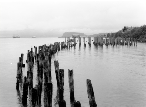
© 1999 Greg MacGregor.
Beyond the aged, weather-beaten pilings that supported one of the Columbia River’s many large salmon canneries a century or more ago, looms the profile of Tongue Point, 7 km (4.5 mi) distant. To its left (north), two ocean freighters follow the deep, narrow shipping channel toward distant inland seaports. The small city of Astoria, Oregon, which in 1847 boasted the first post office west of the Rocky Mountains, is out of the photo to the right.
During World War II a naval air station was established there; after the base was decommissioned the facilities were occupied by a federal Job Corps center.
Dredging and rip-rapping (bank reinforcement) have widened the isthmus to a quarter of a mile at its narrowest. The deepest part of the Columbia River estuary, called the Tongue Point Channel, is near the north shore at Pillar Rock, and near the south shore from Tongue Point to the Columbia Bar. That channel is narrow, but periodic dredging keeps it open so that ocean-going vessels can dock as far inland as Portland, 100 miles from the river’s mouth. At mean tide the channel is more than 14 fathoms (84 feet) deep near Tongue Point. The rest of the lower estuary, which is about six miles wide where the Corps crossed it, is only from two to six fathoms (12 to 36 feet) in depth.
On 25 November 1805, the Corps canoed up the north side of the Columbia to the vicinity of Pillar Rock, which is about a half mile southwest of today’s village of Altoona, Washington. The rock is now marked by a beacon as a guide to river traffic. The following day they crossed to the south side among the “low marshey Islands” that now comprise the Lewis and Clark National Wildlife Refuge. On 27 November 1805 they continued to thread their way among the many small islands and around “a verry remarkable point” which extended out into the estuary for a mile and a half. It was about four miles around, said Clark, and was joined to the mainland by an isthmus no more than fifty yards wide. He named it Point William.
Actually, it already had two names. Local Indians called it Secomeetsiuc, but in October 1792, 13 years before Lewis and Clark arrived, explorer George Vancouver, captain of the British sloop Discovery, sent Lieutenant William Broughton across the bar in a small boat to explore the lower Columbia. Broughton gave it the name by which it is still known today, Tongue Point.
Pinned Down by Weather
As the Corps rounded Tongue Point the wind rose hard from the west, and heavy seas with torrential rain forced them back to the east shore of the narrow isthmus, where they huddled for ten miserable days. “The Sea which is imedeately in front,” Clark wrote on 1 December 1805:
roars like a repeeted roling thunder and have rored in that way ever Since our arrival in its borders which is now 24 Days Since we arrived in Sight of the Great Western Ocian, I cant Say Pasific as Since I have Seen it, it has been the reverse.
Not only were they pinned down by the weather, but also they found the woods on the mainland to the south to be impenetrable. Their leather clothing and their tents were rotting and falling apart from being continually wet. It was hard enough to keep fires going in the wind and rain, and if they tried to get any benefit from them, the smoke drove them back.
Hunger made the discomforts harder to bear. Some of the men, including Clark, were ill from eating pounded salmon boiled in seawater. At last, on 2 December 1805, six miles from camp, Joe Field shot the first elk to be bagged west of the Rockies. He saw two other elk herds, but it was raining so hard he couldn’t keep his powder dry, and so couldn’t fire his gun. Geese and ducks were plentiful, but they were “too wild to be killed,” which Clark attributed to the Indians’ pursuit of them.
The following day they ate the marrow from the thigh bones of the elk, after which Sacagawea chopped up the bones and boiled out a pint of grease that Clark found “Superior to the tallow of the animal.”
On 5 December 1805 Lewis returned with “verry Satisfactory information to all the party.” He had found a good place for their winter encampment, and his own party had killed 6 elk and 5 deer on their way back to Point William.
Last Encounter
The Corps’ last encounter with Tongue Point was shorter and pleasanter than the first. On 23 March 1806, they left Fort Clatsop at 1:00 p.m. By 2:45 they had crossed Meriwether’s (Young’s) Bay and “commenced coasting[1]In this instance, “coasting” means to stay in the shallow water near the seacoast—or in this case the Columbia’s shore, where the river’s current is slower and occasional … Continue reading the difficult shore.” At 5:30, Lewis recorded, “we doubled [sailed around] point William, and at 7 arrived in the mouth of a small creek where we found our hunters.” It was a good start on a homeward journey that would last 185 days.


Tongue Point is a High Potential Historic Site along the Lewis and Clark National Historic Trail managed by the U.S. National Park Service. The site can be viewed from the east at the Lewis and Clark National Wildlife Refuge and to the west along the Astoria Riverwalk.—ed.
Notes
| ↑1 | In this instance, “coasting” means to stay in the shallow water near the seacoast—or in this case the Columbia’s shore, where the river’s current is slower and occasional eddies will ease upstream progress. Coasting upriver in the Columbia’s estuary would require close observance of tides and winds, as well as river currents, in order to avoid submerged hazards in shallow water, and to keep from losing forward momentum by being caught in faster currents that may sweep in close to shore. The pilot experienced in coasting will also pay close attention to changes in the topography and the qualities of the ground ashore. Admiral W. H. Smyth, The Sailor’s Word-Book (London: Blackie and Son, 1867), s.v. “coasting.” |
|---|