Ocean in View?
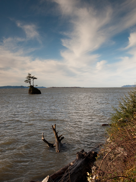
Columbia River Estuary (View west)
© 19 December 2010 by Kristopher K. Townsend.
Above: a brief break between winter storms shows the Columbia River Estuary between Altoona and Grays Bay. Pillar Rock is about two miles behind the photographer.
The exploration of the north bank of the Columbia River estuary from the Cascades to the Coast is one of the most dramatic and varied episodes in the entire story of the Lewis and Clark Expedition. In fact, it deserves to be read word by word in each of the journalists’ renditions. For our purposes, however, a brief overview will suffice.
The entire party was elated when the fog lifted on the morning of 7 November 1805. They fancied they could already see and hear the Pacific Ocean, although it was still more than 20 miles away, well beyond their horizon.[1]At water level—assuming the improbable, a dead-calm estuary—the earth’s curvature would have placed the visible horizon only 3.1 miles from their point of observation. However, the high … Continue reading Clark was exultant. “Great joy in camp we are in View of the Ocian, this great Pacific Octean which we have been So long anxious to See. . . . and the roreing or noise made by the waves brakeing on the rockey Shores (as I Suppose) may be heard distictly.”
Clark’s famous exclamation was another instance of the captains’ habit of reacting prematurely to presumed evidence of passionately wished-for objectives. Remember their excitement upon first seeing what they took to be the Rocky Mountains, which actually were still out of sight, miles and weeks away. (The unfamiliar geography of the Mountain West had duped them.) Share their “secret pleasure” on 26 May 1805 at finding themselves “so near the head of the heretofore conceived boundless Missouri,” which they would never reach, and which was not to be pinpointed until 1888. We know that Lewis was mistaken when, on 12 August 1805, he triumphantly announced he had drunk from “the most distant fountain” of the great river,[2]The spring that is the true and remotest source of the Missouri River was located in September 1895 by Lillian Culver, wife of Willliam N. Culver, who was the partner of the American surveyor Jacob … Continue reading yet we can’t help but feel his excitement. Think of their emotional odyssey through the several—more than the four they expected—Rocky Mountain gates, and their high expectations in late August 1805 when they were confident that their can-do spirit would carry them down the Salmon River despite the Indians’ assurances that it was impassable. Consider that they fancied they could recognize the rise of tidewater at the foot of Beacon Rock even though, more than a hundred miles from the ocean, it was barely measurable.
Who among us can forget those moments when time surged beyond the balance-point and our hearts leaned toward what we desired most, even though it was still a long time before we’d “get to grandma’s house.” But despite the excitement that momentarily overrode the whole company’s frustration with the dismal days and the rough water, Clark soon got his own feelings under control. In his remarks under the Courses and Distances for that day he reconsidered his initial heart-bent exclamation and calmly wrote, with emphasis: “we are in view of the opening of the Ocian, which Creates great joy.”
Heavy Seas
Swells surging up the estuary rolled and tossed the canoes so much that several of the Corps became seasick. So did Sacagawea. A few unregenerate landlubbers were desperate enough from thirst to drink the salty river water, and thereby made small down payments on self-destruction. Their dugout canoes, with a mere four to six inches of freeboard, were ill-suited for seafaring. Even modern, light-weight small craft are no match for the unpredictability of conditions on the Columbia’s estuary. As the locals say, “Nobody plays on the Columbia.”
The combination of heavy seas and southwest winds kept them close to the north shore where gigantic driftwood logs were fearsome hazards. Their campsite on the narrow strand was awash at high tide. All the party were wet through and through, day and night and their leather clothing was falling to pieces, which worsened their misery. And hungry. Pounded fish was the only item on the menu. They were pinned down for five days on the east side of Point Ellice—which they appropriately named “Point Distress,” “Point Dismal,” and “Stormy Point.” It was typical November weather on the Northwest coast.
Indians dogged their trail, chatting, smoking, staring, harassing, sometimes stealing.[3]At least the Americans considered it theft. The Indians, who were the gatekeepers and traders at the mouth of the Columbia River, were just collecting the tolls due them. In Tourist Country today … Continue reading Selling salmon and roots, and proving their experience at driving hard bargains. Amazing the scruffy white strangers with their skill in their graceful, buoyant canoes. Piloting them among the maze of marshy islands (today’s Lewis and Clark Wildlife Refuge). Bringing their fleas, and leaving a few for the torment of those American tourists. But notwithstanding the hunger, cold, wind, and rain, and the hazards of both sea and shore, the party were yet “chearfull and anxious to See further into the Ocian.”
Notes
| ↑1 | At water level—assuming the improbable, a dead-calm estuary—the earth’s curvature would have placed the visible horizon only 3.1 miles from their point of observation. However, the high lands north of the river’s mouth reach 1,400 feet above Mean Sea Level; their summits would have come into view nearly 65 miles upriver. Those to the south rise nearly 1,000 feet above MSL; they would have been visible from somewhat less than 50 statute miles away. |
|---|---|
| ↑2 | The spring that is the true and remotest source of the Missouri River was located in September 1895 by Lillian Culver, wife of Willliam N. Culver, who was the partner of the American surveyor Jacob V. Brower (1844-1905). It issues from the 8,800-foot level (MSL) on the north face of 10,210-foot (3112 m) Mount Jefferson in the Centennial Range—which supports the Continental Divide and the boundary between Montana and Idaho west of Yellowstone National Park. Culver Springs (located at 33°37’43″N; 111°37’38″W) waters the farthest perennial source of the Red Rock River, which becomes the Beaverhead at the exit of Clark Canyon Reservoir. The Beaverhead becomes the Jefferson River at the town of Twin Bridges, Montana, and joins the Madison and Gallatin Rivers at the Three Forks of the Missouri. Jacob Culver’s name is no longer on the map, but the highest, first lake in the Culver Canyon drainage is named for Mrs. Culver. Today, Lillian Lake is listed in the Geographic Names Information System (GNIS) as the official source of the Missouri River. For a narrative of the Brower-Culver expedition, see Jacob. V. Brower, The Missouri River and Its Utmost Source (St. Paul, Minnesota: [Pioneer Press], 1897). |
| ↑3 | At least the Americans considered it theft. The Indians, who were the gatekeepers and traders at the mouth of the Columbia River, were just collecting the tolls due them. In Tourist Country today it’s called a “bed tax.” |