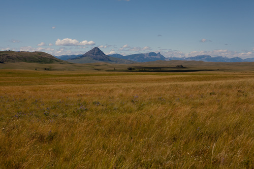
Haystack Butte: Lewis’s View
© 20 July 2011 by Kristopher Townsend. Permission to use granted under the Creative Commons Attribution-Share Alike 4.0 International license.
This view of the landmark Lewis identified as Shishequaw Mountain was taken from approximately the point where he may have first caught sight of it.
Awakening to a clear frosty dawn after their first night back in U.S. territory since late the preceding August 1805, Lewis and his party of eleven men hit the trail at 6:00 a.m. on a course North 25° West (335° True North). In about an hour they crested a hill from which, Lewis reported, “we saw the Shishequaw mountain about 8 ms. distant imediately before us.” He described it as “a high insulated [isolated] conic mountain standing several miles in advance of the Eastern range of the rocky mountains.”
Perhaps obedient to instructions given him by the Nez Perce guides who had escorted the party across the Bitterroots, he and his men immediately left the road that kept near the mountains and proceeded for a considerable distance through the “extencive leavel and butifull bottom,” before striking the 20-yard-wide stream he named Shishequaw Creek (today called Elk Creek). After dining at that point they paralleled the creek for 2 more miles to its confluence with the Sun River,[1]The explorers also learned that the Hidatsas called it Mah-pah-pah, ah-zhah, and the Nez Perce Cal la mar-Sha mosh. (Moulton, 3:367-68, 7:343.) Clark concluded (June 20, 1805) from Hidatsa … Continue reading which they followed for another 8 miles to a large island where they camped for the night, having covered, at a brisk Meriwether-Lewis-pace, 28½ miles that day.
Lewis’s instant recognition of this landmark and road sign by name, as if he knew exactly what to look for, is exceptional insofar as he gave no clue as to where, when, or from whom he had learned of it. Shishequaw was Lewis’s phonetic spelling of shishiquoi, a French Canadian transliteration of zheesheegwun, which was an Algonkian noun meaning rattle. A shishiquoi could be conical in shape (see photo above), which may account for the Indian name of the mountain.[2]Lewis & Clark Lexicon of Discovery (Pullman, Washington: WSU Press, 2004), 160. We are indebted to the author of that book, Alan H. Hartley, for calling attention to the etymology and definition … Continue reading
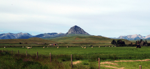
Modern Grazing
Haystack Butte
© 2005 J. Agee.
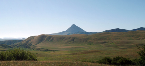
This photo was taken from the vicinity of the Old North Trail at a point approximately 5 miles northwest of Shishequaw Mountain. Lewis and his party did not see it from this angle. The summit of Shishiquaw Mountain reaches 6,712 feet above mean sea level, or approximately 2,000 feet above the average elevation of the high prairie which spreads out for many miles to the east.
In his paraphrase of the Lewis and Clark journals (1814), Nicholas Biddle included Lewis’s brief description of this landmark, but more than likely the first settlers—cattle ranchers—who arrived in the upper Sun River Valley in the 1870s weren’t aware of that, and never heard it called Shishequaw. They had no need to use the Old North Trail and thus would not have seen it often from the north or south.
After thousands of head of cattle died of starvation in the deep snows of 1886-87, the tradition of open-range grazing came to a sudden end. Ranchers prudently fenced their land to confine their herds where they could be fed whenever necessary.[3]Philp, 2:276-77, 281-83, 289-91, 298-99. From 1890 on, hayfields and haystacks proliferated in river valleys throughout the West, changing this ancient landmark’s visual significance. Just when the name first appeared on a map is not known, but Elliott Coues referred to it in his 1893 annotation of Biddle’s paraphrase of the journals.[4]Elliott Coues, History of the Lewis and Clark Expedition by Meriwether Lewis and William Clark, Reprint (New York: Dover, 1893), 3:1079n. Coues noted that on the Stevens Railroad Survey map of 1856 … Continue reading
Haystacks are seldom seen in the Sun River Valley today. In this photograph, faintly discernible next to a red barn at left of center, is a stack of common square bales weighing approximately 75 pounds each. Several persons are needed to load them, one at a time, onto a wagon, then unload and untie them at the feeding site. In the nearer hayfield are many large round bales that are five feet in diameter and five feet long. They weigh at least 1,200 pounds each, but are more economical for a large operation than square bales, as they can easily be moved by one person operating a specially equipped tractor. Hay was not mechanically baled until the end of the 19th century. Instead, it was stacked loose in high piles in a fenced feedlot where cattle could be driven to eat directly from the haystack.
The French word butte was not in the English dictionaries of Lewis and Clark’s time.[5]There are three instances in the journals, two fairly clear, the other somewhat questionable. Lewis, in the list of mineralogical specimens sent back from Fort Mandan, wrote that the second item was … Continue reading In the early 1840s, however, explorer John Frémont found that in the West, butte was broadly applied to “detached hills and ridges which rise abruptly, and reach too high to be called hills or ridges, and not high enough to be called mountains.”[6]Charles C. Frémont (1813-1890), Report of the Exploring Expedition to the Rocky Mountains in the Year 1842, and to Oregon and North California in the Years 1842-’44 (Washington, D.C.: … Continue reading
Another Indian Name
Shishequaw Mountain Seen from the North
© 2005 J. Agee.
This photo was taken from the vicinity of the Old North Trail at a point approximately 5 miles northwest of Shishequaw Mountain. Lewis and his party did not see it from this angle. The summit of Shishiquaw Mountain reaches 6,712 feet above mean sea level, or approximately 2,000 feet above the average elevation of the high prairie which spreads out for many miles to the east.
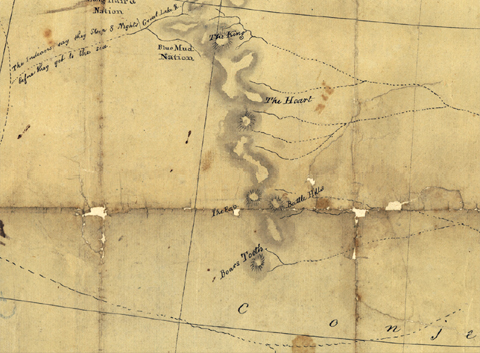
Another Indian name for the eminence Lewis knew as Shishequaw Mountain was Is se cut to yis, or “The Pap”—that is, nipple.[7]Theodore Binnema, “Old Swan, Big Man, and the Siksika Bands, 1794-1815,” Canadian Historical Review, Vol. 77, No. 1 (March 1996), 22-24. In 1801 a Siksika (Blackfeet) Indian named Ac ko mok ki (Old Swan), drew a map of the Rocky Mountains for Peter Fidler, a Hudson’s Bay Company surveyor and trader, and highlighted the five landmarks shown above on the Rocky Mountain Front near the Old North Trail. “The King” is now called Chief Mountain, and is a prominent feature in Glacier National Park; “The Heart” is Heart Butte, south of the town of Browning on the Blackfeet Indian Reservation; the “Battle Hills” are Square Butte (Lewis and Clark’s “Fort Mountain”), Shaw Butte and Crown Butte (shown much too far north of their actual location); The Bears Tooth,” still known by that name, towers above the place Lewis named “the gates of the rocky mountains,” today’s Gates of the Mountains northeast of Helena.
The noted British cartographer Aaron Arrowsmith (1750-1823) incorporated Fidler’s information in his 1802 map of “New Discoveries of Interior Parts of North America,” a copy of which Jefferson provided to Meriwether Lewis. Arrowsmith’s map was the major source drawn upon by the American cartographer and surveyor Nicholas King (1771-1812), for the composite map he created on orders from Secretary of the Treasury Albert Gallatin expressly for the expedition.[8]Donald Jackson, ed., Letters of the Lewis and Clark Expedition, with Related Documents, 1783-1854 (2nd ed., 2 vols., Urbana: University of Illinois Press, 1978). It is not known for certain whether … Continue reading It is remarkable, considering the chain of information involved, and the different standards of measurement—Indian days of travel (“sleeps”) versus Euro-American leagues and miles—that The Pap is shown so close to its actual location—approximately two degrees of longitude too far west, but less than one degree of latitude too far north.[9]One degree of latitude equals about 69 statute miles; a degree of longitude at this latitude equals roughly 47.25 statute miles.
Clark’s Maps
Detail from Nicholas King’s Map, 1803
To see labels, point to the map.
Library of Congress.
Clark’s Map
Lewis’s Route (detail)
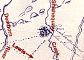
Lewis must have told Clark that from this perspective the road appeared to lead directly to it, which may account for the dotted line Clark drew from the point where Lewis said he left the Indian road and headed toward the Sun River. The road undoubtedly went around the mountain on one side or the other, for it would have been a segment of the Old North Trail, a loose network of well worn north-south travel routes that more or less paralleled the Rocky Mountain Front and extended all the way to Mexico. They had been worn into the earth by the feet of millions of aboriginal travelers over a period of perhaps 15,000 years.[10]Walter McClintock, The Old North Trail; or, Life, Legends and Religion of the Blackfeet Indians (Lincoln: University of Nebraska Press, 1910), 434-40; Peter Stark, “The Old North Trail,” … Continue reading
At Fort Mandan during the winter of 1804-05 the captains had time to study the maps they had brought with them, and reconcile them with information freely given by friends such as the Mandan chief, Sheheke (Big White) (see Clark’s Fort Mandan Maps). The result of this work was a new map by Clark that summarized what they expected to encounter, and where, when they set out westward on April 7, 1805. Clark showed and labeled The King, The Heart, and Battle Hills. He located the river they would name for Secretary of War Dearborn in about the right place. He labeled an extensive stream “The River which scolds at all other rivers,” which later would prove to be two separate drainages, the Marias and the Sun. Two forks of it bracket “The Tooth,” which could have been yet another name for Shishequaw Mountain, although it is more likely he confused it with “The Bears Tooth,” which he omitted. There was a lot yet to be learned.
On the map that accompanied Nicholas Biddle’s paraphrase (1814) of Lewis and Clark’s journals, Shishequaw Mountain is shown but not named; Shishequaw River is drawn (unnamed) as the Sun River tributary now called Elk Creek, with its source southwest of the butte instead of northwest, as it was in Clark’s first draft of Lewis’s route (See Mapping Lewis’s Shortcut).
Credits: Alan H. Hartley, linguistics, Detroit, Michigan; Robert N. Bergantino, geologist, Western Montana School of Mines and Geology; Marilyn Hudson, Curator, Three Tribes Museum, Newtown, North Dakota; Jack Lepley, manager, Museum of the Northern Great Plains, Fort Benton, Montana; David Alt, Professor Emeritus, Geology Department, The University of Montana, Missoula.
Notes
| ↑1 | The explorers also learned that the Hidatsas called it Mah-pah-pah, ah-zhah, and the Nez Perce Cal la mar-Sha mosh. (Moulton, 3:367-68, 7:343.) Clark concluded (June 20, 1805) from Hidatsa information that the Medicine River took its name from the “unaccountable rumbling Sound” often heard in its vicinity, “which like all unacountable thing[s] with the Indians of the Missouri is Called Medicine.” See Unaccountable ‘Artillery’ of the Rockies. |
|---|---|
| ↑2 | Lewis & Clark Lexicon of Discovery (Pullman, Washington: WSU Press, 2004), 160. We are indebted to the author of that book, Alan H. Hartley, for calling attention to the etymology and definition of shishequaw. Elijah Harry Criswell, in Lewis and Clark: Linguistic Pioneers, University of Missouri Studies, vol. 15, no. 2 (Columbia: University of Missouri Press, 1940), either overlooked or ignored the word. It occurs in the journals of various travelers in Canada, including the elder Alexander Henry (1763), Alexander Mackenzie (1801), and Daniel Harmon (1820). |
| ↑3 | Philp, 2:276-77, 281-83, 289-91, 298-99. |
| ↑4 | Elliott Coues, History of the Lewis and Clark Expedition by Meriwether Lewis and William Clark, Reprint (New York: Dover, 1893), 3:1079n. Coues noted that on the Stevens Railroad Survey map of 1856 Haystack Butte was misnamed “Heart Mountain.” Furthermore, Old Swan’s “The Heart” (presently Heart Butte), which is approximately 60 miles northwest of Haystack Butte, is absent from the Stevens map. It is somewhat difficult to account for the confusion, since Stevens had Biddle’s paraphrase of the journals with him, and the description of Lewis’s route—which Stevens himself retraced in part—is clear enough to be helpful today. Nevertheless, Stevens’s error continued to be copied onto every new map, effectively standing in the way of anyone trying to locate Shishequaw Mountain, much less understand its meaning, until Coues reported that “Heart mountain of Stevens’ large map” was “now [in 1893] known as Haystack Butte.” |
| ↑5 | There are three instances in the journals, two fairly clear, the other somewhat questionable. Lewis, in the list of mineralogical specimens sent back from Fort Mandan, wrote that the second item was “Found just above the entrance of the cannon Ball river, the butt[e] is principally composed of this sand.” (Moulton, 3:473). The second occurrence is in Whitehouse’s journal entry for July 28, 1804: “we Came to a hi CLift or Buut one hun[dred] feet.” The third may be in a remark by Clark on May 22, 1805, in which Thwaites (II, 1:61) omitted an ampersand and interpolated two emendations: “I walked out after dinner and assended a but[te] a few miles [off] to view the countrey.” Moulton transcribes the sentence verbatim: “I walked out after dinner and assended & but a few miles to view the Countrey,” implying that with the ampersand Clark merely started to write something else but changed his mind and wrote that he only “walked out” a few miles. In view of the word’s history, and the absence of any other uses of butte by the journalists, even in references to Fort Mountain (Square Butte), the latter reading is preferable. Reuben Gold Thwaites, Original Journals of the Lewis and Clark Expedition, 1804-1806, 8 vols. (New York: Dodd, Mead, 1904-1905). |
| ↑6 | Charles C. Frémont (1813-1890), Report of the Exploring Expedition to the Rocky Mountains in the Year 1842, and to Oregon and North California in the Years 1842-’44 (Washington, D.C.: Gales and Season, 1845), 145. Or, as an essayist in the Century Illustrated Monthly Magazine in 1882 (Vol. 24, p. 510) wrote, rolling his eyes between parentheses, “(Everything in the way of hill, rock, mountain, or clay-heap is called a butte in Montana.)” Some modern definitions specify that buttes have flat tops rimmed by steep escarpments that slope toward the surrounding plain. (For a classic illustration see Square Butte.) However, geologists’ current usage is broader than that, closer to Frémont’s and the original French: “rising ground; knoll, mound, or hillock.” See Alan H. Hartley, Lewis & Clark Lexicon of Discovery (Pullman: Washington State University Press, 2004), 30-31. |
| ↑7 | Theodore Binnema, “Old Swan, Big Man, and the Siksika Bands, 1794-1815,” Canadian Historical Review, Vol. 77, No. 1 (March 1996), 22-24. |
| ↑8 | Donald Jackson, ed., Letters of the Lewis and Clark Expedition, with Related Documents, 1783-1854 (2nd ed., 2 vols., Urbana: University of Illinois Press, 1978). It is not known for certain whether the captains received the map before the expedition left camp on Wood River on May 14, 1804. This issue is discussed in John Logan Allen, Lewis and Clark and the Image of the American Northwest (New York: Dover, 1975), 97-98. |
| ↑9 | One degree of latitude equals about 69 statute miles; a degree of longitude at this latitude equals roughly 47.25 statute miles. |
| ↑10 | Walter McClintock, The Old North Trail; or, Life, Legends and Religion of the Blackfeet Indians (Lincoln: University of Nebraska Press, 1910), 434-40; Peter Stark, “The Old North Trail,” Smithsonian, Vol. 28, No. 4 (1997), 56-66; Marcella Sherfy, “The Old North Trail: America’s Earliest Highway, Heritage Education (Spring 2004), 12-17. James Alexander Philp, “An Historical Geography of the Sun River Watershed, Montana,” Ph. D. dissertation, Geography, 3 vols., The University of Montana, 1997; 2:197-208, 226-28. |
Experience the Lewis and Clark Trail
The Lewis and Clark Trail Experience—our sister site at lewisandclark.travel—connects the world to people and places on the Lewis and Clark Trail.
![]()
This page was funded in part by a grant from the Montana Cultural Trust.
Discover More
- The Lewis and Clark Expedition: Day by Day by Gary E. Moulton (University of Nebraska Press, 2018). The story in prose, 14 May 1804–23 September 1806.
- The Lewis and Clark Journals: An American Epic of Discovery (abridged) by Gary E. Moulton (University of Nebraska Press, 2003). Selected journal excerpts, 14 May 1804–23 September 1806.
- The Lewis and Clark Journals. by Gary E. Moulton (University of Nebraska Press, 1983–2001). The complete story in 13 volumes.
This site is provided as a public service by the
![]()
Lewis and Clark Trail Alliance
with additional funding from the following:

