With the acquisition of horses, Native Nations crossing the Rocky Mountains to hunt for bison became more common. Two of their trails are used by the captains—in separate groups—to return to the bison-rich plains.
After crossing the Bitterroot Mountains on what is known today as the Lolo Trail, the expedition divides forces at Travelers’ Rest. Lewis takes one group east and north up the Blackfoot River and then over Lewis and Clark Pass. They return to their old camp above the Great Falls of the Missouri to retrieve supplies and specimens cached there.
From Travelers’ Rest, Clark goes up the Bitterroot River and crosses the Continental Divide at present Gibbons Pass. They cross the Big Hole Valley and return to Fortunate Camp where they had cached tobacco, food, and most of the canoes.
At the Headwaters of the Missouri, Sgt. Ordway‘s detachment paddles the canoes down the Missouri destined for the portage of the Great Falls. Clark’s group–along with all the horses—travel up the Gallatin River valley on their way to the Yellowstone River.
The Palouses
by Kristopher K. Townsend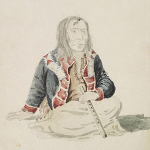
At the time of the Lewis and Clark Expedition, the Palouses had coalesced around four primary villages on the lower Snake River: Penewawa, Almota, Wawaiwai, and Palus. Lewis and Clark estimated their population as 2,300 which included Northern Nez Perce.
The Nez Perce
by Kristopher K. Townsend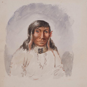
First encountered September 1805 when John Colter met them on Lolo Creek near Travelers’ Rest, they would remain with the expedition in one way or another until 25 October 1805 saying their goodbyes at Rock Fort at The Dalles of the Columbia River. They were together again between 23 April 1806 and 4 July 1806, the expedition’s longest period of contact with any Native American Nation.
The Blackfeet
by Kristopher K. Townsend
They commonly called themselves saokí•tap•ksi meaning ‘prairie people.’ The meaning ‘people with black feet’ comes from exonymns—the names given by other, external tribes. Historically, several related groups comprise the Blackfoot or Blackfeet people.
The Northern Nez Perce Trail
Traces of the ancient trail
by Steve F. Russell![]()
Imagine a time when all travel was on foot. This ancient time was the beginning of travel across the rugged Bitterroot Mountains for the Indian tribes of the northwest United States. This is a story of travel in those mountains from ancient times up to the present.
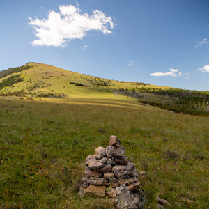
Haystack Butte
Known as Shishequaw Mountain
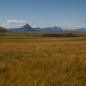
Today’s iconic Haystack Butte was a landmark already known to Lewis and Clark as Shishequaw Mountain. Seeing it from Lewis and Clark Pass, 7 July 1806, provided Lewis with a reference point on Nicholas King’s 1803 map.
Mapping the Road to the Buffalo
Clark's interpretation of Lewis's shortcut
by Joseph A. Mussulman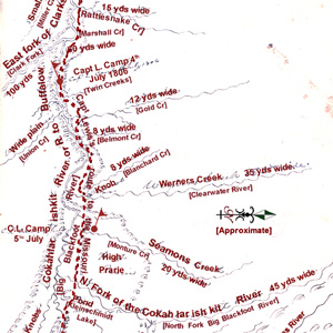
Clark produced this map of Lewis’s route sometime after the Corps was reunited on 12 August 1806, near today’s New Town, North Dakota.
Synopsis Part 5
Fort Clatsop to St. Louis
by Harry W. Fritz
On 23 March 1806, once again battling the rising spring runoff, as it had each of the two previous years on the Missouri, the Corps of Discovery started up the Columbia River towards home.
Rocky Point Views
One last view
They crossed over the peak without pausing for one last view of “those tremendious mountanes . . . in passing of which,” Clark would assert two days later, “we have experienced Cold and hunger of which I shall ever remember.”
Dividing Forces at Travelers’ Rest
Their daring tactical plan
by Joseph A. Mussulman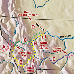
Dividing into as many as five separate details was part of a bold, diplomatic plan to achieve three of the objectives set by President Jefferson.
Passing Hell’s Gate
Up the Blackfoot River
by Joseph A. Mussulman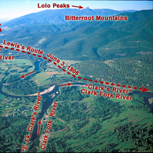
The continuation of the Northern Nez Perce Trail led from their camp at Travelers’ Rest to the plains near the Great Falls of the Missouri, saving hundreds of miles from the expedition’s 1805 route.
Crossing the Clark Fork
Lewis's rafting adventure
by Joseph A. Mussulman
With every crossing they unavoidably drifted farther downstream. Lewis recounted the climactic rafting episode of the day.
Seaman’s Creek
Clues to his name
by Joseph A. Mussulman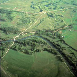
Twenty-eight and one-half miles upriver from their camp of 4 July 1806 the Indian road crossed a stream Lewis named after William Werner. At mile 31, they camped near the mouth of a stream the captain named after his dog, Seaman.
Big Hole to Three Forks
Sacagawea points to home
by Joseph A. Mussulman
Sacagawea informed Clark that “she had been in this plain frequently and knew it well,” that the creek they were following was a branch of the Big Hole River, and that “when we assended the higher part of the plain we would discover a gap in the mountains”
The Blackfoot River
by Joseph A. Mussulman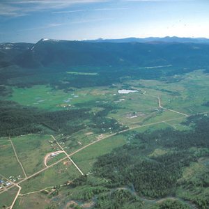
The road led Lewis and his men to the north of an “extensive high prarie rendered very uneven by a vast number of little hillucks and sinkholes.” Lewis noted: “These plains I called the prarie of the knobs.”
Lewis and Clark Pass
A shorter way
by Joseph A. Mussulman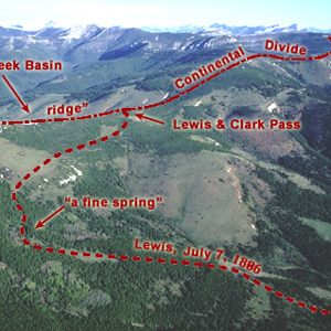
Sergeant Gass recorded that on 7 July 1806, Lewis’s detachment took a three-hour lunch break and then proceeded four miles, “when we came to the dividing ridge between the waters of the Missouri and Columbia.”
The Dearborn River Crossing
Along the Old North Trail
by Joseph A. Mussulman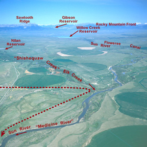
Shortly after crossing the Dearborn River, Lewis saw that the Indian road “continued along the foot of the mountain to the West of north” so he and his men cut northeast across the “tolerably level” plain toward the Sun River.
Down the Sun River
Through the "Battle Hills"
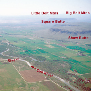
Meriwether Lewis has tempted fate and his “chapter of accidents” again by re-entering the domain of the people he had repeatedly been advised to steer clear of—the Blackfeet, Siksikas, Atsinas, and Assiniboines.
Return to the Portage
Lewis's hiatus
by Joseph A. Mussulman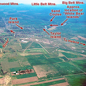
One can almost feel the thrill of wakening to a clear early-summer dawn at this powerful place on the pregnant plains where the Medicine meets the Missouri. Here began a five-day hiatus in Lewis’s master plan for his junket to find the boundary of British-held Canada.
Experience the Lewis and Clark Trail
The Lewis and Clark Trail Experience—our sister site at lewisandclark.travel—connects the world to people and places on the Lewis and Clark Trail.
![]()
Discover More
- The Lewis and Clark Expedition: Day by Day by Gary E. Moulton (University of Nebraska Press, 2018). The story in prose, 14 May 1804–23 September 1806.
- The Lewis and Clark Journals: An American Epic of Discovery (abridged) by Gary E. Moulton (University of Nebraska Press, 2003). Selected journal excerpts, 14 May 1804–23 September 1806.
- The Lewis and Clark Journals. by Gary E. Moulton (University of Nebraska Press, 1983–2001). The complete story in 13 volumes.
This site is provided as a public service by the
![]()
Lewis and Clark Trail Alliance
with additional funding from the following:

