Fort Clatsop’s Legacy?
Silas Smith’s Farmhouse
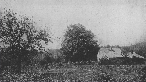
Photo by George M. Weister[?] for Olin D. Wheeler. See also Wheeler’s “Trail of Lewis and Clark”
Visitor Recollections
American history between the War of Independence and the War of 1812 is an empty period to most people today. But the Lewis and Clark expedition was big news back then, and westering Americans in the ensuing generations had good reason to remember at least some of the major places and events along the expedition’s route.
One of the first writers to devote special attention to the question of Fort Clatsop’s post-history was Olin D. Wheeler, who visited the site with Coboway’s grandson, Silas B. Smith, in 1900, and wrote briefly of it in his historical travelogue, The Trail of Lewis and Clark, 1804-1904.
Although Smith’s mother claimed her father’s people used the fort as a hunting camp for a decade or so, Gabriel Franchére, who arrived on the ship Tonquin with John Jacob Astor’s Pacific Fur Company in 1811, visited the site and saw only piles of rough, unhewn logs overgrown with vines. Seven years after the Corps left it, Alexander Henry, of the Hudson’s Bay Company, saw 25-foot trees growing among the ruins. In the early 1820s, the young ornithologist John Townsend, who accompanied Nathaniel Wyeth on his Columbia River expedition, found a couple of peace medals in the vicinity.
Beginning shortly before 1850 a succession of settlers cleared the land and set about farming, and later in the century logging and pottery businesses operated at or near the site. Meanwhile, a thin but resilient thread of personal attachment, legend, and reverence for its significance kept the hallowed place in mind for nearly a century.
The Oregon Historical Society acquired the site in 1901, erected a commemorative marker in 1912, and installed a bronze plaque there in 1928. The reconstruction visitors see now was built in 1955, and in 1958 the replica and some surrounding land was acquired by the National Park Service as a National Memorial. The first visitor center was built in 1963, and expanded into the present facility in 1991.
In an effort to reconcile the contradictions inherent in Fort Clatsop’s oral history, and to fix its precise location once and for all, archaeological studies were undertaken in 1948 and 1961, but were inconclusive. In 1996 a third exploration, employing the latest research technologies, was carried out but was similarly fruitless.
Silas Smith’s History
Neighborly Gift
The Corps of Discovery lived in Fort Clatsop from 25 December 1805 until 23 March 1806. On the day before their departure, the explorers left their “houses and furniture” to the Clatsop chief, Coboway, who had, Lewis wrote, “been much more kind an hospitable to us than any other indian in this neighbourhood.”
One wonders just how grateful Coboway could have been, for the Americans’ hastily-built structures were little more than rickety shacks compared with the sturdy, spacious plank houses he was accustomed to. And the Indians built theirs without benefit of steel axes or knives.
On 18 January 1806, Lewis wrote a 645-word description of a typical Indian house. A few highlights will suffice:
- The Clatsops Chinnooks &c construct their houses of timber altogether . . . they are from 14 to 20 feet wide and from 20 to 60 feet in length, and accommodate one or more families sometimes three or four . . . in the same room . . . .
- two or more posts of split timber . . . are sunk in the ground at one end and rise perpendicularly to the hight of 14 or 18 feet, the tops of them are hollowed in such a manner as to receive the ends of a round beam of timber which reaches from one to the other, most commonly the whole length of the building . . . .
- two other sets of posts and poles are now placed at proper distances on either side of the first . . . . these last rise to the intended hight of the eves, which is usually about 5 feet.
- smaller sticks of timber are now provided and are placed by pares in the form of rafters, resting on, and reaching from the lower to the upper horizontal beam, to both of which they are attatched at either end with the cedar bark . . . .
- the rough [roof] is then covered with a double range of thin boards, and an aperture of 2 by 3 feet left in the center of the roof to permit the smoke to pass.
- these houses are sometimes sunk to the debth of 4 or 5 feet in which cace the eve of the house comes nearly to the surface of the earth.
- in the center of each room a space of six by eight feet square is sunk about twelve inches lower than the floor having it’s sides secured with four sticks of squar timber, in this space they make their fire.
Clark added that they generally burned dry pine, split small, “which they perform with a piece of an Elks horn Sharpened at one end [d]rove into the wood with a Stone.”
Coboway’s good manners would have compelled him accept the gift gratefully, although in comparison with his own homes it may have been a white elephant.
In 1900 the house pictured was occupied by Franklin Shane, whose brother, Carlos Shane, had traveled west via the Oregon Trail and filed a claim on the site in 1848, clearing the land and starting his farm a short time later.
Olin D. Wheeler, author of the first illustrated guide to the route of the Lewis and Clark expedition,[1]Olin D. Wheeler, The Trail of Lewis and Clark 1804-1904. New York: G. P. Putnam’s Sons, 1904. was led here in 1899 by several persons, including three men with extensive knowledge of its history. One was Silas B. Smith, a grandson of the Clatsop leader Comowool—more correctly, Cóboway—to whom Lewis and Clark had given Fort Clatsop when they left in late March 1806. Another was George H. Himes, curator for the recently established (1898) Oregon Historical Society. A third was George M. Weister, a landscape photographer from Portland, Oregon.
Silas Smith wrote a brief history of the site expressly for Wheeler, who quoted it in part:
Concerning the expedition’s arrival at the Pacific in November 1805, and their sojourn at fort Clatsop the succeeding winter, as usual, more or less tradition was handed down by the Indians to their descendants, of the doings and characteristics of the people who had come among them.
At that time Cóboway . . . was the principal chief of the Clatsop tribe of Indians, within whose territory Fort Clatsop was established. Lewis and Clark erroneously gave the name of the chief as Comowool—that arose no doubt from the indistinct manner in which the Indians pronounced the name; according to their pronunciation the “b” in the name is but faintly sounded.
The chief had three daughters that arrived at womanhood, and all married white men for husbands. the eldest, Kilakotah, finally became Mrs. Louis Labontie, and the two were among the first settlers of the Willamette Valley,[2]The Willamette River, which Lewis and Clark heard Indians near Fort Clatsop call the Multnomah, had escaped their notice on the way down the Columbia, being hidden from their view by a large island. … Continue reading Labontie crossing the continent in 1811 with Wilson P. Hunt.[3]Wilson Price Hunt was the leader of the overland contingent of the Astor Fur Company, which deviated from Lewis and Clark’s route at the mouth of the Grand River, cut through the Big Horn … Continue reading
The second, Celiast, became Mrs. Solomon H. Smith. Her Christian name was Helen. with her husband they were among the earlier settlers in the Willamette, finally becoming the first agricultural settlers west of the Coast range of mountains, settling and opening up a farm on Clatsop Plains, Clatsop County, Ore., in August 1840. Her husband crossed the continent in 1832 with Captain Nathaniel Wyeth,[4]Nathaniel Jarvis Wyeth (1802-1856) was an explorer, naturalist, and fur trader who made two trips to the Northwest, in 1832 and 1834, leaving the Missouri River near Kansas City and following the … Continue reading and taught the first schools on the northwest coast, teaching at Fort Vancouver and in the Willamette country in 1833 and 1834.
The third daughter, Yaimast, became Mrs. Joseph Gervais. Gervais also came with Hunt in 1811, and was, I think, the first settler on the French prairie in the Willamette.
Cóboway’s descendants now live in four States—California, Oregon, Montana, and Canada—are too numerous to mention, and all are drifting away from his race.
My mother, Celiast Cóboway, the chief’s second daughter, lived until June 1891, and always maintained that she remembered the time of Lewis and Clark’s arrival, and also seeing the men. Mother said that in one of the houses they used was the large stump of a tree, which had been cut smooth, and which was used as a table. The tree had been cut down and then the house built, enclosing the stump.
The Indians here used to tell of the remarkable marksmanship of Captains Lewis and Clark with firearms, and of the surprises they used to give the savages by the wonderful accuracy of their shots.
An Indian youth, Twiltch by name, used to assist at fort Clatsop in the hunting of elk and other game, and was there taught the use of firearms, in the handling of which he became proficient. I knew him in his later years, and in my earlier acquaintance with him he stood at the head of the hunters of his tribe, and more particularly in the art of elk hunting. It was always his boast that he was taught the art by Lewis and Clark.
The Indians inhabiting the upper part of young’s river Valley and the upper Nehalem Valley were known as the Klatskanin people. It was claimed by Chief Cóboway that these people were disposed to attack the encampment at fort Clatsop, and it was only through his influence and constant dissuasion that they were restrained, and no violence committed.
Wheeler also quoted from the journal of Alexander Henry the Younger (d. 1814), a prominent Canadian fur trader and explorer who visited the site of Fort Clatsop in 1813. Henry found that the remains of the fort were still visible, although most of the structure had been cut up and carried off by the Indians. Moreover, Nature had begun its reclamation process: willow trees growing among the debris were already 25 feet high. Nevertheless, wrote Henry, “the situation is the most pleasant I have seen hereabouts, and by far the most eligible, both as to security from the Natives, and for hunting.”[5]Quoted in Wheeler, 2:198. The above photograph of the site of Fort Clatsop is at 2:195. Clearly, Lewis and his five companions, who in early December 1805 had spent six days searching for a place to winter over, had made a good choice.
Notes
| ↑1 | Olin D. Wheeler, The Trail of Lewis and Clark 1804-1904. New York: G. P. Putnam’s Sons, 1904. |
|---|---|
| ↑2 | The Willamette River, which Lewis and Clark heard Indians near Fort Clatsop call the Multnomah, had escaped their notice on the way down the Columbia, being hidden from their view by a large island. They missed it again on their way east in the spring of 1806, but asked directions of local Indians and quickly found it. On 2-3 April 1806, Clark explored the lower ten miles of the river with seven men and an Indian guide. |
| ↑3 | Wilson Price Hunt was the leader of the overland contingent of the Astor Fur Company, which deviated from Lewis and Clark’s route at the mouth of the Grand River, cut through the Big Horn Mountains and crossed Union Pass into the Green River Valley, proceeded north through today’s Grand Teton National Park, then followed the Snake River, genereally, to the Columbia, thence to the Columbia River, arriving at Fort Astoria—on 18 January 1812. Their whole journey is described and illustrated at http://www.thefurtrapper.com/wilson_hunt.htm. |
| ↑4 | Nathaniel Jarvis Wyeth (1802-1856) was an explorer, naturalist, and fur trader who made two trips to the Northwest, in 1832 and 1834, leaving the Missouri River near Kansas City and following the overland route which was soon to become known as the Oregon Trail. With him on the second trip were botanist Thomas Nuttall and ornithologist John Kirk Townsend. |
| ↑5 | Quoted in Wheeler, 2:198. The above photograph of the site of Fort Clatsop is at 2:195. |