After Lewis had completed his Marias River observations, the celestial data would need to interpreted to determine their location.
Detail from Clark’s Map of 1805
To see labels, point to the map.
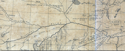
Library of Congress, Geography and Map Division, Washington, D.C.
Contrary to what the natives of the northern Great Plains might tell visitors, winter in these parts is not just a continuum of numbing cold, howling blizzards and drifting snow. Once or twice a month there comes a mild day. It begins like this: the sun, having peeped over the southeastern horizon about 8 a.m., climbs a gently sloping arc westward, reaching an altitude of about 20 degrees above the southern horizon by noon, all the while sweeping the blue-black shadows of leafless trees over wind-burnished snow. Meanwhile the temperature, which at sunrise may have been a brisk -10°F, slowly warms, and by early afternoon nears the freezing point—then, by early sunset, plummets back toward the season’s diurnal, sub-glacial level. Rigorous? Yes, but not nearly as rigorous as those winters during the early 1800s when a climatic period known as the Little Ice Age prevailed.
When the worst weather elements enveloped Fort Mandan in their frosty embrace during the winter of 1804-05, little could be done outdoors without risking frostbite or, if far from distinct landmarks, risking getting lost during a blizzard. On the other hand when those rare mild days prevailed, Lewis and Clark either visited their Mandan and Hidatsa neighbors or invited them into Fort Mandan. During these meetings the captains gathered information about the topography, the climate and the people along their intended route. This information which would help minimize the unexpected (at least as far as geography was concerned)—came from those who had traveled where Lewis and Clark hoped to go or had gathered said information from others who had been there. It would be the captains’ task to evaluate this second- and third-hand information for themselves as they traveled and correct it where necessary. Clark put much of the geographic information they obtained on a map—now known as “Clark’s 1805 Map”[1]It is Map 32a in the Atlas, Volume 1 of The Journals of the Lewis and Clark Expedition, edited by Gary E. Moulton (13 vols., Lincoln: University of Nebraska Press, 1983-2001).—that was sent back to St. Louis on the barge (called the ‘boat’ or ‘barge’ but never the ‘keelboat’) in April 1805 and from there was forwarded to President Jefferson. The captains kept a copy of the map for themselves.
The Lewis and Clark Expedition left Fort Mandan on 7 April 1805 and continued up the Missouri River. Their route for the first few days was northerly, then the river took and held a northwest course upstream until the Expedition reached a tributary the captains identified as White Earth River. Here, conforming to the information the captains had received at Fort Mandan, the river bent to the south of west.
Although the captain’s informants had named such streams as Little Missouri, White Earth, Yellowstone, Milk River—the “River which Scolds at all other Rivers”[2]This title, of course, represents what Lewis and Clark understood their Hidatsa informant to have said, as it was repeated to them by their interpreters, perhaps from Siouan to French to English. … Continue reading—Musselshell, Medicine and the Three Forks of the Missouri and had spoken of other geographic features such as the Great Falls of the Missouri and of three different mountain gates above the falls, the captains had to interpret the location of these features based on their informants’ concept of the number of days traveled (or the number of sleeps) between the features. In general, however, the captains were able to reconcile the information they had gathered during the winter and early spring with what they found as they traveled.
The detail from Atlas Map 32a, shown above, indicates that the captains were aware that their informants, after Crossing the Yellowstone River a few miles above its mouth, did not follow the windings of the Missouri but took a route through the plains to the south of it. It should not have been surprising to them, then, that they had been provided with few details along the Missouri, itself. Nevertheless, they were completely unprepared for what they found a few days after having passed upstream of the Stonewalls & White Cliffs area.
First Night
On 2 June 1805, the Expedition reached a fork in the river that their informants had not mentioned. This was not just another junction of the Missouri with a minor tributary. It was the junction of two major streams. They were of different sizes, to be sure, but each bore important characteristics of the Missouri. The south fork obviously was wider, but the north fork had the Missouri’s roiling color. Which river was the Missouri?
The Expedition arrived at the junction too late in the day to explore the rivers. The capains selected a campsite[3]The Expedition’s camp for the evening of 2 June (Point of Observation 26) was at or near 47°55’36″N, 110°28’50″W. These coordinates were determined by adjusting and … Continue reading opposite the point between the two rivers, and the men pulled canoes and perogues ashore and secured them, unloading only essential equipment. Then, after the travelers had eaten their evening meal and the sky darkened, the captains got ready to make celestial observations for longitude. This junction was just such a one as their commander-in-chief had instructed them to record—a “remarkeable point.”
It was a clear night. The moon, just two days short of its first quarter, was 23° above the horizon bearing S78° W when the captains began their observations about 9:30 p.m. A rather dull Mars (magnitude +1.1) hung 4° above and 2½° west of the moon. Regulus, the brightest star in the constellation Leo was less than a degree directly below Mars and too close to the moon for a reliable observation. The logical choice of a star to use in a Lunar Distance observation for longitude, therefore (and indicated as such in the Nautical Almanac), was Spica—the brightest star in the constellation Virgo. Spica, that same night, had the near companionship of the planet Saturn, 6° above and 13° to the west of her. A brilliant Jupiter blazed in the sky to the southeast at about 20° above the horizon. It was a magnificent night for star watching, but the captains’ attentions were absorbed in making celestial observations, and it required a considerable coordination of efforts to make everything work out right.
An observation of the Lunar Distance from a star was much harder to make than an observation of the Lunar Distance from the sun. The extra difficulty in a Lunar-Stellar observation came not only from the respective angles of the two bodies, but from the need to use torch light to read the angles recorded by the sextant and to read the time shown by the chronometer. Fatigue, after a strenuous day’s travel, also took its toll.
Despite the hour and despite the fatigue, the captains made two sets of observations of the Lunar Distance from Spica, for longitude. Each set consisted of eight discrete measurements of the angular distance between the two bodies, plus the time of each measurement. Having finished their observations about 10:30 p.m., the captains retired for the night.
Early the next morning, 3 June 1805, the Corps of Discovery crossed to the point between the two rivers and made camp[4]The Expedition’s camp from 3 June to the morning of 12 June 1805 (Point of Observation 27) was at or near 47°55’45″N, 110°29’04″W; altitude 2570 feet above sea level. … Continue reading. Here the Corps would stay until the captains resolved the question as to which river was the Missouri. Shortly after reaching this camp on the point, the captains began taking more celestial observations. They took additional observations on 9 June 1805 and 10 June 1805 after they had returned from their separate explorations up each river. Even before they took these latter observations, they were reasonably certain that the south fork was the Missouri and Lewis had named the muddy north fork “Maria’s River”—in honor of his cousin, Miss Maria W[oo]d.”[5]“It is true,” Lewis admitted, “that the hue of the waters of this turbulent and troubled stream but illy comport with the pure celestial virtues and amiable qualifications of that … Continue reading
Schedule
| Day | Type of Observation | Number of Measurements and Description |
|---|---|---|
| 02 | Lunar distance from Spica 1 | 8, angle between the moon and Spica ˜ the time |
| 02 | Lunar distance from Spica 2 | 8, angle between the moon and Spica ˜ the time |
| 03 | Equal altitudes of the Sun AM | 3, sun’s altitude ˜ the time |
| 03 | Meridian (noon) altitude of the Sun | 1, sun’s altitude at its highest daily point in the sky |
| 03 | Equal altitudes of the Sun PM | 3, sun’s altitude ˜ the time |
| 03 | Lunar distance from the Sun 1 | 8, angle between the moon and sun ˜ the time |
| 03 | Lunar distance from the Sun 2 | 8, angle between the moon and sun ˜ the time |
| 09 | Magnetic declination using Sun AM | 2, altitude and bearing of the sun ˜ the time |
| 09 | Equal altitudes of the Sun AM | 3, sun’s altitude ˜ the time |
| 09 | Meridian (noon) altitude of the Sun | 1, sun’s altitude at its highest daily point in the sky |
| 09 | Equal altitudes of the Sun PM | 3, sun’s altitude and bearing of the sun ˜ the time |
| 09 | Magnetic declination using Sun PM | 6, angle between the moon and Aquila ˜ the time |
| 09 | Lunar distance from Aquila | 6, angle between the moon and Aquila ˜ the time |
| 09 | Lunar distance from Spica | 6, angle between the moon and Spica ˜ the time |
| 9–10 | Magnetic decllination using Polaris | 3, bearing of Polaris ˜ the time |
| 10 | Meridian (noon) altitude of the Sun | 1, sun’s altitude at its highest daily point in the sky |
Latitude
During the Expedition’s stay at the junction of the Missouri and Marias River in 1805, Meriwether Lewis took three observations of the sun at noon (3, 9, and 10 June) to determine the latitude of the junction. He took each of these observations with his octant. Why didn’t he use the more precise sextant to take them? The main reason was that the sun’s noon (meridian) altitude was greater than 60°. Even if the sun’s noon altitude had been less than 60°, however, Lewis still would have used the octant on 3 and 9 June.
Altitude: At noon on 3 June at the mouth of Marias River, the altitude of the sun’s center was 64°25′ above the horizon and would increase until the summer solstice. Lewis had to use an artificial horizon to measure the sun’s altitude, and the artificial horizon doubled the angle to be measured. Lewis’s sextant could measure a maximum angle of a little more than 120°; the sun, thus, was too high at noon to use the sextant.
3 and 9 June: On these days Lewis took Equal Altitudes observations of the sun with the sextant to determine his chronometer’s error on Local Time at noon. He always left the sextant’s index arm locked at the altitude he had measured in the morning until he had completed the afternoon observations. Consequently, the sextant was not used for noon observations when Equal Altitude observations were taken even if the sun’s noon altitude was less than 60°.
Lewis therefore used the octant to take his observations of the sun’s noon altitude at the mouth of Marias River, and he took those observations by the “back method.” Lewis called it the “back method” not because he stood with his back to the sun, measuring its altitude from the opposite horizon as he would have done at sea in a back observation, but because he used the peep sight and horizon glass on the octant’s back limb.
“Back Limb”
The octant had a simple A shape. It was designed to be held in the observer’s right hand while operating the index arm with its index mirror using the left hand. The fore limb of the octant was the limb closest to the observer’s eye during a normal observation. When looking at the octant’s working face the fore limb was to the right—the back limb was to the left, on the other side of the A.
An observation by the back method was more difficult for most people than the fore method because it required holding the octant in the left hand. Using an artificial horizon—with either water or a mirror as a reflecting surface—while taking an observation by the back method made the operation even more difficult because the observer had to be positioned close to the artificial horizon. This meant kneeling or sitting on the ground, a rock, a fallen tree trunk, or a stump, while facing the artificial horizon and the sun. The observer then tried to match the reflection of the sun from the artificial horizon with the reflection of the sun from the index mirror. It took skill and patience to make an accurate observation.
The methods of calculating a latitude from a meridian observation of the sun made with the octant by the back method were described for the latitude observations taken at the Mouth of Kansas River (see Kansas River Observations), and will not be described here. It is necessary, however, to point out a mistake that Lewis made throughout 1805 with his octant-derived latitude calculations.
Historians and students of the Expedition who are familiar both with the whereabouts of the Expedition and with detailed maps have noted that some of the Expedition’s latitudes (especially those in 1805) fall about 30 miles too far south of the actual latitude[6]For the latitude at the mouth of Marias River in 1892 see Elliott Coues, History of the Expedition, 3 vols. (1892; New York: Dover 1965), 2:357n: “The mouth of Maria’s river is nearly up … Continue reading. Few people, however, have recalculated the Expedition’s latitudes from their meridian observations. The comparisons below show, however, that Lewis’s meridian observations at the mouth of Marias River (except, maybe on the 10th) were as good as his rather imprecise octant would allow. The fault lies not in his observations but in his using an erroneous index error to make his calculations.
In his detailed description of his scientific instruments on 22 July 1804, Lewis wrote that the octant’s index error in the back observation was 2°11’40.3″.[7]Actually, its half-error. Lewis divided the observed angle by two before correcting for the index error. See Lewis’s description of his octant on 22 July 1804, in Moulton, Journals, 2:411. During 1805 he incorrectly used an index error of 2°40′[8]See Lewis, 12 April 1805, in Moulton, Journals, 4:25. for all his octant observations except on 19 and 20 August when he appears to have used an octant error of 2°30′. To Lewis’s credit, he discovered his mistakes while at Fort Clatsop and recalculated some of his more important observations. It appears, however, that he did not inform Clark of these corrections because it is the latitudes that Lewis calculated in 1805 that appear on Clark’s later maps—not the latitudes Lewis recalculated in 1806 while at Fort Clatsop.
The average of Lewis’s three observations (as he calculated them while at the mouth of the Marias) would put the mouth of the river about 30½ arc minutes (about 35 miles) south of its actual location[9]Location determined from the Expedition’s surveys and descriptions, and comparison of that information with the oldest detailed maps and with modern maps and aerial photos.. The average these same observations, correctly calculated, however, puts the 1805 mouth of Marias River only about 1 mile south of its redetermined location. Considering the difficulties in making the observations by the back method, Lewis’s observations were excellent, sometimes reaching the accuracy of good sextant observations.
| Date | Lewis’s 1805 calculation | Lewis’s 1806 recalculation[10]Moulton, Journals, 6:496. | Recalculation[11]Using 110°30’W for longitude, to adjust the sun’s declination and a half index error of 2°11’40.3″. | Re-determined from maps and aerial photos |
|---|---|---|---|---|
| 03 Jun | 47˚24’12.8″ | 47˚56’18” | ||
| 09 Jun | 47˚28’46.2″ | 47˚57’21” | ||
| 10 Jun | 47˚22’52.8″ | 47˚51’07” | ||
| Average | 47˚25’17.2″ | 47˚56’25.3″ | 47˚54’55” | 47˚55’45” |
Local Time
About 8 a.m. on 3 June 1805, the Expedition began to move its camp to the junction point between the two rivers. Once there Lewis lost no time getting his sextant, artificial horizon and chronometer ready to take an Equal Altitudes observation of the sun. This observation was essential because, from it, the chronometer’s error at local noon could be determined and, if its daily rate of loss was known, the average times of the Lunar Distance observations taken on 2 June could be corrected to true Local Time, as could those he planned to take that afternoon.
After completing the afternoon part of the Equal Altitudes observation, Lewis should have calculated his chronometer’s error on local time. Other priorities, such as scouting the area near camp, probably kept him from doing so. The times recorded for the observation, however, show that the chronometer was 1h21m29.0s fast on Local Apparent Time and 1h23m46.6s fast on Local Mean Time.[12]Mean Time (also called Mean Solar Time) is the time kept by a perfect watch or clock. The earth’s annual motion around the sun produces what appears to be an irregularity in the length of time … Continue reading
From the morning of 4 June 1805 until the evening of 8 June 1805, neither captain took any celestial observations. On 9 June Lewis began another set of Equal Altitude observations. After completing the PM observations he calculated that the chronometer, at noon, had been 1h19m45.7s fast on Local Mean Time.
| Date | Lewis, Error (Mean Time) |
Recalculated Error (Apparent Time) |
Recalculated Error (Mean Time) |
Recalculated Daily Loss (Mean Time (6 days) |
|---|---|---|---|---|
| 3 June | not calculated | 1h21m29.0s fast | 1h23m46.6s fast | — |
| 9 June | 1h19m45.7s | 1h18m20.7s fast | 1h19m35.2s fast | 00h00m41.90s |
If Lewis had calculated his chronometer’s error on Local Mean Time for noon of 3 June and compared it with the error he had calculated for 9 June he would have discovered that its daily loss averaged about 42 seconds. This rate of loss is about 15 seconds per day greater than the average daily loss during the summer of 1804. This apparent high rate of loss should have prompted Lewis to take another Equal Altitudes observation of the sun on 10 June to see if that rate of loss was real or had resulted from an observational error or improper winding[13]Lewis usually wound the chronometer at noon. It is possible that whoever was detailed to wind the chronometer while Lewis was exploring the Marias, failed to wind it sufficiently, producing a higher … Continue reading. An error of 15 seconds in time produces an error of 3’45” in longitude or about 3 miles at 48° latitude.
It should be noted, however, that an error in longitude of as much as 15 arc minutes was not unusual from an observation for Lunar Distance in the early 1800s. Rather than take another Equal Altitudes observation, Lewis may have felt that it was more important to inform himself about the cache the men were digging and to get equipment ready for his trek to find the falls of the Missouri.
The chronometer’s rate of loss on 9 June, as calculated from observations made that day for which the sun’s altitude and declination could be determined, shows that the chronometer was losing time at the rate of 22 seconds in 24 hours, not 42 seconds. The loss rate of 22 seconds per day was used to make the calculations for longitude and magnetic declination discussed in the respective sections that follow.
Longitude
The captains did not calculate a longitude from any of those Lunar Distance observations they made at the junction of the Missouri and the Marias. If Lewis had made the calculations for the longitude of this junction while at Fort Clatsop, he probably would have used an assumed longitude of 111°W for his initial calculations. The longitude 111°W is suggested here because this junction is shown at that longitude on the Lewis and Clark map of 1806[14]Clark completed the original draft of the 1806 map at Fort Clatsop in February of that year. Nicholas King made a copy of it in 1807 (Atlas map 123), which is the only one in existence.. A mathematician recalculating the Expedition’s celestial observations to determine longitudes for the Lewis and Clark map of 1814[15]The 1814 map (Atlas map 126) was the comprehensive culmination of all Clark’s geographical discoveries and measurements, “in his way.” (Atlas map 126) and having access to Clark’s map of 1810[16]The 1810 map (Atlas map 125) was Clark’s first draft of the final (1814) version. (Atlas map 125), would have noticed, however, that this junction was shown at 110°W on that map. A reasonable compromise would havebeen to split the difference and use 110°30’W for the initial calculations, as has been done in this evaluation. The longitudes listed below were obtained from the Expedition’s Lunar Distances observations, “clearing the distance” using the method that Chevalier Jean Borda devised in 1787. The method for clearing the distance, as detailed in Robert Patterson‘s 1803 Astronomy Notebook that Lewis carried, yields similar results.
| Date | No. | With | Longitude | Longitude from map & air photo evaluations, 1985 |
|---|---|---|---|---|
| 2 June | #1 | Spica | 109˚46′ | |
| 2 June | #2 | Spica | 108˚56′ | |
| 3 June | #1 | Sun | 110˚05′ | |
| 3 June | #2 | Sun | 110˚06′ | |
| 9 June | #1 | Altair[17]The captains hardly could have failed to identify this star—white and brilliant (0.8 magnitude) with no rivals nearby—yet they recorded its distance from the moon at 58+° whereas, if it was … Continue reading | 1 109˚01′ | |
| 9 June | #2 | Spica | 109˚36′ | |
| Average | 109˚35′ | 110˚29’04” |
Using the average of 109°35′ places the mouth of Marias River 54 arc minutes (a little less than 42 miles) too far east of its redetermined 1805 location. This error is too great to be acceptable. An evaluation of the longitudes calculated, however, suggests problems with Observation No. 2 for 2 June and Observation No.1 for 9 June. Rejecting these observations as spurious gives an average longitude of 109°53′, which is too far east by about 28 miles. An evaluation of longitudes calculated from the captains’ Lunar Distance observations during the expedition shows that the moon-sun observations are the most reliable. Using just the moon-sun observations, the captains’ longitude for the mouth of the Marias River (110°05½’ west) is about 23½ arc minutes (18¼ miles) east of its redetermined longitude.
Even so, the correlation between the longitude calculated from moon-sun observations and the actual longitude is somewhat below the expected accuracy for those times, but not excessively so. Even as late as the transcontinental railroad surveys in the 1850s, longitudes derived by the U.S. Army Topographical Engineers sometimes were in error by nearly half a degree.
Magnetic Declination
Taking observations for the magnetic declination of the compass was one of the less critical tasks that Jefferson ordained for the captains. The purpose of these observations was to allow the captains’ river and route survey—made up of the “Courses and distances” recorded daily—to be plotted with respect to True North. There were several other means of fitting the captains’ survey to True North besides taking timed observations of Polaris or the sun. If the Expedition’s longitudes had been calculated, the most reliable of these other methods would have been to match the river survey between points of known latitude and longitude. This could have been done simply by mathematically enlarging or reducing the plotted survey to fit between the two end points of known latitude and longitude. The amount of rotation needed to make the replotted river survey fit the known end points would have given the average magnetic declination between the two points.
Several methods of determining magnetic declination by direct observation, however, were:
- In far northern latitudes, especially in winter, take a compass reading on the sun at (or within a few moments of) the time when an observation of the sun’s meridian altitude is taken. This gives the magnetic bearing of True South.
- Take the bearing of Polaris at the time of its upper or lower culmination; at these two times Polaris is Due North. To use this method you need to have a good idea of your latitude and longitude and, from the longitude, the time when these culminations occur in order to make the observation at the correct time.
- Take the bearing of Polaris and note the time by chronometer. Obtain the correct time of the observation by taking Equal Altitudes observations of the sun. From the true time and latitude, the true bearing of Polaris can be calculated and compared with that observed by magnetic compass.
- Take the bearing and altitude of the sun simultaneously and note the time by chronometer. Obtain the correct time of the observation by taking Equal Altitudes observations of the sun. From the true time and latitude, the true bearing of the sun can be calculated and compared with that observed by magnetic compass.Taking the sun’s altitude provides a means to check the calculations by other mathematics.
Although Clark wrote that the variation of the needle at the mouth of Marias River was 15½°E, this was the raw observed bearing, not corrected for Polaris’s angular distance from the true pole.
The captains never made any calculations to determine the magnetic declination.[18]At only two locations during the entire expedition was a “variation of the needle” shown. Both were by Clark—at the mouth of the Marias River, and at Station Camp. Lewis often left a … Continue reading Nevertheless, their observations, combined with those taken by the Canadian mapper-surveyor-trader David Thompson and magnetic declinations calculated by navigators along the west coast in the late 1700s and early 1800s, provide valuable data to help understand the changes that have occurred to the earth’s magnetic field in this region over the past two hundred years.
| Date June 1805 | Magnetic Declination |
|---|---|
| 9 (sun, am) | 16˚55’07” East[19]Average of two observations. The second observation was given as 69°29’45”; it must be 60°29’45”. |
| 9 (sun, pm) | 17˚06’12” East |
| 9 (Polaris) | 17˚11’26” East |
| average | 17˚04’15” East (17˚ East as their compass could be read only to the nearest ½˚.) |
| 1905[20]U.S. Coast and Geodetic Survey. | 21˚ East |
| 1955[21]National Oceanic and Atmospheric Administration. | 18˚ East |
| 2005[22]Ibid. | 14˚ East |
Notes
| ↑1 | It is Map 32a in the Atlas, Volume 1 of The Journals of the Lewis and Clark Expedition, edited by Gary E. Moulton (13 vols., Lincoln: University of Nebraska Press, 1983-2001). |
|---|---|
| ↑2 | This title, of course, represents what Lewis and Clark understood their Hidatsa informant to have said, as it was repeated to them by their interpreters, perhaps from Siouan to French to English. Inasmuch as the 700-mile-long river the captains named “Milk” flows through a horizon of white clay for many miles, and contributes its burden of whitish silt> to the Missouri with a bold, striking effect, especially during springtime runoff, it may be that the word scold is merely the arbitrary expression of an Indian word that the interpreters could not quite translate otherwise. |
| ↑3 | The Expedition’s camp for the evening of 2 June (Point of Observation 26) was at or near 47°55’36″N, 110°28’50″W. These coordinates were determined by adjusting and comparing the Expedition’s river survey to the earliest detailed maps of the area, modern maps and by use of aerial photos. |
| ↑4 | The Expedition’s camp from 3 June to the morning of 12 June 1805 (Point of Observation 27) was at or near 47°55’45″N, 110°29’04″W; altitude 2570 feet above sea level. Lewis and Clark’s Map of 1806, Atlas Map 123 (Moulton, volume 1), shows the mouth of Marias River at 111° west longitude whereas Atlas Map 125 (1810) and Atlas Map 126 (1814) both show the mouth at 110° west longitude. |
| ↑5 | “It is true,” Lewis admitted, “that the hue of the waters of this turbulent and troubled stream but illy comport with the pure celestial virtues and amiable qualifications of that lovely fair one.” But, he rhapsodized as his pulse quickened: On the other hand it is a noble river; one destined to become in my opinion an object of contention between the two great powers of America and Great Britin with respect to the adjustment of the North westwardly boundary of the former; and that it will become one of the most interesting brances of the Missouri in a commercial point of view, I have but little doubt, as it abounds with anamals of the fur kind, and most probably furnishes a safe and direct communication to that productive country of valueable furs exclusively enjoyed at present by the subjects of his Britanic Majesty; in adition to which it passes through a rich fertile and one of the most beautifully picteresque countries that I ever beheld, through the wide expance of which, innumerable herds of living anamals are seen, it’s borders garnished with one continued garden of roses, while it’s lofty and open forests, are the habitation of miriads of the feathered tribes who salute the ear of the passing traveler with their wild and simple, yet s[w]eet and cheerful melody.What a thoughtful, impassioned tribute. What was really on Lewis’s mind? Geo-politics? Commerce? Geography? The immediate problem at hand? Or the comparative beauty and nobility of “that lovely fair one.” In any case, this was truly a “remarkeable point,” this little spot on the vast geography of “a country at least two thousand miles in width, on which the foot of civillized man had never trodden.” |
| ↑6 | For the latitude at the mouth of Marias River in 1892 see Elliott Coues, History of the Expedition, 3 vols. (1892; New York: Dover 1965), 2:357n: “The mouth of Maria’s river is nearly up to 48° N. lat.” Stephen Ambrose quoted Arlen Large from a personal communication regarding Lewis’s meridian observation of the sun at Camp Disappointment, 23 July 1806: Lewis measured the sun’s noon altitude . . . getting a raw octant reading of 62 degrees, 00′ 00″. He didn’t record any conversion of that suspiciously rounded number into a latitude. Using an 1806 Nautical Almanac and Lewis’s usual method of computation, that octant reading would have produced a latitude of 48 degrees, 10′, or some 30′ too far south.Stephen Ambrose, Undaunted Courage: Meriwether Lewis, Thomas Jefferson and the Opening of the American West (New York: Simon and Schuster, 1996) 376. Lewis’s meridian observation at Camp Disappointment, correctly calculated, produces a latitude for that camp of about 1½ miles too far north of the latitude compared to its redetermined location. The “suspiciously rounded number” was not rounded; Lewis could read the octant only to the nearest 30″. |
| ↑7 | Actually, its half-error. Lewis divided the observed angle by two before correcting for the index error. See Lewis’s description of his octant on 22 July 1804, in Moulton, Journals, 2:411. |
| ↑8 | See Lewis, 12 April 1805, in Moulton, Journals, 4:25. |
| ↑9 | Location determined from the Expedition’s surveys and descriptions, and comparison of that information with the oldest detailed maps and with modern maps and aerial photos. |
| ↑10 | Moulton, Journals, 6:496. |
| ↑11 | Using 110°30’W for longitude, to adjust the sun’s declination and a half index error of 2°11’40.3″. |
| ↑12 | Mean Time (also called Mean Solar Time) is the time kept by a perfect watch or clock. The earth’s annual motion around the sun produces what appears to be an irregularity in the length of time it takes for the earth to make one complete rotation. Time thus measured is called Apparent (solar) Time. Mean time is the measure of the mean (average) of all the earth’s rotations during a year. The Mean Time at any point on the earth is called its Local Mean Time. It is the correct Mean Time only for that meridian (longitude). Standard (Mean) Time is the time shown by a perfect timepiece set to one of the 24 standard meridians. Those meridians, spaced 15 degrees apart, begin at 0 degrees longitude and extend east and west around the globe. |
| ↑13 | Lewis usually wound the chronometer at noon. It is possible that whoever was detailed to wind the chronometer while Lewis was exploring the Marias, failed to wind it sufficiently, producing a higher than normal daily loss of time. |
| ↑14 | Clark completed the original draft of the 1806 map at Fort Clatsop in February of that year. Nicholas King made a copy of it in 1807 (Atlas map 123), which is the only one in existence. |
| ↑15 | The 1814 map (Atlas map 126) was the comprehensive culmination of all Clark’s geographical discoveries and measurements, “in his way.” |
| ↑16 | The 1810 map (Atlas map 125) was Clark’s first draft of the final (1814) version. |
| ↑17 | The captains hardly could have failed to identify this star—white and brilliant (0.8 magnitude) with no rivals nearby—yet they recorded its distance from the moon at 58+° whereas, if it was Altair, the distance should have been 68+°. Did they actually shoot the wrong star (not very likely) or did they misread the distance either on the sextant or from poorly written notes (with ditto marks for the degrees) recorded that night? The longitude for this observation was calculated for this essay using an average distance of 68°51’39”, not 58°51’39”. |
| ↑18 | At only two locations during the entire expedition was a “variation of the needle” shown. Both were by Clark—at the mouth of the Marias River, and at Station Camp. Lewis often left a space for that information in the summaries of his observations, but never put any values in those blanks. |
| ↑19 | Average of two observations. The second observation was given as 69°29’45”; it must be 60°29’45”. |
| ↑20 | U.S. Coast and Geodetic Survey. |
| ↑21 | National Oceanic and Atmospheric Administration. |
| ↑22 | Ibid. |