Cincinnati, OH[1]No record exists of the boats’ journey below Cincinnati. Based on Thomas Rodney’s journal of his trip down this section and Cramer’s 1802 river guide, The Navigator, one conjecture … Continue reading We have no written record of Lewis’s activities on this date. On or near this day, the boats, without Lewis, passed the north bend of the Ohio finding more bars, ripples, and even a whirlpool.
Leaden Plate Deposited at Confluence of the Great Kanawha and the Ohio
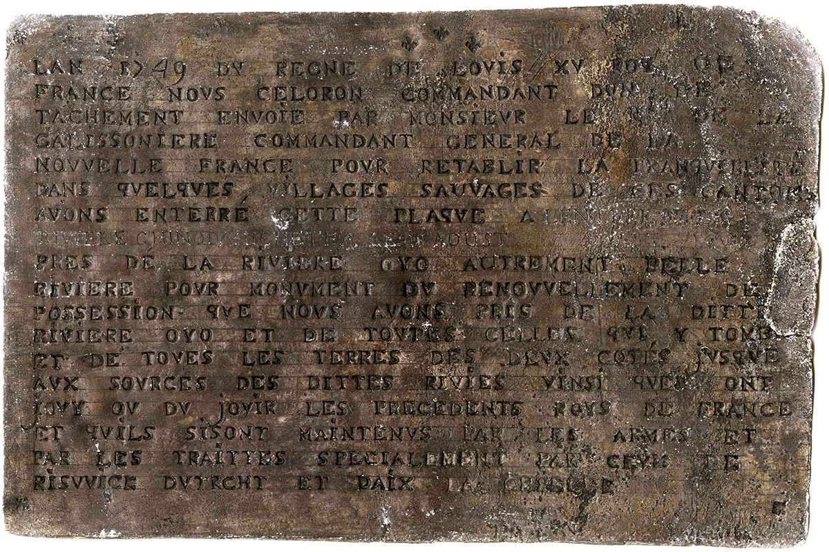
Courtesy Virginia Museum of History & Culture, 1849.1, www.virginiahistory.org.
Miami River
[A]rrived at the mouth of the Great Miama. There is a large sad bar a[t] the mouth, and the current or stream of it at present runs through the bar close round the uper point, the greater part of the bar being below; but when the water is up and flows over the bar the mouth of this river tends downward and is very wide; yet the stream now is by narrow.
—Thomas Rodney[2]9 October 1803. Dwight L. Smith and Ray Swick, ed., A Journey Through the West: Thomas Rodney’s 1803 Journal from Delaware to the Mississippi Territory (Athens: Ohio University Press, 1997), … Continue reading
North Bend of the Ohio
[W]e turned the western corner of the north bend of the Ohio, about 5 or 6 miles below Miama. [A]nd thence the river turns short to S by E and now our view and course is as it were for the first time directly toward our new intended home, that is southward and S westerly . . . .
—Thomas Rodney[3]Ibid., 109.
Strong Whirlpool
[J]ust after passing the turn there is a very large sand bar spreading from the Kentucky shore more than two thirds across the river, leaving only a narrow channel next the NW shore, at the head of which there is a riffle which still contracts the deep water to a narrow space; and below this is a strong whirlpool for some distance that takes great force of rowing to pass through safely.
—Thomas Rodney[5]Ibid., 110.
Sickly Settlers
[W]ent on shore to the only cabin near. The family was from London and had lived there two years. The man was a distiller and brewer by trade and was sick and deaf. They had two daughters. The eldest was sick and had gone abroad to one of the neighbours. The youngest about 12 years old was at home and was the only one of the family in health. A nephew lived with them, 9 or 10 years old. He had the ague.
—Thomas Rodney[6]Ibid.
Céloron on the Ohio
In 1749, Pierre Joseph Céloron de Blainville, traveled through the Ohio region. He left six lead plates like the one shown above claiming the land for France. Regarding the plate he left at the mouth of the Miami, he wrote:
I embarked to gain the Rock River, and at the entrance I had a leaden plate buried, and the arms of the King attached to a tree, of which I drew up an official statement . . . . The inscription is always the same . . . . This done, I embarked; owing to the scarcity of water in this river, it took thirteen days in ascending it.[7]C. B. Galbreath, ed., Expedition of Céloron to the Ohio Country in 1749 (Columbus, Ohio: The F. J. Heer Printing Co., 1921), 50.
The leaden plate shown above—written in French—reads:
L’AN 1749 DU REGNE DE LOUIS XV ROY DE FRANCE, NOUS CÉLORON, COMMANDANT D’UN DETACHEMENT ENVOIE PAR MONSIEUR LE MIS. DE LA GALISSONIERE, COMMANDANT GENERAL DE LA NOUVELLE FRANCE POUR RETABLIR LA TRANQUILLITE DANS QUELQUES VILLAGES SAUVAGES DE CES CANTONS, AVONS ENTERRE CETTE PLAQUE AU CONFLUENT DE L’OHIO ET DE TCHADAKOIN CE 29 JUILLET, PRES DE LA RIVIERE OYO AUTREMENT BELLE RIVIERE, POUR MONUMENT DU RENOUVELLEMENT DE POSSESSION QUE NOUS AVONS PRIS DE LA DITTE RIVIERE OYO, ET DE TOUTES CELLES QUI Y TOMBENT, et de TOUTES LES TERRES DES DEUX COTES JUSQUE AUX SOURCES DES DITTES RIVIERES AINSI QU’EN ONT JOUY OU DÛ JOUIR LES PRECEDENTS ROIS DE FRANCE, ET QU’ILS S’Y SONT MAINTENUS PAR LES ARMES ET PAR LES TRAITTES, SPECIALEMENT PAR CEUX DE RISWICK D’UTRECHT ET D’AIX LA CHAPELLE.[8]https://en.wikipedia.org/wiki/Pierre_Joseph_C%C3%A9loron_de_Blainville accessed on 24 Dec 2018.
English translation:
In the year of 1749, of the reign of Louis the 15th, King of France, we Céloron, commander of a detachment sent by Monsieur the Marquis de la Gallissonieré, Governor General of New France, to reestablish tranquility in some Indian villages in these provinces, have buried this plate at the mouth of the River Chinodahichiltha on the 18th of August near the River Ohio, otherwise Beautiful River, as a monument of the renewal of the possession we have taken of the said River Ohio, and of all those which empty into it, and of all the lands on both sides as far as the sources of said rivers, as enjoyed or ought to have been enjoyed by the kings of France preceding, and as they have there maintained themselves by arms and by treaties, especially those of Ryswick, Utrecht, and Aix la Chapelle.[9]Céloron plate, www.virginiahistory.org, accessed on 18 Feb 2019.
Notes
| ↑1 | No record exists of the boats’ journey below Cincinnati. Based on Thomas Rodney’s journal of his trip down this section and Cramer’s 1802 river guide, The Navigator, one conjecture is that the boats made it to the Miami River by this date. |
|---|---|
| ↑2 | 9 October 1803. Dwight L. Smith and Ray Swick, ed., A Journey Through the West: Thomas Rodney’s 1803 Journal from Delaware to the Mississippi Territory (Athens: Ohio University Press, 1997), 108. |
| ↑3 | Ibid., 109. |
| ↑4 | Ibid., 8. |
| ↑5 | Ibid., 110. |
| ↑6 | Ibid. |
| ↑7 | C. B. Galbreath, ed., Expedition of Céloron to the Ohio Country in 1749 (Columbus, Ohio: The F. J. Heer Printing Co., 1921), 50. |
| ↑8 | https://en.wikipedia.org/wiki/Pierre_Joseph_C%C3%A9loron_de_Blainville accessed on 24 Dec 2018. |
| ↑9 | Céloron plate, www.virginiahistory.org, accessed on 18 Feb 2019. |