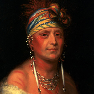
Monchousia (White Plume). Kansa (c. 1822)
Charles Bird King (1785–1862)
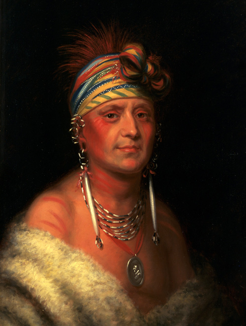
Courtesy the White House Historical Association.
Tradition and linguistic evidence has the Kansa, Osages, Omahas, and Quapaws originally as a single tribe living in the Ohio and Wabash river areas. By the time of the expedition, the Kansa were settled throughout the northern half of Kansas and in parts of Nebraska and Missouri. They would cede lands multiple times in the 1800’s, and in 1902, the Kansa accepted an agreement replacing their small reservation with individual allotments.[1]Garrick A. Bailey and Gloria A. Young, Handbook of North American Indians: Plains Vol. 13, ed. Raymond J. DeMallie (Washington, D.C.: Smithsonian Institution, 2001), 462, 471–73.
Known in the journals as Kanzas, Kansas, Kansias, Kansies, Kar sea, and Kah, they are popularly called the ‘People of the South Wind’. From Private Joseph Whitehouse‘s perspective at the mouth of the Kansas River in late June 1804, the Kansa were an imminent threat to his personal safety saying they:
form’d a temporary breast work with pickets, in order to defend ourselves against the Indians, fearing that they might make an attack on us in the Night.
The captains knew that the nearest Kansa village was 75 miles up the Kansas River and that in late June, most of the warriors would be many more miles west hunting buffalo on the plains. Perhaps the captains—having ordered the trees blocking the view necessary for accurate celestial observations chopped down—decided a military drill utilizing the fresh cut timber was in order. No Indians were ever seen during their stay at the mouth of the Kansas.
The Kansa were well-known players in the fur trade. Most recently, St. Louis trader Perrin Du Lac successfully traded with them bringing back a favorable report the year prior to Lewis and Clark’s arrival.[2]Extract from the Travels of Perrin du Lac, 1802, in Before Lewis and Clark: Documents Illustrating the History of the Missouri 1785–1804, ed. A. P. Nasatir, Bison Books edition. (Lincoln: … Continue reading Perhaps their fierce reputation came from the pre–1766 slave trade when they abducted Pawnees and Padoucas to sell as slaves to the French.
In the “Estimate of the Eastern Indians,” Clark gives this report:
The limits of the country they claim is not known. The country in which they reside, and from thence to the Missouri, is a delightful one, and generally well watered and covered with excellent timber: they hunt on the upper part of Kanzas and Arkanzas rivers: Their trade may be expected to increase with proper management. At present they are a dissolute, lawless banditti; frequently plunder their traders, and commit depredations on persons ascending and descending the Missouri river . . . . They cultivate corn, &c.[3]Moulton, Journals, 3:392–3.
In 1959, the Kaw Nation became a federally recognized tribe and reorganized their tribal government. It is headquartered in Kaw City, Oklahoma.[4]“Kaw People,” Wikipedia, https://en.wikipedia.org/wiki/Kaw_people, accessed on 11 January 2021.
Selected Pages and Encounters
June 28, 1804
The Kansa people
The expedition remains another day at the mouth of the Kansas where Lewis determines its latitude. Lewis describes the river and Clark describes the Kansa People.
September 14, 1806
Singing in "greatest harmoney"
Leavenworth, KS The expedition enters the lands of the Kansa Nation determined to prevent them from robbing the expedition. Three large trade boats from St. Louis bring news and provisions. At night, they sing in ‘greatest harmony’.
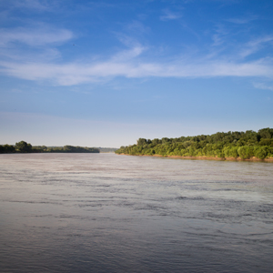
The Kansas River
by Joseph A. Mussulman
Clark was informed by one of the engagés who had traded along the Kansas that the river took its name from the Indians known as the Kanzes, or Kaw, nation which at that time dwelt on its banks.
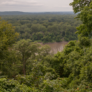
June 27, 1804
Forming a breast work
On a point of land between the Missouri and Kansas rivers the captains begin a series of navigational measurements. They also build a wall of timber and brush to prevent any attack from the Kaws.
June 5, 1804
Passing the Manitou
South of present Lupus, Missouri, the enlisted men and engagés struggle to move the boats past sandbars and channels clogged with driftwood. Ordway interprets a pictograph of a Manitou as a devil.
January 4, 1806
Jefferson's Indian speech
Fort Clatsop, OR Gass and Shannon travel t to the salt makers’ camp, and Lewis describes Clatsop Indian views on material goods. In Washington City, President Jefferson meets with an Indian delegation organized in part by Lewis and Clark.
July 2, 1804
An old French fort
Near present Leavenworth, Kansas, the expedition sets out early. They stop to construct a mast and make 11½ miles up the Missouri camping opposite an old Kansa village and French trading post.
Notes
| ↑1 | Garrick A. Bailey and Gloria A. Young, Handbook of North American Indians: Plains Vol. 13, ed. Raymond J. DeMallie (Washington, D.C.: Smithsonian Institution, 2001), 462, 471–73. |
|---|---|
| ↑2 | Extract from the Travels of Perrin du Lac, 1802, in Before Lewis and Clark: Documents Illustrating the History of the Missouri 1785–1804, ed. A. P. Nasatir, Bison Books edition. (Lincoln: University of Nebraska Press, 1990), 706–712. |
| ↑3 | Moulton, Journals, 3:392–3. |
| ↑4 | “Kaw People,” Wikipedia, https://en.wikipedia.org/wiki/Kaw_people, accessed on 11 January 2021. |