Of all the terrains the Lewis and Clark Expedition traversed between 1803 and 1806, the route down the Snake and Columbia Rivers, amongst dark menacing rocks and through ferocious whitewater rapids, was perhaps the most thrilling, dramatic, and geologically fascinating. What Sergeant Patrick Gass observed to be “so much uniformity in the appearance of the country,”[2]Moulton, ed., Journals, 10:155. belied an exceptionally active and relatively recent geologic history. This volatile past included lava flows of vast extent interspersed with periods of intensive fluvial erosion and sedimentation, punctuated by far more explosive volcanic events. These were followed by the deep scouring of the entire landscape by tremendous volumes of glacial meltwater bursting out from massive glacial lakes and rushing headlong from the Rocky MountainsRocky Mountains to the sea. In historic times, volcanic eruptions and immense landslides in certain locales physically altered the course of the Columbia, the West’s mightiest river. It is a geological story that could not have been imagined by Meriwether Lewis or William Clark, yet the observations of the corps along the Snake and Columbia Rivers provide evidence of catastrophic geological events scientists would not untangle and correctly interpret for nearly a century.[3]The study of the Columbia River Basalt Group has focused primarily on subdividing thousands of feet of undifferentiated volcanic deposits into different lava flows, fluvial deposits, and other types … Continue reading
Distribution of the Columbia River Basalt
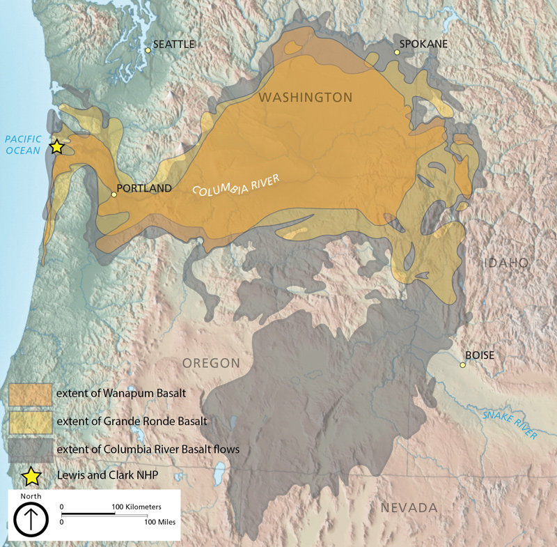
Map by Trista Thornberry-Ehrlich and Michael Barthelmes (Colorado State University) with information from Alt and Hyndman (1995, http://geology.isu.edu/Digital_Geology_Idaho/Module10/mod10.htm; accessed 29 July 2013). Base map by Tom Patterson (NPS), available at http://www.shadedrelief.com/physical/index.html (accessed 15 August 2019).[4]John Graham, “Geologic Resources Inventory Report,” Lewis and Clark National Historic Park, Natural Resource Report NPS/NRSS/GRD/NRR—2019/2023 (U.S. National Park Service, 2019), 6.
Columnar-jointed Basalts
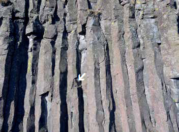
© John W. Jengo. Used by permission.
Columnar-jointed basalts of the Pomona Member of the Saddle Mountain Basalt, located 4.5 miles west of the confluence of the Snake and Clearwater rivers at Clarkston, Washington, and Lewiston, Idaho. Lewis and Clark never described these uniquely characteristic rocks as basalt, despite the fact they were the predominant geologic feature along the nearly 450-mile route down the Snake and Columbia Rivers to the Pacific Ocean. The outcrop scale is indicated by the one-foot-long rock hammer on the small ledge at center, indicated by the arrow.
Columnar Basalt Near Weippe
Jim Ford Creek
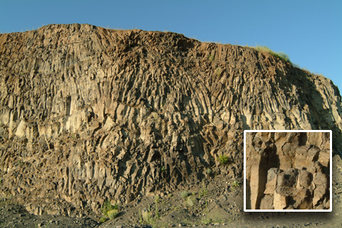
This cross-section of the Earth’s epidermis overlooking Jim Ford Creek was hidden from the view of Lewis and Clark and their men. Only in the 20th century, when State Highway 11 between Weippe and the Clearwater Canyon at Greer was paved, did a road-cut reveal this dramatic cross-section of the columnar jointings of volcanic basalt that form these high plateaus, illustrating at once the materials, forces, and chemistry by which they were created. But they saw the likes of it all the way down the Clearwater, Snake and Columbia as far as The Dalles. Some of them may have been curious about it, but nobody mentioned it. Anyway, 200 years ago very few geologists were yet equipped to interpret the language of this particular geological narrative. The columnar structure was observed in the late 17th century, mainly in Ireland and the Hebrides of Scotland (Fingal’s Cave), but not until the 1830s did anyone write of “prismoids of basaltes.[5]“Washington Irving, Adventures of Captain Bonneville, U.S.A., in the Rocky Mountains and the Far West (New York: G. P. Putnam, 1851), 317.
—Joseph Mussulman
Loess Dunes
Loess Dunes above Snake River Anticlines
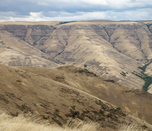
© 5 October 2008, above Wawawai, by Kristopher K. Townsend. Permission to use granted under the Creative Commons Attribution-Share Alike 4.0 International license.
During some unknown time, or perhaps during several unknown times since the flood basalts erupted, the climate of the region was extremely dry, and the plant cover extremely sparse. The wind swept dunes of dust out of the Pasco Valley north and northeast across the basalt plains, burying old valleys eroded before it arrived. That dust, widely known as the Palouse soil, covers large expanses of the flood basalts in eastern Washington and western Idaho.
Deposits of dust blown from dry regions invariably make extremely fertile soil that produces nutritious crops. And basalt, ugly as it is, contains generous allotments of most of the chemical elements that make the essential fertilizer nutrients. Those elements remain in the soil if the climate is as dry as the basalt plains. The combination of basalt bedrock, windblown dust, and a dry climate makes western Idaho and eastern Washington a naturally fertile region. Crops are generous and nutritious in that broad stretch of flood basalt plains between the hungry northern Rocky Mountains and the heavily forested Cascade Mountains. The Nez Perce Indians with their herds of fine horses thrived on the flood basalt lava flows.
—David Alt, 2004.
Columbia River Basalt Group
In general, the region of the lower Snake River and the Columbia River’s course through the Columbia Plateau and Columbia River Gorge experienced volcanic activity starting some 55 million years ago, although the expedition would primarily encounter rock units of Miocene-age.[6]Terry L. Tolan, Marvin H. Beeson, and Beverly F. Vogt, “Exploring the Neogene History of the Columbia River: Discussion and Geologic Field Trip Guide to the Columbia River Gorge—Part 1 … Continue reading Following their descent of the Clearwater River, the Lewis and Clark expedition passed through what is commonly referred to as the Columbia River Basalt Group (CRBG), one of the most extensive accumulations of basaltic lava on earth, deposited by eruptions that occurred between 17.5 and 6 million years ago. Basalt, of which more than 90 percent of all volcanic rocks are composed, is hard and dense with a dark, crystalline appearance. Unweathered surfaces of basalt are black, grayish-black, and dark to medium gray, but the rock weathers readily to a spectrum of lighter grays and rusty-colored appearances (such as reddish-gray, reddish-brown, yellowish-brown, and yellowish-orange) because of oxidation of its iron-rich mineral content.
For our purposes, it is unnecessary to describe the exhaustively complex sequence of over three hundred individual basalt flows of the CRBG, but it will be useful to know the general sequence of the major eruptive episodes in reference to the various basalt formations the Lewis and Clark expedition encountered. Initial eruptions between 17.5–17 million years ago formed the geographically limited Imnaha Basalt, but it was the more than one hundred individual lava flows between 17 and 15.5 million years ago that resulted in the Grande Ronde Basalt, the most voluminous and extensive formation composing 85 percent of the CRBG’s total volume.[7]Donald A. Swanson, Kenneth A. Cameron, Russell C. Evarts, Patrick T. Pringle, and Joseph A. Vance, “Cenozoic Volcanism in the Cascade Range and Columbia Plateau, Southern Washington and … Continue reading Later lava flows between 15.5 and 14.5 million years ago formed the Wanapum Basalt, which was followed by a long sequence of eruptive events lasting between 14 and 6 million years ago that deposited lavas collectively known as the Saddle Mountain Basalt.[8]Ibid. The composition of basalt and how it differs from other extrusive volcanic rock requires a brief digression into the functional mineralogy of magma. If the silica (the same silicon-oxygen … Continue reading Despite their low representations in volume, the expedition would encounter Wanapum Basalt and the Saddle Mountain Basalt rocks quite frequently during their journey because of their greater surface exposure.
The areal extent of these lava flows is simply astonishing, covering the upper third of the state of Oregon, the lower half of Washington State and much of the western border of Idaho, some 163,700 2 in extent.[9]Terry L. Tolan, Stephen P. Reidel, Marvin H. Beeson, James Lee Anderson, Karl R. Fecht, and Donald A. Swanson, “Revisions to the Estimates of the Areal Extent and Volume of the Columbia River … Continue reading That is 63,205 square miles, an area the size of Pennsylvania, New Jersey, Delaware, and Connecticut with enough lava left over to cover Washington, D.C. five times over. Geologists often refer to the CRBG lavas as “flood basalts,” which concisely summarizes their behavior when they broke out onto the earth’s surface. Such a flowable tendency explains why some CRBG lavas, discharging from fissures or vents located in northeastern Oregon, eastern Washington, and western Idaho,[10]Tolan, et al., “Neogene History,” 46:8, 88. could flow westward at speeds of 3 to 9 miles per hour (or faster) for hundreds of miles and, in some instances, breach both the ancestral Cascade and Coast mountain ranges, and reach the Pacific Ocean.[11]Marvin H. Beeson, Rauno Perttu, and Janice Perttu, “The Origin of the Miocene Basalts of Coastal Oregon and Washington: An Alternative Hypothesis,” Oregon Geology, 41:10 (October 1979): … Continue reading
Absence of Basalt Nomenclature in the Journals
Our “following the floods” story begins as the Corps of Discovery proceeded down the Snake River (beginning at present-day Lewiston, Idaho, and Clarkston, Washington, where it meets the Clearwater River) near the eastern edge of the basalt flows. This is where the expedition journal keeper’s observations of this dark-colored rock commence:
[11 October 1805:] The hills on the river are…rocky; the rocks of a dark colour. —Gass
[12 October 1805:] The hills or assents from the water is faced with a dark ruged Stone. —Clark
Despite the brevity of these and subsequent observations, the journal keepers captured the prevailing geologic feature, cliffs of dark-colored basalt, along this part of the Snake and Columbia Rivers route. An enduring mystery, however, and a question with no satisfactory answer, is why they never described the rocks they were encountering over the next several hundred miles as “basalt.” It is true that the mineralogical nature of basalt was unknown at this time, and that modern expertise in mineralogy and diagnostic indicators such as paleomagnetism are required to distinguish one basalt flow from another. Yet, there was an unmistakable description of basalt and its common columnar shape in Richard Kirwan’s Elements of Mineralogy,[12]Richard Kirwan, Elements of Mineralogy, 2nd Edition, Vol. 1 Earths and Stones (London: Printed by J. Nichols for P. Elmsly, in the Strand, 1794), and Richard Kirwan, Elements of Mineralogy, 2nd … Continue reading believed to be the only geology and mineralogy reference book carried by Lewis and Clark. Kirwan’s descriptions of basalt were easily recognizable and distinctive, whether he was describing the color (“greyish black, sometimes bluish, or brownish black; when withered [weathered], the surface is greyish, or reddish brown), shape (“generally of a columnar form, streight or curved, perpendicular or inclined”), geometry (“pentangular, hexangular, octangular”), or occurrence (“found in considerable masses”).
There is strong evidence the captains referred to Elements of Mineralogy at various times throughout the expedition,[13]For instances where the captains used terminology that is highly reminiscent of Kirwan’s technical phrasing, see pages 190-195 in John W. Jengo, “‘Mineral Productions of Every … Continue reading but it remains unexplained why they did not attempt any rock identification of this dominant lithology. This absence of basalt nomenclature in the journals is particularly puzzling given that virtually all the consolidated rocks the expedition encountered here were volcanic basalts, including miles upon miles of the characteristic hexagonal, columnar-jointed columns evident all along this portion of the route.
Lewis and Clark’s geologic observations from the confluence of the Clearwater and Snake Rivers to the mouth of the Sandy River may be less obvious at first glance than their remarks along the Missouri River, yet some of their most valuable and trenchant notations were made along this route. That many of these observations were made at times of great anticipation and unremitting apprehension is remarkable enough. To have their descriptions of natural phenomena confirmed by subsequent accounts of missionaries and expanded upon by modern scholarly research justifies recognizing the journalists of the corps as first-rate geological observers befitting their command of the aptly-named Corps of Volunteers for North Western Discovery.
Notes
| ↑1 | John W. Jengo, “After the Deluge: Flood Basalts, Glacial Torrent, and Lewis and Clark’s ‘Swelling, boiling ∓ whorling’ Route to the Pacific”, Part 1, We Proceeded On, August 2014, Volume 40, No. 3, the quarterly journal of the Lewis and Clark Trail Heritage Foundation. The original, full-length article is provided at lewisandclark.org/wpo/pdf/vol40no3.pdf#page=9. |
|---|---|
| ↑2 | Moulton, ed., Journals, 10:155. |
| ↑3 | The study of the Columbia River Basalt Group has focused primarily on subdividing thousands of feet of undifferentiated volcanic deposits into different lava flows, fluvial deposits, and other types of volcaniclastic sediments. Modern scientific advances that have facilitated this difficult work included determining that lava beds could be differentiated by their unique mineralogical oxide compositions, trace and rare earth elements, presence/absence of plagioclase phenocrysts, and paleomagnetic polarity. One particularly insightful outcome of this research was recognition that the ancestral Columbia River occupied different channels over time and that these former courses of the river were filled by lava flows from subsequent eruptions. |
| ↑4 | John Graham, “Geologic Resources Inventory Report,” Lewis and Clark National Historic Park, Natural Resource Report NPS/NRSS/GRD/NRR—2019/2023 (U.S. National Park Service, 2019), 6. |
| ↑5 | “Washington Irving, Adventures of Captain Bonneville, U.S.A., in the Rocky Mountains and the Far West (New York: G. P. Putnam, 1851), 317. |
| ↑6 | Terry L. Tolan, Marvin H. Beeson, and Beverly F. Vogt, “Exploring the Neogene History of the Columbia River: Discussion and Geologic Field Trip Guide to the Columbia River Gorge—Part 1 Discussion,” Oregon Geology, 46:8 (August 1984): 87-97. The Miocene Epoch was 23 to 5.3 million years ago. Some geologists use the physiographic term “Columbia Plain” because even the highest elevations of this region are bordered by mountains, but I opted to use the more familiar term “Columbia Plateau.” |
| ↑7 | Donald A. Swanson, Kenneth A. Cameron, Russell C. Evarts, Patrick T. Pringle, and Joseph A. Vance, “Cenozoic Volcanism in the Cascade Range and Columbia Plateau, Southern Washington and Northernmost Oregon,” 28th International Geological Congress (IGU) Field Trip Guidebook T106, 3–8 July 1989 (Washington, D.C.: American Geophysical Union, 1989). In addition to 85 percent of Grande Ronde Basalt, the CRBG is comprised of about 2 percent of another 17-15.5 million year old geographically limited unit called the Picture Gorge Basalt, 5.5 percent of Imnaha Basalt, 6 percent Wanapum Basalt, and 1.5 percent Saddle Mountain Basalt. |
| ↑8 | Ibid. The composition of basalt and how it differs from other extrusive volcanic rock requires a brief digression into the functional mineralogy of magma. If the silica (the same silicon-oxygen compound of ordinary beach sand) content of a magma is relatively low (<50-55 percent), it will form basalt, whose dark colors are a result of greater concentration of iron and magnesium. Progressive increases in the silica content in the magma, coupled with lessening concentrations of iron and magnesium, will form andesite and rhyolite, much lighter-colored rocks. What is important for our discussion of the geology of the CRBG is that basaltic lava is much less viscous than andesitic or rhyolitic lava, and thus, can flow more readily and over far greater distances. |
| ↑9 | Terry L. Tolan, Stephen P. Reidel, Marvin H. Beeson, James Lee Anderson, Karl R. Fecht, and Donald A. Swanson, “Revisions to the Estimates of the Areal Extent and Volume of the Columbia River Basalt Group,” in Stephen P. Reidel, and Peter R. Hooper, eds., Volcanism and Tectonism in the Columbia River Flood-Basalt Province, Special Paper 239 (Boulder, Colorado: Geological Society of America, 1989), 1-20. Although some geologists are now including basalts of the southeastern Oregon Plateau in the CRBG, thus changing the long-established volume percentages of the five basalt formations I just listed, and also increasing the overall areal extent of the regional basalt flows, I have excluded the Oregon Plateau basalts herein to remain representative of only the “Columbia River Basalts” province the expedition traversed. |
| ↑10 | Tolan, et al., “Neogene History,” 46:8, 88. |
| ↑11 | Marvin H. Beeson, Rauno Perttu, and Janice Perttu, “The Origin of the Miocene Basalts of Coastal Oregon and Washington: An Alternative Hypothesis,” Oregon Geology, 41:10 (October 1979): 159–166. Several reasons have been proposed to explain how CRBG lavas, which were actually more viscous than modern Kilauea lava, could have traveled westward over such long distances. These include a 1 to 2 degree slope from east to west, the sheer volume of the lava, and rate of eruptions that were 3-4 orders of magnitude faster than Hawaiian eruptions. See Swanson, et al., “Cenozoic Volcanism,” 23. |
| ↑12 | Richard Kirwan, Elements of Mineralogy, 2nd Edition, Vol. 1 Earths and Stones (London: Printed by J. Nichols for P. Elmsly, in the Strand, 1794), and Richard Kirwan, Elements of Mineralogy, 2nd Edition, Vol. 2 Salts, Inflammables, and Metallic Substances (London: Printed for P. Elmsly, in the Strand, 1796). See Kirwan, Mineralogy, 1:231-233 for Kirwan’s unambiguous descriptions of basalt. |
| ↑13 | For instances where the captains used terminology that is highly reminiscent of Kirwan’s technical phrasing, see pages 190-195 in John W. Jengo, “‘Mineral Productions of Every Kind’: Geological Observations in the Lewis and Clark Journals and the Role of Thomas Jefferson and the American Philosophical Society in the Geological Mentoring of Meriwether Lewis,” in Robert S. Cox, ed., “The Shortest and Most Convenient Route: Lewis and Clark in Context,” Transactions of the American Philosophical Society, 95:5 (2004),136-214. For examples of how the captains applied techniques described in Elements of Mineralogy, see John W. Jengo, “‘Blue Earth,’ ‘Clift of White’ and ‘Burning Bluffs’: Lewis and Clark’s Extraordinary Mineral Encounters in Northeastern Nebraska,” We Proceeded On, 37:1 (February 2011): 6-18 (http://lewisandclark.org/wpo/pdf/vol37no1.pdf#page=7). |
Experience the Lewis and Clark Trail
The Lewis and Clark Trail Experience—our sister site at lewisandclark.travel—connects the world to people and places on the Lewis and Clark Trail.
![]()
Discover More
- The Lewis and Clark Expedition: Day by Day by Gary E. Moulton (University of Nebraska Press, 2018). The story in prose, 14 May 1804–23 September 1806.
- The Lewis and Clark Journals: An American Epic of Discovery (abridged) by Gary E. Moulton (University of Nebraska Press, 2003). Selected journal excerpts, 14 May 1804–23 September 1806.
- The Lewis and Clark Journals. by Gary E. Moulton (University of Nebraska Press, 1983–2001). The complete story in 13 volumes.
This site is provided as a public service by the
![]()
Lewis and Clark Trail Alliance
with additional funding from the following:

