Sandy River
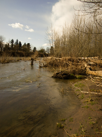
© 29 March 2009 by Kristopher K. Townsend. Permission to use granted under the Creative Commons Attribution-Share Alike 4.0 International license.
Over the course of a single day, the expedition traveled out from under an ancient river channel frozen in time[2]See on this site Rooster Rock at Crown Point. to a river discharging huge volumes of sediment in real time, the “quicksand river,” now known as the Sandy River. Both captains devoted time to accurately describe the nature of the sediment, the size of the delta it formed (the “Island” that Clark referred to below), and its source:
[3 November 1805:] I arrived at the enterance of a river which appeared to Scatter over a Sand bar, the bottom of which I could See quite across and did not appear to be 4 Inches deep in any part; I attempted to wade this Stream and to my astonishment found the bottom a quick Sand, and impassable . . . Capt Lewis and my Self walked up this river about 1½ miles to examine this river which we found to be a verry Considerable Stream Dischargeing its waters through 2 Chanels which forms an Island of about 3 miles in length on the river and 1½ miles wide, composed of Corse Sand which is thrown out of this quick Sand river Compressing the waters of the Columbia and throwing the whole Current of its waters against its Northern banks…This Stream has much the appearance of the River Platt: roleing its quick Sands into the bottoms with great velocity after which it is divided into 2 Chanels by a large Sand bar before mentioned. —Clark
[1 April 1806:] the Indians . . . informed us that the quicksand river which we have heretofore deemed so considerable, only extendes through the Western mountains as far as the S. Western side of mount hood where it takes it’s source . . . several different tribes informed us that it heads at Mount Hood. —Lewis
Nature of the Sediment
Sandy River Mouth
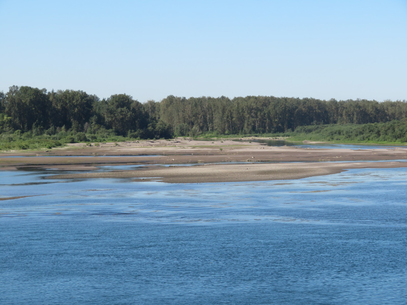
© 2022 by Robert Heacock. Used by permission.
Above: Eastern Sandy River mouth as viewed from the Columbia River. Given the size and nature of the Sandy River delta, the channels of the Sandy River have changed since Clark wrote about it. Today, there are two channels. The eastern channel is upstream from the larger main channel and closer to the river’s mouth in 1805.—ed.
Geologists have determined the expedition members were witnessing the aftermath of a circa winter 1781–1782 eruption of Mount Hood[3]Cross-dating of two “victim” trees indicated they perished after the A.D. 1781 growing season but before the A.D. 1782 growing season. See Patrick T. Pringle, Thomas C. Pierson, and … Continue reading that generated a rapidly-flowing slurry of rock and water (technically termed a “lahar”). The sizeable 1781[4]Not only does the visual cross-dating of tree ring growth patterns indicate a 1781 large scale eruptive event, dendrochemical evidence, namely an increase in phosphorus in rings of trees within the … Continue reading eruption of Mount Hood, located some thirty-five miles to the east-southeast of the Sandy River delta, triggered the latest sequence of perhaps hundreds of lahars coming off the southwest flank of the volcano,[5]Thomas C. Pierson, William E. Scott, James W. Vallance, and Patrick T. Pringle, “Eruption-Related Lahars and Sedimentation Response Downstream of Mount Hood: Field Guide to Volcaniclastic … Continue reading correctly noted by Lewis as the “source” of the river. Lahars can have different consistencies, and it appears from the captains’ transcription of Sgt. Pryor’s reconnaissance up the Sandy River that they were witnessing a flow of sand and fine gravel suspended in water, the conditions that form quicksand:
[1 April 1806:] the channel is not more than 50 yds and 6 ft deep . . . the bed of this stream is formed entirely of quicksand . . . The water is turbid and current rapid. —Lewis
Although apparently not part of Pryor’s detachment, Joseph Whitehouse also investigated the upstream portion of the Sandy River. Whitehouse’s next to last entry in his extant paraphrased journal provides additional detail of a river laden with a heavy sediment load:
[1 April 1806:] I went up Quick Sand River about 4 miles . . . full of Islands, and Sands barrs . . . I found this river part of the way up it, [to be] 6 feet deep, & the remainder as far up it as I went, only 6 inches deep of water & 4 inches quick sand.
A Whitehouse original journal entry, and the only indication in the Lewis and Clark journals of this simple test, described a member of the expedition probing the depth of the quicksand, perhaps employing something akin to a setting pole:
[3 November 1805] the mouth of which was filled with quick Sand So that we could run a pole 6 or 8 feet in it.
Whitehouse’s paraphrased journal entry from 3 November 1805, added that this probing revealed the river bed “had no solid bottom,” a practical indication of a river burdened with saturated, uncompacted sediment; the high percentage of water-filled void spaces permitted probing to depths that a more compacted deposit would not allow.
The Sandy River Delta
Mount Hood, which Clark described on 3 November 1805, as “of a Conical form but rugid,” was apparently very active until circa 1793[6]Thomas C. Pierson, Patrick T. Pringle, and Kenneth A. Cameron, “Magnitude and Timing of Downstream Channel Aggradation and Degradation in Response to a Dome-Building Eruption at Mount Hood, … Continue reading and there is some indication that its volcanic activity persisted until 1800-1801,[7]Patrick T. Pringle, Thomas C. Pierson, Kenneth A. Cameron, and Paul R. Sheppard, “Late Eighteenth Century Old Maid Eruption and Lahars at Mount Hood, Oregon (USA) Dated with Tree Rings and … Continue reading just four to five years prior to the expedition’s arrival. Thus, it is difficult to ascertain how much volcaniclastic sediment (Clark’s “Corse Sand which is thrown out of this quick Sand river”) originated from the initial 1781 Mount Hood eruption versus flows caused by post-1781 events. Either way, lahars that commenced with the 1781 eruption are believed to be the source of the sediment that traveled the entire fifty-four miles down the Sandy River drainage to the Columbia,[8]Pierson, et al., “Eruption-Related Lahars,” 223. creating a 2,500-acre delta that projects nearly two miles into the river. Until the advent of advanced age-dating techniques such as radiocarbon analyses and dendrochronology, the geological observations of the Lewis and Clark expedition at the Sandy River were the best source for deducing the timing of this volcanic event, refining the time frame expressed in Native American oral tradition.[9]Remarkably, the same Daniel Lee who documented the Native American oral history of a natural dam (the Bonneville landslide) blocking the Columbia River at the Cascades also recorded impressions about … Continue reading
The Cascade Range Volcanoes
Mount Hood
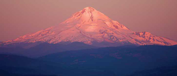
© John W. Jengo. Use by permission.
Mount Hood was one of the five “stupendious” Cascade Range peaks observed by Lewis and Clark, which Meriwether Lewis described as “conic pointed” and appearing “to lie in the same chain,” although neither captain recognized these mountains as volcanoes. The rapidly-flowing slurries of rock and water (called lahars) that commenced with the 1781 eruption of Mount Hood were the source of the “quick sands” noted by the expedition members at the mouth of the Sandy River.
When the captains summed up their observations about the Columbia River on the return journey, Lewis noted:
[14 April 1806:] the bed [of the river] is principally rock except at the entrance of Labuish’s river [Hood River] which heads in Mount hood and like the quicksand river brings down from thence vast bodies of sand.
Interestingly, Lewis had just correctly identified the other principal conduit by which Mount Hood lahars discharged into the Columbia River, including perhaps the largest single debris avalanche recorded from Mount Hood. This was an outpouring that discharged down the Hood River with enough energy to completely cross the Columbia River, and surge three miles up the White Salmon River.[10]Donald A. Swanson, Kenneth A. Cameron, Russell C. Evarts, Patrick T. Pringle, and Joseph A. Vance, “Cenozoic Volcanism in the Cascade Range and Columbia Plateau, Southern Washington and … Continue reading But just like the absence of basalt nomenclature in the journals (despite passing hundreds of miles of volcanic rock exposures), the captains never deduced that Mount Hood or the other Cascade peaks they directly observed (Mounts Adams, Jefferson, St. Helens, and Rainier) were volcanoes. We can now read Meriwether Lewis’s 6 April 1806, summary observation that these “stupendious mountains,” some of them “conic pointed,” appeared “to lie in the same chain” and see clear evidence of the continental arc that forms above a seduction zone of a plunging oceanic tectonic plate, but we must concede in fairness that such a deduction has only become common wisdom over the last few decades. As such, we can forgive the captains that the corps twice passed “among the sleeping giants”[11]Donald Jackson, Among the Sleeping Giants: Occasional Pieces on Lewis and Clark (Urbana, Illinois: University of Illinois Press, 1987), p. 23–26. (borrowing historian Donald Jackson’s clever turn of phrase) unaware they were the very object “worthy of notice” that would have splendidly fulfilled Thomas Jefferson’s instructions to seek “volcanic appearances.”[12]Selected quotes from the Jefferson instructions from Donald Jackson, ed., Letters of the Lewis and Clark Expedition, with Related Documents: 1783-1854, Second Edition (Urbana, Illinois: University of … Continue reading
First-Rate Geological Observers
Upon exiting the Columbia Gorge, the last great unmapped country of their outbound journey, the expedition confronted many weeks of considerable trial, tribulation, and ultimately triumph on their path to the Pacific Ocean. Lewis and Clark’s geologic observations from the confluence of the Clearwater and Snake Rivers to the mouth of the Sandy River may be less obvious at first glance than their remarks along the Missouri River, yet some of their most valuable and trenchant notations were made along this route. That many of these observations were made at times of great anticipation and unremitting apprehension is remarkable enough. To have their descriptions of natural phenomena confirmed by subsequent accounts of missionaries and expanded upon by modern scholarly research justifies recognizing the journalists of the corps as first-rate geological observers befitting their command of the aptly-named Corps of Volunteers for North Western Discovery.
Plan Your Own Experience!
The Sandy River Delta is accessible to the public:
- Sandy River Delta @ lewisandclark.travel
Notes
| ↑1 | John W. Jengo, “After the Deluge: Flood Basalts, Glacial Torrents, and Lewis and Clark’s “Swelling, boiling & whorling” River Route to the Pacific,” Part 2, We Proceeded On, November 2015, Volume 41, No. 4, the quarterly journal of the Lewis and Clark Trail Heritage Foundation. The original, full-length article is provided at lewisandclark.org/wpo/pdf/vol41no4.pdf#page=10. |
|---|---|
| ↑2 | See on this site Rooster Rock at Crown Point. |
| ↑3 | Cross-dating of two “victim” trees indicated they perished after the A.D. 1781 growing season but before the A.D. 1782 growing season. See Patrick T. Pringle, Thomas C. Pierson, and Kenneth A. Cameron, “A Circa A.D. 1781 Eruption and Lahars at Mount Hood, Oregon—Evidence from Tree-Ring Dating and From Observations of Lewis and Clark in 1805-6 [Abstract],” Geological Society of America Abstracts with Programs, 34:6 (October 2002), 511. |
| ↑4 | Not only does the visual cross-dating of tree ring growth patterns indicate a 1781 large scale eruptive event, dendrochemical evidence, namely an increase in phosphorus in rings of trees within the ash fall area, confirm that Mount Hood erupted in 1781. See Paul R. Sheppard, Russ Weaver, Patrick T. Pringle, and Adam J.R. Kent, “Dendrochemical Evidence of the 1781 Eruption of Mount Hood, Oregon,” in Markus Stoffel, Michelle Bollschweiler, David R. Butler, and Brian H. Luckman, eds., Tree Rings and Natural Hazards: A State-of-the-Art, Advances in Global Change Research 41 (Heidelberg, London, New York: Springer, 2010), 465-467. |
| ↑5 | Thomas C. Pierson, William E. Scott, James W. Vallance, and Patrick T. Pringle, “Eruption-Related Lahars and Sedimentation Response Downstream of Mount Hood: Field Guide to Volcaniclastic Deposits along the Sandy River, Oregon,” in O’Connor, et al. Volcanoes to Vineyards, 221-236. |
| ↑6 | Thomas C. Pierson, Patrick T. Pringle, and Kenneth A. Cameron, “Magnitude and Timing of Downstream Channel Aggradation and Degradation in Response to a Dome-Building Eruption at Mount Hood, Oregon,” Geological Society of America Bulletin, 123:1-2 (January 2011), 3-20. |
| ↑7 | Patrick T. Pringle, Thomas C. Pierson, Kenneth A. Cameron, and Paul R. Sheppard, “Late Eighteenth Century Old Maid Eruption and Lahars at Mount Hood, Oregon (USA) Dated with Tree Rings and Historical Observations,” in Stoffel, et al., Tree Rings, 487-491. |
| ↑8 | Pierson, et al., “Eruption-Related Lahars,” 223. |
| ↑9 | Remarkably, the same Daniel Lee who documented the Native American oral history of a natural dam (the Bonneville landslide) blocking the Columbia River at the Cascades also recorded impressions about the Sandy River in September 1838. During a trip overland from The Dalles to the Willamette Mission to obtain cattle (one of the few times he made this trip circumventing the Cascades), Lee encamped along the Sandy River with his small party, which included two Chinooks and two Walla Wallas. Lee noted: “This rapid stream rises at the base of Mount Hood . . . about fifteen miles off. The fires that once raged within its bowels, and blazed at its top, seem to have been long extinguished. Native tradition says that fire was anciently seen upon it, and that sounds were heard by the hunters, who approached near it, like the report of muskets.” Lee and Frost, Ten Years in Oregon, 157. |
| ↑10 | Donald A. Swanson, Kenneth A. Cameron, Russell C. Evarts, Patrick T. Pringle, and Joseph A. Vance, “Cenozoic Volcanism in the Cascade Range and Columbia Plateau, Southern Washington and Northernmost Oregon,” 28th International Geological Congress (IGU) Field Trip Guidebook T106, 3–8 July 1989 (Washington, D.C.: American Geophysical Union, 1989), 1-60. |
| ↑11 | Donald Jackson, Among the Sleeping Giants: Occasional Pieces on Lewis and Clark (Urbana, Illinois: University of Illinois Press, 1987), p. 23–26. |
| ↑12 | Selected quotes from the Jefferson instructions from Donald Jackson, ed., Letters of the Lewis and Clark Expedition, with Related Documents: 1783-1854, Second Edition (Urbana, Illinois: University of Illinois Press, 1978), 1:63. |
Experience the Lewis and Clark Trail
The Lewis and Clark Trail Experience—our sister site at lewisandclark.travel—connects the world to people and places on the Lewis and Clark Trail.
![]()
Discover More
- The Lewis and Clark Expedition: Day by Day by Gary E. Moulton (University of Nebraska Press, 2018). The story in prose, 14 May 1804–23 September 1806.
- The Lewis and Clark Journals: An American Epic of Discovery (abridged) by Gary E. Moulton (University of Nebraska Press, 2003). Selected journal excerpts, 14 May 1804–23 September 1806.
- The Lewis and Clark Journals. by Gary E. Moulton (University of Nebraska Press, 1983–2001). The complete story in 13 volumes.
This site is provided as a public service by the
![]()
Lewis and Clark Trail Alliance
with additional funding from the following:

